ground water (1)
 Call Kai
 Learn
 Practice Test
 Spaced Repetition
 Match
 Flashcards
 Knowt Play
1/42

There's no tags or description
Looks like no tags are added yet.
43 Terms
define groundwater
water located within saturated geological structures (rocks) underground stored in aquifers
define water table
surface along which water pressure = ambient atmospheric pressure → pressure head ψ = 0
define aquifer
saturated geological unit that is sufficiently permeable (pores) that water flows through it faster than through adjacent, less permeable, geological units
→ rock that allows water to be stored & moved (easier)
→ unconfined OR confined
define aquiclude
saturated geological unit that has sifficiently low permeability → water flow is RESTRICTED relative to adjacent, more permeable, geological units
more challenging to flow through
aquifer vs aquiclude
aquifer: GW flows through, high permeability
aquiclude: GW blocked/restricted, low permeability
difference in geological properties
types of aquifers (2)
unconfined
confined
differences caused by differences in geologic properties

unconfined aquifer
not confined above by an aquiclude
water table may rise and fall in response to changes in GW storage
accessible from surface
water can come & go, no layer covering/restrictions
confined aquifer
confined above by an aquiclude
aquiclude sits on top of aquifer
artesian aquifer
CONFINED aquifer that is under enough pressure such that if a well is drilled into the aquifer, water level in well will RISE above the bottom of the confining layer THEN accessible
flowing artesian well: doesnt require pumping, flows out
geological properties (types of layers)
features in landscapes created by geological units
bedrock (sedimentary)
bedrock (crystalline)
unconsolidated or surficial deposits
bedrock (sedimentary)
discharge from sedimentary aquifers occurs where a downstream stratum (one geological layer) is exposed to the surface
provides relatively constant contribution to streamflow
water bearing rock → sediment deposits → increase in porosity → water can move & be stored easily → contributes to streamflow
formed by sediment deposit → compaction → cementation
bedrock (crystalline)
often treated as impermeable in water balance analysis
(assumed to allow NO GW flow through it when calculating water balance)
but not always valid
GW flow occurs via discrete fractures
can influence water balance for small catchments
water harder to move through → requires fractures
unconsolidated or surficial deposits
ex. floodplains, alluvial fans, eskers, talus, moraines, glacio-fluvial outwash
high permeability → unconsolidated (sediments not yet cemented/compacted into solid rock!)
loose material moved via different movement.. piles of materials formed
water easily stored & moved through
what is the GW balance? (GW storage)
ΔGW = inputs - outputs
inputs: "recharge” → into aquifer
percolation (downward movement of water through rock via gravity)
infiltration from surface water
artificial recharge
outputs: “discharge” → out of aquifer
discharge into streams & lakes
seepage (water slowly leaks/ moves through rock)
soil evaporation
transpiration (plant absorption)
pumping from wells
relation between ΔGW and water table position
GW storage is expressed as a volume per unit area (i.e., a depth)
SY: the fraction of the aquifer volume that will DRAIN when the water table drops (or that will fill when the water table rises) → equivalent to “gravitational water” or “drainable porosity” for a soil
dependent on material/grain size

specific retention vs specific yield
specific retention: water retained in soil/rock after gravity drainage (after water table drops)
how wet is spong after run out?
ex. clay holds water tight
specific yield (SY): water that drains out of soil/rock due to gravity
releases water
ex. sand easily releases water

porosity in relation to SY and SR
SY & SR describe what happens to the water occupying pore space
ex. clay retains more water, harder for water to drain
ex. cobbles most efficient for drainage, least amount of water retained
porosity impacts storage, SR, and SY
GW regimes
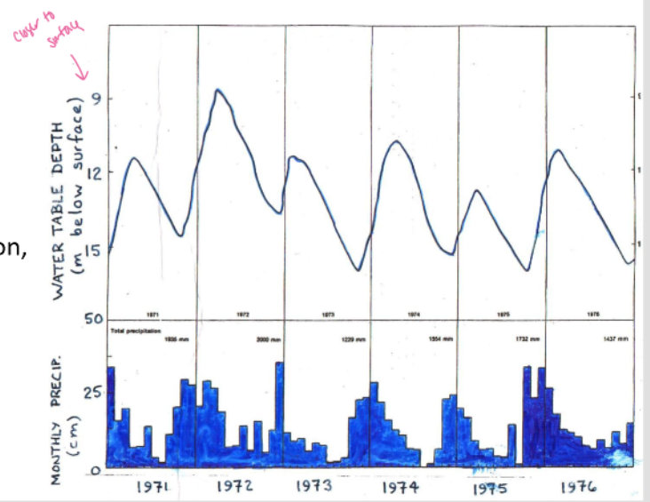
rain-dominated: recharge occurs during atumn-winter rainy season
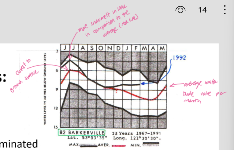
snowmelt-dominated: recharge occurs during spring-summer snowmelt
impacts timing of increased or decreased GW
snowmelt-dominated water table fluctuations
rain-dominated water table fluctuations

water table fluctuations in relation to precipitation
more rainfall during early seasons of year → higher table depth
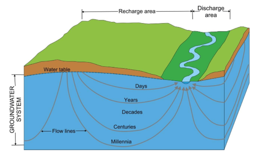
groundwater flow illustration (through space)
Recharge: Water infiltrates and percolates downward through soil to reach an aquifer
Groundwater flow: Groundwater moves from areas of high h to areas of low h (hillslope → valley/stream channels)
Storage: Groundwater is stored within the pores and fractures of aquifers
Continued flow: Groundwater continues moving along the hydraulic gradient. Its direction may change depending on the hydraulic head distribution
Discharge: Groundwater eventually exits through streams, lakes, springs, or wells

graphical representation of GW flow (types)
equipotential lines and water table contours: connect points w/ equal hydraulic head (h)
flow lines show path GW takes as it moves
two types of representation:
1. water table map (plan view)
2. flow net (vertical cross-section)
water table map
drawn water table & total hydraulic head → which way will water move? (high → low)
water table elevation
GW flows from higher water table elevation → lower water table elevation
where water table is high or low across a lanscape (and the general direction GW flows)
viewed top-down
dependent on knowing depth of wells across landscape, where contours and thus GW flow are interpolated from well observations!!!!!!!!!!!!!

flow net
water moves along equipotential lines at 90° angles → water movement curves in U shape
GW flow pattern
closely spaced equipotential lines = steeper h gradient, generally faster flow
viewed cross-seciton

stream-GW interactions: discharge and recharge
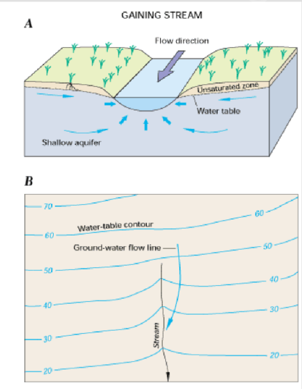
stream-GW interactions: GAINING streams
water table sloping toward the stream from both sides
stream-GW interactions: LOSING streams
water table sloping away from the stream from both sides

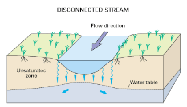
stream-GW interactions: LOSING streams (disconnected stream)
stream perched above the water table (losing)
stream-GW interactions: hyporheic exchange
involves infiltration of streamwater into the bed/banks, after which it flows some distance downstream before discharging back into the stream
processes depend on morphology of stream and riparian zone
ex. A: pool-riffle stream
ex. B: meandering floodplain stream
ex. also step-pool environments

stream-GW interactions: effects of changes in streamflow
during base flow: GW discharges into stream
during high flow event: stage rises, stream water infiltrates bed and banks
flowing event: stage drops, bank storage flows back into the stream
GW source of discharge at low recharge periods → if water is flowing where is it coming from? inputs vs storage?

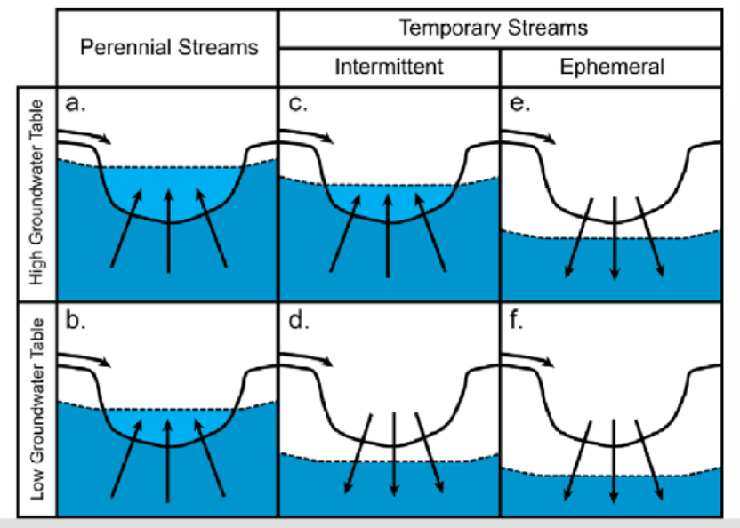
stream-GW interactions: types of streams
perennial stream: always flowing
intermittent stream: dry in dry season
ephemeral stream: only during and shortly after rainfall
stream-GW interactions: riparian vegetation
riparian veg: veg area beside stream → health driven by stream health
less water in stream w/ presence of veg → as opposited to w/o
evapotranspiration
uptake via roots from stream/GW/water table
plants have lower demand for water @ night (no photosynthesis)

darcy’s law of GW flow
used to determine GW flow
function of hydraulic conductivity and the difference in depth and distance between hydraulic heads

visual representaiton of ΔH vs ΔL


in-class example calculation 1


in-class example calculation 2
porosity important as it impacts how quick water can move!! (rate of movement)
→ water only moves through pore space

monitoring GW globally → GRACE
(Gravity Recovery And Climate Experiment)
distance between 2 twin satellites impacted by gravitational pull over different parts of earth
difference in land cover type → diff grav pull due to land mass
fluxuations (land doesnt change much as opposed to water table → measure water table)
allows us to measure changes in surface & GW, seasonal ppt & flow, water movement (using fluxes)
how can we analytically estimate the effects of GW abstraction on streamflow, using only streamflow records?
baseflow (lowest point, smooth part of graph) provides insight into GW (contribution)
how might baseflow increase/decrease over time
ppt & rainfall → GW movement driven in hydraulic head, small spikes due to inputs

how does the water level vary in a hillslope draining to a stream?
table water depth in relation to hillslope & why?
depends on hydraulic head, soil material, vegetation, seasonality
water table deeper near hilltop → becomes shallower downhill towards stream → GW flows toward stream → water table may intersect surface at stream → GW discharge

why is GW fed streamflow so much younger/older than GW storage in the landscape?
GW fed streamflow can be a mix (young/old)
but younger makes up larger fraction
movement closer to surface is faster → what ends up in stream channel
deeper GW residence time is much longer
→ GW age also determined using Darcy’s law with info on time and aquifer porosity
identifying runoff sources: end-member mixing analysis (EMMA)
how much of stream channel comes from GW in comparison to rainfall? → sources & mixing @ stream channel
done by identifying unique chemical signatures/properties of what you end up with
allows us to determine contribution of different water sources to streamflow
function of conservative tracers (e.g., temp and concentration) and total discharge
→ assumed that all end-members are constant and different from each other, all sources are considered, and stream is well mixed


in-class example calculation EMMA
