GEO.3425 - FINAL
 Call Kai
 Learn
 Practice Test
 Spaced Repetition
 Match
 Flashcards
 Knowt Play
1/139

There's no tags or description
Looks like no tags are added yet.
140 Terms
Aeolian
wind action and wind processes
movement and erosion of particles by wind
erosion, transportation, and deposition of materials
Modes of Transport by Wind
Suspension
Saltation
Surface Creep
Suspension
fine particles suspended in the air
Saltation
bouncing and skipping of slightly larger particles
impact: when grains hit other grains and knock them into the air
Surface Creep
grain size to large for saltation; pushed forward by saltating particles
Major Types of Aeolian Erosional Processes
Deflation
Abrasion
Deflation
wind erodes/removes loose fine grained material
transported away, heavier materials remain
Abrasion
when two materials are rubbed together and slowly abrade/grind away at each other
sandpaper effect performed by the wind
often restricted to the area immediately above the ground
Desert Pavement
type of deflation
larger deposits remain and create an armored surface of coarser grained sediments across a windy surface
Ventifacts
artifacts of the wind
pitted, grooved, polished
Yardangs
large-scale, wind-sculpted rocks
Types of Deserts
Subtropical Deserts
Rain Shadow Desert
Continental Desert
Polar Desert
Coastal Desert
Subtropical Desert
Sahara Desert
Rain Shadow Desert
Death Valley
Continental Desert
Gobi Desert
Polar Desert
Antarctica
Coastal Desert
Namib Desert
Four Major U.S. Deserts
Mojave
Great Basin
Sonoran
Chihuahaun
Wind
horizontal movement of air across Earth’s surface
produced by differences in pressure between one location and another
two main properties: speed and direction
Santa Ana Winds
develop in Southern California when there is high pressure over the Great Basin
air is warmed and dried as it moves and creates significant fire danger
Chinook Winds
air descends a mountain barrier and its relatively humidity lower the air compresses and warms
produces relatively warm, dry conditions
Katabatic Winds
larger, regional winds
gravity drainage winds
thermal high pressure (cold, dense air) flows downslope from elevated plateaus or highlands
ice sheet winds
Ripples
smallest aeolian landform
small ridges of sand that form throughs and crests
Morphology of Sand Dunes

3 General Shapes of Dunes
Crescentic Dunes
Linear Dunes
Star-shaped Dunes
Types of Dunes
Barchan
Parabolic
Longitudinal
Transverse
Barchanoid
Star-Shaped
Barchan
crescentic dunes with the horns of the dunes pointed downwind

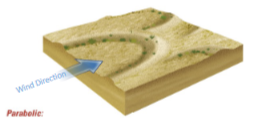
Parabolic
crescentic dunes with the horns pointed upwind
horns typically anchored by vegetation
Longitudinal
linear, ridge shaped dune
aligned parallel with the wind direction

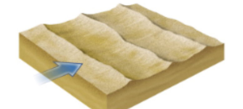
Transverse
long, slightly sinuous w/ asymmetrical ridge
only one slip face
aligned perpendicular to wind direction
Barchanoid
wavy, asymmetrical
formed from coalesced barchans w/ ridges aligned perpendicular to effective winds

Star-Shaped
formed in areas w/ no dominant wind direction
lower winds just the arms migrate; higher winds the center stars migrate

Desertification
the degradation of land in arid, semi-arid, and dry sub-humid areas
driven by human activities (such as overgrazing, deforestation, and poor agricultural practices) and climate variations
results in the loss of vegetative cover and biological productivity
Karst Definition
terrain in which soluble rocks are altered above and below ground
Lithology of Karst Rocks
develops primarily on limestone (also forms in dolomite (slowly) and evaporites (halite and gypsum))
greater and % of calcite, the more karst develops
Porosity and Permeability of Karst
needs high porosity and high permeability
Chemical Reactions forming in Karst
Limestone (Calcite Dissolution)
H2CO3 + CaCO3 → Ca+2 + 2HCO3-
Conditions for Karst Formation
formations must have 60% or more calcium carbonate
Complexly jointed bedrock
Aerated zone between the ground surface and the water table
vegetation to supply organic acids that help dissolve the limestone
Karst Landforms
Sinkholes
Cockpit and Tower Karst
Stalactites + Stalagmites
Uvalas
Disappearing Stream: Sink vs. Spring
Collapse Sinkholes
sinkholes that form from the bottom up
groundwater dissolves bedrock underground until the surface collapses
not visible on the surface until they collapse
Solution Sinkholes
form from the top down
solution process create a depression that slowly deepens
Cockpit + Tower Karst
only occurs in the wet tropics where thick limestone beds are weathered into towers and gorges
can be over 600 feet high
Stalactites
attached to the ceiling
Stalagmites
attached to the floor
Uvalas
Disappearing Stream
Sink vs. Spring
Current Ice Age
Quaternary Ice Age
Holocene Epoch and Quaternary Period
Distribution of Ice in the World
Covers ~10% of Earth’s Surface
Antarctica, Greenland
Definition of Glaciers
large, non-stationary masses of ice formed by accumulation of snow into ice
Three Stages of Forming Glacial Ice
snow survives the summer
following winter to old snow is compressed and recrystallized into firn
dense glacial ice is formed as firn and snow are compressed and re-crystallized into a dense glacial ice
Firn
intermediate stage between snow and glacial ice
compact and granular texture
Two General Types of Glaciers
Alpine or mountain glaciers
Continental glaciers
Alpine Glaciers
glacier in a mountain range
four subtypes
1. Cirque
2. Valley
3. Piedmonth
4. Tidewater
Continental Glaciers
attached to land
“Ice sheets”
Ice Sheets
mass of glacier that covers more than 50,000km
Ice Cap
circular and covers area of less than 50,000km
Ice Field
elongated pattern usually less area than that of an ice cap
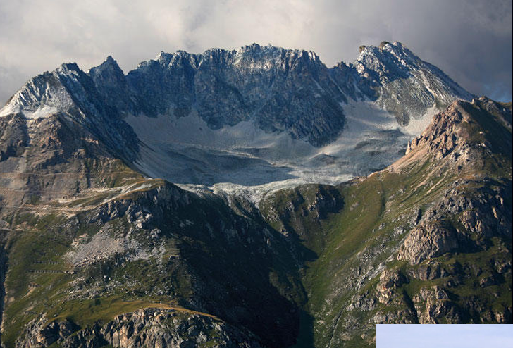
Cirque Glaciers
glacier in a bowl-shaped recess at the head of a valley
Valley Glaciers
in steeped wall valleys

Piedmont Glaciers
spread out as wide lobe as it leaves a narrow mountain valley to enter a wider valley or a plain

Tidewater Glaciers
glacier ends in a body of water influenced by tides

Two Ice Sheets in the World
Mass Balance
relationship between accumulation and ablation of snow and ice
Accumulation
Ablation
Equilibrium Line Altitude
Movement of Glaciers
Internal Flow
Extending and Compressive Flow
Basal Sliding
Internal Flow
increasing flow rate from bed to surface
Extending and Compressive Flow
velocity increases in extension zones
velocity decreases in compressive zones
Basal Sliding
process that occurs at contact between underlying glacial rock bed and glacier base
Regelation
process by which ice melts under pressure and then refreezes when the pressure is released; occurs mainly at the base of a glacier
pressure melting on the upslope side
refreezing on the downslope side
Glacial Features
Bergschrund
Crevasse
Bergschrund
Crevasse
deep v-shaped cleft formed in the upper brittle part of a glacier as a result of the fracture of ice undergoing extension
Glacial Landforms
Striations
U-shaped Valley
Roche Moutonnee
Erratics
Cirque
Arete
Tarn
small mountain lake where glacial cirque melted
Striations
U-Shaped Valley
glacier throughs give the valleys a more broadened wider base
Roche Moutonnee
rocky hillock w/ gently inclined smooth up-valley facing slope resulting from glacial abrasion and a steep rough down valley facing slope resulting from glacial plucking
Erratics
Cirque
armchair-shaped hollow w/ steep sides and back wall formed as result of glacial erosion on a mountain side
Arete
“knife edge” sharp, narrow, pinnacled ridge, formed as a result of glacial erosion from both sides
Glacial Depositional Landforms
Glacial Drift
Moraines
Esker
Kame Dumlin
Glacial Drift
general term for all glacial deposits both sorted and unsorted
Till
ice deposits that are unstratified and unsorted
Stratified Drift
sediments deposited by glacial meltwater which are sorted by size
Moraines
lateral
Medial
Terminal
Lateral Moraine
forms along each side of a glacier
Medial Moraines
two glaciers with lateral moraines join
Terminal Moraines
eroded debris dropped at the glacier’s farthest extent
Esker
sinuously curving, narrow ridge of coarse sand and gravel, forms along channel of melt-water stream under glacier
Kame
hill deposited directly by water, often in crevasse
Drumlin
elongated hill in the shape of an inverted spoon formed by glacial ice acting on underlying unconsolidated till or ground moraine
Periglacial
cold-climate processes, landforms, and topographic features that exist in cold NON-GLACIAL conditions regardless of their proximity to glaciers
Location of Periglacial
occupy more than 20% of Earth’s Land surface
in subarctic and polar climates
at high latitude or high altitude in lower-altitude mountains
Permafrost
occurs when soil or rock remains below freezing for at least two consecutive winters and the intervening summer
Continuous Permafrost
-7°C
Discontinuous Permafrost
-1°C
Active Layer
zone of seasonally frozen/thawing ground that exists between subsurface permafrost layer and the ground surface
thickness increased with decreasing latitude
Talik
unfrozen ground that may occur above, below, or within body of discontinuous permafrost or beneath a water body in the continuous zone