REAL Instrument Study Guide
 Call Kai
 Learn
 Practice Test
 Spaced Repetition
 Match
 Flashcards
 Knowt Play
1/70

Earn XP
Description and Tags
Easy Shit
71 Terms
What are the 6 basic Instruments?
The six basic instruments are
Attitude Indicator
Heading Indicator
Turn and Slip Indicator/Turn Coordinator
Airspeed Indicator
Altitude Indicator
Vertical Speed Indicator
What are the 2 methods of operation and the instruments to pair with them?
2 Method of Operations
Gyroscopic
Attitude Indicator
Heading Indicator
Turn and Slip Indicator/Turn Coordinator
Pitot Static
Airspeed Indicator
Altitude Indicator
Vertical Speed Indicator
What are the 2 Principals Gyroscopes Operate on?
2 Principals associated
Rigidity in space
The tendency of a rapidly spinning, heavy weighted gyroscope to remain fixed in a plane in which it is spinning
They are mounted on gimbals
Same thing as water staying level in a bottle
Precession
When a force is applied to a gyro, the force is applied in a 90 degree place relative to its movement
What 2 instruments does the vacuum system operate?
Attitude Indicator and Heading indicator
How does the vacuum system work?
Air enters through the vacuum air filter, the air then spins the gyro due to some vacuum cups on the gyro, then it filters out. The air is pushed through by an engine driven pump, and there is a relief valve that restricts the airflow to make it flow slower so the gyros don’t spin too fast. After it finishes, it goes through the overboard relief valve.

What happens if the relief valve fails in the vacuum system?
If the relief valve doesn't work
Shear drive pins aka safety pins are small plastic components that break and disconnect the pump from the system
Means there is a loss of airflow and no indication from the instruments
Attitude Indicator Operation
Used to determine attitude of the A/C when in IMC
Gives pitch and bank information
Operation:
Gyro spins in the horizontal plane and keeps the gyro part still, the casing moves with the aircraft and displays pitch and bank
Pendulous vanes: are moved out of position when the gyro tumbles, let out air to realign the gyro
What are the Errors of the Attitude Indicator
Banking and Pitch error
When making a 180 degree turn the gyro will show a false pitch up and bank, direction is differing between each indicator
Acceleration error
When you accelerate, the gyro may tumble and show a climb
When you decelerate, it may tumble and show a descent
Instrument Tumble
Instrument will begin to tumble when exceeding 100 degrees of bank or 60 degrees of pitch
What to look for on the preflight of an Attitude Indicator
Preflight Check
After 5 min, make sure the horizon bar is erect and align miniature airplane
No more than 1 bar of pitch or 5 degrees of bank during taxi
Look for red flags, meaning the instrument is inop
Heading Indicator Operation
Heading indicator operation
Uses rigidity in space and precession
Gyro spins in the vertical axis, this keeps the gyro still and the casing will rotate, there is a gear under the gyro that stays still with it, and free gyros that are moved by the still gear. This moves the face card
Due to no pendulous vanes, every 15 min you must use the small gear handle to turn the face card and align it with the mag compass
What are the errors of the heading indicator
HI Errors
Precessions: When the aircraft pitches, presecession makes the heading drift away from magnetic compass reading
Gyro tumbles with same limits as AI
What do you need to do to preflight the Heading Indicator
HI Preflight Check
Wait 5 minutes then set the HI with the CH
Every 15 minutes, check with compass and it needs to be within 3 degrees
Make sure face card turns the right way during taxi turns
Make sure there is no red flags
What are the 3 instruments that are forms of heading indicators
3 Types
CDI
No heading info
Reverse Sensing
HSI
Heading info
No Reverse Sensing
Radio Magnetic Indicator
The instrument used for NDBs
What does the Turn and Slip Indicator do?
Turn and Slip indicator
Super old
Gyro spins in the vertical plane, it is a single gimbal in which the gyro will stay the same and the casing turns with the aircraft and then the instrument will display rate of turn and direction of turn and the ball in kerosene will show turn quality it is in kerosene due to it being hard to freeze
What is different about the turn coordinator
Has a 30 degree canted Gyro which allows it to sense rate of roll initially along with rate of turn
Is electrically powered
What is a standard rate turn?
3 DPS
What are the magnetic instruments
Magnetic Instrument
Magnetic compass
Magnetic compass suspended in kerosene
Moves freely to the north
What are the Magnetic Compass Errors?
Deviation
Disturbance from electric components from the aircraft
Solved by compass card
Variation
Difference between true and magnetic north
Magnetic Dip
The magnetic compass with dip towards the north
Greater at the poles least near the equator
Oscillation
Magnetic compass is not reliable in turbulence
North Undershoot South Overshoot (Turning Error)
Always undershoot or overshoot 30 degrees when turning to north or south, decrease by 10 each 30 degrees
Accelerate north Decelerate South (Acceleration Error)
ASI Operation
Airspeed Indicator Operation
ASI receives ram air that goes into the diaphragm, the diaphragm will then expand and move the mechanical linkages. The static air line will then feed in static air to adjust the error due to less air coming in at higher altitudes
What are the Different Types of Airspeed
Types of airspeed
ICETG
IAS
CAS
IAS corrected for instrument and position error
Equivalent airspeed
CAS corrected for compressibility
200 knots or greater or 20,000ft or greater
TAS
Actual airspeed
Factors in humidity, temp
GS
What is the preflight for the ASI
Preflight check
Make sure it displays 0 on the ground
Make sure it comes alive on takeoff roll
Altitude Indicator Operation
The air in the aneroid wafers have standard pressure air in them (29.92) and as you go up the static port will pump outside air into the chamber, if there is less air (Higher) then the aneroid wafer will expand to make up for that and contract when there is more air as the wafers move, they move mechanical linkages and it will move the needles.
What are the types of altitude
Types of altitude
PATID
Pressure
Absolute
True
Indicated
Density
What is the preflight check for the altimiter
Preflight check
Set to local alt setting
Make sure it is within +- 75ft
VSI Operation
Has a diaphragm which is directly connected to the static port along with a calibrated leak leading to the chamber. As an airplane climbs, the diaphragm changed instantly, but the calibrated leak changed slower, and so the diaphragm contracts moving the mechanical linkages and moving the needle.
Has a 6-9 second delay
Gives trend and rate information
VSI Preflight Check
Check indication after startup, and make sure to determine what is used as the 0 indication
What is the angle of bank calculation used to calculate a standard rate turn and how does airspeed relate to rate of turn
Angle of bank
Calculation to get what angle of bank you need to get standard rate
TAS/10+5 angle of bank
As airspeed increases, rate of turn needs to increase
What does an electronic flight display do, and at minimum what does a technologically advanced aircraft have?
Electronic Flight Displays
Puts multiple flight instruments into 1 display
At minimum a Technical Advanced Aircraft has: PFD, MFD, GPS w/ moving MFD, and 2 axis autopilot
What does the PFD Display
The 6 basic flight instruments
What does the ADC display and how does it do it?
Air data computer
Delivers Pitot-Static information + OAT
Transfers all the information into binary code
Displays ASI, ALT, and VSI
What is the AHRS and what does it do, and what are the 2 types of gyros?
Attitude and Heading reference system
Works with the magnetometer and accelerometers which gives heading info
Provides all gyro system info
Uses Micro Electro Mechanical System Gyro
This gyro has a mass that is vibrated at a constant frequency on a specific axis
When the plane rotates about the axis them MEMS gyro is sensing, the corrolis effect will move the mass off center and the capacitor sensors will detect the rate of the movement on that axis
The rate will then be used to calculate total movement on that axis by the computer, and then GPS, Airspeed, Magnetometers and Accelerometers will be used to correct any errors in the calculation
Ring Lazer Gyro
This type of gyro shoots out 2 beams of light (lasers) into a fixed path with mirrors deflecting the lasers where they both travel in opposing directions (Clockwise and Counterclockwise)
There is then a sensor that measures the frequency from the beams
If the beams take the same amount of time to rotate, they have the same frequency and no change is detected
If the structure rotates (Which it rotates with changes in flight) then one beam will take a longer time to travel around and it will create an interference pattern which is then measured by the sensor and used to determine changes in the axis the gyro is measuring
There are 3 different gyros used to detect the 3 different axies of flight
What is the magnometer, and what error does it have?
Magnetometer
3 axis device that measures the magnetic field on each axis
No errors
What are all 6 busses and what does the emergency one provide?
Busses
HELENA
Hot
Essencial
Lighting
Emergency
PEACANS
PFD
EIS
Avionics lighting/dimming
Com 1
Audio
Nav 1
STBY instrument
Non-essential
Avionics
Why is an instrument scan used?
To prevent spacial disorientation
What are the 3 parts of instrument flying
Instrument flying
Done by continuously doing CIA
Crosscheck
Instrument Interpretation
Aircraft Control
What are the 3 errors people make in their scans
3 errors people have in scan
FOE
Fixation
Focusing on one instrument too much and not doing a crosscheck
Omission
Leaving out one of the instruments during the scan
Emphasis
Still doing a crosscheck but spending a lot of time on one instrument
What are the 2 instrument scanning methods?
2 airplane flying methods
Control performance method
ETCA
Establish bank, power, and pitch to known setting
Trim off pressure
Crosscheck with performance instrument
Adjust control instrument
You only have direct control on attitude and power
Spend 80% on AI and 20% on others
Primary and support method

What are all illusions
ICEFFLAGS
Inversion
Corrolis
Elevator
False Horizon
Flicker Veritgo
Leans
Autokenisis
Graveyard Spiral
Somatogravic
What is a VOR
A VOR is a VHF ground station (108.00 to 117.95 MHz) that gives an aircraft its magnetic bearing from the station, called a radial.
First, the station transmits two 30 Hz navigation signals on its carrier. The reference signal is frequency modulated onto a 9,960 Hz subcarrier (the frequency swings ±480 Hz, 30 times a second) and has the same phase in every direction. The variable signal is amplitude modulated: a rotating antenna pattern makes the signal strength rise and fall 30 times a second, and the timing of that rise and fall depends on direction from the station. They are sent in different forms so the receiver can tell them apart.
Next, the aircraft receiver separates them. An FM demodulator turns the subcarrier back into a 30 Hz reference signal, and an AM detector recovers the 30 Hz variable signal. The two are in phase at magnetic north, and the variable signal lags the reference by your bearing clockwise from the station. On the 030 radial, the lag is 30°. Travel time delays both signals equally, so it doesn’t change the measured lag.
The receiver compares that lag with the course set on the OBS, and the CDI/HSI displays the difference as needle deflection with a TO/FROM flag. One VOR gives a line of position, and a second VOR or DME gives a fix.
What is the difference between a radial, course, and heading?
Radial: This is a magnetic bearing from the station
Course: This is the desired path of flight selected by the pilot
Heading: Where the aircraft is pointing
What are the VOR navigation procedures?
Tune the NAV frequency of the VOR
Now, press ident and ensure the morris code appears and is the same as the one on the chart
Set desired OBS and fly to selected radial
What are the errors of a VOR?
Reverse sensing with a CDI:
If your aircraft is heading the opposite way of the selected radial, you will have to turn away from the needle to center it
Line of sight
The VOR signals cannot pass through obstacles
Cone of confusion
If you are in the cone 80 degrees above the VOR, then the signal will vary greatly with great deviations that should not be chased
What are all VOR facility types?
Facility Types
VOR
Normal VOR, tells location
VOR/DME
Provides location and distance
TACAN
You can pick up DME and get distance from them
VORTAC
VOR paired with a TACAN
Explain VOR Tests
If you want to fly IFR, within the previous 30 days you must have done one of these 4 types of tests:
VOR Ground (Max tolerance of 4 degree variation)
Air (Max variation of 4 degrees)
Dual (Max difference of 4 degrees between both radials)
VOT (Max variation of 4 degrees)
When done you need to record DEPS
Date
Error
Place
Signature
It does not need to be logged in a Mx logbook specifically but must be on a dedicated document
What is the VOR MON?
VOR MON
The Minimum Operational Network
If GPS goes out, the FAA is keeping 32 VORs to make sure if you are above 5000ft, you can follow a VOR to land
Each airport with an MON VOR, they all have a legacy approach
This means either an ILS, Localizer, and VOR
What is a DME?
Distance Measuring Equipment is a ground based transponder operating in the Ultra-High Frequency (UHF: 962-1213MHz)
First, the aircraft sends out pulse pairs of interrogation signals that travel to the DME, where the DME receives the signal and transmits a reply signal which is a different frequency to not confuse it with the interrogation.
Then the aircraft subtracts a delay of 50 microseconds, which was how much time the DME waited to send the signal back, and then halves the round trip time and uses the speed of light to do a time/speed calculation to get slant range distance from the station
What are all the uses for a DME?
Can identify fixes
Can fly DME arcs
Can do stepdown fixes
Can use to identify FAF
GPS can substitute a DME but you must monitor the frequency
What are the limitations to a DME?
Slant distance
The slant distance will be displayed to an aircraft which is the distance including the straight line and height meaning if you are 6,000ft above the station, it will still show you as 1 mile away
Line of Sight
Signal cannot pass through obstructions
What is an NDB
It is a non-directional beacon which is a ground based radio station, transmitting a low-medium frequency (190-535MHz) signal in all directions used by the Automatic Direction Finder to point towards the station. It also transmits a morris code identifier which must be present the whole time when tracking the NDB
What are the types if ADFs
There are 2 types of Automatic Direction Finders:
Relative Bearing Indicator
Used to determine the relative bearing
Radio Magnetic Indicator
Magnetic bearing mixed with magnetic heading
What are the 3 bearing concepts for the NDB?
Relative bearing
Angle from A/C nose to the station, measured clockwise
Magnetic bearing
Bearing to the station in reference to magnetic north
Magnetic bearing equals: MH+RB
What is the difference between homing and tracking?
Homing: Pointing the nose to the station
Tracking: Applying WCA
What are the errors for the NDBs?
Lightning or static error
They will have incorrect readings
Nighttime
The signal bounces off aircraft
Shoreline
The needle will curve towards the shoreline
Bank Error
The needs is not stable when you are banked so it will not be 100% accurate
Electrical
Has electrical interference
What are the service volumes for NDBs?
Compass locator
15nm from NDB
Medium Homing
25nm from NDB
Homing
50nm from NDB
High Homing
75nm from NDB
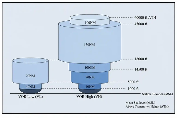
What are the VOR Service volumes (Legacy)
Terminal
Altitude: 1000-12,000ft ATH
Range: 25nm
Low
Altitude: 1000-18,000ft ATH
Range: 40nm
High
1st ring
Altitude: 1,000-14,500ft ATH
Range: 40nm
2nd ring:
Altitude: 14,500-18,000ft ATH
Range: 100nm
3rd ring:
Altitude: 18,000-45,000ft ATH
Range: 130nm
4th ring:
Altitude: 45,000-60,000 ATH
Range: 100nm

What are the VOR service volumes (New)
Low
1st ring:
Altitude: 1,000-5,000 ATH
Range: 40nm
2nd ring
Altitude: 5,000-18,000 ATH
Range: 70nm
High
1st Ring
Altitude: 1,000-5,000 ATH
Range: 40nm
2nd ring
Altitude: 5,000-14,500 ATH
Range: 70nm
3rd Ring
Altitude: 14,500-18,000 ATH
Range: 100nm
4th ring
Altitude: 18,000-45,000 ATH
Range: 130nm
5th Ring
Altitude: 45,000-60,000 ATH
Range: 100nm
What are the DME service volumes?
Low
Altitude: 12,900-18,000 ATH
Range: 130nm
High:
1st ring
Altitude: 12,900-45,000 ATH
Range: 130
2nd ring
Altitude: 45,000-60,000 ATH
Range: 100nm

What is GPS?
The Global Positioning System (GPS) is a satellite‑based navigation system operated by the U.S. Department of Defense.
GPS satellites continuously broadcast precise time and position information.
The aircraft’s GPS receiver measures the time delay of these signals from multiple satellites and uses that data to compute the aircraft’s exact position, which is then displayed on the aircraft’s navigation systems.
The GPS system can serve as a navigation source for Area Navigation (RNAV)
What information is given based on 1-6 satellites?
1 sat: Cannot give position
2 sat: Gives general location
3 sat: Gives accurate position (2 dimensional information)
4 sat: Gives 3 dimensional information
5 sat: Gives Receiver Anonymous Integrity Monitoring (RAIM) which provides information on faulty signals
6 sat: Gives Fault Detection and exclusion (FDE) or Loss of Integrity (LOI) which makes it so the sats can correct the faulty signal
There are 31, 27 in use and 4 in standby
What is WAAS and how does it work?
Wide Area Augmentation System, this is a satellite based navigation system with ground based stations to improve GPS accuracy.
Has ground based stations, The Sats sends signals to planes and all the WAAS station, then all the stations measure the GPS errors and send that info to a WAAS master station
The master station then applies the corrections, turns it into a WAAS signal uplink and sends it GEO satellite. The GEO sat then sends the WAAS signal to the A/C
This provides the ability to use Localizer Performance with Vertical Guidance (LPV) to the aircraft
What is the WAAS service volumes for non-WAAS, and WAAS departure, terminal, enroute, terminal, and approach accuracies
Non-WAAS
Departure & Terminal areas
Radius of full deflection: 1nm
lasts for 30nm from departure
Enroute
Radius for full deflection: 5nm
Valid from 30nm out from dep and 31nm out from arrival
Terminal-Approach transition
Radius for full deflection: 0.3nm
Transition area: 2nm out from FAF
WAAS
Departure & Terminal areas
Radius of full deflection: 1nm
lasts for 30nm from departure
Enroute
Radius for full deflection: 2nm
Valid from 30nm out from dep and 31nm out from arrival
Terminal-Approach transition
Radius for full deflection: 0.3-0.1nm as you get closer
Transition area: Inital Fix
What is GBAS
A localized form of WAAS used to shoot GBAS Landing System (GLS) approaches for airports who have too many runways to put in an ILS for each of them
What is ILS
An Instrument Landing System is a set of ground stations that give the pilot information on distance, glideslope, and horizontal navigation information when doing an instrument approach into a runway.
What does an ILS consist of?
GLAM
Glideslope:
An antenna giving a signal with a frequency of 329.15-335 MHz located next to the touchdown zone about 750-1250ft away from the threshold and 250-600ft from the centerline next to the runway
It automatically tunes with the LOC frequency and provides vertical guidance on a 3 degree descent down to the runway touchdown markers
Operation:
Has 2 lobes, an upper lobe with a frequency of 90 MHz and a lower lobe with a frequency of 150 MHz
When these frequencies are both present you are on the 3 degree glideslope and obstacle avoidance is guaranteed
If only one signal is present you are either above or below the glidepath and it is displayed on the instruments
The range is 10nm with a width of 1.4 degrees (0.7 degrees on either side)
Localizer
Provides lateral guidance to the runway with an instrument located typically on the opposite threshold
Has a width of 3-6 degrees, typically 5 degrees
Has 2 service volumes
One that goes out 10nm, and is 35 degrees on each side
The second goes out 18nm and is 10 degrees on each side
Localizer works up to 4,500 AGL
Operation
Sends out a 90 degree and 150 degree limit to the runway, when you are on the 90 degree you are on the centerline, and it will tell you deviation
There will be a morris code identifier to ident the approach
You are able to use the back course for the other runway approach, however all instruments will have reverse sensing for this approach
Approach Lighting System
Has 2 different lengths of lighting
Precision approach: 2,400-3,000ft
Non-Percision: 1,400-1,500ft
Marker Beacon
Provides position or range information on the approach
3 types
Blue
Outer marker, means you are intercepting FAF and are 4-7nm from the threshold
Amber
Middle Marker, tells you typically that you are at minimums if you are on the glideslope, 200ft above touchdown point, 3,500ft from threshold
White
Inner marker
GNSS
This is the Global Navigation Satellite System, which refers to satellite based navigation systems that are not operated by the US DoD
What is all required equipment to operate under IFR
ATOMATOFLAMES
Airspeed Indicator
Tachometer
Oil pressure indicator
Manifold pressure indicator
Altimeter
Temperature Gauge
Oil temperature gauge
Fuel quantity indicators (1 per tank)
Landing gear position indicator
Anti-collision light
Magnetic compass
ELT
Safety Belts
FLAPS
Spare fuses (Not required if you have circuit breakers)
Landing Light
Only if A/C is over 12,500lbs or for hire
Anti-collision light
Position lights
Source of power
Alternator in our plane
GRABCARDDV
Generator
Alternator in out plane
Radios
Attitude indicator
Ball
Inclometer in our plane
Clock
Needs to have hours, minutes, and seconds
Pressure Sensitive Altimeter
Needs to have kholsman window
Rate of turn indicator
Can either be turn and slip indicator or turn coordinator, or it can be the one on the EFD
Directional Gyro
Basically something to indicate your heading
DME or suitable RNAV
Only required above FL240
VOR or suitable RNAV
Only needed in Class B airspace
What is the required maintenance for IFR flight?
GAAV1ATE
GPS
Needs to be verified before flight
Needs updated every 28 days for navigation and every 56 days for obstacles
Airworthiness Directives
Either come in one-time, reoccurring, or non-applicable
Need to be verified as complied with in the maintenance log and the number needs to be verified in the appropriate section
Annual
Needs to be done every 12 calendar months
Cannot be overflown
Can fulfill 100 hr requirement
Needs to be signed off by an A&P with an IA
VOR
4 types of tests
VOR Test Facillity
Tolerance is +-4 degrees
Can be found on chart supplement
Air
Testing in the air on a known radial
Tolerance is +-6 degrees
Ground
Testing on a ground test site
Tolerance is +-4 degrees
Information can be found in the chart supplement
Dual
2 VORs being tuned to a station
Max tolerance of 4 degrees between the 2 VORs
Tests need done every 30 days
Can be done by PPL and up
Need to record DEPS
Date
Error
Place
Signature
100 hour
Inspection needs done only if for hire or if over 12,500lbs
Can be overflown by 10hr to go to a test facility but needs to be subtracted from next 100hrs
Can be done by A&P
Altimeter and Pitot Static
Needs to be done every 24 calendar months
Can be done at any FAA certified avionics repair station or manufacturer
Transponder
Needs to be done every 24 calendar months
Can be done at any FAA certified repair station or by manufacturer
ELT
Needs to be done every 12 calendar months
Can be done at manufacturer
Battery needs replaced after half of useful life or after 1 hr of total use
What are the 6 busses on the aircraft
Essencial
Non-essencial
Hot
Avionics Unit
Lighting
Emergency
What items are on the Emergency Bus?
PECAANS
Primary Flight Display
Engine Indication System
COM1
Avionics Lighting and DImming
Audio
NAV1
Standby Instrument
What do you need to do in the case of a loss of electrical power
What to know
You have 30 min left on main battery
You have 30 min left on emergency battery after
Standby battery
4hr if G5
30min if Aspen
What to do
Ensure Emergency battery is armed
Ensure PFD and Standby Instrument are operational and use them to control the aircraft
Turn off battery master
Turn off alternator
Land as soon as practical
What is the required instrument proficiency?
In the last 6 cal mo:
6 instrument approaches (Can be done in faa approved flight sim)
at least 1 holding procedure
Intercepting or tracking course by use of a navaid
If 6 months has lapsed
You may do all but only with a safety pilot
If 12 months has lapsed
Must do an Instrument Proficiency Check (IPC) with a DPE or any CFII