CLST 131 test 2
 Call Kai
 Learn
 Practice Test
 Spaced Repetition
 Match
 Flashcards
 Knowt Play
1/44

There's no tags or description
Looks like no tags are added yet.
45 Terms
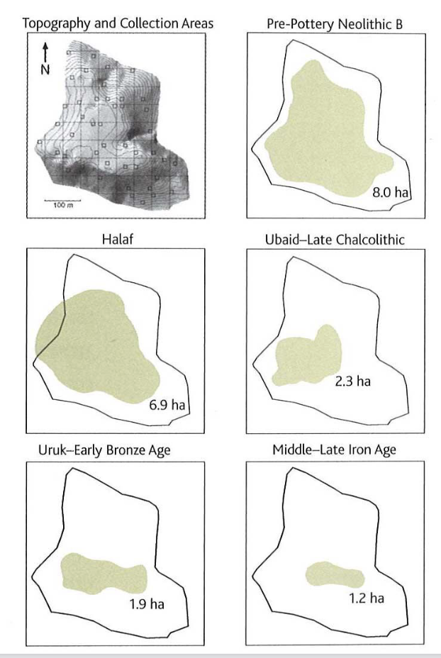
Tell Halula, Syria
- Example of site surveys – looking a site, not a region - Survey carried out in 1986 – found surface collection of potsherds, stone tools → validity questioned – various cultures has lived there, many processes over time that could have unearthed them - Used stratified random sampling procedures with a 4% coverage if 12.5 ha sites - Typological analysis: able to identify 10 major occupational phases → representing 15 cultural periods → able to determine each phase, while CORONA satellite images were used to define the boundaries of the Tell

Subsurface survey: augering
- Related to resistance probing – rod has a corkscrew shape where it is screwed into the ground - By turning: picks up a sample of the soil from the ground - This specific example: Petra Jordan → looking at a pool garden complex in central Petra, used RADAR that gave a map of anomalies beneath the ground → used augur to take probes in the garden areas – see soils of different lengths in the same hold going more than a metre down → analyse soil, pinpoint one depth that has soil with fertilisers that was consistent with the idea of an ancient garden → able to create a reconstruction of what the complex could have looked like

Example of the buildup of strata over time (stratigraphy of a post hole):
- Hole was dug, levelling stones put in, dirt was put back in around 1300
- Post decayed, new layers and the type of soil of each strata, these conclusions are able to be reached
- Potsherds found in soil layer and in the hole show that the two come from the same locus (law of association)

Ground penetrating radar (GPR):
- Looks for anomalies in radar pulses - Radio pulses are transmitted into the subsoil and bounce off objects back to the receiver, measuring how long it takes to return - Return sign signal = the depth of a buried feature or object - Time slice = isolate results for a certain depth - Used in Petra – differentiate between buried remains and soil - Time slices: radar depths are isolated, see remains of roads right beneath the soil, the building buried under the roads (walls, floor, objects on the floor)

Examples from Humayma
- Use standard features of a Roman fort as a reference - Use GPT (yellow) - Electrical resistivity recorder - Magnetometry device - Survey in a grid – systematic approach
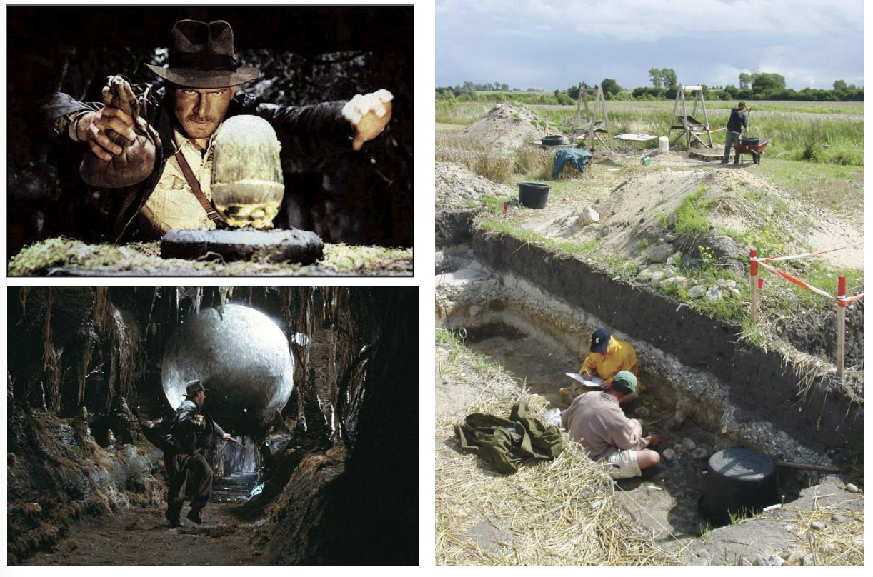
Conduct on sites, specifically regarding recording
Have to record everything about a scene
– layers of soil, what is found in each layer, ect
- Take copious notes as the context is destroyed when you begin to dig, so you have to be responsible and record
- Reflects 20th and 21st values about archaeology
– want to preserve as much about the past as possible
- In recording: have to publish findings to scholars and the world to know what has been found and done
- Many laws in place regarding conduct that have to be followed relating recording – → before leaving the country, the team must hand in objects, a report, and a press release


Accumulation of strata over time
- Sites abandoned over time and new settlements are built up on top of them
- Active layer is buried beneath sediment, a new site is built
- Follows to law that allows archaeologist to determine relative data and strata
→ law of association: artifacts and ecofacts found in the same stratum share a depositional history (when stratum was formed was when the objects were put there)
→ law of superposition: a stratum that wholly or partly overlies another was deposited later than it

Example of the buildup of strata over time (stratigraphy of a post hole):
Hole was dug, levelling stones put in, dirt was put back in around 1300
- Post decayed, new layers and the type of soil of each strata, these conclusions are able to be reached
- Potsherds found in soil layer and in the hole show that the two come from the same locus (law of association)
Main idea: these are professional standards that are in place to ensure all modern archaeologists are acting appropriately in all aspects - Archaeologist have to adhere to the highest standards of ethical and responsible behaviours - Have a responsibility for the conservation of archaeological heritage - Work in a way that reliable information about the past can be acquired and all the results are properly recorded - Make the results available - Recognize aspiration of employees, colleagues, and helpers in terms to employment, health and safety, equality, ect - Relates to 20th 21th century ideas → records everything to ensure preservation of history

Stages of an Archeological Project
- 1. Fieldwork (excavation, recording, removal of finds) -
2. Analysis of what was excavated (all artifacts and ecofacts, loci strata) -
3. Phasing: look at what times in history of the site the particular layers built up -
4. Comprehensive research -
5. Scholarly publications, public display, archiving data: archiving field notes and analysis so someone in the future could look at it and verity or further information → some governments require the achieving of data one the excavation is finished

Fieldwork teams and the members
- Project directors: does pre-reconnaissance, knows overall plans and jobs for workers - Area and procedure supervisors
- Excavators: most of the people on the project
- Photographer: takes pictures that are quality for publishing
- Architect: draws top plans and section drawing → can be students – less money and allows them to learn
- Conservators: trained to stabilise objects once they have come out of the ground
- Ceramicist: Greek and Roman sites and mostly made up of broken pottery
- Administrative: makes sure things run smoothly (vehicles run, tools are fixed, food and water, manages salaries, is liaison to local communities)

Grid-square method to find horizontal units to excavate
- Put a grid across the entire site and excavate systematically cross the entire site
- Invented by Sir Mortinmer Wheeler
- advantages: → systematic and precise excavation, each unit equally treated → Baulks provide good record of stratigraphy → Many discrete excavation units allow soil and contents to be studied across the entire site
- disadvantages: → don't know what in the baulks → Takes time to fully excavate → will have many boxes without artefacts – makes it hard to see the big picture → lots of wasted material

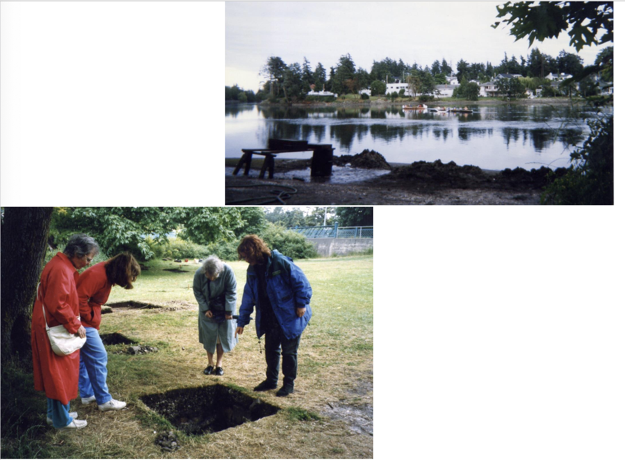
Judgement based sampling in Victoria, BC, Virginia USA, and Manchester UK
- Put small squares to be excavated throughout the park where they wanted to build a concrete path
- Example of sectioning: some of the squares were excavated only half to be able to see the stratigraphy of the area
- Able to see that it was a shellfish harvesting site to had been used for millennia by indigenous peoples

Setting up the square (box-trenches)
Requirements: at particular places on a grid laid over a site, have square/right angled edges - Technique one: survey equipment: → total station and reflector → advantages: can set up straight lines using beams → disadvantages: have to ensure scope is level, have to have space and money for equipment, have to have a clean line of site from beam, takes a while - Technique 2: pythagorean theorem → use a2+b2=c2, using equations with number 3,4 to generate triangles with right angles → use survey equipment to put first square in, then use this for the rest (have pre-established baseline) → advantages: can be done quickly and easily → disadvantages: cloth messing tapes can stretch and wrap around measurements

Strategies for setting excavation loci
- How to create vertical layers for excavation – have method chosen by field director and carried out by excavators - Four strategies to identify loci vs. strata 1. Natural levels: loci overlap beginning and end of strata, use when you can see the natural layers of strata 2. Contoured arbitrary levels: when the strata slopes, so archaeologist dig on a slope and approximate natural layers → use when you can’t see natural strata 3. Simple arbitrary levels: dig straight down in consistent intervals → used when you can’t see the natural strata, has many problems associated with it, can mix up strata 4. Combo of Natural and Arbitrary levels: follows layers when they can be seen, but create arbitrary layers when natural layers can’t be seen

Tools and strategy for excavation:
- Image 1: tools for digging: big picks (used to disturb ground and collect artifacts/ecofacts using flat edge), hoe, sifting for finds → Other tools: small picks and trowels (flat archaeologist’s trowels) → Dental tools and small paint brushes - Image 2: taking artifacts out; use dustpans, hoes, shovels, wheelbarrows, bin/buckets → each loci has its own bucket - Image 3: cleaning the baulks: use small paint brushes (whisks brush to move first and nylon brush to get fine sediment off) → have to clean baulks to keep the vertically straight → get all extra sediment out of the box

Feature registration from Humayma survey looking at petroglyphs and quarries
A way of recording finds, mainly features found in an excavation - On this dig: looking at hills and ridges to find activity areas used by the people of the past - Record information about the land masses and sites on the land masses that were focused on - Record things like physical appearances of the land, the direction it faces, dimensions, the features surrounding it , what can be seen from it, ect → tailored to the specific dig
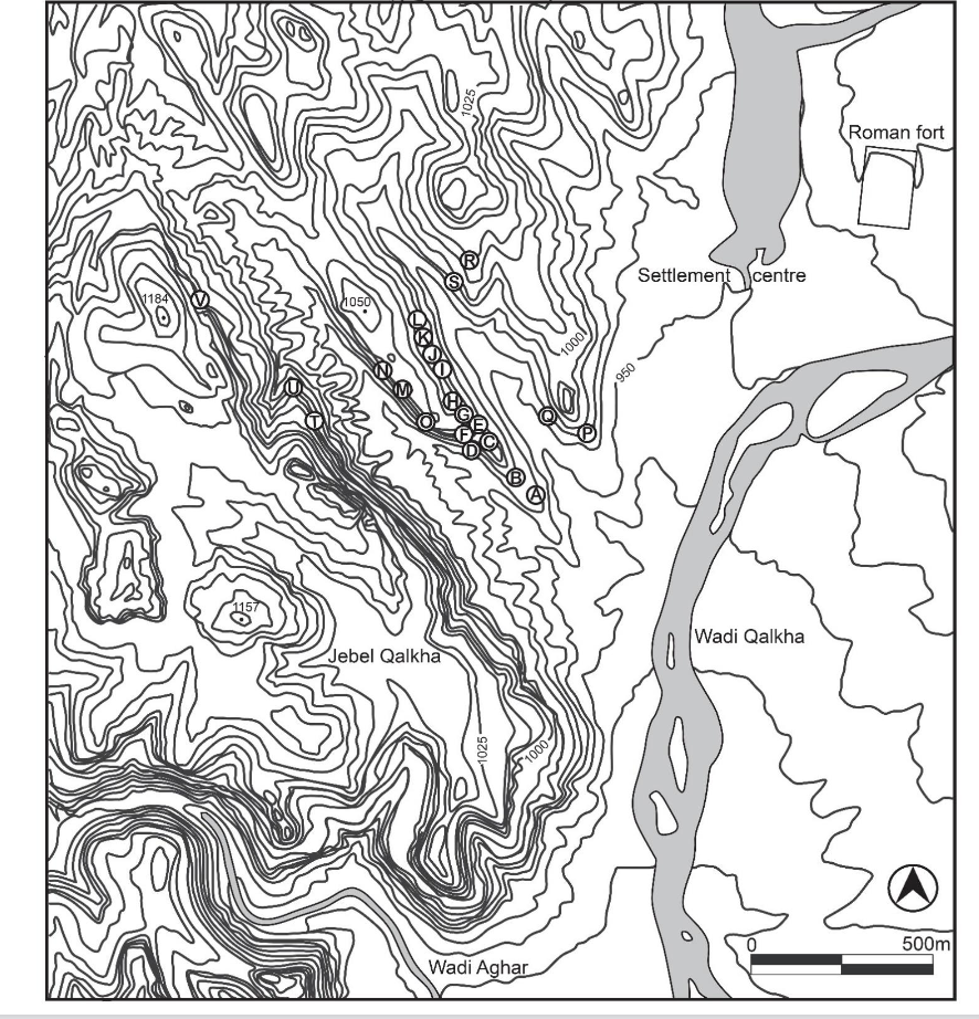
Maps of the sites recorded in Humayma
On an excavation looking at petroglyphs and quarries to explore hills and ridges and find activity areas used by past people - Conducted a survey along ridge two, side of ridge 1, and side of Jebel Qalkha facing ridge 2 - pre-reconnaissance : found a petroglyphs of a Roman religious ceremony in the area on a past excavation → peak 2 was depicted in the original source, so there was a focus on it → wanted to understand the significance of the ridges and notched peak - Found 22 sites to record and labelled A-V on a site plan
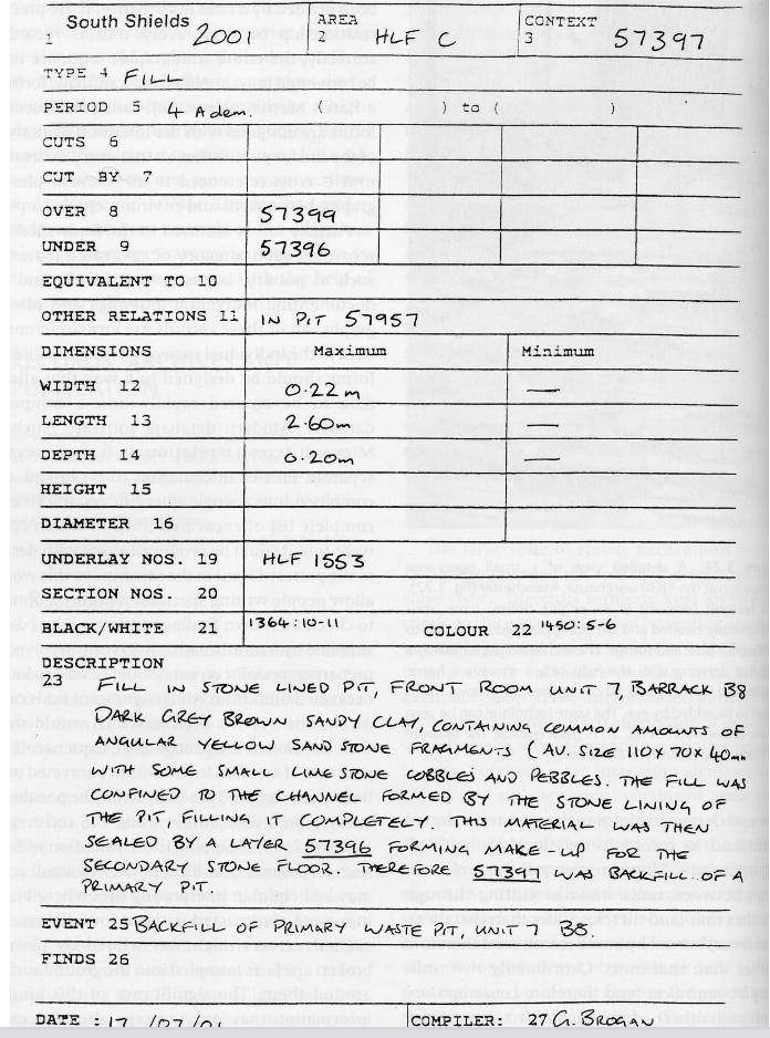
Excavation locus sheet (context sheet)
Provides a good record of location, nature, and contents of each locus - Shows where to look for additional information - Has a written excavation of each locus that was excavated - Records everything that was done, observed, interpreted for each locus - Contains: → site, year of excavation, area, locus/context → loci above and below → dimensions of locus → photos and drawings – where to find them → finds → precise date → team member who compiled the area - Has a description section → summary of whole locus - On the back: write how the locus was excavated (tools used, technique and strategy, ect) - Essential record of the locus from the team excavation and analysing the site

Munsell colour chart
Way of creating standardised language for the description of colours - Booklet of titles sorted in terms of 3 variables: hue, value, and chroma → hue: principle colour divisions → value: lightness or darkness → chroma: saturation - Each tile has a distinct code (e.g. 10YR ¾) and name a label (e.g. reddish brown) - Can be used to describe soil (has hole to easily compare each soil sample of the colours)

Soil texture triangle and rub test
- Soil texture triangle: a triangular chart with % sand on one axis and % clay on the other axis → use soil particle separation to see the makeup of soil: take a sample of soil and put it in a bottle of water with detergent and leave it overnight → the layers separate, allowing archaeologist to see how much of each materials is present in the sand → have names associated with each ratio and sand:clay - easier/faster way to find type of soil: rub test → take soil and drop of water and rub it between your fingers → have standardised of the soil consistency (e.g. almost pure clay is smooth and greasy, plastic, rolls into a wire)

Top plan
- One of two types of drawings of a sire - Top down view that shows the key fixtures and measurements of a grid - Shows type of sand and colour features – uses standardised descriptions - Has a key containing the site name, location of square is, locus of the square who is excavated/dew it, date - Key types of features (e.g. rocks and bone) - Scale Information about where notes and photos are - Shows vertical location of locus – measures at various locations that show DBD (depth below datum), measure with theodolite and stadia rod and sea leve
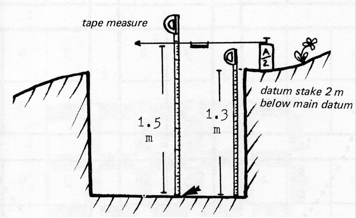
Way of measuring height of loci
- One way to create measurements (DBD) for the loci is to use a theodolite and stadia rod - Pre-record the height of a datum and use a tape measure, string, and line level to measure the subsequent layers as the square is dug into

Drawing top-plans with a drawing square
- Way to make top-plans easier to draw and standardised drawings - Have a grid (usually 1m square) that is broken down into 10 cm x 10 dm squares - Go square by square to draw the features of a site

Pedestaling and sectioning features
- Pedestaling: when you decide to leave a feature, like a dead body, and dig around it on either side to leave the object in place - Sectioning: cut section of different sizes to be able to see stratigraphy of key parts of a square → section goes through key features to see their stratigraphy → dig things different depths in different sections of a square

Different excavation methods
- Shows to different ways to excavate a walls: go straight through it or dig two trenches on either side of the wall - Consequences of going on either side of the wall: lose a lot of the stratigraphy of the site that gave information → able to see the collapse from the wall and how they differ on the North vs. South side → can come to conclusions about the use of the site and how it changed over time → some loci are not seen to well – not really able to see road 3 on the second image Very different record retained in section drawing, erases key fixtures like the post holes or the foundation trench → limited info about things like the road and what fell on each side → still have info about the loci, but is harder to interpret how it fits together and the history of the site

Drawing the cross section of a baulk
- Set up a horizontal line (string) across and use a line level to ensure its is level - Create a vertical axis using a plumb bob (heavy object on a string) - Go along the string at regular intervals (e.g. every 10 cm), using the plumb bob to ensure the tape measure it vertical - 2-person job: take measurements of the location of the visible strata and gives the measurements to someone to put them on a graph paper → connect dots to create drawings of the strata

Drawing on photographs for top-plans
- A way to save time while in the field-time consuming to create drawings - Take a photo of the excavated layer, print it out, and label it - Digital top plans vs. drawn top plans: measurements are more obvious in drawn ones, photos can have distortion due to camera angles → can use photos in field notes, but need drawings for publication - This image: parts of a series of different loci as the archaeologists dig down - Contains information like: → site area. Square number, locus (shows various loci – 01T, 02T, 00B) Numbers of adjacent squares Length of each side of the squares Elevations Baulks Key fixtures like rocks

Cleaning baulks for taking images
- To take photos, all stones and fixtures have to be clean to see all features - Go in with brushes (whisk and nylon brushes) - Make baulks straight - Ensure nothing is obscured by dirt in the photos - take all dirt to the dump site All excavation in the square and surrounding squares has to stop while the photos are being taken to ensure nothing impacts the photographs

Photographing finds
- For photographs: want to be as high as possible to have a vertical angle - Photos should contain an arrow indicating N/S, a scale stick, and some have a mug board that indicates what the photo is - In most cases: get as high as possible on a ladder to take the photo → two person job: have one person on the ladder and one holding/supporting – soil is soft and could shift or collapse under the ladder, have to be SAFE
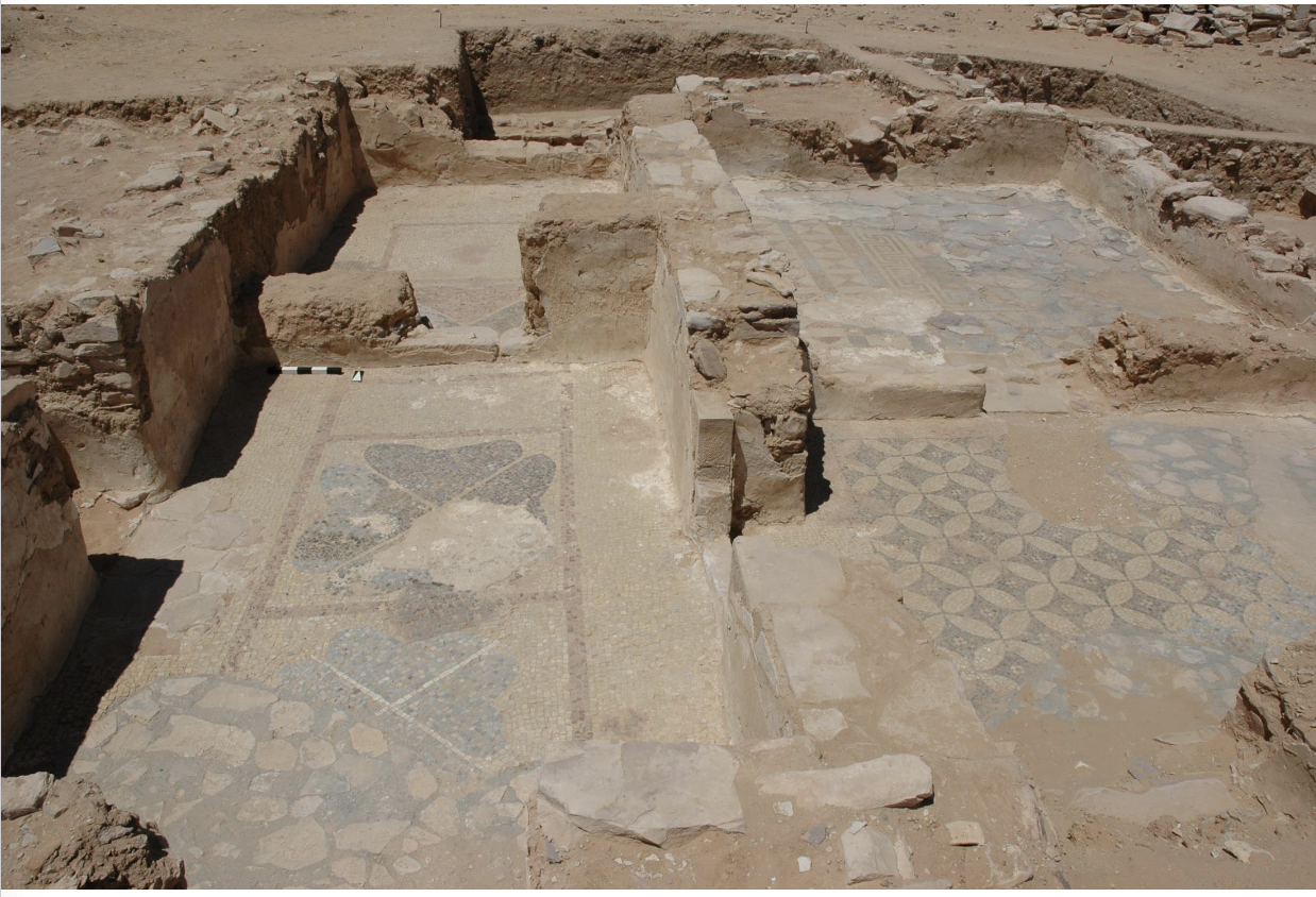
Photo of a finished square
- Contains scale stick, arrow indicating North - Challenges with lighting: has to be menial shadows → ways to get rid of shadows: ideal ways is to take photos at high noon, but poses many challenges (many people need to take photos in a small amount of time, have to stop excavation to take photos) → keep colours natural, minimising shadows - This image: shows the tiled floors, background shows a heated room

Recording finds from each locus
- Similar to requirements for recording excavation – record EVERYTHING - Many countries (like Jordan) don’t let objects can’t be brought with - Recording process: → go through all finds in the bucket (one bucket for each locus) → write a description of what's in there, then bring the bucket to the dig house where all objects are recorded in more detail → gather information like materials, period, weight, where it was found, ect → for broken objects: may have a glass or pottery expert come and study them → more complete objects: do more recording and have a ceramicist provide more information

Description of a vase found in Humayma
- Has a more detailed description accompanied by a professional photo - Description contains key information like the estimated culture and period is was from, a physical description of its looks (shapes and components), munsell colour, height/other measurements, weight, date excavated, area/square/locus

Photographing objects
- Requirements for photos: use a diffuser to avoid shadows → use a scale stick in cm and reference numbers (years and bucket number) → keep objects in natural orientations → have a neutral background colour that is relatively consistent between photos → have limited shadows so they don’t interfere with the interpretation → have even focus - These images: → wall plaster with illegible Greek inscription → coins with head side up → iron objects (iron link, stylus for writing on wax tablet, hobnail) → pendant out of bronze

Drawing objects
- Have trained members of the team draw unusual or complicated shapes - For more simpler or easier shapes, all team members draw their finds - Way to draw: → set up vertical and horizontal axis measure according to axis measure in on the object form the axis to make points on graph paper, then connect the point to finish the drawing - For things like ceramics: show both cross section and the outside (split drawing in two)

Drawing vs. photography
- Photos and drawing showcase different things of an object and work together to get as much information as possible - The object (a bronze pendant): the photo helps give colour, corrosion, while the drawing gives a better sense of details (things that can’t be seen in the photos, like how it is made of point of bent metal and has little knobs) → allows for a hypothesis to be developed – thought that this pendant could be stylised representation of a woman or that is resembles bangles associated with Roman horse trappings
Ise library and archives work – look at newspaper articles, historical documents about shipwrecks - Consult with local sailors, divers → have vast knowledge about their experiences in the area - Indigenous people - know oral histories Visible sites in shallow or clear waters (e.g. King Herod’s Harbor) - Visible anomalies in satellite imagery - Artifacts washing ashore (like Italian amphorae washing ashore in Mylos Hormos from a shipwreck in Red Sea) - Geophysical underwater survey techniques: → RADAR → magnetometers → side-scan sonar → sub-bottom profiling

Example of how different survey techniques are combined to find sites
- Is a radar image of one of the boats from the Franklin Expedition ships - Background: in 1840’s, two ships were trying to find North-west passage and ships became encased in ice and the crew abandoned and tried to walk home - Pre-reconnaissance: documents in 1859 provide information on shipwrecks and crew’s plan (latitude and longitude, talks of crew’s plan to walk out of the arctic) → found artifacts and graves associated with the crew and their expedition back from the ship → indigenous oral histories about what happened on the ship - Used radar images showing the ships in the arctic water – multiple times in multiple areas to try and find the boats → the two boats were found in 2014 and 2016
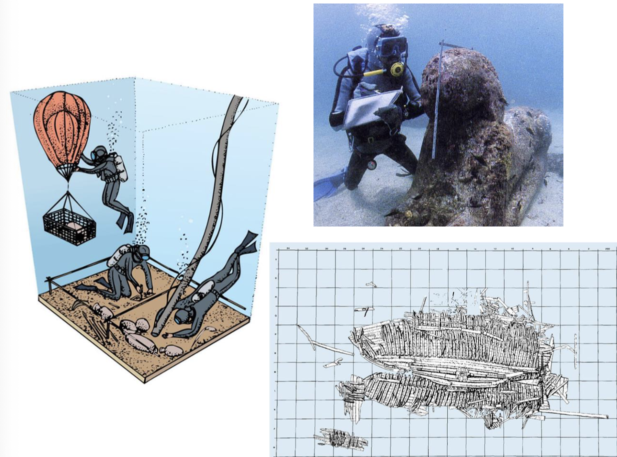
Drawing underwater and keeping consistency
- Drawings (site) are done similarly to drawings on land – use tape measure, plumb bob, find elevation - Object drawings are done similarly – create vertical and horizontal axis to draw profile, use waterproof drawing paper - During inderater dives: a lot of cycling excavators, as people can only be underwater for a certain amount of time for safety → put permanent numbers on finds to keep recording consistent between multiple excavators
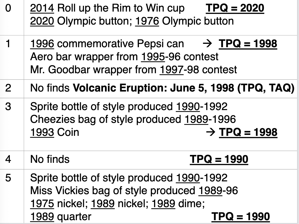
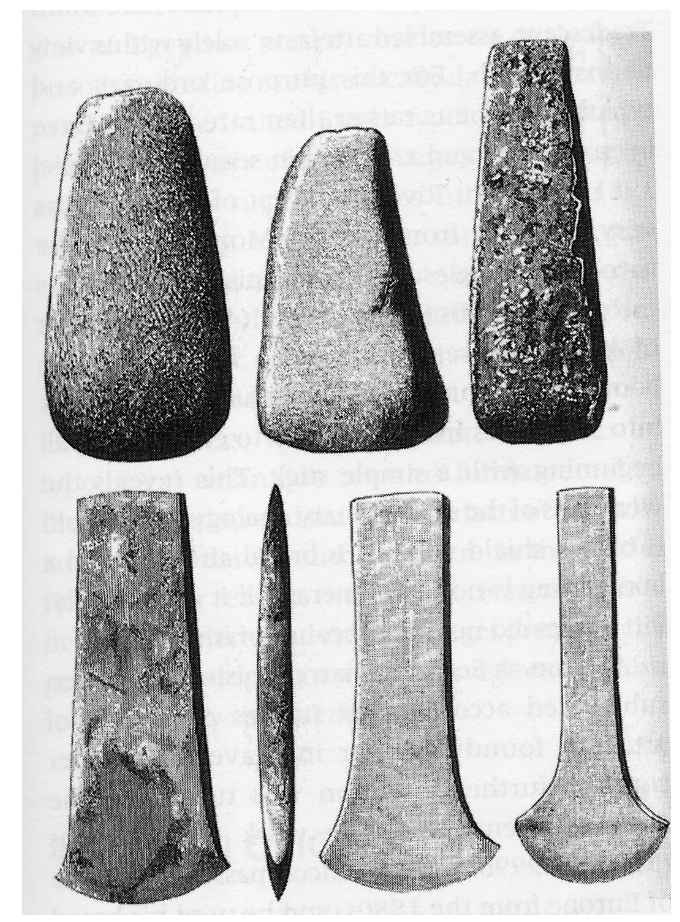
Typology- Dating technique. The systematic organization of artifacts into types because of their shared attributes. A type of relative dating.
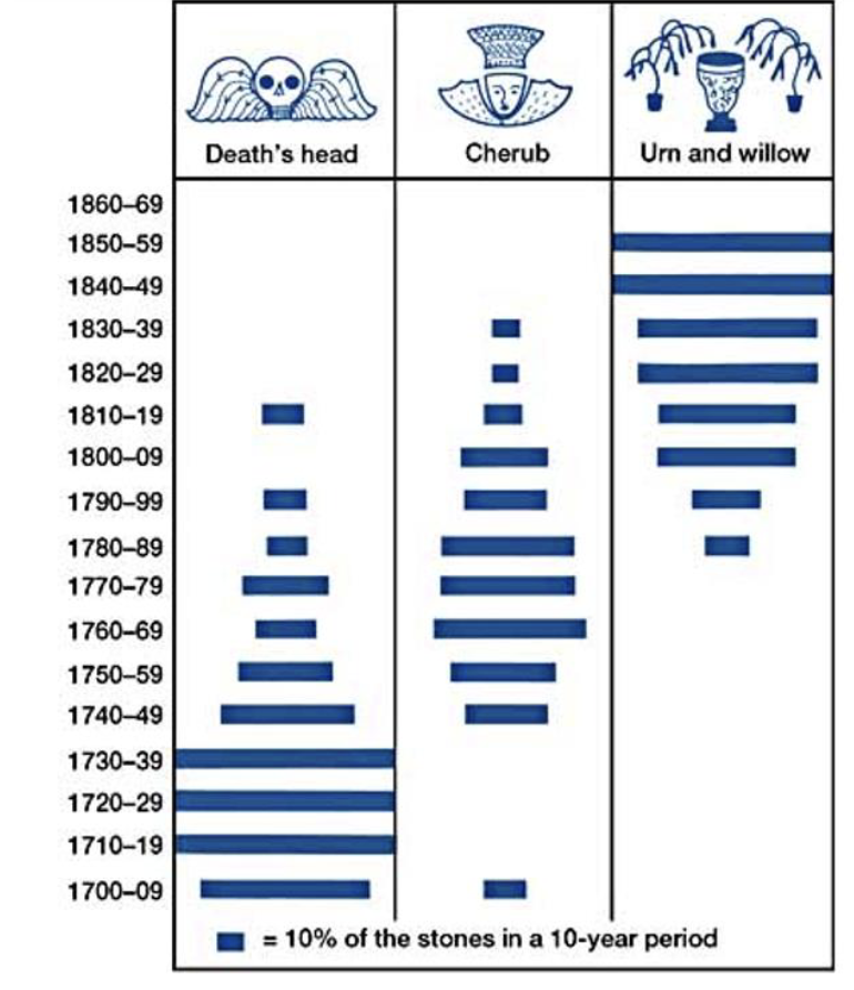
Frequency seriation. Measuring changes in the porpotional abundance frequency. A relative dating technique chronologically ordering a group of artifacts.

Ice cores. Frozen ice cores from permanently frozen regions of the atlantic. Layers depict annual accumulation of snow. Ice layers provide relative dating of years.