Oceanography Exam #2
 Call Kai
 Learn
Learn Practice Test
 Spaced Repetition
 Match
Match Flashcards
 Knowt Play
1/82

There's no tags or description
Looks like no tags are added yet.
Name | Mastery | Learn | Test | Matching | Spaced | Call with Kai | Chat |
|---|
No analytics yet
Send a link to your students to track their progress
83 Terms
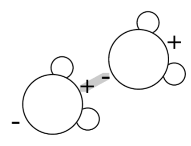
structure of the water molecule
2 hydrogen atoms
1 oxygen atom
shape “mickey mouse”
how is the water molecule held together?
strong covalent bonds — electrons shared between atoms

how is the electrical charge distributed in a water molecule? what is this structure called?
asymmetrical distribution of electrical charge — H end more positive, O end more negative
dipolar structure

what is responsible for the many properties of water?
dipolar structure of the water molecule & formation of hydrogen bonds between molecules
hydrogen bonds
relatively weak electrostatic forces between oppositely charged ends of adjacent water molecules
3 states of water
solid (ice)
less dense crystalline structure
liquid (water)
more dense than ice; surface tension
gas (vapor)
high energy molecules w/ few h-bonds
properties of water
occurs in 3 states
high surface tension
good solvent
dipolar structure weakens attraction between other molecules
high heat capacity
absorbs and releases considerable amt of heat (sensible heat and latent heat) w/ little change in temperature
sensible heat
vibration of water molecules, the temperature measured with a thermometer
how is heat measured?
calories
1 cal = amt needed to raise temp of 1g water by 1deg Celsius
latent heat
the heat/energy required to change water phase without a change of temperature
extra head involved in phase change due to breaking or forming h-bonds
what is required to break hydrogen bonds when ice melts and when water evaporates? how much?
heat energy
ice melting — 80cal/g
water evaporating — 540cal/g
hydrologic cycle
(evaporation-precipitation) redistributes heat around the planet by cycling water due to evaporation and precipitation
a process of the troposphere
how does the earth stay habitable?
hydrologic cycle → heat removed from the ocean in one area and released into the atmosphere somewhere else keeps earth habitable and more evenly warmed
evaporation
latent heat removed from the ocean
condensation and precipitation
latent heat released to the atmosphere
sublimation
phase change from solid to vapor
deposition
phase change directly from vapor to solid
why are tropical cyclones “mother nature’s safety valve?”
redistribute excess heat out that builds up in the tropics and subtropics to the higher latitudes
substances dissolved in seawater
gases (like o2 and Co2)
nutrients (like nitrates, phosphates, trace elements, vitamins)
organic molecules
mineral salts (like Cl-, Na+, SO4²-, Mg2+)
salinity
total dissolved solids
average ocean salinity
35‰ (units = parts per thousand → 3.5%
how does ocean salinity vary depending on environmental factors?
lower in areas of high precipitation (P>E) or high river runoff from the land
higher in areas of high evaporation (E>P) → subtropics; desert
how many naturally occurring elements are dissolved in seawater?
all of them: 6 ions account for 99.4% of all dissolved solids in seawater (Cl-, Na+, SO4²-, Mg2+, Ca2+, and K+); Cl- & Na+ account for ~85%
methods to measure salinity
measure chlorinity by titration
measure electrical conductivity using conductivity/salinometer
evaporate a known volume of seawater and measure mass of salts (solids) left behind
where do the dissolved “salts” in seawater come from? (input)
chemical weathering of rocks, runoff from the land
volcanic emissions
hydrothermal activity on the seafloor (e.g. at spreading centers)
fluids generated at subduction zones/accretionary prisms (above trenches)
has the chemical composition of the ocean remained constant over time? why?
yes; because input = output
biogeochemical and geochemical cycles are very important in maintaining ocean chemistry steady state! important for the evolution of life
sink for “salts” (output)
biological recycling (skeletons & shells, plus biological productivity) marine sediments
burial in sediments
ionic exchange between superheated seawater & oceanic crust at the spreading centers
subduction (recycling of crust & sediments)
4 major types of marine sediments
terrigenous
abyssal red clay & authigenic deposits
calcareous ooze
siliceous
terrigenous sediments
(sand, mud) derived from the erosion & weathering of the land, transported to the sea by rivers, ice, and wind. masks other sediment types because of high accumulation rates
continental margins — high accumulation rates of sand and mud (mask other sediment types); turbidity currents move sediment
abyssal plains — slow accumulation of red clay; may be associated with authigenic iron-manganese (poly-metallic) nodules.
red clay
wind-blown dust & current transported clays
accumulates very slowly on the abyssal plains
funneled to deep sea with submarine canyons
calcareous ooze
derived from plankton with calcium carbonate shells (CaCO3) e.g. coccolithophorids and foraminifera
accumulates on bathymetric highs above the carbonate compensation depth/CCD (ridges, rises, flanks of volcanoes away from continental margins).
siliceous ooze
derived from plankton with siliceous hard parts (SiO2), e.g., diatoms and radiolarians.
Accumulates under areas of upwelling and high biological productivity (equator, around Antarctica and the Arctic)
turbidity currents
rip down submarine canyons creating huge submarine fans at base of continental slope; continental rise = thick wedge of sediments
authigenic deposits
precipitate directly from seawater under specific biochemical conditions (e.g. FeMn nodules)
hydrothermal activity at spreading centers “black smokers” → a major source of dissolved source of metal oxides
lower latitudes and solar radiation
tropical/subtropical areas receive a net gain of incoming solar radiation (insolation)
more solar radiation is received during daylight hours than is radiated back into space at night
high latitude and solar radiation
polar/subpolar regions experience net loss of mean annual insolation
experience months of total darkness or low sun angles → heat absorbed by the ocean and atmosphere is less than energy radiated back to space
how much redistribution of heat do the atmosphere and ocean share? due to what?
atmosphere — via hydrologic cycle: evaporation-precipitation (latent heat) and winds/weather) and ocean (via large ocean currents: subtropical gyres) share about equally in redistribution of heat from the low latitudes to the high latitudes
greenhouse effect
natural process where gases in Earth’s atmosphere trap heat from the sun, keeping the planet warm enough to support life/makes earth habitable for life
global warming. why?
magnitude of the warming and the rising rate of warming are of critical concern
due to ever increasing levels of anthropogenic greenhouse gas emissions
why does earth have seasons?
earth tilted at 23.5 degree angle relative to revolution around the sun
sun directly over tropic of cancer on N.H. summer solstice (earth tilted toward sun → more insolation)
sun directly over tropic of Capricorn on N.H. winter solstice (earth tilted away from sun → lower insolation)
equinox
occurs twice a year when everywhere on the planet receives 12 hours of daylight and 12 hours of darkness
fall and spring
what shape is earth’s orbit
nearly a circle; only slightly elliptical
how does the ocean transport heat? subtropical gyres?
by large surface currents
subtropical gyres are large circulation cells
warm waters move poleward along western sides of ocean basins
cool waters move equatorward along eastern sides of ocean basins
gulf stream
transports warm waters north and east
how does the atmosphere transport heat?
transports heat by way of hydrologic cycle
h-bonds broken during evaporation of water (latent heat removed from ocean 540 cal/g) → moisture rich air masses cool → condensation causes cloud formation and precipitation as h-bonds form (latent heat released to atmosphere)
highest noontime sun in Amherst (42.5 degN) at summer and winter solstice?
Highest noontime sun at summer solstice = 71deg above the horizon
highest noontime sun at winter solstice = 24deg
weather
day-to-day changes in the atmosphere
climate
seasonal progression of weather in a particular region and its year-to-year characteristics (including interannual variability)
relationship between atmospheric pressure and air masses?
low atmospheric = rising air masses
high = sinking air masses
prevailing winds. what directions do they blow?
Westerlies = west to east
Trade winds = east to west
polar easterlies
bands/zones on earth and relation to cloud formation
clouds = greater precipitation; P>E
precipitation → air masses rising → low atmospheric pressure
alternating with other zones displaying less clouds and greater precipitation = greater evaporation; E>P
evaporation → air masses sinking → high atmospheric pressure
what direction do hurricanes and typhoons travel and in what zones in the northern hemisphere? what causes this movement?
they move east to west in the tropics and then hook north and east as they move out
Coriolis effect — they come from east to west by the trade winds then hook around move west to east due to the westerlies
ITCZ (intertropical convergence zone)
where the winds come together and rise to form clouds in the tropics
marks the convergence of the NE trade winds and the SE trade winds
how many atmospheric circulation cells in each hemisphere? what are they? what move along the edges of the cells? how often do boundaries shift?
3 atmospheric circulation cells in each hemisphere defined by alternating low and high atmospheric pressure
polar cell
high latitudes; polar easterlies
Ferrel cell
mid latitudes; westerlies
hadley cell
low latitudes; NE trades
fast moving jets move along the edges of the circulation cells
boundaries shift daily and seasonally
the polar vortex
a rotating mass of cold arctic air. polar jet stream separates cold polar air (polar easterlies) from warm subtropical and temperate air (westerlies)
is the jet stream a straight line?
no; the jet stream is wavy and dynamic; big southward dips called troughs and northward waves called ridges
Coriolis effect
the deflection of air masses, water masses, airplanes, or missiles due to the rotation of the earth underneath
direction of Coriolis effect for northern and southern hemisphere
to the right in the northern hemisphere; deflection to the left in the southern hemisphere
where is the Coriolis effect strongest, and where is it weaker? why?
strongest at the poles and diminishes toward the equator where it changes sign from right to left
due to differences in the velocity of the Earth’s spherical surface as it rotates in space
where do air masses rise, and where do they fall?
air masses rise near the equator (L) and sink in the sub tropics (H)
near surface air masses are drawn south toward the equator but due to the rotation of the Earth, these air masses are deflected to the right in the N. Hem. (left in the S. Hem.) giving rise to the NE Trade Winds (SE Trade Winds).
what direction do storms turn in the northern hemisphere vs the southern hemisphere?
northern hemisphere → counterclockwise
southern hemisphere → clockwise
Coriolis effect in relation to the equator
no Coriolis effect at equator bc that’s where it changes signs. bc of this the air masses just rise, so there are no swirly clouds like there are in the mid-latitudes, just tall puffy ones
ocean salinity in relation to region/latitude
higher ocean salinity in subtropics and lower salinity in tropics and temperate regions (mid latitudes)
natural climate variability
seasonality
tropical cyclones
extra-tropical cyclones
monsoons
interannual variability
el nino southern oscillation (ENSO)
ocean heat waves
more frequent and longer lasting
el nino southern oscillation (ENSO)
triggered by a change in H to L pressure gradient across tropical pacific → affects the stregnth of the trade winds
normally strong trade winds pine up warmer water in western pacific. trade winds slacken?
→ warm pool slides east causing drought in SE Asia, heavy rain in Peru (and california), reduced upwelling off south america and affecting global climate patterns
el nino yrs = low biological productivity
monsoons
causes by seasonal movement of ICTZ and seasonal reversal of the winds resulting in dry season and wet season in affected tropical regions
effects of continued global warming on weather
greater extremes
increased precipitation in wet places and increased aridification — desertification — in dry places (deserts expanding)
west coast wildfires
ocean heat waves
becoming more frequent and warmer and have significant impact on marine ecosystems
rising surface temps breeding more intense hurricanes and typhoons
temp ranges depending on latitude
polar (high latitudes) — cold to very cold
temperate (mid-latitudes) — cool to warm
tropics (low latitudes) — warm to very warm
what heats ocean surface. what does this create?
solar energy heats surface waters in low to mid latitudes; net solar gain in tropics and subtropics
creates warm less dense surface layer over very cold and dense deep waters
permanent thermocline
the depth interval through which temperature decreases rapidly with increasing water depth
the step from warm surface waters to cold deep waters; the intervals of change
how can you measure the permanent thermocline?
CTD deployments
measure conductivity (salinity); how well electricity travels through water depends on the amt of ions in it. travel faster? → more ions → 85% seawater NaCl
mixed layer
surface-most part of ocean where temperature is vertical; thickness can vary by season
depth of the mixed layer
a function of mixing (homogenization) of the warmed surface waters by the day-to-day winds and storms, waves and surface currents
presence of permanent thermocline by latitude
polar waters (high latitudes) → very weak/no permanent thermocline
temperate waters (mid latitudes) → permanent thermocline present, w/ seasonal thermocline
tropical waters (low latitudes) → strong thermocline present
how is the world ocean structured? why?
well-stratified (layered) in the low-to-mid latitudes due to solar heating of surface waters and formation of permanent thermocline
permanent thermocline separates warm (less dense) surface waters from icy cold (denser) deep waters
seawater density controlled by?
seawater density is a function of temperature and salinity
pycnocline
layer of water in the ocean where seawater density increases rapidly by depth
presence of pycnocline by latitude
polar waters (high latitudes) → very weak/no permanent pycnocline
temperate waters (mid latitudes) → pycnocline present
tropical waters (low latitudes) → strong pycnocline
how does water become more dense?
cooling , sea-ice formation, evaporation
depth of the permanent thermocline?
100-1000 m deep. below 1000m is all icy cold
why are deep waters denser than surface waters?
deep waters originate on the surface, they just sink
they become more dense (in order to sink) by:
adding salt
cooling — the water molecules become more densely packed