Environmental Geomatics Final
 Call Kai
 Learn
 Practice Test
 Spaced Repetition
 Match
 Flashcards
 Knowt Play
1/606

There's no tags or description
Looks like no tags are added yet.
607 Terms
Geomatics
the science & practice of collectiong, storing, processing, analyzing, & presnting spatial information (data collected from a distance & understanding what is happening where)
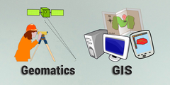
Geomatics is primarily focused on the application of what three technologies?
1.) Geogrpahic Information Systems (GIS)
2.) Remote Sensing (satellite imagery, aerial photographs, etc)
3.) Global Navigation Satellite (GNSS) --> GPS is an example of this
List in what ways geomatics can be used for
1.) Enviromental Planning/ Landscape Architecture
2.) Ecology
3.) Conservation Biology
4.) Agriculture
5.) Enviromental Science
6.) Physical Science
7.) Public Health
8.) Disaster Response
Geomatics has applications in almost any _____ field you can think of.
Field
Geomatics is all about __________ what is happening where.
understanding
Spatial Entities
places, things, events, & conditions that occur at specific locations or over specific spatial extents

Feature Geometry
concept of spatial entities divides space into dicrete points, lines, & areas based on the extents of individual conditions
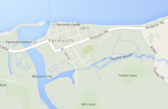
Points
Individual locations of places, things, or events for which the extent is not relevant at a given scale

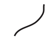
Lines
Features with long and narrow extent for which the length is relevant at a given scale, but the width isn't
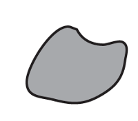
Areas
Features or places that have a two-dimensional extent, which is relevant at a given scale
In geomatics, we think of spatial entities in terms of ________ spatial structures.
primitive
Grid Cells
concept of spatial entities divides space into a set of ordered units (cells), each with the same size & shape

Grids
A depiction of an area of some spatial extent as a set of ordered units, each with the same size and shape

Cell
Individual units composing a grid; each cell is independent of all other cells, regardless of their contents

Landscape Mosaic
conceives of the composition of an area as a mosaic of more or less discrete patches where certain conditions are met (specific vegatation communities, species habitat, etc)
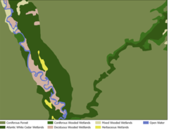
Patches
Discrete areas considered to be homogenous in some
biophysical characteristic; may vary dramatically in size and shape

Corridors
Relatively long narrow patches that an agent may move through; typically connect two or more sizable patches.

Matrix
An area into which distinct patches are embedded; often not a homogenous area but made of patches of various types

What five key elements of a city image was described by Kevin Lynch?
1.) Paths
2.) Edges
3.) Districts
4.) Nodes
5.) Landmarks

Paths
The routes by which agents frequently or potentially move through the environment

Edges
Linear elements not used as paths; may define boundaries or obstruct movement

Districts
Distinct areas of medium to large size that agents can enter and move inside of.
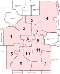
Nodes
Strategic points that an agent may enter; often the intersection of paths
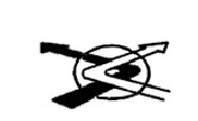
Landmarks
Points of reference into which an agent does not enter

Spatial Relationships
specifies how some object is located in space in relation to some reference object

Adjaceny
decribes the condition of one entity being near to or touching another

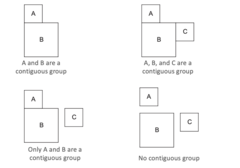
Contiguity
describes the condition of multiple features being connected through shared edges or boundaries
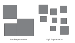
Fragmentation
decribes the degree to which entities present as small, disconnected features
Connectivity
decribes how things are connected, either directly or through some intermediary

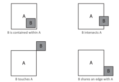
Topology
decribes certain relationships among features without reference to specific shapes, areas, or distances
Proximity/ Distance
decribes how close one entity is to another

Spatial Distribution
space between entities
What are the four types of spatial distribution?
1.) Dispersed
2.) Clustered
3.) Random
4.) Gradated
Dispersed

Clustered

Random

Gradated

Homogeneity & heterogeneity describe how much ________ thre is in conditions across the area of interest.
variation

Diversity
measures how many different types or conditions are found in an area

Which shows greater diversity?
A

Some measures of diviersity consider only the ________ of types or conditons present (ex: species richness).
number

Some measures also consider how ______ each type or conditon is relative to others (ex: Shannon Diversity Index).
prevalent (widespread)

Spatial Correlation
describes the situation where specific types or conditions are found in the same location or close proximity—and how frequently this occurs.

Is there a spatial correlation between contaminated sites & any specific land use?
Industrial & Commercial

Spatial Autocorrelation
describes the situation where entities of the same type or similar condition are found in the same location or close proximity—and how frequently this occurs.

Maps
an illustration of land or other geografic, political, or historical features

Mucg of what we understand about how maps communicate spatial information was described by ___________ ________, in 1976.
Jacques Bertin
Most common representations of data plot values along two ______________ axes.
perpendicular
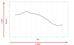
The values that maps plot on these axes are the ____________ of those features' location.
coordinates

Map Symbols
Graphic elements that help organize the information in a map, such as (but not limited to) dots, stars, arrows, squares, and dotted lines

What six useful ways to modify the apearance of marks that represent map features identified by Bertin?
1.) Size
2.) Value
3.) Color
4.) Shape
5.) Orientation
6.) Texture
Size
how big or small something is

Value
how light or dark a given mark is

Color

Shape

Orientation
the direction of a mark or marks that represent a feature

Texture
The feel, appearance, or consistency of a surface
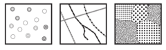
Different variables are best for different types of attribute values, what are each of them?

Map Surrounds
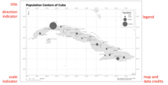
additional elements to help interpret symbols & provide context
Basemaps
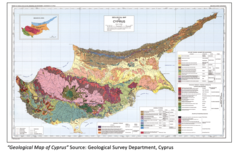
Maps depicting background reference information, such as landforms, roads, landmarks, political boundaries, or satellite imagery, onto which other thematic information is placed.
What are the two types of maps?
Reference & Thematic Maps
Reference Maps
focus on the locations of different types of features in the landscape (include atlas pages, road maps, topographic maps, etc. & may be used as basemaps to provide context for thematic maps

What are the two types of reference maps?
political & topgraphic maps
Political Maps
reference maps that emphaize politcal boundaries & major settlements

Topographic Maps
genreal puprose reference maps that show key landscape features with high locational accuracy
Thematic Maps
focus on depicting a single phenomenon or set of conditons (may include single data thems ,such as flood zones, or a combination of interacting data themes, such as floods zones & acess to emergency services)

Thematic maps may show either _________ or ________ information.
categorical or statistical
Thematic maps of __________ data typically vary the color, shape, or texture of features to visually identify the feature's category.
categorical
Thematic maps of __________ data usually vary the value of the fill color or the size of the feature to reflect some numerical value associated with the feature.
statistical

What are the two other types of maps?
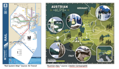
Schematic (simplify spatial relationships) & Pictorial (focus on aesthetic representation) maps
Choropleth Map
A thematic map that is common, but uniquely tricky technique for mapping statistical data

The relative value of a given area, the feature is represented by its position along a ______-__-_______ gradient
light-to-dark

Data values should be _________ to account for different sizes of individual features.
normalized

Normalizing
dividing the measured value by either area of the feature (ex: density) or by the highest possible value for that feature (ex: the # of people under 18 divided by the total population)
Why would it be important to normalize the fata in a choropeth map?
it avoids the phenomenon we are interest in with other variables

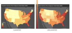
Values are generally __________ for visual clarity, each shape means indicates a value range & not a specific #.
classified
For a choropleth map, what are the three different classification methods that place the same values into different classes (ways to classify data)?
equal interval, quantile, & natural breaks
Equal Interval
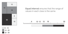
Quantile

Natural Breaks

Why do we make maps?
Like all data visualization, the end goal is not to display data, it is to gain insight through interpreting the patterns we find in the data (derive & communicate information about a place or spatial phenomenon)

Maps use basic visual elemnts (points, lines, areas, & gradients) modified in different ways to _________ real-world features & their attributes.
symbolize
Coordinate Systems
indicate a location on the Earth's surface as the distance of that location east & north of some arbitrary origin point

Sphereical Coordinate Systems
identify a location on the curved surface of a sphere (or ellipsoid)
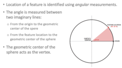
Sphereical coordinate systems generally set the _______ to the intersection of the Equator & the Prime Meridian.
orgin
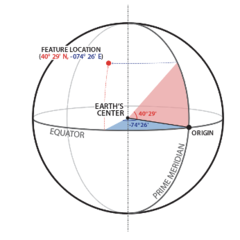
Latitude
distance north or south of the Equator, measured in degrees

Longitude
distance east or west of the prime meridian, measured in degrees

Grid Coordinate Systems
identify a location on a flat surface (ex: map)

A grid coordinate system may set the origin to ________ ________ on the Earth's surface.
any location

Graticule Grid
a network of lines representing longitude (meridians) & latitude (parallels), on which a map or plan can be represented

For grid coordinate systems, ___________ grids show linear distances from the orgin across the X & Y axes.
measured
The general shape of the Earth is an oblate spheroid, also known an ___________.
ellipsoid
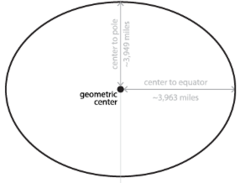
Dips & bulges in the Earth's shape result in a complex shape called a _________.
geoid (caused by variations in the denisty of the Earth's crust)

Datums
mathematically dervied estimates of the true shape of the Earth's ellipsoid

A datum is calculated by creating a best-fit curve through a set of ________ _______, whose locations are known with a high degree of accuracy.
control points

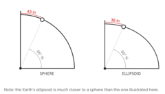
Why does understanding the Earth's slightly non-spherical shape matter?
a given latitude will point to different locations on different ellipsoids
Map Projections
algorithms that mathematically account for distortions that occur in the process of projectiong a 3D curved surface to a 2D flat surface
Tissot's Indicatrix
circles used to visualize distortions due to map projection. These circles are equal in area before projection, but distorted afterwards
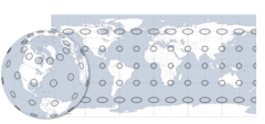
What are the four basic characteristics of spatial entities & their spatial relationships that projections distort?
shape, area, direction, & distance
Plate Carree Projection
provides no compensation for shape or area distortion
