GEO 155 TEST 3
 Call Kai
 Learn
 Practice Test
 Spaced Repetition
 Match
 Flashcards
 Knowt Play
1/69

There's no tags or description
Looks like no tags are added yet.
70 Terms
tropics differ from the rest of the world for two reasons
solar energy is similar through the year and across the region
the Coriolis effect is weak
The weather of the middle latitudes comes from
Coriolis effect combined with the change in temperature between the equator and the poles
temperature gradient
rate at which temperature changes, here with latitude. It is largest in the middle latitudes.
Differences in temperature produce
differences in pressure
equator-to-pole temperature gradient is what starts the winds
start winds = coliolis turns
greatest at winter
jet stream
band of strong winds at high altitude
created by the equator-to-pole temperature gradient
thats why flying from LA to NYC takes less time, west to east
fastest happens at 30 N
One knota
little more than one mile per hour. 100 knots is about 115 miles per hour
jet stream during different temps
temperature gradient produces differences in pressure at a given height
warm air = high column
DIFFERNECE WITH TEMP = SAME PRESSURE
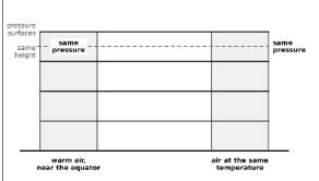
jet stream with difference in temp
warm goes to cold at the poles
A difference in temperature makes a difference in column height, which makes a difference in pressure at a given height.
colioris moves from west to east
A stronger temperature gradient makes a stronger pressure gradient, and a stronger pressure gradient makes stronger winds.

hadley cells
30°N - deserts, dry air
20 N - ITCZ , storms
subtropical jets
formed by jet stream
strong winds
found at hadley cell
he temperature gradient makes a pressure gradient, which makes west-to-east winds high in the troposphere.
straight
polar-front jets
boundary between warmer air in the middle latitudes and colder air farther north
50-60 N
he temperature gradient makes a pressure gradient, which makes west-to-east winds high in the troposphere.
wavy shape
hot and cold air
balance each other out , depends on the lattitude
geostrophic winds
middle latitudes the stronger Coriolis effect
do the same job as hadley cells - turn hot and cold
strength of the Coriolis effect
the Hadley cell or pressure systems carry the heat: weak in the tropics, stronger in the middle latitudes.
energy at hadley cells
carries energy away from the tropics at 30 N - 30 S
Highs and lows pick it up there and carry it farther north.
Intertropical Convergence Zone
trade winds from the equator
Air then flows away from the equator to the north and south, sinks near 30°, and flows back toward the equator.
heaviest rains
The ITCZ follows the latitude where the sun is strongest,
If Earth did not rotate
air would simply move from the tropics to the poles, with no highs and lows and a much simpler pattern of winds.
circulation
how solar energy is spread over the planet, and Earth's rotation.
winds exist because of
temperature difference between the equator and the pole, combined with the change in the Coriolis effect with latitude.
tropics
solar energy is fairly constant through the year, so most of the tropics have a wet and a dry season instead of a winter and a summer.
the Coriolis effect is weak in the tropics. This is the main reason the tropics are different.
average temp is 70
planet and energy
not in balance , causes global warming
more energy is at the equator
less energy is at towards the pole
42 degrees is the goldilocsk
energy is carried by
the atmosphere, through the winds, and the ocean, through currents
Absolute humidity
the actual amount of water vapor in the air. It can be measured
always less than or equal to saturation humidity.
changed by weather systems bring in moister or drier air
grams cubic square
as air rises - AH doesnt change. water stays
Saturation humidity
maximum amount of water vapor the air can contain. It is calculated, not measured.
depends on temp
as air cools SH drops , AH stays because of temp
rises about 7% per °C of warming, sometimes a little less.
Relative humidity =
absolute humidity ÷ saturation humidity
humidity of 50% means the air holds half the maximum water vapor it could hold
daily cycle based on temp
high relative humidity = cool
tells us when clouds form
at 100% = saturated
condensation
removes the water vapor
happens at AH
droplets are suspended in the air at first and do not necessarily fall , no WV
releases energy , warm air
clouds
suspended droplets
RH at 100
cimmulus clouds - High pressure , no precipitation
have flat bases - condensation begins at the same height everywhere across the sky
dry adiabatic lapse rate
cooling rate of 10 °C per km
Adiabatic means the parcel neither gains nor loses heat from outside it, for example from sunlight
Lapse rate means how the temperature of air changes with height
dry air
unsaturated, with relative humidity below 100%
Above the cloud base
air is saturated
is at 100% relative humidity, and condensation is occurring
Condensation releases energy and warms the air, saturated rising air cools more slowly
saturated air
Saturated air cools about 5 °C per km.
air that holds the maximum possible amount of water vapor
water vapor
content is highest near the equator and lowest toward the pole
the balance between evaporation and precipitation
carried around the world by the global circulation of winds
precipitation
holds about 8 to 9 days of precipitation. Water does not stay in it for long.
result of condensation
middle latt = 2 mm
happens at ITCZ
rises more slowly, about 1 to 3% per °C.
also increases with evaporation on average as the world warms
water in the atmosphere
constant
evaporation and condensation are about equal
difference between precipitation and evaporation
positive = more precipation than evaporation
P minus E is positive in the middle and high latitudes, from about 40° to the pole in both hemispheres.
P minus E is negative in the subtropics, where evaporation peaks.
P minus E is positive again near the equator, around the intertropical convergence zone.
Where P minus E is positive, more energy is released by water vapor than stored in it, and the air gains energy.
Where P minus E is negative, the place loses energy to evaporation.
stable atmosphere
air tends to stay at its own height
air in a stable atmosphere is pushed upward, it does not keep rising. It turns back and returns to its starting height.
Air pushed a little downward in a stable atmosphere also returns to its starting height
unstable atmosphere
air given a small push upward does not return to its starting height. It keeps rising by itself
Air that keeps rising cools, its relative humidity rises to 100%, and clouds and precipitation can form
Most precipitation, and thunderstorms in particular, happens when the atmosphere has become unstable
Moist adiabatic lapse rate
5 °C per km. Saturated rising air cools more slowly because condensation releases heat.
Environmental lapse rate
the rate of temperature change with height observed at a given time. It is measured, not calculated, and changes with the weather.
Weather balloons measure — albany
Stable
the environmental lapse rate is less than 5 °C per km, below both the moist and the dry rate
unstable
the environmental lapse rate is greater than 10 °C per km.
conditionally unstable
the environmental lapse rate is between 5 and 10 °C per km.
means the atmosphere is unstable only if the rising air is saturated
turated parcel cools more slowly because condensation releases heat and warms the air.
Above the cloud base the conditionally unstable air keeps rising, and water vapor keeps condensing out of it.
Low, flat, gray overcast clouds
stable
common during winter
clouds form a thin layer close to the ground and do not rise high into the atmosphere
- Instability matters
because it is how precipitation forms.
tower cloud
unstable
An unstable or conditionally unstable atmosphere gives tall cumulus clouds and thunderstorm clouds that rise high above the ground.
- In the tropics, clouds like this form almost every da
enviormnetla lapse rate
thunderstorms later in day
form in the afternoon and sometimes continue overnight. The daily change in the temperature profile explains why.
At night, solar radiation drops to zero and the ground cools as it loses heat to space.
- The ground and the lowest air cool more than the air above, so the environmental lapse rate gets smaller.
- The atmosphere almost always becomes more stable overnight.
thunderstorms in the morning
During the day the sun heats the ground, which becomes warmer than the air above it.
- The environmental lapse rate gets bigger, so the atmosphere becomes less stable.
- This is why thunderstorms usually form in the afternoon
air rising surface
surface heating, mountains and low pressure system
Surface heating raises the environmental lapse rate. If it rises from 9 to 11 °C per km, conditionally unstable air becomes unstable, whatever its humidity. destablizes
air rising mountain
up bc of landscape
Clouds and precipitation often form on the side of the mountain facing the wind.
- Water is squeezed out of the air as it rises, so the air reaching the far side is dry.
rain shadow
The side of the mountain away from the wind is often very dry.
air during convergence
Low pressure systems are associated with rising air, clouds and precipitation
RH goes up, condesnes and makes rain
Dew point
measure of how humid the air is. higher = more humid
higher in the south and lower in the north
dew point gradient follows temperature
Warmer places have more evaporation, so their air holds more water vapor
low-pressure system
starts with the jet stream, high-altitude winds that can reach 100 to 200 miles per hour.
jet stream is wavy. It turns south, then north, then south again, in waves that go around the world.
when winds aloft starts the process
convergence
winds coming together
divergence
winds seperating
rise from below to replace the air that spreads out.
rising air with low pressure
air goes towards , coriolis turns cc
Both reduce the temperature gradient
Jet stream winds are caused by
emperature gradients, so there is a feedback loop.
starts the low. The low's winds make sharper temperature gradients. Those sharper gradients strengthen the jet stream winds above the low.
- The low forms where the jet turns north, because the winds diverge aloft there and encourage air to rise.
- This is a positive feedback: the low strengthens over time.
ENSO
El Niño and La Niña together
Air rises if it is warmer than the air around it and sinks if it is colder.
It is not caused by human activity and for the most part is not related to climate change.
Earth's climate is set up and has existed for a long time. Its variability sits on top of human-caused global warming.
happens mostly at the tropics, changes the wweather
warm area is caused by
el nino
warms the eastern tropical Pacific, off South America. It cools the western tropical Pacific, near Indonesia, the Philippines and Australia.
warm west and cool east
make temp gradient , drives winds
brings thunderstorms

sinking air brings
HP Clear skies
El Nino and La nina happen
3-7 years
El Niño starts when something weakens the trade winds.
weak trade winds
- With weaker trade winds, less warm water is held in the west, so warm water moves east.
- The eastern tropical Pacific becomes warmer than normal, and the western tropical Pacific becomes relatively cooler than normal.
warmer eastern Pacific shifts where air rises — middle of asia and SA
postive feedback with wind
trade wind weakens —> warm water moves east and themoceline flattens —> east warms —> rising air and rain move east
El nino and weather
El Niño starts, it builds on itself. ffects weather around the world, mostly by moving where rain falls.
Warms the eastern tropical Pacific, and that reduces the number of hurricanes that form in the Atlantic.
The trade winds are now much weaker than normal, letting warm water from the west move east toward South America.
La nina
La Niña the trade winds get stronger
Stronger winds strengthen the west-to-east temperature difference, which strengthens the winds further.
- Stronger trade winds push warm water west more strongly, so more cold water rises in the eastern Pacific and it becomes colder than normal.
years raise the risk of drought there.
surface heating
which increases the environmental lapse rate and makes the atmosphere less stable.
mountain
blowing against a mountain, which forces the air to rise on one side of the mountain.
convergence
as around a low-pressure system, which forces air to rise.
front
both cold and warm fronts, cold air sinks underneath and the warmer air rises above it.
Rising air generates precipitation.