eosc 114 storms
 Call Kai
 Learn
 Practice Test
 Spaced Repetition
 Match
 Flashcards
 Knowt Play
1/17

There's no tags or description
Looks like no tags are added yet.
18 Terms
Describe different types of lightning.
Cloud to ground: when negative charges in clouds connect to positive charges on the ground
Intracloud: when lightning travels within a cloud
Cloud to cloud: when a negative charge in a cloud connects to a positive charge in another cloud
Explain the sequence of events in a lightning strike
Warm moist air rises into the atmosphere, creating an updraft. As the air cools, water vapour condenses into cloud droplets, and some freeze into ice crystals. → Ice crystals rise with updraft and collide with heavier frozen particles called graupel, and push positively charged ice crystals to the top of the cloud, leaving the cloud mostly negatively charged → The negative charge at the base of the cloud causes a positive charge to form on the ground directly below it → The negative charge/negative step leaders move downward from the cloud → Positive charge/positive upward leaders extend upward from tall objects on the ground and connects with a negative step leader → the circuit is complete, and a powerful surge of electrons create the return stroke/ a visible flash.
(Cloud-to-ground)
Different strikes in Cloud-to-ground lightning
Negative strikes - More numerous and come from cloud base
Positive strikes - Less frequent and come front the anvil (top of cloud). They are much stronger and are the primary cause of natural wildfires
Explain lightning risk: dangerous times and places
Lightning detection: Crowd sourced lightning detection networks and weather satellites from space observe lightning.
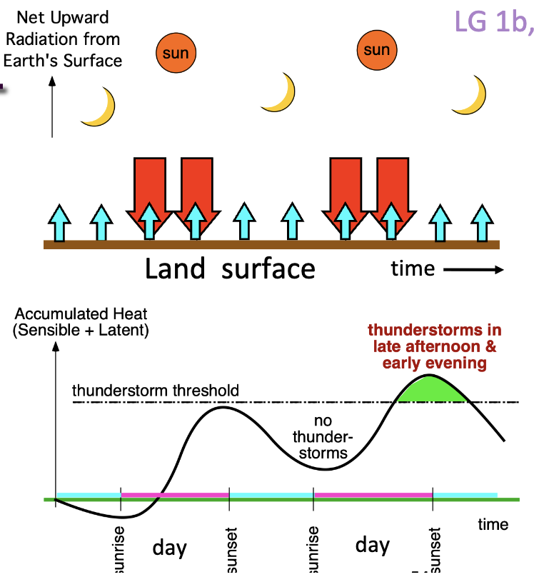
Dangerous times: late afternoon and early evening are most likely times because maximum solar heating accumulates near sunset
Dangerous places: small structures, nearby metallic objects, trees, water, open fields, hilltops
*Florida is a lightning alley in N. America, Africa has highest density of lightning worldwide;
Explain lightning risk: how it affects people; and what you can do to stay safe
how it affects people: 90% people survive a lightning strike, lightning strikes can cause cardiac arrest, severe burns, and skin patterns known as Lichtenberg figures
Safe places: fully enclosed metal vehicle with windows up (faraday cage directs currents to the ground), permanent building
when outdoors - crouch with feet together and hands over ears
30/30 rule - If the time between seeing lightning and hearing thunder is 30 seconds or less (meaning the storm is within ~10 km), move indoors immediately. Stay inside until 30 minutes after the last sound of thunder or flash of lightning.
estimate distance - Count the seconds between seeing the lightning flash and hearing the thunder, then divide by 3 to estimate the distance in km
Define Thunderstorms
Thunderstorms are thick clouds with lightning and thunder. Thunderstorms are made of large cells that lasts 15-45 minutes.
Cloud top is near the top of the troposphere at 10-15km, Cloud base is near the ground at ~1km altitude. It looks like an anvil/mushroom.

Thunderstorm Cell Life Cycle
1. The Cumulus stage is where there is an updraft, no rain, and no anvil.
2. The Mature stage has up and downdrafts, heavy rain and a distinct anvil
3. The Dissipating stage has a downdraft, light rain, and a fuzzy anvil
Multicell Thunderstorms
Multicell Thunderstorms are most thunderstorms, containing 2 or more cells, and typically last for longer than any individual cell
Differentiate Updraft and Downdraft
Updraft: rising warm, moist air
Downdraft: sinking cooled, dense air driven by precipitation
How Solar Energy is absorbed to power Storms
Solar energy is absorbed
1. Top (mesosphere) - absorns non visible light
2. Middle (stratopause) - absorbs uv by good ozone
3. Bottom (earth surface) - sunlight passes through the air to heat the ground which heats the lower atmosphere to power storms
→ warm ground heats air in troposphere (the bottom 11km) and powers storms

How the Surface Heat Budget powers Storms
Some solar energy reflects back into space from clouds and the ground, Some is absorbed by the ground and warms it.
The ground’s sensible heat warms the air, increasing air temperature. Latent heat from evaporated water from lakes is released, increasing air humidity.
→ the temperature and humidity fuels storms

How the Daily Cycle powers Storms
Input of energy from Solar heating during the day inputs heat energy
Loss of energy from Infrared radiation (IR) cooling day and night
The Greatest accumulation of heat is near sunset (late afternoon and early evening) everyday at the end of each charging cycle → most likely time of day for thunderstorm formation
list and describe the storm hazards and disaster scales covered in this course
use images and videos from weather radars (reflectivity & Doppler velocity) and satellites
(visible & infrared) to identify storm characteristics and anticipate storm changes.

Using Visible Satellite Images to observe Thunderstorms
Satellites observe the tops of clouds from above, showing the cloud top, the main anvil, and distinct structure. Visible imagery is in black and white and only works during the daytime by capturing sunlight.
Clues: oval shape of the anvil cloud, shadow under anvil cloud, updraft overshoot pinpointing the violent core updraft stem

Using Infrared (IR) Satellite Images to observe Thunderstorms
Satellites measure thermal radiation released by cloud tops to determine cloud top temperature, cold cloud tops correspond to high altitudes, and rapidly cooling tops indicate an intense rising updraft
Using a Weather Radar to observe Thunderstorms
Radars transmit microwave signals that reflect off precipitation inside the updraft and downdraft (stem) of the cloud