spatial exam 1 key
 Call Kai
 Learn
Learn Practice Test
 Spaced Repetition
 Match
Match Flashcards
 Knowt Play
1/28

There's no tags or description
Looks like no tags are added yet.
Name | Mastery | Learn | Test | Matching | Spaced | Call with Kai | Chat |
|---|
No analytics yet
Send a link to your students to track their progress
29 Terms
Name the two primary spatial data models used to represent geographic information in GIS.
raster and vector
What is the purpose of a projected coordinate system?
- To map the Earth's round surface onto a flat plane
- to minimize potential distortion in area, direction, distance, and/or angles
List the six essential map elements that should be included in your map layouts for this course
- map view
- north arrow
- scale bar/scale text
- neatlines
- legend
- metadata
Describe how the AND and OR operators determine which features are selected when submitting an attribute query
- When the combinatorial AND is used in a query, all criteria must be true.
- When the combinatorial OR is used in a query, only one criteria must be true
Provide an example management need where one would employ the UPDATE tool
- Landowner decides to establish a new lake on their property
- Surveyor GPS'd the lake boundary
- land manager can then use the UPDATE command to update the existing GIS data by replacing the 'old' landcover type(s) with the new lake boundary polygon
Convert the following geographic coordinates from Degrees, Minutes, and Seconds (DMS) format to Decimal Degrees (DD): 33° 56' 35.39" N, 83° 22' 14.39" W. Show your calculations and round your answers to the nearest ten-thousandth of a degree
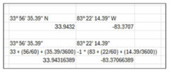
answer and question are on other side

List three inherent measurements of a polygon feature
Perimeter, area, XY coordinate of centroid
List two inherent measurements of a line/polyline feature
Length, XY coordinates of beginning and end of line
List one inherent measurement of a point feature
XY coordinate of point
Provide an example of a real-world phenomenon that is better represented using a continuous raster.
Elevation, slope, rainfall, etc
Regarding the geographic coordinate system WGS:
1. Where on Earth is the longitude origin located?
2. Where on Earth is the latitude origin located?
3. Where on Earth is the north-south origin located?
4. Where on Earth is the east-west origin located?
5. What is the range of latitude values?
6. What is the range of longitude values?
1. Greenwich England, Prime Meridian
2. Equator
3. equator
4. prime meridian
5. -90 to 90
6. -180 to 180
Regarding the UTM coordinate system:
1. What is its unit of measure?
2. what is the x-coordinate of the middle of UTM Zone 17?
3. what is the y-coordinate if I am 3,766,800 meters north of the Equator?
4. How many UTM zones are there?
5. As you move westward, what happens to the Y-coordinate (northing) value?
6. As you move westward, what happens to the X-coordinate (easting) value?
1. meters
2. 500,000
3. 3,766,800
4. 60
5. nothing
6. decreases
For each bullet, provide a short description the GIS data
layer(s) required if a land manager needs:
1. the Lat/Lon of each structure on the property...
2. the area in square meters of the main pond...
3. the amount of linear road frontage for a particular property...
4. the percentage of agriculture land within the riparian zone...
5. to understand how many bird nest locations are near the lake...
6. to generate an acreage summary presenting the area of each unique cover type in the forest
1. Point feature showing location of structures
2. polygon feature of the pond boundary
3. there is no three
4. polygon layer of agriculture land and polygon feature of riparian zone
5. point layer of the nest locations and a polygon feature with the lake
6. polygon cover type layer
the type of raster that stores measurements of height above sea level
continuous raster
when submitting a query using the OR combinatorial, a selection occurs if
at least one criterion is true
inconsistent scale is a characteristic of
longitude
intrinsic measurement of a point
x-coordinate
when submitting a query using the AND combinatorial, a selection occurs if
all criteria are true
the result if I submit an attribute query and 18 polygons are selected
18 records are selected in the attribute table 5
number of minutes in one degree
60
type of raster whose pixel values do not have a meaningful interpretation
image raster
the trail connecting your deer stand and the cabin
polyline
number of UTM zones
60
type of raster whose pixel values reflect discrete classes
thematic raster
as one moves east of the UTM zone's central meridian
x-values increase
what would you use to know what areas from Input Layer 2 occur within XX distance of features in Input Layer 1?

what would you use to know what areas from Input Layer 2 occur further than XX distance of features in Input Layer 1?

what would you use to identify overlapping areas within XX distance of specific features (SELECTed) from Vector Data 1 and YY distance of features in Vector Data 2?
