Geomorphology Midterm UGA October 8th
 Call Kai
 Learn
Learn Practice Test
 Spaced Repetition
 Match
Match Flashcards
 Knowt Play
1/132

There's no tags or description
Looks like no tags are added yet.
Name | Mastery | Learn | Test | Matching | Spaced | Call with Kai | Chat |
|---|
No analytics yet
Send a link to your students to track their progress
133 Terms
Glacial Interglacial Cycles
Periods during during the Quaternary period where the Earth would enter glacial periods and interglacial periods. Glacial periods had glaciers going oftern to illinois and wisconsin, currently in an interglacial.
Quaternary Period
the latest 2.6 million years, very important period for landscape development
radiocarbon
dating method used carbon 14
cosmogenic nuclides
dating method showing how long a surface has been exposed for
Luminescence
dating method based on how long quartz/feldspar has NOT been exposed to light (how long has this sand been buried and stable)
dendrochronology
based on rings of tree (VERY FUCKING ACCURATE AND AWESOME)
Potassium Argon Dating
dating lava flows and tephra (similar to radiocarbon cause of the radio part)
Weathering rinds
ring of weathered rock around rock that indicate exposure
cesium 137
only started existing when they dropped the first atomic bomb, shows if something was formed before or after 1963
18 oxygen
proxy for global average temperature, but represents global ice volume
2 parts of the quarternary
pleistocene and holocene (last 11,700 years of 2.6 million years)
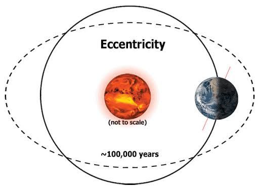
eccentricity, obliquity, precission
3 extraterrestrial drivers of climate change
eccentricity
obliquity

precision

lake bog marine sediments, ice cores, stalagmites
continous long term records of a changing climate
loess
periglacial or windborne sediment (deposits can show record of glaciers)
true
true or false:
Many parts of the world are forecast to have increased landslides, largely because warmer air
silicates
silicon + oxygen
Carbonates
calcite, dolomite, agricultural lime and concrete
Sulfates
gypsum, drywall
sulfides
pyrite and metals
halides
SALT
Oxides
hematite
magnetite
rutile
metals adn paint
Intrusive Igneous
cooled below surface cooled slowly, coarse
Extrusive igneous rock
Cooled above the surface
cooled quickly ; fine grained
FELSIC
rich in FELDSPAR and SILICA
MAFIC
rich in MAGNESIUM and IRON
Batholith
MASSIVE intrusive body (stone mountain)
Stock
smaller intrusive body
sill
intrusive LAYER concordant with strata
Dike
intrusive layer that CUTS THROUGH strata
Laccolith
intrusive layer that pushes overlying strata to form a dome (think big pimple
columbia plateau
basalt lava plateau (pacific northwest)
Lithification
process of sediments turning into rocks
clastic sedimentary
rock made from particles of other rocks
nonclastic sedimentary
formed from evaporation of chemical solution or from organic deposition (coal
conglomerate
poorly sorted clastic rock
shale
fine grained muds and clays
stratification
layering of sedimentary rock
landforms of flat lying sedimentary rocks
plateus mesas buttes pinnacles
contact metamorphism
rock changed by ONLY heat
foliated
layered
quartzite og form
sandstone
gneiss og form
granite
radon
gas sneaking into your house to kill you
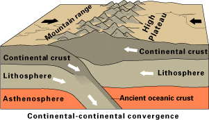
continental crust
the crust that is thick and felsic
oceanic crust
thin crust that is mafic
lithosphere
rigid and made of crust and uppermost mantle
asthenosphere
plastic and flows readily
orogeny
wegener
guy who made pangea, wasnt believed until the 1960s
earthquakes volcanoes and mountain ridges MOSTLY happen on plate boundaries
where does volcanoes and earthquakes mostly happpen?
Isostasy
equilibrium between floating landmasses and denser rock beneath them, think iceburg. thicker the crust, deeper its roots and higher it stands.
isostatic readjustment
erosion of mountain will make crust thinner and then mountain readjust upward
glacio-static rebound
icebergs on canada melted, but the lands adjusting upwards anyhow
fault scarp
exposed cliff-lake face
sand blows
how to know about evidence about those weird ass new madrid and charleston earthquakes
lahars
viscous mudflows of pyroclastic debris and water
pahoehoe
smooth and ropy lava
aa
blocky and pocky lava
maars
craters (no volcano) from violent eruptions under the surface into groundwater so it explodes
caldera
collapsed magma chamber
trap
word used for the big ass flood plains
columner basalt
when basalt CRACKS into this
landscape inversion
when lava flows into a valley and the surrounding rock erodes leaving the lava around.
Batholith
what is the sierra nevada mountain range
jointing
fractures in bedrock without apparent movement
exfoliation
outer layes peel away releasing confining pressure
inselberg
prominent steep-sided hills of resistant rock rising abruptly
Bornhardt
dome shaped steep sided hills
tors and nubbins
medium scale residual hills
corestones and boulders
smallest type of landform from exhumed intrusive igneous rocks
stone mountain
inselberg in Georgia
talus
the shit that falls at the bottom of a rock cause it missed its fucking mouth
strike
compass direction og rock layer
dip
angle of tilted bed
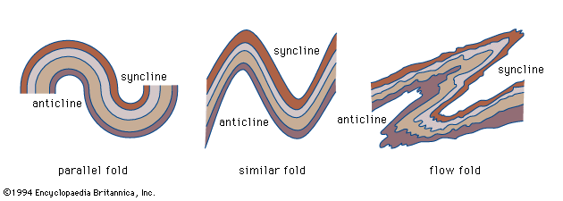
anticlines
ARCH

syclines
TROUGH

plunging anticline
surface rocks are younger at nose
plunging syncline
surface rocks are older at nose
hogback
greater than 30 degree ridge (the flatirons)
cuesta
asymmetric ridge with gentle dip slope and STEEP cliff
homoclinal ridge
10 degrees to 30 degrees
dome
ridges with cliffs facing center, oldest strata in the middle, youngest in the outside
basin
ridges with cliffs facing outwards, middle is youngest strata, oldest strata on the outside
fault
displacement of rock on one side of fracture with respce to rock on other side
joint
fracture in earth’s crust, but no displacement of rock bodies
hanging wall
block of rocks above fault line
footwall
block of rocks below the fault line
compressional reverse fault
hanging wall moves up, fault plane angle MORE than 45 degrees
compressional thrust fault
hanging wall moves, but the angle is LESS than 45 degrees
tensional normal fault
hanging wall moves down relative to footwall
nevada
place where there is a basin and range ( horsts and valleys)
horst
upfaulted block
graben
downfaulted block
rift valleys
long narrow band of downdropped blocks caused by plated being pulled apart (IE east africa valley system)
east african rift valley
strike slip fault
blocks of crustal rock move laterally