APHUG Final Exam
0.0(0)Studied by 3 people
Build your Mastery score
 Multiple Choice & FRQ
 Call Kai
Card Sorting
1/394

Earn XP
Description and Tags
All key terms from tbook and models + maps
395 Terms
1
New cards
abiotic
Composed of nonliving or inorganic matter
2
New cards
Acculturation
The process of changes in culture that result from the meeting of two groups, each of which retains distinct culture features.
3
New cards
Assimilation
The process by which a group's cultural features are altered to resemble those of another more dominant group.
4
New cards
atmosphere
A thin layer of gases surrounding Earth
5
New cards
behavioral geography
the study of the psychological basis for individual human actions in space
6
New cards
Biosphere
All living organisms on Earth, including plants and animals, as well as microorganisms
7
New cards
Biotic
composed of living organisms
8
New cards
Cartography
The science of making maps
9
New cards
Citizen Science
scientific research by amateur scientists
10
New cards
climate
The long-term average weather condition at a particular location
11
New cards
Concentration
the spread of something over a given area
12
New cards
connection
Relationships among people and objects across the barrier of space.
13
New cards
conservation
The sustainable management of a natural resource
14
New cards
Contagious Diffusion
The rapid, widespread diffusion of a feature or trend throughout a population.
15
New cards
Cultural ecology
Geographic approach that emphasizes human-environment relationships.
16
New cards
Cultural landscape
An approach to geography that emphasizes the relationships among social and physical phenomena in a particular study area.
17
New cards
Culture
The body of customary beliefs, social forms, and material traits that together constitute a group's distinct tradition.
18
New cards
Density
The frequency with which something exists within a given unit of area
19
New cards
diffusion
The process of spread of a feature or trend from one place to another over time
20
New cards
distance decay
the diminished importance and eventual disappearance of a phenomenon with increasing distance from its origin
21
New cards
distribution
The arrangement of something across Earth's surface.
22
New cards
ecology
The scientific study of ecosystems
23
New cards
ecosystem
a group of living organisms and the abiotic spheres with which they interact
24
New cards
environmental determinism
A nineteenth- and early twentieth-century approach to the study of geography that argued that the general laws sought by human geographers could be found in the physical sciences. Geography was therefore the study of how the physical environment caused human activities.
25
New cards
expansion diffusion
The spread of a feature or trend among people from one area to another in a snowballing process.
26
New cards
Formal Region (Uniform Region)
An area in which everyone shares in common one or more distinctive characteristics
27
New cards
Functional Region (Nodal Region)
an area organized around a node or focal points ex: the reception of a TV station.
28
New cards
Geographic Information Science (GIScience)
The development and analysis of data about Earth acquired through satellite and other electronic information technologies
29
New cards
Geographic Information System (GIS)
A computer system that stores, organizes, analyzes, and displays geographic data.
30
New cards
Geotagging
identification and storage of a piece of information by its precise latitude and longitude coordinates
31
New cards
Global Positioning System (GPS)
A system that determines the precise position of something on Earth through a series of satellites, tracking stations, and receivers.
32
New cards
Globalization
Actions or processes that involve the entire world and result in making something worldwide in scope.
33
New cards
Greenwich Mean Time (GMT)
the time in the zone encompassing the prime meridian, or 0 degrees longitude
34
New cards
Hearth
The region from which innovative ideas originate
35
New cards
Hierarchical Diffusion
the spread of a feature or trend from one key person or node of authority or power to other persons or places
36
New cards
Humanistic Geography
The study of different ways that individuals form ideas about place and give those places symbolic meanings.
37
New cards
hydrosphere
All of the water on and near Earth's surface
38
New cards
International Date Line
An arc that for the most part follows 180° longitude, although it deviates in several places to avoid dividing land areas. When you cross the International Date Line heading east (toward America), the clock moves back 24 hours, or one entire day. When you go west (toward Asia), the calendar moves ahead one day.
39
New cards
Latitude
The numbering system used to indicate the location of parallels drawn on a globe and measuring distance north and south of the equator.
40
New cards
Lithosphere
Earth's crust and a portion of upper mantle directly below the crust
41
New cards
location
The position of anything on Earth's surface.
42
New cards
Longitude
the numbering system used to indicate the location of meridians drawn on a globe and measuring distance east and west of the prime meridian
43
New cards
map
A two-dimensional, or flat, representation of Earth's surface or a portion of it.
44
New cards
map scale
The relationship between the size of an object on a map and the size of the actual feature on Earth's surface.
45
New cards
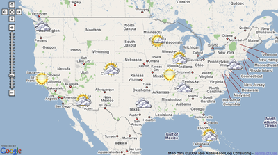
mashup
a map that overlays data from one source on top of a map provided by a mapping service
46
New cards
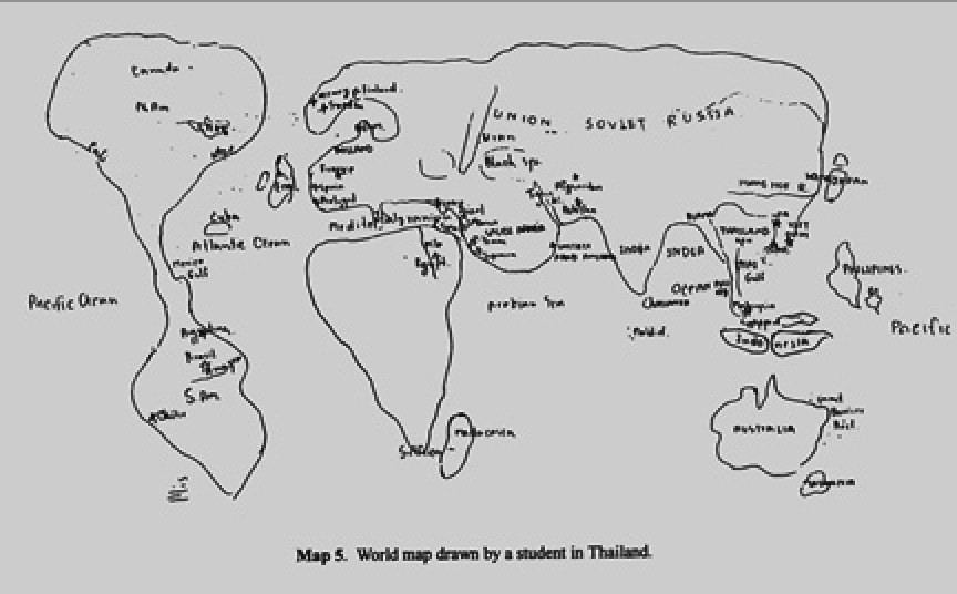
mental map
A representation of a portion of Earth's surface based on what an individual knows about a place, containing personal impressions of what is in a place and where places are located.
47
New cards
meridian
An arc drawn on a map between the North and South poles.
48
New cards
network
A chain of communication that connects places
49
New cards
nonrenewable resource
Something produced in nature more slowly than it is consumed by humans
50
New cards
parallel
A circle drawn around the globe parallel to the equator and at right angles to the meridians.
51
New cards
Participatory GIS (PGIS)
Community-based mapping, representing local knowledge and information.
52
New cards
Pattern
The geometric or regular arrangement of something in a study area.
53
New cards
Place
A specific point on Earth distinguished by a particular character.
54
New cards
Polder
Land created by the Dutch by draining water from an area.
55
New cards
Possibilism
The theory that the physical environment may set limits on human actions, but people have the ability to adjust to the physical environment and choose a course of action from many alternatives.
56
New cards
Poststructuralist Geography
The study of space as the product of ideologies or value systems of ruling elites.
57
New cards
Preservation
Maintenance of a resource in its present condition, with as little human impact as possible.
58
New cards
Prime Meridian
The meridian, designated at 0° longitude, which passes through the Royal Observatory at Greenwich, England.
59
New cards
Projection
The system used to transfer locations from Earth's surface to a flat map.
60
New cards
Region
An area distinguished by a unique combination of trends or features.
61
New cards
Relocation diffusion
The spread of a feature or trend through bodily movement of people from one place to another.
62
New cards
Remote Sensing
The acquisition of data about Earth's surface from a satellite orbiting the planet or other long-distance methods.
63
New cards
renewable resource
Something produced in nature more rapidly than it is consumed by humans
64
New cards
resource
A substance in the environment that is useful to people, is economically and technologically feasible to access, and is socially acceptable to use.
65
New cards
scale
Generally, the relationship between the portion of Earth being studied and Earth as a whole, specifically the relationship between the size of an object on a map and the size of the actual feature on Earth's surface.
66
New cards
site
The physical character of a place
67
New cards
situation
the location of a place relative to other places
68
New cards
space
The physical gap or interval between two objects
69
New cards
space-time compression
The reduction in the time it takes to diffuse something to a distant place, as a result of improved communications and transportation systems
70
New cards
Spatial Association
The relationship between the distribution of one feature and the distribution of another feature.
71
New cards
stimulus diffusion
The spread of an underlying principle, even though a specific characteristic is rejected.
72
New cards
sustainability
The use of Earth's renewable and nonrenewable natural resources in ways that do not constrain resource use in the future.
73
New cards
syncretism
A blending of two or more religious traditions
74
New cards
toponym
The name given to a portion of Earth's surface.
75
New cards
transnational corporation
A company that conducts research, operates factories, and sells products in many countries, not just where its headquarters or shareholders are located.
76
New cards
uneven development
The increasing gap in economic conditions between core and peripheral regions as a result of the globalization of the economy.
77
New cards
vernacular region (perceptual)
an area that people believe exists as part of their cultural identity
78
New cards
Volunteered Geographic Information (VGI)
Creation and dissemination of geographic data contributed voluntarily and for free by individuals
79
New cards
Agricultural Density
The ratio of the number of farmers to the amount of arable land
80
New cards
Arithmetic Density
The total number of people divided by the total land area.
81
New cards
census
A complete enumeration of a population.
82
New cards
Crude Birth Rate (CBR)
the number of live births per 1,000 individuals per year
83
New cards
crude death rate (CDR)
the number of deaths per 1,000 individuals per year
84
New cards
demographic transition
The process of change in a society's population from a condition of high crude birth and death rates and low rate of natural increase to a condition of low crude birth and death rates, low rate of natural increase, and a higher total population.
85
New cards
demography
Scientific study of human populations.
86
New cards
dependency ratio
the number of people who can't work
87
New cards
doubling time
The number of years needed to double a population (insert equation here)
88
New cards
ecumene
The proportion of the earth inhabited by humans.
89
New cards
elderly support ratio
The number of working-age people (ages 15 to 64) divided by the number of persons 65 and older.
90
New cards
epidemiologic transition
The process of change in the distinctive causes of death in each stage of the demographic transition
91
New cards
epidemiology
Branch of medical science concerned with the incidence, distribution, and control of diseases that affect large numbers of people.
92
New cards
industrial revolution
A series of improvements in industrial technology that transformed the process of manufacturing goods.
93
New cards
Infant Mortality Rate (IMR)
The total number of deaths in a year among infants under 1 year old per 1,000 live births.
94
New cards
life expectancy
A figure indicating how long, on average, a person may be expected to live
95
New cards
maternal mortality rate
Number of deaths per thousand of women giving birth.
96
New cards
medical revolution
Medical technology invented in Europe and North America that is diffused to the poorer countries of Latin America, Asia, and Africa. Improved medical practices have eliminated many of the traditional causes of death in poorer countries and enabled more people to live longer and healthier lives.
97
New cards
natural increase rate (NIR)
The percentage by which a population grows in a year
98
New cards
overpopulation
The number of people in an area exceeds the capacity of the environment to support life at a decent standard of living.
99
New cards
pandemic
Disease that occurs over a wide geographic area and affects a very high proportion of the population.
100
New cards
physiological density
The number of people per unit of arable land