🌪️🌩️⛈️EXAM 2 REVIEW THE ELECTRIC BOOGALOO RAHHHH
 Call Kai
 Learn
Learn Practice Test
 Spaced Repetition
 Match
Match Flashcards
 Knowt Play
1/242

There's no tags or description
Looks like no tags are added yet.
Name | Mastery | Learn | Test | Matching | Spaced | Call with Kai | Chat |
|---|
No analytics yet
Send a link to your students to track their progress
243 Terms
Thunderstorms: unstable, conditionally unstable, warm, moist
(Thunderstorms:) form in a(n) [term] environment, usually a (term term) environment in (term, term) conditions.
In unstable environments, low-level warmth and moisture is often capped by a stable layer that needs to be overcome. To trigger convection, one must lift a parcel past the “cap” with surface heating, terrain, cold fronts, sea-breeze fronts, dryline, and more!
(In unstable environments, low level warmth and moisture is often TERMED by a TERM layer that needs to be overcome. To TERM TERM, one must TERM a parcel past the “cap” with)
(TERM TERM
TERM
TERM fronts
TERM-TERM fronts
TERM
and more!)
thunderstorms
convective storms that contain lightning and thunder
LCL stands for lifting condensation level — the level where an air parcel cools to its dew point and condenses, producing clouds. Thus, the LCL is also the cloud base, and the point where the saturation mixing ratio and the actual mixing ratio are equal. It can be found at the intersection of the DALR and moisture content lines, and after reaching it, follow the MALR because the parcel is saturated.
(LCL stands for (term term term) — the level where an air parcel cools to its term term and terms, producing terms. Thus, the LCL is also the cloud term, and the point where the term term ratio and the term term ratio are equal. It can be found at the intersection of the TTTT and term constant lines, and after reaching it, follow the TTTT because the parcel is saturated).
LFC stands for level of free convection — the boundary between stable and unstable layers of air. This is where parcels switch from negative to positive buoyancy as their temperatures exceed the environment. How fast it accelerates upward is directly proportional to the difference between it and the environment.
(LFC stands for (term of term term) — the boundary between term and term layers of air. This is where parcels switch from term to term buoyancy as their temperatures term the environment. How term it accelerates upward is term proportional to the term difference between it and the term)
equilibrium level, level of neutral buoyancy, located in the stratosphere
EL stands for (term term). It can also be called (term of term term). It is (located in the term).
convective inhibition
CIN stands for (term term) — a layer that prevents convection, or that prevents warm air from rising
Convective available potential energy
(CAPE stands for (term term term term). It is the term associated with term from the term difference between the air parcel and its term environment. Because it is energy, it has units of (units). This energy may be (termed) into (term) energy in storms given the right conditions)
LIFT, CAPE, CIN,
there are (three key ways to calculate the expected severity of a thunderstorm:)
(TERM), (TERM), and (TERM).
Lift is the lifting index, the difference between a surface air parcel’s temperature if lifted to 500mb and the environmental temperature at 500mb. Negative values indicate a parcel that is warmer than the environment
[LIFT is the (terming term), the (term term) between a (term air parcel’s term) if lifted to (###unit) and the environmental temperature at (###unit). (Term values indicate a parcel that is TERMER than the environment).
CAPE is the convective available potential energy. It is the summation of temperature differences between lifted parcel and environment during its “free convection.”
(CAPE is the term term term term. It is the term of term terms between a lifted parcel and its environment during free convection).
CIN is convective inhibition. It is the summation of temperature differences between a lifted parcel and the environment through the capping (stable) layer.
(CIN is (term term). It is the summation of term terms between a lifted parcel and its environment through the term/ term layer)
By comparing the lifted parcel temperature with the environmental temperature, we can assess if there will be convection and how severe it will be.
By (terming) the (term term temperature) to the (term temperature), we can assess (if there will be convection) and (how severe) it will be.
Stability varies over the day — in other words, there’s a large diurnal variation— because of insolation and surface heating. As the earth warms, more CAPE — a measure of instability — is introduced, growing the potential convection layer. Even with more generally unstable conditions, in the morning, there may be an inversion, capping vertical growth. As the sun warms the earth and earth releases heat, warming the near-surface air, the inversion dissipates. And as temperatures rise, CAPE grows. Thus, a small cumulus humilis in the morning can grow into a towering cumulonimbus in the afternoon because atmospheric instability varies with surface heating and the diurnal cycle.
(Stability varies over the term — in other words, there’s a term term variation — because of term and surface heating. As the earth (terms), more TTTT — a measure of instability— is introduced, terming the potential convection layer.
Even with more generally term conditions, in the morning, there may be an (term), capping vertical growth. As the sun (terms) the earth and earth (terms) heat, warming the near-surface air, the inversion (terms). And as temperatures rise, CAPE grows. Thus, a small cumulus humilis in the morning can grow into a towering cumulonimbus in the afternoon because atmospheric term varies with surface term and the term cycle.)
Thunderstorms transport warm, moist air aloft and transport cool air back to the surface. In other words, they stabilize a destabilized atmosphere.
(Thunderstorms transport TERM, TERM air aloft and transport TERM air back to the surface. In other words, they TERM a destabilized atmosphere).
air-mass (ordinary cell) thunderstorms, warm humid air masses away from fronts, last for less than an hour. Other kinds: multicell thunderstorms, supercell thunderstorms
(Term-term / term term thunderstorms) form in (term, term air masses away from terms). They (last for less than an term). There are also (other kinds:) of thunderstorms, including (termterm thunderstorms), (termterm thunderstorms).
severe thunderstorms need to have one or more of these: tornado, hail greater than or equal to 1in, surface wind gusts over 50kts / 58mph to be classified as severe.
(Severe thunderstorms need to have one or more of these:
TERMS
TERM term term or term term to #unit
TERM wind gusts over ##kts / ##mph
to be classified as severe)
wind shear
change of wind with height
Air mass thunderstorms form with little/no wind shear. They can form with just surface heating, does not need large scale forcing like cold fronts. Life cycle lasts 45-60 minutes, and there are 3 stages: cumulus, mature, and dissipating.
[[Air mass thunderstorms form with term/term wind term. They can form with just term term, does not need large scale term like term fronts. Life cycle lasts ###-###units, and there are ### stages: (term), (term) and term)]].
entrainment
mixing of environmental air into the cloud
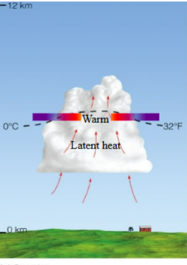
The first stage of the formation of an air mass thunderstorm is the cumulus stage. The cloud is an actively growing cumulus dominated by an updraft that transports warm, moist air upward. No precipitation reaches the surface, but cloud droplets are growing large and have started the processes that create precipitation: condensation, collision/coalescence, and accretion if cold. Air parcel temperatures within the cloud are warmer than the surrounding air, and latent heating adds a lot of additional heat
(The first stage of the formation of an air mass thunderstorm is the TERM stage. The cloud is an TERM TERM cumulus dominated by an TERM that transports warm, moist air TERM. no precipitation reaches the TERM, but cloud droplets are growing large and have started the processes that create precipitation: term, term/term, and term if cold. Air parcel temperatures within the cloud are Termer than the surrounding air, and term terming adds a lot of additional heat.)
During the mature stage of an air-mass thunderstorm, the storm is most intense, cloud tops can reach the tropopause. They are characterized by warm updraft from the surface, a cool downdraft generated by cooling from entrainment that evaporates cloud droplets and rain. Precipitation adds to downward motion due to drag. The downdraft can produce strong, gusty winds at the surface
During the TERM stage of an air-mass thunderstorm,
storm most term, cloud tops can reach the term
Characterized by
term updraft from the surface
term downdraft generated by terming from term that evaporates cloud droplets and rain
precipitation adds to the term due to drag
The term can produce strong, gusty winds at the surface
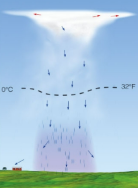
During the dissipating stage of an air-mass thunderstorm
the storm is dominated by downdraft
precipitation weakens
the storm has stabilized the environment
rearranged cold air below and cold air aloft
During the TERM stage of an air-mass thunderstorm
the storm is dominated by term
Precipitation terms
end up with a term pool of air at the ground, with term air now aloft
The storm has termed the environment
rearranged term air below and term air aloft
In a single-cell thunderstorm, there is a little wind shear. The lack of wind shear is why the single-cell thunderstorm is so short-lived, because rain falls straight down and cuts off the updraft. (Recall that the updraft is the warm, rising air that creates thunderstorms, and that rain cools the updraft, disrupting convection)
in a single-cell thunderstorm, there is A LOT/ A LITTLE of wind shear. The TERM of wind shear is why the single-cell thunderstorm is so TERM-lived, because rain falls straight down and TERMS TERM the updraft (recall that the updraft is the warm, rising air that creates thunderstorms, and that rain cools the updraft, disrupting convection.
Severe thunderstorms form in environments with large instability and large amount of vertical wind shear.
Severe thunderstorms form in environments with (TERM TERM) and (TERM amount of TERM wind TERM). Types
Convection, or warm air rising in updrafts, is the engine on thunderstorms. Latent heating through condensation is associated with convection. Subsidence, or cold air sinking, is the “exhaust” of thunderstorms and also the “brake”. Latent cooling through evaporation is associated with thunderstorm outflow and dissipation. Mixing through entrainment can also put a brake on thunderstorms if more cooler environmental air is mixed in than the amount of warm air rising
[[Convection, or warm air rising in (terms), is the “engine” on thunderstorms. (Term heating) through (term) is associated with convection.
[[Subsidence, or cold air sinking, is the “exhaust” of thunderstorms and also the "brake.” (term cooling) through (Term) is associated with thunderstorm term and dissipation. Mixing through (term) can also put a “brake” on thunderstorms if more cooler environmental air is mixed in than the amount of warm air rising)
cumulus stage
what stage of the air-mass / single-cell thunderstorm is this?
Mature stage
what stage of the air-mass / single-cell thunderstorm is this?

dissipating stage
what stage of the air-mass / single-cell thunderstorm is this?
Severe thunderstorms form in an environment with large instability and large vertical wind shears
(Severe thunderstorms form in an environment with large term and large term term term).
Types of severe thunderstorms: MESS BED
Mesoscale convective complexes, supercells, squall lines, bow echoes, derechos
[[ types of severe thunderstorms: MESS BED
Me — (Term term terms)
S — (terms)
S — (term terms)
B.E — (Term terms)
D — (Term) ]]
Three key ingredients for severe weather: WUT
Wind shear
Unstable
Triggering mechanism
(Three key ingredients for severe weather: WUT
W— TERM TERM
U— TERM
T — TERM TERM)
An important part of multicell thunderstorms is vertical wind shear. When the updraft is caught by the wind and tilted, the updraft becomes separate from the downdraft, preventing the downdraft from killing the updraft and therefore the storm. Because they are separate from the updraft, downdrafts can be quite strong and create a cold pool and gust front that sustains the storm
(An important part of TERM thunderstorms is vertical wind shear. When the updraft is caught by the wind and termed, the updraft becomes term from the downdraft, preventing the downdraft from terming the updraft and therefore the storm. Because they are separate from the updraft, terms can be quite strong and create a term pool and gust term that sustains the storm)
mesohigh
An area of high pressure at the surface created by the cold, dense pool of air from the downdraft
gust front
leading edge of cold air associated with the downdraft. lots of turbulence makes wind gusty, which drops temperature and increases pressure. precipitation usually follows.
Cold fronts force warm upward, triggering convection and instability. In multicell thunderstorms, tilted updrafts prevent the downdraft from cutting off the updraft, sustaining the thunderstorm. Instead, the downdraft creates its own front, called the gust front, which pushes warm air ahead of the thunderstorm upward and continuously generates new storm cells
(Cold fronts force warm air term, triggering term and instability. In term thunderstorms, tilted updrafts prevent the downdraft from cutting off the term, sustaining the thunderstorm. Instead, the downdraft creates its own term, called the term term, which pushes warm air ahead of the thunderstorm upward and continuously generates new storm cells).
shelf cloud
Also called an arcus cloud, this forms when a relatively stable of air is lifted over a denser/cold air gust front ahead of a multicell thunderstorm. These are harmless on their own, but signal that a large, powerful thunderstorm is coming!
Roll clouds
these clouds form behind the gust front from wavy atmospheric patterns at the top of the boundary layer
outflow boundaries
gust fronts are also called what?
Outflow boundaries, also known as gust fronts, can merge into a single front that can go much farther from the original storm and create new thunderstorms by lifting warm air over them
(Outflow boundaries, also known as term terms, can merge into a single front that can go much farther from the original storm and create new thunderstorms by lifting warm air over them).
Strong downdrafts are called downbursts. if the diameter of the downburst is less than or equal to 4km, it is called a microburst. If the diameter of the downburst is greater than 4km, it is called a macroburst. Downbursts can produce strong winds comparable to weak tornadoes at up to 146kts.
[[Strong downdrafts are called (terms). If diameter of the downburst is less than or equal to 4km, it is called a (term). If the diameter of the downburst is greater than 4km, it is called a (term). Downbursts can produce strong winds comparable to weak (terms) at up to ####unit.]]
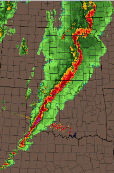
squall lines
multicell thunderstorms organized in a long line in front of a cold front, sometimes hundreds of kilometers ahead of it. In these systems, gravity waves and surface convergence promote lifting and convection.
bow echoes
small-ish (20-120km long) bow-shaped systems of convective multicell thunderstorms known for long swaths of damaging winds. Can be part of a squall line
derechos
very powerful bow echoes/ bow echoes on steroids that create strong straight-line winds over a large area
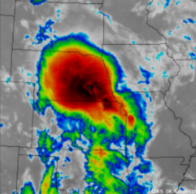
mesoscale convective complexes
Very, very large multicell thunderstorms with cold cloud shields and cold cores that can last for 6-12 hr. associated with heavy rain but can also produce tornadoes, severe winds, hail
supercells
these are powerful, long-lived (12hr) single-celled thunderstorms with a rotating updraft called a mesocyclone. Most tornadoes come from these; damaging hail and winds are also produced.
Hook Echo, Doppler Velocity
(Term term) indicates rotation in a supercell on a reflectivity radar, (term term) indicates how strong the rotation is, called gate-to-gate shear
mesocyclone
a rotating updraft. forms through low-level wind shear (rapid increase in wind speeds and rapid changes in direction) create a rotating tube that can go into the updraft.
the precipitation closest to the mesocyclone is hail, while the precipitation farther from the mesocyclone is rain, this is because precipitation must be more massive, like hail, to overcome the updraft and fall down
(the precipitation closest to the mesocyclone is term, while the precipitation farther from the mesocyclone is term. this is because a mesocyclone is a very strong updraft, and precipitation must be more massive, like hail, to overcome the updraft and fall down)
wall clouds are rotating near-surface clouds that form as the cloud base lowers; they are a near-surface manifestation of the mesocyclone. This is where tornadoes form.
[[ (Term terms) are rotating near-surface clouds that form as the cloud base lowers; they are a near-surface manifestation of the (Term). This is where (Terms) form.]]
tornado
A rapidly rotating column of air that blows around a small area of intense low pressure with a circulation that reaches the ground, made visible with a funnel cloud. They usually last for a few minutes and have a path length of 4mi, with a diameter of 100-600m
cyclostrophic balance means that tornadoes can spin in either direction, but they usually spin cyclonically, or counterclockwise
(Term term means that tornadoes can spin in either direction around a low-pressure core, but they usually spin cyclonically, or counterclockwise).
Tornadoes are NOT from a ‘clash of air masses’)
(Tornadoes are TERM from a ‘clash of air masses’)
cyclonic
when the winds spin counterclockwise, rotation is (term)
anticylonic
when the winds spin clockwise, rotation is (term).
mesocyclone formation: vertical wind shear creates a vortex tube that can be brought upwards by the updraft and changes the orientation of rotation. in other words, decreasing the area of rotation increases the speed of rotation
(Mesocyclone formation:
term wind term creates a term tube that can be brought upwards by the term and changes the orientation of term. The rotation of the mesocyclone decreases the term, increases the term, and increases the term. Air is brought in from the surroundings, increasing the spin through term of term term, which is visualized by a figure skater that brings arms in to spin fast. In other words, decreasing the term of rotation increases the term of rotation).
the rear flank downdraft can come around to the center of the mesocyclone and inhibit updraft at the surface under the stronger updraft aloft, leading to vertical stretching and rapid rotation through conservation of angular momentum
(term term term can come around to the term of the mesocyclone and term the updraft at the surface under the stronger updraft aloft, leading to term stretching and rapid term through conservation of angular momentum)
storm splitting
when a storm with two cores— one rotating anticyclonically and one rotating cyclonically — splits into two storms with two different cores
anticyclonically, clockwise
left mover after a storm split moves in what way?
cyclonically, counterclockwise
right mover after a storm split moves in what way?
the rotating cores of right movers and left movers in a storm split spin at the same speed
(the rotating cores of right movers and left movers in a storm split spin at the term speed).
cyclostrophic balance
force balance between pressure and centrifugal force around a low pressure core is called what?
Different rotations/circulations exist within the storm system, creating variations in the tornado structure. Multivortex tornadoes have secondary circulations, which are usually associated with wide tornadoes.
(Different rotations/terms exist within the storm system, creating terms in the tornado structure. Multivortex tornadoes have term circulations, which are usually associated with wide tornadoes)
Enhanced Fujita Scale, abbreviated as EF scale, is used to calculate tornado intensity. It is calculated by the damage to structures after the storm, not measured directly from within the storm
(Term Term Term, abbreviated as TT Term, is used to calculate tornado intensity. It is calculated by the term to structures after the storm, not measured directly from within the storm)
On average, the summer jet stream has a trough over the mountain west and a ridge over the northeast US. upward vertical motion is favored downwind of the trough. The cold front sweeps down to the southeast and creates thunderstorms. Florida has a lot of thunderstorms mainly because of the convergence at the head of the sea breeze.
On average, the summer jet stream has a term over the mountain west and a term over the northeast US. term vertical motion is favored downwind of the trough. The cold front sweeps down to the term and creates term. Florida has a lot of thunderstorms mainly because of the convergence at the head of the term term.
Tornadoes happen most in spring because of lingering cool, dry air above from the winter and moist warm air below from a renewed surplus of surface insolation
(Tornadoes happen most in term because of lingering term, term air above from the winter and term term air below from a renewed surplus of surface insolation)
A tornado watch is announced when conditions for tornadoes are present and the likelihood of tornadoes increases, a tornado warning is issued when a tornado has been spotted by a trained spotter or on radar. Radar cannot see the tornado itself since the scale of the tornadic circulation is small. The radar can, however, see the mesocyclone, which indicates tornadic activity.
(A tornado watch is announced when TERMS for tornadoes are present and the TERM of tornadoes increases.
A tornado warning is issued when a tornado has been spotted by a termed term or term term.
Radar cannot see the TERM TERM since the scale of tornadic circulation is very small. The radar can, however, see the TERM, which indicates tornadic activity.)
straightline wind damage— trees are flattened down in a diverging pattern, tornado damage—trees are down in different directions in a cyclonic pattern
(Straightline wind damage— trees are flattened down in a term pattern
Tornado damage— dress are down in term terms in a term pattern)
A —overshooting top
B—anvil
C—cumulonimbus
D—rain and/or hail
E—wall cloud
F—tornado
G—flanking line
Label the diagram:
A —term term
B—term
C—term
D—term and/or term
E—term term
F—term
G—term term

A—overshooting top, B—new cell, C—shelf cloud, D—stable air, E—warm moist air, F—gust front, G—downdraft rain area, H—wind, I — tropopause
What kind of thunderstorm is this a diagram of?
(Term thunderstorm).
Label the diagram
A—(Term term)
B—(term term)
C—(term term)
D—(term term)
E—(term term term)
F—(term term)
G—(term term term)
H—(term)
I—(term)

multicell squall line thunderstorm known for its linear shape, impressive length yet narrow width, and heavy rain and wind
This is a (MULTICELL/SINGLECELL TERM TERM Thunderstorm known for its linear shape, impressive length yet narrow width, and heavy rain and wind.)
Multicell bow echo thunderstorm
This is a (MULTICELL/SINGLECELL TERM TERM Thunderstorm known for its termlike shape and damaging term-line winds).

multicell mesoscale convective complex thunderstorm, known for its large size and circular shape
This is a (multicell/singlecell term term term thunderstorm, known for its term size and term shape).
singlecell thunderstorm called a supercell, known for tilted updrafts, hail, and notably rotation and tornadoes
This is a (multicell/singlecell thunderstorm called a term, known for tilted updrafts, hail, and notably rotation and terms).

straight-line wind event
Was this damage caused by a tornado or a straight-line wind event?

tornado
Was this damage caused by a tornado or a straight-line wind event?

MALR / Moist Adiabatic Lapse Rate, green curves on a Skew-T extending upward and to the left, varies between 4C/km & 10C/km
what is this, you may ask?
this is the (TTTT) or (term term term term); represented as (color terms on a Skew-T extending term and to the term), it (varies between ###units & ###units).

DALR, dry adiabatic lapse rate, brown or orange curves running from the upper left to lower right on a Skew-T, remains constant at 10C/km
you may be wondering, as I am — what in the heckles is this?
this is the (TTTT), or (term term term term); represented as (color or color terms running from the upper term to the lower term on a Skew-T), it (remains constant at ###units).

Mixing ratio: blue dotted lines on a Skew-T, measure of moisture. Actual mixing ratio: use dew point temperature, pressure/isobars. Saturated mixing ratio: use temperature, pressure/isobars.
what in the holy bejesus is this, you may ask?
This is the (TERM TERM:); represented as (color pattern terms on a Skew-T), it is a (measure of term). To find the (Actual term term: use) the (term term term) and (term/termbars). To find the (saturated term term: use) the (term) and (term/isobars).

isotherms: they measure temperature, diagonal orange lines of constant temperature, skewed right, x-axis.
these guys are called (terms:) and (they measure term). They are ( direction color lines of term term) that are (termed right) and run on the length of the (letter-term).

black horizontal lines, isobars, lines of constant pressure, decrease with height, spaced closer at the bottom than at the top, y-axis.
these (color direction terms) are called (term) and they are (terms of constant term) that (term with height). They are (spaced termer at the bottom than at the term) and located along the (letter-term).

thermodynamic diagram, area is proportional to energy
a chart or graph that presents the relationship among pressure, temperature, and water content under typical atmospheric conditions. (Area is proportional to TERM).
lifting condensation level, cloud base
abbreviated as LCL, this is the level at which a parcel of unsaturated air becomes saturated and condenses when lifted upward. Also forms the (term term).
dew point depression
DD= T-Td, the difference between the dry air temperature (T) and the dew point temperature (Td). Gives a rough measure of relative humidity.
Cloudy layer — Atmospheric layer at or near 100% relative humidity. Clouds are likely to exist when the dew point depression is less than or equal to 5C, and the likelihood of cloud formation increases once the dew point depression reaches 0C.
(Termy term— Atmospheric layer at or near ###% relative term). (Clouds are likely to exist when the dew point depression is term than or term to ###unit), and the likelihood of cloud formation increases once the dew point depression reaches ###unit).
radiation inversion, almost always in contact with the surface
(Term term) — a type of inversion where the air near the surface cools due to the emission of longwave radiation overnight. These are (almost always term term with the term).
frontal inversion, may or may not be connected to the surface
(term term) — a type of inversion caused by the advance of warm or cold air associated with the movement of a weather front into an area. The edge of the advancing air mass is often noted with an inversion. (May or may not be termed to the term).
subsidence inversion, subsidence, located away from the surface
(Term term) — inversion caused by the sinking, or (Term), and warming of an entire layer of air. These are (located term from the surface).
stratospheric inversion, tropopause, height of the tropopause or transition layer is usually noted by the base of the stratospheric inversion.
(term term) — the stratosphere warms with height due to the absorption of shortwave ultraviolet energy by ozone gas. The transition from the troposphere to the stratosphere is called the (term), (the height of the term or transition layer is usually noted by the term of the term inversion).
diagnosing thunderstorms: vertical profile of temperature, ELR, parcel lapse rate. Very unstable parcel rises and creates a thunderstorm.
Key to (diagnosing terms): (term profile of term) or (TTT) and the (term’s term rate). A (very term parcel terms and creates a term).
Assess stability in two ways: Comparing the environmental lapse rate (Tenv) for a layer to the adiabatic lapse rate, either the DALR or MALR, or comparing the temperature of an air parcel as it is lifted upward to some pressue level to the corresponding temperature of the environment at that pressure level.
(Assess term in two ways:
Comparing the term term term (lettersubscript) for a layer to the term’s term term rate, either the TTTT or TTTT, or
Comparing the term of an term term as it is termed upward to some pressure level to the corresponding term of the term at that term level).
The skew-T part of the skew-t log p diagram comes from how the isotherms, or lines of constant temperature running diagonally along the x-axis, are skewed right).
(The “skew-T” part of the Skew-T log p diagram comes from how the isotherms, or lines of constant temperature running diagonally along the term-axis, are termed term).
The log-P part of the Skew-T-log-P diagram comes from the isobars, the lines of constant pressure running horizontally along the x-axis that are spaced closer near the bottom and farther near the top.
(The log-P part of the Skew-T-log-P diagram comes from the term, the lines of constant pressure running horizontally along the term-axis that are spaced termer near the bottom and termer near the top).
As long as an air parcel remains unsaturated, vertical changes will be reflected by movement along a dry adiabat.
(As long as an air parcel remains unsaturated, vertical changes will be reflected by movement along a TERM TERM).
as long as an air parcel remains saturated, changes due to upward motion will be reflected by movement along a moist adiabat
(As long as an air parcel remains TERM, changes due to TERM motion will be reflected by movement along a TERM TERM.)
wind speed is shown on the right side of the Skew-T using wind barbs
(wind speed is shown on the right side of the Skew-T using wind terms).
Inversion
an area of the atmosphere where temperature increases with height
inversions are very stable, because the environmental air with an inversion will always be warmer than a lifted parcel. Inversions are usually associated with sinking air and often do not contain clouds.
(Inversions are very term, because the environmental air within an term will always be termer than a lifted term. Inversions are usually associated with terming air and often term term contain clouds).
Isobars, isotherms, mixing ratio, dry adiabatic lapse rate, moist adiabatic lapse rate
(Terms): black and horizontal lines, units hPa
(Terms): orange positive slope, units C
(Term term): dashed blue line, units g/Kg
(term term term term): orange negative slope, units C/km
(term term term term): green, units C/km

The point above where the dry adiabat through the initial temperature crosses the mixing ratio line through the initial dew point temperature is the point of initial saturation, or LCL lifting condensation level
(The point above where the term adiabat through the initial term crosses the mixing ratio line through the initial term term term is the point of initial saturation, or (TTT) term term term.