case study #3 part 2

0.0(0)
Studied by 0 people
call kaiCall Kai
learnLearn
examPractice Test
spaced repetitionSpaced Repetition
heart puzzleMatch
flashcardsFlashcards
GameKnowt Play
Card Sorting

1/38

encourage image

There's no tags or description

Looks like no tags are added yet.

39 Terms

1
New cards

what is an earthquake

Recall that tectonic plates are in constant (slow) motion

• Earthquakes occur as these plates slip past or underneath one another, releasing stress.

• This stress causes the ground above to move and shake in an earthquake.

2
New cards

Where would you find the youngest oceanic crust?

  • You would find the youngest oceanic crust at location b.

  • Location b (Mid-Ocean Ridge): This is a divergent plate boundary where magma rises from the mantle to the crust, cools, and forms brand-new oceanic lithosphere. Because new crust is continuously being created here, the rock at the ridge crest is the youngest.

  • Locations a and c: As new crust forms at the ridge (b), older crust is pushed symmetrically outward away from the ridge. Therefore, the crust gets progressively older as you move toward a and c.

  • Location d (Subduction Zone): This is a convergent boundary where the oldest, densest oceanic crust sinks back down into the mantle to be recycled.


<ul><li><p><span>You would find the youngest oceanic crust at location </span><strong>b</strong>.</p></li><li><p><span><strong>Location b (Mid-Ocean Ridge):</strong> This is a divergent plate boundary where magma rises from the mantle to the crust, cools, and forms brand-new oceanic lithosphere. Because new crust is continuously being created here, the rock at the ridge crest is the <strong>youngest</strong>.</span></p></li><li><p><span><strong>Locations a and c:</strong> As new crust forms at the ridge (<strong>b</strong>), older crust is pushed symmetrically outward away from the ridge. Therefore, the crust gets progressively older as you move toward <strong>a</strong> and <strong>c</strong>.</span></p></li><li><p><span><strong>Location d (Subduction Zone):</strong> This is a convergent boundary where the oldest, densest oceanic crust sinks back down into the mantle to be recycled.</span></p></li><li><p></p></li></ul><p></p>
3
New cards

Which location contains the oldest rocks that were originally formed at an oceanic

ridge?

  • The location that contains the oldest rocks originally formed at an oceanic ridge is d.

  • The Seafloor "Conveyor Belt": Oceanic crust acts like a conveyor belt. New rock forms at the mid-ocean ridge (b) and is steadily pushed outward.

  • Increasing Age with Distance: As you move farther from the ridge toward c and eventually down into the subduction zone at d, the rocks become progressively older.

  • The Final Destination: Location d is at the deepest, furthest point of this journey just before the crust melts back into the mantle, meaning it holds the oldest oceanic crust in the diagram.


<ul><li><p><span>The location that contains the oldest rocks originally formed at an oceanic ridge is </span><strong>d</strong>.</p></li><li><p><strong>The Seafloor "Conveyor Belt":</strong> Oceanic crust acts like a conveyor belt. New rock forms at the mid-ocean ridge (<strong>b</strong>) and is steadily pushed outward.</p></li><li><p><strong>Increasing Age with Distance:</strong> As you move farther from the ridge toward <strong>c</strong> and eventually down into the subduction zone at <strong>d</strong>, the rocks become progressively older.</p></li><li><p><strong>The Final Destination:</strong> Location <strong>d</strong> is at the deepest, furthest point of this journey just before the crust melts back into the mantle, meaning it holds the <strong>oldest oceanic crust</strong> in the diagram.</p></li></ul><p></p>
4
New cards

Earthquake Processes:

Faulting

When lithospheric plates move past one another, their motion is slowed by friction at the contact zone. Instead of sliding smoothly, the plates lock together, forcing the rocks along the boundary to undergo immense stress and strain.

Over hundreds of years, this stress deforms the continental crust, compressing it and pushing it upward (uplift). Eventually, the pent-up energy reaches a breaking point: when stress becomes greater than the strength of the locked rock, the rocks rupture along a fault, instantly releasing the strain as a massive earthquake.

<p>When <strong>lithospheric plates move past one another</strong>, their motion is <strong>slowed by friction</strong> at the contact zone. Instead of sliding smoothly, the plates lock together, forcing the <strong>rocks along the boundary to undergo immense stress and strain</strong>.</p><p>Over hundreds of years, this stress deforms the continental crust, compressing it and pushing it upward (uplift). Eventually, the pent-up energy reaches a breaking point: <strong>when stress becomes greater than the strength</strong> of the locked rock, the <strong>rocks rupture along a fault</strong>, instantly releasing the strain as a massive earthquake.</p>
5
New cards

earth quake terms

• Focus (or Hypocenter) = point

of initial rupture within Earth

• Epicenter = place on surface

directly above focus

<p>• Focus (or Hypocenter) = point</p><p>of initial rupture within Earth</p><p>• Epicenter = place on surface</p><p>directly above focus</p>
6
New cards

Earthquake Magnitude

Moment magnitude scale

•Definition: Measures the total energy released by an earthquake based on the physical size of the fault rupture.

  • The Formula: \(\text{Moment} = \text{Rock Rigidity} \times \text{Fault Area} \times \text{Slip Distance}\)

The 3 Key Factors:

  • Rock Rigidity: How stiff and strong the rock is (tougher rock stores and releases more energy).

  • Fault Area: The total square area of the underground fault plane that physically breaks and moves.

  • Slip Distance: The actual distance (in metres) that the two sides of the fault slide past each other.


<p>Moment magnitude scale</p><p>•<span><strong>Definition:</strong> Measures the total <strong>energy released</strong> by an earthquake based on the physical size of the fault rupture.</span></p><ul><li><p><span><strong>The Formula:</strong> \(\text{Moment} = \text{Rock Rigidity} \times \text{Fault Area} \times \text{Slip Distance}\)</span></p></li></ul><p><strong>The 3 Key Factors:</strong></p><ul><li><p><span><strong>Rock Rigidity:</strong> How stiff and strong the rock is (tougher rock stores and releases more energy).</span></p></li><li><p><span><strong>Fault Area:</strong> The total square area of the underground fault plane that physically breaks and moves.</span></p></li><li><p><span><strong>Slip Distance:</strong> The actual distance (in metres) that the two sides of the fault slide past each other.</span></p></li></ul><p></p>
7
New cards

Earthquake Frequency

Worldwide average of

great earthquakes (M 8 or

greater) is only 1 per year

• Very minor earthquakes

(M <3): more than 100,000

occur every day

<p>Worldwide average of</p><p>great earthquakes (M 8 or</p><p>greater) is only 1 per year</p><p>• Very minor earthquakes</p><p>(M &lt;3): more than 100,000</p><p>occur every day</p>
8
New cards

earthquake intensity

Modified Mercali Scale = qualitative

way of measuring intensity

• 10 categories:

• How people perceived the shaking

• Extent of damage to buildings, etc.

<p>Modified Mercali Scale = qualitative</p><p>way of measuring intensity</p><p>• 10 categories:</p><p>• How people perceived the shaking</p><p>• Extent of damage to buildings, etc.</p>
9
New cards

intensity mapping

intensity measures the strength of actual shaking and damage observed at specific locations on the surface. This means a single earthquake has one magnitude, but it spreads out into many different intensities across a map.
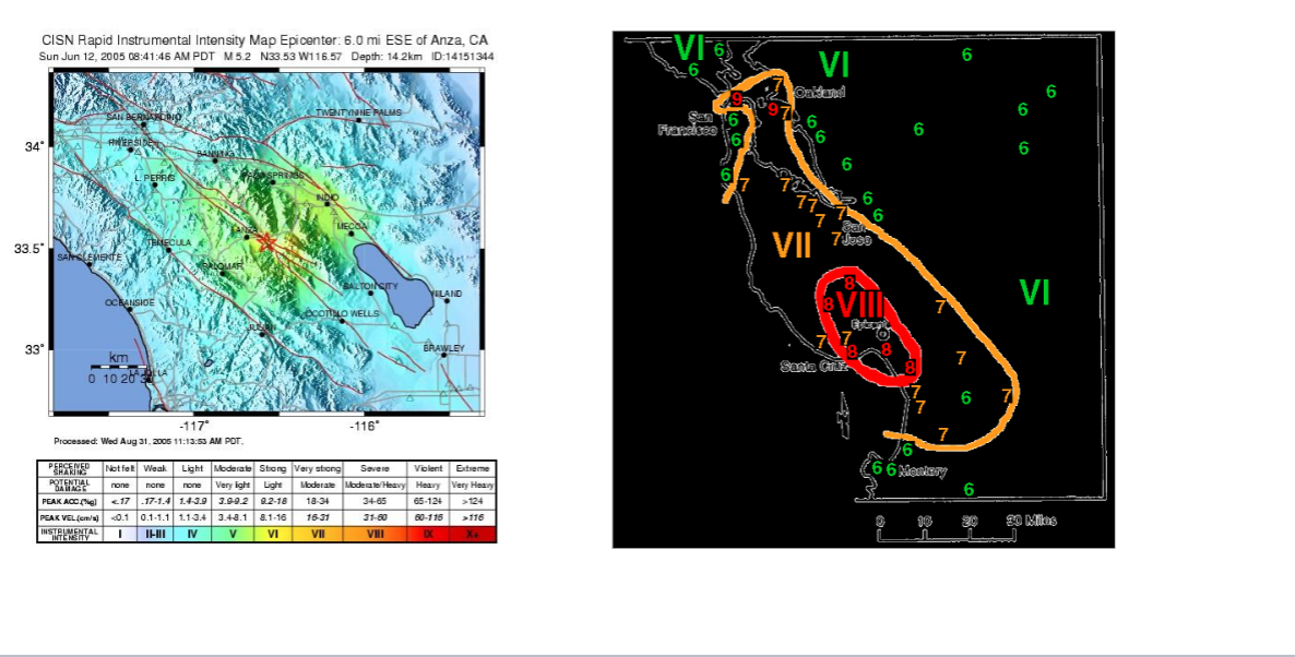
<p><strong>intensity</strong> measures the <em>strength of actual shaking and damage observed at specific locations on the surface</em>. This means a single earthquake has one magnitude, but it spreads out into many different intensities across a map.</p>
10
New cards

Recall the different types of plate

boundaries…

knowt flashcard image
11
New cards

Earthquakes at convergent plate boundaries
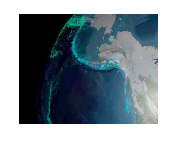
knowt flashcard image
12
New cards

Earthquakes at divergent plate boundaries

knowt flashcard image
13
New cards

What kind of boundary do we have in the

PNW?

Oceanic ridge off the west coast of BC: Divergence of

Pacific plate to the west, Juan de Fuca plate to the east

• Juan de Fuca (oceanic crust) plate is subducting under North America (continental crust) plate

• Potential for a Cascadian subduction zone “megathrust” earthquake
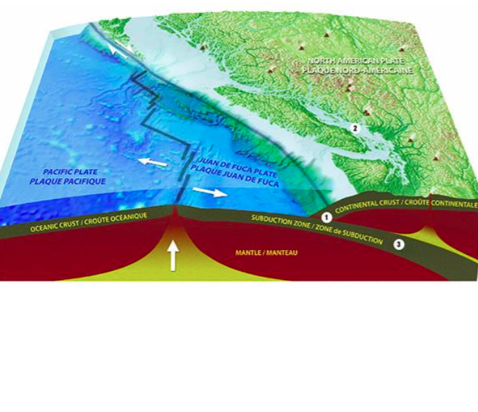
<p>Oceanic ridge off the west coast of BC: Divergence of</p><p>Pacific plate to the west, Juan de Fuca plate to the east</p><p>• Juan de Fuca (oceanic crust) plate is subducting under North America (continental crust) plate</p><p>• Potential for a Cascadian subduction zone “megathrust” earthquake</p>
14
New cards

Why is the underground temperature increase much lower beneath the Strait of Georgia than the Coast Mountains?

  • Strait of Georgia: Sits directly above the cold, subducting oceanic plate, which acts like a massive regional refrigerator and pulls heat downward away from the surface.

  • Coast Mountains: Sits above the volcanic arc, where hot fluids and rising magma heat up the crust from below, pushing high temperatures much closer to the surface.


<ul><li><p><span><strong>Strait of Georgia:</strong> Sits directly above the <strong>cold, subducting oceanic plate</strong>, which acts like a massive regional refrigerator and pulls heat downward away from the surface.</span></p></li><li><p><span><strong>Coast Mountains:</strong> Sits above the <strong>volcanic arc</strong>, where hot fluids and rising magma heat up the crust from below, pushing high temperatures much closer to the surface.</span></p></li></ul><p></p>
15
New cards

Where and why will the next great Cascadia earthquake initiate?

  • The Locked Zone: Where the plates stick due to friction, bending like a tight spring and storing energy.

  • Temperature Boundary (<350°C less than): The start of the locked zone. Rock is cold and brittle (like glass), allowing it to stick and store earthquake stress.

  • Rupture Limit (>400°C greater than 400): The end of the locked zone. Rock is hot and gooey (like taffy), causing it to stretch smoothly and stop the earthquake rip.


<ul><li><p><strong>The Locked Zone:</strong> Where the plates stick due to friction, bending like a tight spring and storing energy.</p></li><li><p><strong>Temperature Boundary (&lt;350°C less than):</strong> The <strong>start</strong> of the locked zone. Rock is <strong>cold and brittle</strong> (like glass), allowing it to stick and store earthquake stress.</p></li><li><p><strong>Rupture Limit (&gt;400°C greater than 400):</strong> The <strong>end</strong> of the locked zone. Rock is <strong>hot and gooey</strong> (like taffy), causing it to stretch smoothly and stop the earthquake rip.</p></li></ul><p></p>
16
New cards

Where do deep earthquakes occur most frequently in a subduction zone setting?

  • Location d (Deep Subducting Slab): Deep earthquakes happen exclusively within the cold, brittle core of the oceanic plate as it plummets deep into the mantle (Wadati-Benioff zone).

  • Why not other locations?

    • Location a (Mid-Ocean Ridge): Rocks are hot, thin, and pulling apart, creating only very shallow earthquakes.

    • Location b & c: These regions produce shallow to intermediate earthquakes along the shallow plate interface and upper trench area.


<ul><li><p><span><strong>Location d (Deep Subducting Slab):</strong> Deep earthquakes happen exclusively within the cold, brittle core of the oceanic plate as it plummets deep into the mantle (<strong>Wadati-Benioff zone</strong>).</span></p></li><li><p><span><strong>Why not other locations?</strong></span></p><ul><li><p><span><strong>Location a (Mid-Ocean Ridge):</strong> Rocks are hot, thin, and pulling apart, creating only very <strong>shallow</strong> earthquakes.</span></p></li><li><p><span><strong>Location b &amp; c:</strong> These regions produce <strong>shallow to intermediate</strong> earthquakes along the shallow plate interface and upper trench area.</span></p></li></ul></li></ul><p></p>
17
New cards

How do landscape materials get from

mountain tops to valley floors?

The processes that move materials into stream,

creeks, and rivers are collectively called mass

movements or mass wasting.

This includes all sorts of slides, slumps, flows, and falls

18
New cards

mass wasting

  • The Trigger: Occurs when downward gravity (shear stress) becomes stronger than the slope's internal strength (shear strength).

Key Causes:

  • Water Pressure: Saturated soil builds up water pressure that pushes dirt grains apart, destroying friction and causing the slope to slide.

  • Earthquakes: Shaking violently jerks the ground, spiking downward stress and instantly breaking the slope's grip.

  • Volcanic Eruptions: Melts ice to create rapid mudflows (lahars) or physically blasts slopes apart.


<ul><li><p><span><strong>The Trigger:</strong> Occurs when <strong>downward gravity (shear stress)</strong> becomes stronger than the <strong>slope's internal strength (shear strength)</strong>.</span></p></li></ul><p><strong>Key Causes:</strong></p><ul><li><p><span><strong>Water Pressure:</strong> Saturated soil builds up water pressure that pushes dirt grains apart, destroying friction and causing the slope to slide.</span></p></li><li><p><span><strong>Earthquakes:</strong> Shaking violently jerks the ground, spiking downward stress and instantly breaking the slope's grip.</span></p></li><li><p><span><strong>Volcanic Eruptions:</strong> Melts ice to create rapid mudflows (lahars) or physically blasts slopes apart.</span></p></li></ul><p></p>
19
New cards

Mass Wasting

• Major types of mass wasting in our area:

1. Falls

2. Flows

3. Slides

The color of each dot identifies the specific type of geological hazard that has occurred there, such as debris flows (green) and rock falls (red), while the size of the dot shows the total number of events recorded at that specific creek or slope. The high density of symbols along the coastline highlights how prone these steep, rain-heavy mountain slopes are to hazardous slope failures.

<p>• Major types of mass wasting in our area:</p><p>1. Falls</p><p>2. Flows</p><p>3. Slides</p><p>The color of each dot identifies the specific type of geological hazard that has occurred there, such as <strong>debris flows</strong> (green) and <strong>rock falls</strong> (red), while the size of the dot shows the total <strong>number of events</strong> recorded at that specific creek or slope. The high density of symbols along the coastline highlights how prone these steep, rain-heavy mountain slopes are to hazardous slope failures.</p>
20
New cards

falls

Falls begin with the detachment of soil or rocks and involve their downward motion by falling, bouncing or rolling with almost no interaction with other materials.

• They are common on very steep slopes (>45º greater than), unlike flows and slides that happen on gentler slopes. They usually happen very rapidly. Topples tend to happen when the slopes are formed by tall blocks which are unstable and can easily rotate.

They can be both extremely slow (mm/yr) and extremely rapid (m/s).
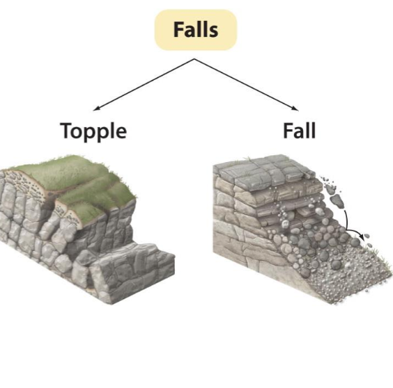
<p>Falls begin with the detachment of soil or rocks and involve their downward motion by falling, bouncing or rolling with almost no interaction with other materials.</p><p>• They are common on very steep slopes (&gt;45º greater than), unlike flows and slides that happen on gentler slopes. They usually happen very rapidly. Topples tend to happen when the slopes are formed by tall blocks which are unstable and can easily rotate.</p><p>They can be both extremely slow (mm/yr) and extremely rapid (m/s).</p>
21
New cards
<p>falls </p>

falls

  • talus or scree slopes

  • Definition: The piles of loose, fallen rock fragments found at the base of most cliffs.

  • Talus vs. Scree:

    • Talus usually means larger rock blocks.

    • Scree refers to smaller, gravel-sized pieces.

How They Form:

  • Angle of Repose: The steepest angle at which a pile of loose material remains stable without sliding down.

  • The Rule: The physical size and shape of the fallen rocks determine this angle. Rough, angular boulders can pile up into much steeper slopes than smooth, tiny pebbles.
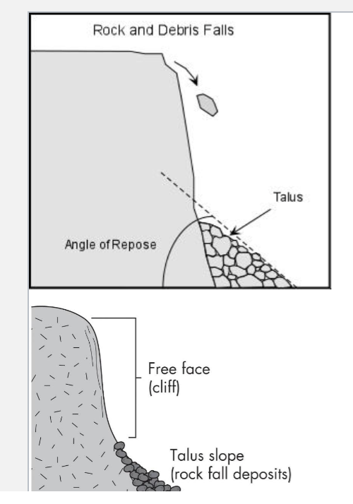

<ul><li><p><span><strong>talus or scree slopes </strong></span></p></li><li><p><span><strong>Definition:</strong> The piles of loose, fallen rock fragments found at the <strong>base of most cliffs</strong>.</span></p></li><li><p><span><strong>Talus vs. Scree:</strong></span></p><ul><li><p><span><strong>Talus</strong> usually means larger rock blocks.</span></p></li><li><p><span><strong>Scree</strong> refers to smaller, gravel-sized pieces.</span></p></li></ul></li></ul><p><strong>How They Form:</strong></p><ul><li><p><span><strong>Angle of Repose:</strong> The steepest angle at which a pile of loose material remains stable without sliding down.</span></p></li><li><p><span><strong>The Rule:</strong> The physical size and shape of the fallen rocks determine this angle. Rough, angular boulders can pile up into much steeper slopes than smooth, tiny pebbles.</span></p></li></ul><p></p>
22
New cards

The Barrier, Garibaldi Provincial Park

The Barrier, a lava cliff at the head of Rubble Creek

drainage and source of the 1855-56 rock avalanche that

reached the Squamish-Whistler corridor.
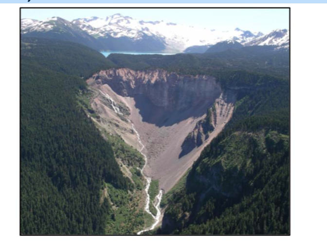
<p>The Barrier, a lava cliff at the head of Rubble Creek</p><p>drainage and source of the 1855-56 rock avalanche that</p><p>reached the Squamish-Whistler corridor.</p>
23
New cards

slides

rotational landslides (slumps)

  • The Mechanism: Material slips over one or more curved surfaces, sliding downward while sticking together and moving as a coherent mass (rather than crumbling apart completely like an avalanche).

  • Ideal Environments: Occurs most frequently in wet, tectonically active, and earthquake-prone areas where slopes are highly saturated and shaken.

  • The Oso Landslide (Washington, USA):

    • The deadliest landslide in US history (43 deaths, 49 structures destroyed).

    • Tragedies like this happen when heavy rainfall saturates an unstable glacial slope, causing it to suddenly collapse as a massive, fast-moving rotational slip.


<p>rotational landslides (slumps) </p><ul><li><p><span><strong>The Mechanism:</strong> Material <strong>slips over one or more curved surfaces</strong>, sliding downward while sticking together and moving as a <strong>coherent mass</strong> (rather than crumbling apart completely like an avalanche).</span></p></li><li><p><span><strong>Ideal Environments:</strong> Occurs most frequently in <strong>wet, tectonically active, and earthquake-prone areas</strong> where slopes are highly saturated and shaken.</span></p></li><li><p><span><strong>The Oso Landslide (Washington, USA):</strong></span></p><ul><li><p><span>The deadliest landslide in US history (43 deaths, 49 structures destroyed).</span></p></li><li><p><span>Tragedies like this happen when heavy rainfall saturates an unstable glacial slope, causing it to suddenly collapse as a massive, fast-moving rotational slip.</span></p></li></ul></li></ul><p></p>
24
New cards

translational slides

  • The Mechanism: Material slides down along straight, flat surfaces rather than curved ones.

  • The Trigger: Usually occurs during periods of heavy rainfall that lubricate the underground sliding surface.

The Rupture Surface (Where it breaks): The exact boundary layer where stable ground separates from the sliding material above it (like an underground slick 'n slide).

  • Direction: Runs parallel to the ground surface at relatively shallow depths.

  • In Rock: Follows natural weaknesses, cracks, or bed layers (discontinuities).

  • In Cohesive Soils: Breaks along a specific, slick weak layer underground.


<ul><li><p><strong>The Mechanism:</strong> Material slides down <strong>along straight, flat surfaces</strong> rather than curved ones.</p></li><li><p><strong>The Trigger:</strong> Usually occurs during <strong>periods of heavy rainfall</strong> that lubricate the underground sliding surface.</p></li></ul><p><strong>The Rupture Surface (Where it breaks): </strong>The exact boundary layer where stable ground separates from the sliding material above it (like an underground slick 'n slide).</p><ul><li><p><strong>Direction:</strong> Runs <strong>parallel to the ground surface</strong> at relatively <strong>shallow depths</strong>.</p></li><li><p><strong>In Rock:</strong> Follows natural weaknesses, cracks, or bed layers (<strong>discontinuities</strong>).</p></li><li><p><strong>In Cohesive Soils:</strong> Breaks along a specific, slick <strong>weak layer</strong> underground. </p></li></ul><p></p>
25
New cards

rock slides

  • The Setup: Heavy gravity overcomes friction, causing the topmost solid rock layer to detach and slide down a hill as a single, unified block.

  • The Crash (Sudden Stop): When that massive sliding block slams into the bottom of the valley or hits a sharp bend, it stops instantly.

  • The Transformation: The extreme force of that sudden stop shatters the solid block into millions of pieces. If mixed with water, it instantly turns into a fast-moving, chaotic debris flow (like wet concrete racing downhill).


<ul><li><p><span><strong>The Setup:</strong> Heavy gravity overcomes friction, causing the topmost solid rock layer to detach and slide down a hill as a <strong>single, unified block</strong>.</span></p></li><li><p><span><strong>The Crash (Sudden Stop):</strong> When that massive sliding block slams into the bottom of the valley or hits a sharp bend, it stops instantly.</span></p></li><li><p><span><strong>The Transformation:</strong> The extreme force of that sudden stop shatters the solid block into millions of pieces. If mixed with water, it instantly turns into a fast-moving, chaotic <strong>debris flow</strong> (like wet concrete racing downhill).</span></p></li></ul><p></p>
26
New cards

flows

Earthflows & Debris Flows

  • The Mechanism: Material moves via internal movements of individual grains flowing within the mass (acting like a thick fluid instead of a solid block).

  • Speed Variations:

    • Fast & Chaotic: Occurs on steep slopes or with high water content (e.g., flash debris flows).

    • Slow & Predictable: Occurs on gradual slope surfaces (typical earthflows).

Characteristics of Earthflows:

  • Soil Type: Most common in heavy, clay-rich soils.

  • Origin: Many start as slumps (rigid blocks) before breaking apart and beginning to flow down-slope.

  • Structure: Often form a complex network of multiple flow lobes that creep forward at different speeds and different times.


<p><span><strong>Earthflows &amp; Debris Flows</strong></span></p><ul><li><p><span><strong>The Mechanism:</strong> Material moves via <strong>internal movements of individual grains</strong> flowing within the mass (acting like a thick fluid instead of a solid block).</span></p></li><li><p><span><strong>Speed Variations:</strong></span></p><ul><li><p><span><strong>Fast &amp; Chaotic:</strong> Occurs on steep slopes or with high water content (e.g., flash debris flows).</span></p></li><li><p><span><strong>Slow &amp; Predictable:</strong> Occurs on gradual slope surfaces (typical earthflows).</span></p></li></ul></li></ul><p><strong>Characteristics of Earthflows:</strong></p><ul><li><p><span><strong>Soil Type:</strong> Most common in heavy, <strong>clay-rich soils</strong>.</span></p></li><li><p><span><strong>Origin:</strong> Many start as <strong>slumps</strong> (rigid blocks) before breaking apart and beginning to flow down-slope.</span></p></li><li><p><span><strong>Structure:</strong> Often form a complex network of <strong>multiple flow lobes</strong> that creep forward at different speeds and different times.</span></p></li></ul><p></p>
27
New cards

debris flow

  • Definition: A fast, soup-like river of wet concrete that rushes down steep slopes and gets channelized (funnelled) into narrow mountain gullies.

  • The Mixture: A chaotic blender of water, rock, soil, trees, and destroyed buildings.

  • Triggers: Happens when bare slopes (like areas burned by wildfires with no root systems) receive sudden, heavy rainfall.

  • Evolution: Often starts at the front edge of a crumbling rock avalanche or a fast slump where crashing rocks mix with water and liquefy.


<ul><li><p><span><strong>Definition:</strong> A fast, soup-like river of <strong>wet concrete</strong> that rushes <strong>down steep slopes</strong> and gets <strong>channelized</strong> (funnelled) into narrow mountain gullies.</span></p></li><li><p><span><strong>The Mixture:</strong> A chaotic blender of <strong>water, rock, soil, trees, and destroyed buildings</strong>.</span></p></li><li><p><span><strong>Triggers:</strong> Happens when <strong>bare slopes</strong> (like areas burned by wildfires with no root systems) receive sudden, <strong>heavy rainfall</strong>.</span></p></li><li><p><span><strong>Evolution:</strong> Often starts at the front edge of a crumbling <strong>rock avalanche</strong> or a fast <strong>slump</strong> where crashing rocks mix with water and liquefy.</span></p></li></ul><p></p>
28
New cards

alberta creek debris flow

knowt flashcard image
29
New cards

snow avalanches

  • The 3 Key Variables: Steepness of slope, stability of the snowpack, and the weather.

  • The Sweet Spot: Most snow avalanches occur on slopes between 35° and 40° (steep enough to slide, but flat enough for snow to pile up).

When Slopes Become Unstable:

  • Wind Loading: Heavy wind piles up deep, unstable snow drifts on the leeward side (the sheltered side) of a ridge.

  • Rapid Precipitation: Fast, heavy snowfall adds massive weight to the slope quicker than the snow pack can bond together.

  • Rapid Warming: Fast-rising temperatures melt the top layers, making the snow very wet and heavy, which destroys internal friction.

  • The Paths: Avalanches tend to follow chutes, which are clear paths cleared out by previous avalanches.


<ul><li><p><span><strong>The 3 Key Variables:</strong> <strong>Steepness of slope</strong>, <strong>stability of the snowpack</strong>, and the <strong>weather</strong>.</span></p></li><li><p><span><strong>The Sweet Spot:</strong> Most snow avalanches occur on slopes between <strong>35° and 40°</strong> (steep enough to slide, but flat enough for snow to pile up).</span></p></li></ul><p><strong>When Slopes Become Unstable:</strong></p><ul><li><p><span><strong>Wind Loading:</strong> Heavy wind piles up deep, unstable snow drifts on the <strong>leeward side</strong> (the sheltered side) of a ridge.</span></p></li><li><p><span><strong>Rapid Precipitation:</strong> Fast, heavy snowfall adds massive <strong>weight</strong> to the slope quicker than the snow pack can bond together.</span></p></li><li><p><span><strong>Rapid Warming:</strong> Fast-rising temperatures melt the top layers, making the snow <strong>very wet and heavy</strong>, which destroys internal friction.</span></p></li><li><p><span><strong>The Paths:</strong> Avalanches tend to follow <strong>chutes</strong>, which are clear paths cleared out by previous avalanches.</span></p></li></ul><p></p>
30
New cards

Factors of Mass Wasting

1. Earth material type

2. Slope angle & topography

3. Climate

4. Vegetation

5. Water

6. Time

31
New cards

earth material type

Affects type & frequency of mass wasting

• Mineral composition (proportions of sand, silt, clay, rock particles)

• Degree of consolidation (process of sediments being compacted into solid rock over large timescales)

• Presence of zones of weakness

E.g. rock falls:

• Where very resistant rock overlies weaker rock, underlying rock will erode faster

E.g. slumps vs. slides

• Slumps: rotational sliding— unconsolidated earth materials

• Slides: slip planes = fractures in all rock types

Slumps rotate backward over a curved surface of loose soil, whereas slides glide flatly down straight cracks in solid rock.

32
New cards

slope and topography

Slope Steepness vs. Relief

  • Steepness (Angle): The tilt of the hill; steeper angles give gravity more pulling force.

  • Relief (Height): The total vertical distance from the top to the bottom of the slope.

  • Why Height Matters: High-relief areas have greater slope lengths, exposing massive volumes of rock to weathering and giving landslides more runway to gain destructive speed.

  • The Record Holders: Pakistan's Nanga Parbat features the world's tallest single mountain face, while Alaska's Mount Hunter features the second tallest.


33
New cards

climate

Climate influences:

• Amount of precipitation

• Seasonality of precipitation

• Type of vegetation

• Abundance of

vegetation

34
New cards

vegetation

How Vegetation Affects Slopes

  • Protective Cover: Leaves block pounding rain, allowing water to infiltrate slowly while minimizing surface erosion.

  • Root Anchoring: Deep roots act like underground rebar, adding cohesion and increasing the slope's shear strength against landslides.

  • Added Weight: Heavy trees add massive weight to the hillside; this can be a negative factor because it gives gravity a stronger downward pull.


35
New cards

water

  • Immediate Flash Slips: Heavy downpours quickly saturate surface dirt, spiking water pressure to cause instant slips and fast debris flows.

  • Delayed Deep Slumps: Rainfall slowly seeps deep underground over years, weakening hidden clay layers to trigger slumps decades later.

  • Basal Undercutting: Rivers or ocean waves wash away soil from the base of a slope, stripping away its bottom structural support. cutting bottom support


36
New cards

time

Environmental Triggers & Levels of Mass Movement

  • Timelines of Slope Stability: Slopes are constantly changed by short-term triggers like heavy rainfall (spikes water pressure), earthquakes (shakes ground), and human land use (alters water flow), as well as long-term shifts over thousands of years like losing tree roots (cohesion) or soil building up thicker.

The Two Levels of Mass Movement:

  • A. The Obvious (Rapid): Catastrophic, fast-moving landslides that you can see instantly, such as houses collapsing down a cliff face.

  • B. The Hidden (Slow Creep): Tiny, invisible movements underground that cannot be easily seen day-to-day, but over decades, they warp the landscape, bending fences and tilting telephone poles.


37
New cards

The Obvious – Rapid Mass Movements

knowt flashcard image
38
New cards

he Hidden – Slow Mass Movements

Soil Creep

Slow downhill movement of

soil and rock mass based on

wetting and drying (or freezing

and thawing) cycles

<p>Soil Creep</p><p>Slow downhill movement of</p><p>soil and rock mass based on</p><p>wetting and drying (or freezing</p><p>and thawing) cycles</p>
39
New cards

soil creep

knowt flashcard image



