Task C. Weather Information
 Call Kai
 Learn
 Practice Test
 Spaced Repetition
 Match
 Flashcards
 Knowt Play
1/175

There's no tags or description
Looks like no tags are added yet.
176 Terms
Is there an official source of weather which meets the preflight requirements of 91.103?
No, 91.103 does not list a specific source to meet that requirement
What are some weather sources?
Flight Service, Foreflight/Garmin Pilot, 1-800-WXBRIEF, aviationweather.gov, etc
What are the types of weather briefings?
AIM 7-1-5
Standard: a comprehensive briefing when departing within 6 hours, and have not received a previous briefing
Abbreviated: when you need information to supplement weather data, update a previous weather briefing, or for one or two specific items
Outlook: for early planning, 6 or more hours before the flight
What information is required when requesting a weather briefing?
AIM 7-1-5
Type of flight plan
Aircraft Identification
Aircraft Type
Departure Point and ETD
Route of Flight and ETE
Destination and ETA
Flight Altitudes
What is an aviation routine weather report (METAR)?
Valid weather information issued every hour, usually 55 minutes past the hour of weather observed at the station for the past hour
What are the types of METARs?
PHAK Chap. 13
Regular METAR: Issued on a time interval
Special Issuance (SPECI): Issued as needed for rapidly changing weather conditions, aircraft mishaps, or other critical info
What conditions warrant a SPECI?
PHAK Chap. 13: Conditions like TS, Squalls, or a wind shift of ≥45° in less than 15 minutes with the speed of ≥10 kts.
What is a METAR modifier?
PHAK Chap. 13: Denotes what source supplied the information in the METAR:
- AO1: Automated observation, no precip. discriminator
- AO2: Automated observation, with precip. discriminator
- COR: Correction to an earlier report
Define the METAR descriptor abbreviations: MI, BC, DR, BL, SH, TS, FZ, and PR
MI: Shallow
BC: Patches
DR: Low drifting
BL: Blowing
SH: Showers
TS: Thunderstorm
FZ: Freezing
PR: Partial
Define the METAR precipitation abbreviations: DZ, RA, SN, SG, IC, PL, GR, GS, and UP
DZ: Drizzle
RA: Rain
SN: Snow
SG: Snow grains
IC: Ice crystals
PL: Ice pellets
GR: Hail
GS: Small hail
UP: Unknow precipitation
Define the METAR obscuration abbreviations: BR. FG, FU, DU, SA, HZ, PY, and VA
BR: Mist
FG: Fog
FU: Smoke
DU: Dust
SA: Sand
HZ: Haze
PY: Spray
VA: Volcanic Ash
Define the METAR abbreviations: PO, SQ, FC, +FC, SS, and DS
PO: Dust/sand
SQ: Squalls
FC: Funnel cloud
+FC: Tornado or waterspout
SS: Sandstorm
DS: Dust storm
Define the METAR cloud abbreviations: ACC, ACSL, CBMAM, CCSL, and SCSL
ACC: Altocumulus castellanus
ACSL: Altocumulus standing lenticular
CBMAM: Cumulonimbus Mammatus
CCSL: Cirrocumulus standing lenticular
SCSL: Stratocumulus standing lenticular
METAR TJSJ 092356Z 13005KT 7SM -TSRA FEW028CB FEW040 SCT060 27/24 A3002 RMK AO2 SLP165 FRQ LTGICCGCA S-W TS S-W MOV W P0026 30024 60027 70125 T02670244 10311 20267 403240253 53012 $
Define: 30024, 60027, 70125, 10311, 20267, 403240253 and 53012
Precipitation:
30024: 3-hour precipitation, .24 inches
60027: 6-hour precipitation, .27 inches
70125: 24-hour precipitation, 1.25 inches
Temperature:
10311: 6-hour maximum temp., 31.1°C
20267: 6-hour minimum temp., 26.7°C
403240253: 24 hour max. and min. temp.
- Max: 32.4°C
- Min: 25.3°C
Pressure:
53012: 3 hourly pressure tendency, change of 1.2 hPa
What's a pilot weather report (PIREP)?
Valuable information regarding actual conditions that exist in the air given by pilots
What conditions constitute a routine PIREP (UA)?
Ceilings
What conditions constitute an urgent PIREP (UUA)?
Tornadoes, funnel clouds, or waterspouts
Severe/extreme turbulence
Clear air turbulence
Severe icing
Hail
Low-level wind shear
Volcanic eruption
Any conditions deemed hazardous
When should a pilot submit a PIREP?
91.183: When flying IFR and the pilot comes across conditions not forecasted
What's a surface analysis chart?
Depicts an analysis of current surface weather including:
- Pressure systems, fronts, temps/dew points, wind direction and speeds, and obscurations
What's a ceiling and visibility chart (CVA)?
No longer exists, now part of the Graphical Forecast for Aviation (GFA)
What's a terminal aerodrome forecast (TAF)?
A forecast of conditions expected to exist at the specified time period within a 5SM radius of the center of the airports runway complex
When are TAF's issued and valid for?
Issued every 6 hours, valid for 24 hours (30 for larger airports)
Define FM, TEMPO, PROB##, and BECMG in a METAR
FM: Significant change is expected at the "FM" time specified
TEMPO: Temporary fluctuations of weather expected to last less than an hour
PROB##: the probability in percentage (30 or 40) of the described conditions to appear in the specified hours
BECMG: Changes expected in the specified time period
What's a graphical forecast for aviation (GFA)?
A visual depiction of observational data, forecasts, and warnings that can be viewed 18 hours in the past and into the future
- Clouds, flight categories, precip., icing, wind, and graphical information

Identify
Cold front

Identify
Warm front

Identify
Stationary front

Identify
Occluded front

Identify
Trough

Identify
Dry line

Identify
Squall

Identify
Frontolysis

Identify
Frontogenesis

Identify
Ridge

Identify
Tropical wave

Identify
Change of front type

Identify
High pressure system

Identify
Low pressure system

Identify
Tropical storm

Identify
Hurricane

Identify if it had "T.D. XXX" on the right hand side
Tropical depression
What's a wind and temperature aloft forecast (FB)?
A forecast of wind speed (knots), direction (true), and temperature (celsius) at low to high altitudes
What altitudes have a wind and temperature aloft forecast?
From 3,000 ft to 53,000 ft MSL
When are wind and temperature aloft forecast issued and valid for?
Issued every 6 hours (4x daily), with each one valid for 6 hours

Why are some stations not reporting winds or temperature at specific altitudes?
Wind is excluded from station with elevations within 1,500 ft. MSL while temperature is within 2,500 ft. MSL from the forecast altitude,
What's a convective outlook (AC)?
A narrative and graphical depiction of severe thunderstorm threats across the U.S.
When are convective outlook's issued and valid for?
Day 1: Risk of severe weather valid for 24 hours, issued 5x a day
Day 2: Risk of severe weather valid for 24 hours, issued 2x a day
Day 3: Risk of severe weather valid for 24 hours, issued daily
Day 4-8: Risk of severe weather valid for 24 hours, issued daily
What defines a thunderstorm as severe?
When it contains one or more of the following:
- Hail 1" or greater
- Winds gusting >50 knots
- Tornado
What's a Hazardous Inflight Weather Advisory System (HIWAS)?
An automated continuous broadcast of hazardous weather information over selected VOR navigational aids (NAVAIDs)
- Info including convective/regular SIGMETs, AIRMETs, and PIREPs

How can a pilot identify a VOR that is capable of HIWAS?
An "H" annotation inside the VOR information box
What's an Airmen's Meteorological Information (AIRMET/WA)?
Advises of light to moderate weather conditions that may be hazardous to all aircraft, but with a focus on smaller aircraft
What's the difference between an AIRMET and G-AIRMET?
AIRMET: A textual description using VORs to define the affected area
G-AIRMET: A graphical depiction of a hazard using lat/long coordinates
When are AIRMETs and G-AIRMETs issued and valid for?
AIRMET: Issued every 6 hours, valid for 6 hours
G-AIRMET: Issued every 3 hours, valid for 3 hours
What are types of G-AIRMETs?
Sierra: IFR conditions and mountain obscurations
Tango: Moderate turbulence and LLWS
Zulu: Icing and FZ levels
What are the conditions for a G-AIRMET to be issued?
If any of the Sierra, Tango, or Zulu conditions are expected over an area at least 3,000 square miles
What's a Significant Meteorological Information (SIGMET/WS)?
Advises of severe weather conditions that may be hazardous to all aircraft
When are SIGMET's issued and valid for?
Issued as needed, valid for 4 hours (6 hours for hurricanes)
What/when is SIGMET issued for?
If any of the conditions are expected over an area at least 3,000 square miles, or an area judged to have an impact on aircraft safety:
- Severe icing
- Severe/Extreme turbulence or CAT
- Dust/sandstorms
- Volcanic ash
What's a Convective SIGMET (WST)?
Advises of severe convective weather conditions that may be hazardous to all aircraft
- Only issued for the CONUS
- Contains either an observation and a forecast, or only a forecast
When are Convective SIGMETs issued and valid for?
Issued 55 minutes past the hour, valid for 2 hours
What is a convective SIGMET issued for?
1. Severe thunderstorms due to:
- Surface winds ≥ 50 knots
- Hail at the surface >3/4" in diameter
2. Tornados
3. Embedded thunderstorms
4. Line of thunderstorms at least 60 mi. long, with thunderstorms affecting 40% of its length
5. Thunderstorms producing heavy or greater precipitation affecting 40% of an area at least 3,000 square miles
What is implied by a convective SIGMET?
Severe or greater turbulence, severe icing, and LLWS
What's the atmosphere composed of?
Nitrogen: 78%
Oxygen: 20%
Argon: 0.9%
Carbon Dioxide: 0.042%
What atmospheric layer contains almost all of the Earth's weather?
Troposphere
What's a tropopause?
Layer above the troposphere, past the tropopause the air temperature increases with altitude
What's the standard pressure and temperature?
29.92 inHg/1013.25 hPa and 15°C/59°F
Standard pressure and temperature lapse rate
1" Hg per 1,000 ft. and 2°C per 1,000 ft.
What is atmospheric stability?
The atmosphere's ability to resist upwards displacement
What forces affect wind direction and speed
Pressure gradient force (PGF), Coriolis force, and surface friction
What's a pressure gradient force (PGF)?
The force which directs wind from high to low pressure
What does a strong pressure gradient indicate in terms of wind?
Closer isobars means the pressure gradient changes rapidly, which indicates stronger winds
What's is coriolis force (CF)?
A force as a result of the Earth's rotation, deflects winds to the right in the Northern Hemisphere, and to the left in the Southern Hemisphere
What's surface friction force?
Friction caused by wind flowing over terrain/obstruction, it slows the wind and increases with with rougher terrain or wind speeds
- Affects wind up to 2,000 ft. AGL
Why does surface friction affect how winds flow relative to the isobars?
At the surface all three forces affect wind, as frictional force slows the wind down it also decreases Coriolis force, but does not affect PGF. As a result, wind flows at an angle at the surface
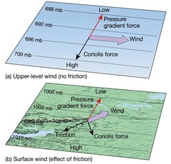
How do winds flow relative to the isobars at altitude?
Parallel to the isobars
What's an isobar?
A line of equal pressure
What's a sea breeze?
Wind that blows from sea to land caused by the cold, high pressure air over the sea flowing to the hot, low pressure air over the land
- Common on calm, sunny, summer days
What's a sea breeze front?
A miniature version of a cold front caused by a sea breeze. When cold, moist air from the sea moves inland
- Can cause wind shifts and cumulus clouds
What's a land breeze?
Wind that blows from land to sea caused by the cold, high pressure air over the land flowing to the hot, lower pressure air over the sea
- Common at night and early in the morning
Why do land/sea breeze's form?
Land heats up and cools down faster than the sea, while the sea heats up and cools down slower
What's a lake breeze?
A sea breeze but with a lake, strength depends on lake depth (shallower lake warms up quicker making the lake breeze weaker)
What's a valley breeze?
During the day, the air touching the mountains heats up quicker than the air above the valley creating a pressure gradient force which causes the cold valley air (high pressure) to flow to the hot mountain air (low pressure)
- Clouds may develop over the peaks
What's a mountain breeze?
At night, the air above the surface of the mountains is cooled faster than the air above the valley, creating a pressure gradient force which blows wind downward. The cold air (high pressure) flows to the warm air (low pressure) above the mountains in the valley
What's a wind gust?
A wind fluctuation of wind speed with a variation of 10 knots or more between peaks and lulls
What's wind shear?
The sudden, drastic change in wind speed and/or direction over a small area
- Can be at any altitude or direction
- Changes of 15 knots or vertical speeds of 500 fpm is categorized as severe
What's a non-convective LLWS?
Wind shear that occurs within 2,000 ft AGL
What's a mountain/lee wave?
When strong winds flow over/around mountains it can cause stable air to oscillate on the leeward side of the mountain
What's a temperature inversion?
When temperature increases with altitude
What's a surface-based inversion?
The air touching the ground at night cools faster than the air higher above it. As a result there's cold air at the surface, and hotter air above it
What's relative humidity?
The percentage value of how close an air parcel is to being saturated
- Anything less than 100% is unsaturated
How can you increase the relative humidity of an air parcel without affecting its water vapor content?
Decreasing its temperature
What's a dewpoint?
The temperature an air parcel must be cooled to in order to condense into water (dew)
What's a dewpoint depression/spread?
Difference in temperature and dewpoint
How does precipitation form?
A process called collision coalescence, when droplets of different sizes stick to each other eventually becoming heavy enough to fall
What's an air mass?
A large body of air with generally uniform temperature and humidity
What's an air mass source region?
Where an air mass originates from
What are the five types of air masses?
Continental Arctic (cA): Cold, dry
Continental Polar (cP): Cold, dry
Continental Tropical (cT): Hot, dry
Maritime Polar (mP): Cool, moist
Maritime Tropical (mT): Warm, moist
What's a front?
The boundary of an air mass
What's a warm front?
When a warm mass of air advances, replaces, and slides over a body of colder air. As the warm air is lifted, the temperature drops and condensations occurs
- Stable
- Fog, cirriform, stratiform, and light rain
How fast does a warm front?
10 to 25 mph