E&E 151 S Introductory Geology: Chapters 11.1 - 11.5 (Groundwater Pt. 1) Visualization Study
 Call Kai
 Learn
 Practice Test
 Spaced Repetition
 Match
 Flashcards
 Knowt Play
1/17

There's no tags or description
Looks like no tags are added yet.
Name | Mastery | Learn | Test | Matching | Spaced | Call with Kai | Chat |
|---|
No analytics yet
Send a link to your students to track their progress
18 Terms
Unsaturated Zone (Vadose Zone)
What is the term/concept being visualized in this image?
Definition: The region above the water table where pore spaces contain a mix of air and water held by surface tension. Plant roots extract soil moisture from the top of this zone.

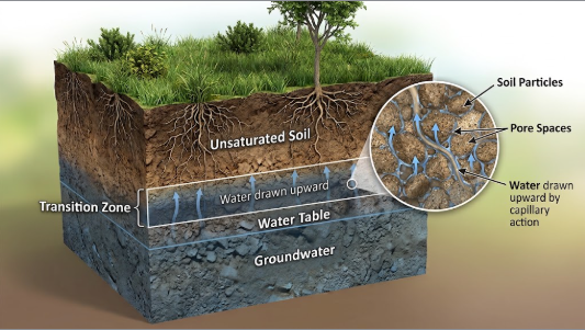
Capillary Fringe
What is the term/concept being visualized in this image?
Definition: A thin transition band directly above the water table where water is drawn upward against gravity by surface tension.
Water Table
What is the term/concept being visualized in this image?
Definition: The upper boundary line/surface of the saturated zone.

Saturated Zone (Phreatic Zone)
What is the term/concept being visualized in this image?
Definition: The subsurface region where 100% of all openings and pores are filled with water.

Perched Water Table
What is the term/concept being visualized in this image?
Definition: A localized body of groundwater held above the main water table by an underlying impermeable lens (aquitard).

Unconfined Aquifer (Water Table Aquifer)
What is the term/concept being visualized in this image?
Definition: An aquifer exposed to the surface, partly filled, whose water table can rise and fall freely with rainfall and pumping.

Confined Aquifer (Artesian Aquifer)
What is the term/concept being visualized in this image?
Definition: An aquifer completely filled with pressurized water, bounded above and below by impermeable confining layers (aquitards).

Potentiometric Surface
What is the term/concept being visualized in this image?
Definition: The imaginary elevation line/surface to which pressurized groundwater would rise naturally in a confined aquifer system.

Artesian Well
What is the term/concept being visualized in this image?
Definition: A well drilled into a confined aquifer where internal pressure forces water to rise above the top of the aquifer bed.
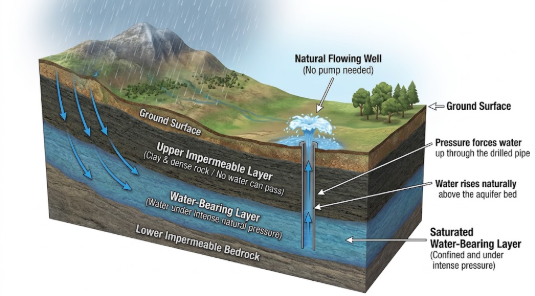
Flowing Well
What is the term/concept being visualized in this image?
Definition: An artesian well where fluid pressure is high enough to push water completely above the land surface without pumping (e.g., the Dakota Sandstone).

Cone of Depression
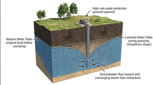
What is the term/concept being visualized in this image?
Definition: An inverted, cone-shaped drawdown pattern created around a well when groundwater is pumped out faster than it recharges.
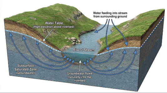
Gaining Stream
What is the term/concept being visualized in this image?
Definition: A stream that gains water from the surrounding saturated zone (groundwater flows into the riverbed).
Losing Stream
What is the term/concept being visualized in this image?
Definition: A stream that loses surface water downward into the underlying saturated zone (recharging the water table).

Spring
What is the term/concept being visualized in this image?
Definition: A natural exit point where groundwater flows out of rock onto the land surface (e.g., Vasey's Paradise in Marble Canyon).

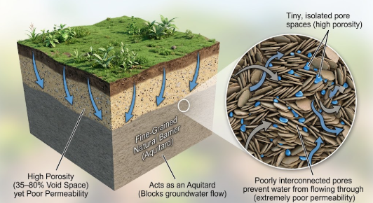
Clay
What is the term/concept being visualized in this image?
Definition: High porosity (35-80%) but poor permeability because the tiny pores are poorly interconnected (functions as an aquitard).
Gravel & Sand
What is the term/concept being visualized in this image?
Definition: High porosity (20-50%) and excellent permeability (ideal aquifers).

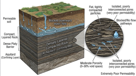
Shale
What is the term/concept being visualized in this image?
Definition: Moderate porosity (0-30%) but very poor permeability (functions as an aquitard/confining bed).
Crystalline Rock
What is the term/concept being visualized in this image?
Definition: Low porosity (0-10%) and poor permeability unless fractured.
