runoff & flood (3)

0.0(0)
Studied by 0 people
call kaiCall Kai
learnLearn
examPractice Test
spaced repetitionSpaced Repetition
heart puzzleMatch
flashcardsFlashcards
GameKnowt Play
Card Sorting

1/29

encourage image

There's no tags or description

Looks like no tags are added yet.

30 Terms

1
New cards

flooding generating mechanisms

  • rainfall

  • spring-summer snowmelt

  • spring-summer snowmelt w/ rain

  • glacier melt

  • glacier melt w/ rain

  • winter rain-on-snow

  • glacier outburst floods

  • “geomorphic” floods

  • etc.


2
New cards

rain-dominated regime: atumn-winter floods graph

  • rain-dominated regime: streamflow controlled by rain

  • atumn-winter floods: heavy rainfall & already saturated soils → increased runoff → higher stream discharge → flooding
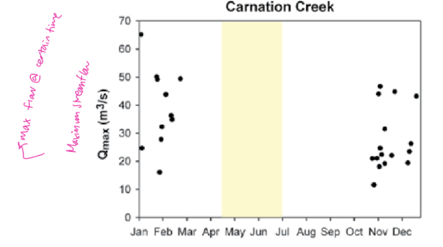

<ul><li><p>rain-dominated regime: streamflow controlled by rain</p></li><li><p>atumn-winter floods: heavy rainfall &amp; already saturated soils → increased runoff → higher stream discharge → flooding </p></li></ul><p></p>
3
New cards

snow-dominated regime: spring summer floods graph

  • snow dominated: streamflow controlled by snowmelt

  • spring-summer floods: rising temps melt accumulated winter snow → increased runoff → higher stream discharge → flooding

  • peak flows occur may-jun


<ul><li><p>snow dominated: streamflow controlled by snowmelt</p></li><li><p>spring-summer floods: rising temps melt accumulated winter snow → increased runoff → higher stream discharge → flooding </p></li><li><p>peak flows occur may-jun</p></li></ul><p></p>
4
New cards

hybrid regime: spring-summer and atumn floods

  • hybrid regime: streamflow controlled by both snow&rainfall

  • spring-summer floods: snowmelt causes increased runoff

  • atumn floods: heavy rainfall and saturated soils increase streamflow

  • peak flows occur may-jun and sept-nov


<ul><li><p>hybrid regime: streamflow controlled by both snow&amp;rainfall</p></li><li><p>spring-summer floods: snowmelt causes increased runoff</p></li><li><p>atumn floods: heavy rainfall and saturated soils increase streamflow </p></li><li><p>peak flows occur may-jun and sept-nov</p></li></ul><p></p>
5
New cards

what is flood frequency analysis

  • used to relate magnitude of extreme runoff or river flow events to their frequency of occurrence through the use of probability distribution functions

  • historical records provide essential info

    • predict reurrence interval of hydrological extremes

      • predict future floods → management & mitigation


6
New cards

flood frequency analysis: exceedance probability definition

probability in any year that a given annual maximum flow (x) will be equaled or exceeded


<p>probability in any year that a given annual maximum flow (x) will be equaled or exceeded </p><p></p>
7
New cards

flood frequency analysis: return period definition

mean length of time between events that equal or exceed a given value

<p>mean length of time between events that equal or exceed a given value </p>
8
New cards

define flow duration analysis

conducted by ranking event discharge values and estimating the % of time the discharge amount of exceeded


9
New cards

flow duration analysis graph

flow duration curve shows % of time a given discharge is equaled or exceeded

  • high discharge = low exceedance fraction

    • exceedamce fraction is the fraction/% of time that river discharge is greater than a specific flow value

  • low discharge = high exceedance fraction

  • describes how frequently different flow magnitude occur NOT timing of floods
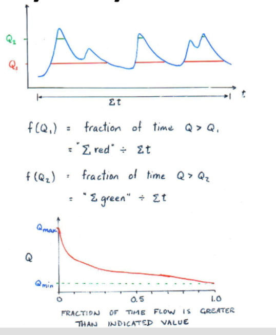

<p>flow duration curve shows % of time a given discharge is equaled or exceeded</p><ul><li><p>high discharge = low exceedance fraction</p><ul><li><p>exceedamce fraction is the fraction/% of time that river discharge is greater than a specific flow value </p></li></ul></li><li><p>low discharge = high exceedance fraction</p></li><li><p>describes how frequently different flow magnitude occur NOT timing of floods </p></li></ul><p></p>
10
New cards

extreme value analysis

  • low flows

  • peak flows

    • partial duration series

      • analyze all peak flows above some threshold (e.g., flow that will scour fish habitat or overflow the channel) annual extreme series

    • annual extreme series

      • analyze only the highest flow each year


11
New cards

assumptions made during flood frequency analysis

  • all flow events are independent (defined next)

  • all flow events are due to same mechanism

  • flood probabilities do not change through time


12
New cards

event independence

when conducting an extreme value analysis, only “independent” events should be included (an assumption made to conduct a flood frequency analysis)

  • independent = magnitude of one event has no influence on the magnitude of another event


13
New cards

good graph

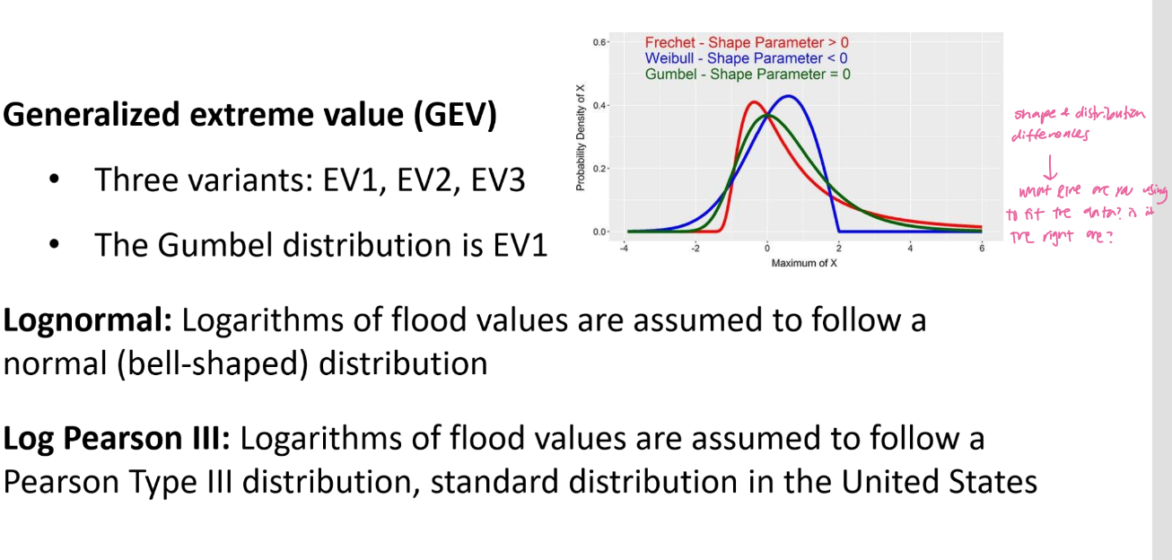
comparison of annual extreme and partial duration peak flow series
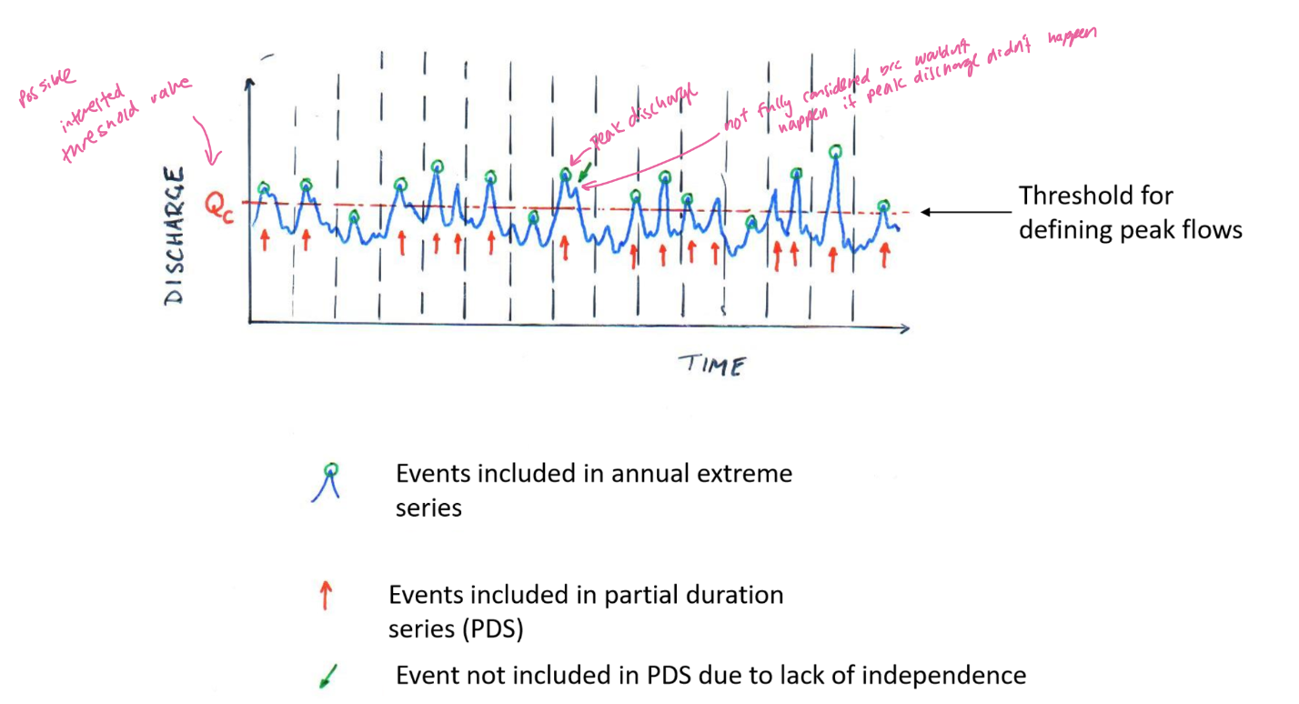
<p>comparison of annual extreme and partial duration peak flow series </p>
14
New cards

flood frequency analysis: approaches

fitting a probability distribution to annual peak flow series → gives annual measurements

  • graphical (visual, uses graph paper)

  • numerical (more obejctive)

    • methods of moments (mean, variants)

    • maximum likelihood (finds parameters that max liklihood of oberving data)

    • L-moments (combination of…)


15
New cards

flood frequency analysis:

graphical approach

knowt flashcard image
16
New cards

flood frequency analysis:

methods of moments approach

knowt flashcard image
17
New cards

probability of distribution

knowt flashcard image
18
New cards
<p>graph method example </p>

graph method example

knowt flashcard image
19
New cards

risk analysis

what is the probability that a T-year event (event w/ certain magnitude) will occur at least once in a period of “n” years?

  • P = probability that flood occurs at least once during n yrs

  • T = return period (e.g., 10-yr flood)

  • n = number of yrs considered

  • 1/T = probability of that flood occuring in any single yr

  • 1-1/T = probability of the flood NOT occuring in a single yr

  • (1-1/T)^n = probability of the flood NOT occuring over n yrs

  • 1 - (1 - 1/T)^n = probability of the flood occuring at least once over n yrs


<p>what is the probability that a T-year event (event w/ certain magnitude) will occur at least once in a period of “n” years? </p><ul><li><p>P = probability that flood occurs at least once during n yrs</p></li><li><p>T = return period (e.g., 10-yr flood)</p></li><li><p>n = number of yrs considered </p></li><li><p>1/T = probability of that flood occuring in any single yr </p></li><li><p>1-1/T = probability of the flood NOT occuring in a single yr </p></li><li><p>(1-1/T)^n = probability of the flood NOT occuring over n yrs</p></li><li><p>1 - (1 - 1/T)^n = probability of the flood occuring at least once over n yrs </p></li></ul><p></p>
20
New cards
<p>in-class risk analysis example equation</p>

in-class risk analysis example equation

answer: ~0.096

21
New cards

flood routing

  • tracks how a flood wave moves through a watershed from its source to the downstream outlet / POI


22
New cards

flood routing temporal lag

temporal lag accounting for time it takes for transition of:

  • (source) active melting snow → runoff → streamflow → downstream to outlet/POI (leaving system)

    • along the way could also add to GW, evaporate, etc (slowed down as it finally leaves channel storage)

  • can be also be temporarily delayed by bank storage


<p>temporal lag accounting for time it takes for transition of:</p><ul><li><p>(source) active melting snow → runoff → streamflow → downstream to outlet/POI (leaving system)</p><ul><li><p>along the way could also add to GW, evaporate, etc (slowed down as it finally leaves channel storage) </p></li></ul></li><li><p>can be also be temporarily delayed by bank storage</p></li></ul><p></p>
23
New cards

flood routing (temporal lag) bank storage

water from the river enters riverbanks when river level rise, then slowly returns to the channel as levels fall

→ impacts flood routing !

<p>water from the river enters riverbanks when river level rise, then slowly returns to the channel as levels fall </p><p>→ impacts flood routing !</p>
24
New cards

lillooet river case study (geomorphic flood event)

landslide (debris flow from some amount of water input causing instability) → river blockage (as it material flows into meager creek → dam) → water accumulation → dam failure → outburst flood → erosion + sediment deposition → channel change

25
New cards

geomorphic hazards associated with glacier retreat

  • sagging of over-steepended, de-buttressed slopes, → Affliction glacier

  • exposure of unstable sediments → capricorn creek


26
New cards

How does ppt become streamflow? → how did it get there from the hillslope ? 

stream runoff generation mechanisms (3)

27
New cards

stream runoff generation mechanisms (3)

  1. infiltration excess overland flow

  2. saturation excess overland flow

  3. shallow subsurface stormflow / groundwater flow / baseflow


28
New cards

explain stream runoff generation mechanism:

  1. infiltration excess overland flow


  • ‘Hortonian’ overflow 

  • Ppt arrives but can't infiltrate fast enough, flows over ground surface, flows into streamflow 

  • Occurs when rainfall intensity exceeds the infiltration capacity 

  • ‘Saturation from above’

  • Rapid!!!!

  • Common in: 

    • Places with lots of impervious cover 

      • Like an urban environment with concrete covering ground/ concrete buildings 

    • Semi-arid environments 

    • Infiltration capacity reduced due to anthropogenic activities 

      • Compaction 

      • Freezing of ground surface (covers ground) 

      • After fire (hydrophobic soil) 


<ul><li><p><span style="background-color: transparent;">‘Hortonian’ overflow&nbsp;</span></p></li><li><p><span style="background-color: transparent;">Ppt arrives but can't infiltrate fast enough, flows over ground surface, flows into streamflow&nbsp;</span></p></li><li><p><span style="background-color: transparent;">Occurs when rainfall intensity exceeds the infiltration capacity&nbsp;</span></p></li><li><p><span style="background-color: transparent;">‘Saturation from above’</span></p></li><li><p><span style="background-color: transparent;">Rapid!!!!</span></p></li><li><p><span style="background-color: transparent;">Common in:&nbsp;</span></p><ul><li><p><span style="background-color: transparent;">Places with lots of impervious cover&nbsp;</span></p><ul><li><p><span style="background-color: transparent;">Like an urban environment with concrete covering ground/ concrete buildings&nbsp;</span></p></li></ul></li><li><p><span style="background-color: transparent;">Semi-arid environments&nbsp;</span></p></li><li><p><span style="background-color: transparent;">Infiltration capacity reduced due to anthropogenic activities&nbsp;</span></p><ul><li><p><span style="background-color: transparent;">Compaction&nbsp;</span></p></li><li><p><span style="background-color: transparent;">Freezing of ground surface (covers ground)&nbsp;</span></p></li><li><p><span style="background-color: transparent;">After fire (hydrophobic soil)&nbsp;</span></p></li></ul></li></ul></li></ul><p></p>
29
New cards

explain stream runoff generation mechanism:

  1. Saturation excess overland flow


  • ‘Dunne overflow’ 

  • Water infiltrates through unsaturated zone → encounters GW table (subsurface saturates) → causes water table to rise → rises to point where it intersects ground surface → water exfiltrates and will flow over surface as surface overland flow into channel 

  • ‘Saturation from below’ 

  • Common in

    • Humid environments 

    • Places covered in grasslands/forest

    • Convergent parts of landscape 

      • Ridgetop down to a hollow (downslope areas) 

      • Above channel head 

  • Pretty fast

    • Flashy flow ???

    • Moves quicker aboveground than below ofc 


<ul><li><p><span style="background-color: transparent;">‘Dunne overflow’&nbsp;</span></p></li><li><p><span style="background-color: transparent;">Water infiltrates through unsaturated zone → encounters GW table (subsurface saturates) → causes water table to rise → rises to point where it intersects ground surface → water exfiltrates and will flow over surface as surface overland flow into channel&nbsp;</span></p></li><li><p><span style="background-color: transparent;">‘Saturation from below’&nbsp;</span></p></li><li><p><span style="background-color: transparent;">Common in</span></p><ul><li><p><span style="background-color: transparent;">Humid environments&nbsp;</span></p></li><li><p><span style="background-color: transparent;">Places covered in grasslands/forest</span></p></li><li><p><span style="background-color: transparent;">Convergent parts of landscape&nbsp;</span></p><ul><li><p><span style="background-color: transparent;">Ridgetop down to a hollow (downslope areas)&nbsp;</span></p></li><li><p><span style="background-color: transparent;">Above channel head&nbsp;</span></p></li></ul></li></ul></li><li><p><span style="background-color: transparent;">Pretty fast</span></p><ul><li><p><span style="background-color: transparent;">Flashy flow ???</span></p></li><li><p><span style="background-color: transparent;">Moves quicker aboveground than below ofc&nbsp;</span></p></li></ul></li></ul><p></p>
30
New cards

explain stream runoff generation mechanism:

  1. Shallow subsurface stormflow /  groundwater flow / baseflow 


  • Made up of all the subsurface pathways that water can take to the channel  

  • Groundwater table rises (in response to infiltrating water from unsaturated zone) → creates an increased head gradient to deliver more water to the channel 

  • Could also… have a layer of decrease hydraulic conductivity (like the soil bedrock boundary → may get perched water table on top of the boundary (still in the subsurface, still flowing as subsurface flow down to the channel) 

  • Slower than overland flow but can still be quick 

  • One example that triggers runoff generation rapidly: may have (above the water table) significant capillary fringe → tension saturated, needs little more water from vertical unsaturated flow to cause positive pressure → rapidly become GW flow 

  • Thicker zone will steepen head gradient towards the channel and increases thickness of hillslope aquifer system → transmissivity increases as you move towards the channel


<ul><li><p><span style="background-color: transparent;">Made up of all the subsurface pathways that water can take to the channel&nbsp;&nbsp;</span></p></li><li><p><span style="background-color: transparent;">Groundwater table rises (in response to infiltrating water from unsaturated zone) → creates an increased head gradient to deliver more water to the channel&nbsp;</span></p></li><li><p><span style="background-color: transparent;">Could also… have a layer of decrease hydraulic conductivity (like the soil bedrock boundary → may get perched water table on top of the boundary (still in the subsurface, still flowing as subsurface flow down to the channel)&nbsp;</span></p></li><li><p><span style="background-color: transparent;">Slower than overland flow but can still be quick&nbsp;</span></p></li><li><p><span style="background-color: transparent;">One example that triggers runoff generation rapidly: may have (above the water table) significant capillary fringe → tension saturated, needs little more water from vertical unsaturated flow to cause positive pressure → rapidly become GW flow&nbsp;</span></p></li><li><p><span style="background-color: transparent;">Thicker zone will steepen head gradient towards the channel and increases thickness of hillslope aquifer system → transmissivity increases as you move towards the channel</span></p></li></ul><p></p>