Defining the Caribbean
 Call Kai
 Learn
 Practice Test
 Spaced Repetition
 Match
 Flashcards
 Knowt Play
1/23

Earn XP
Description and Tags
Flashcards covering geological and geographical definitions of the Caribbean, their anomalies and shortcomings, key geographic terms, notable water passages, and boundary islands.
24 Terms
Why is the term Caribbean considered an elusive or abstract concept?
There is no one specific definition that can be applied to it, as it can be defined from political, diaspora, geographical, geological, or historical perspectives.
What is the definition of the term "seismic"?
Relating to earthquakes or the vibrations (shaking) that occur in the Earth’s crust.
What is a tectonic plate (crustal plate)?
A tectonic plate is a massive, irregularly shaped slab of solid rock, generally composed of both continental and oceanic lithosphere.
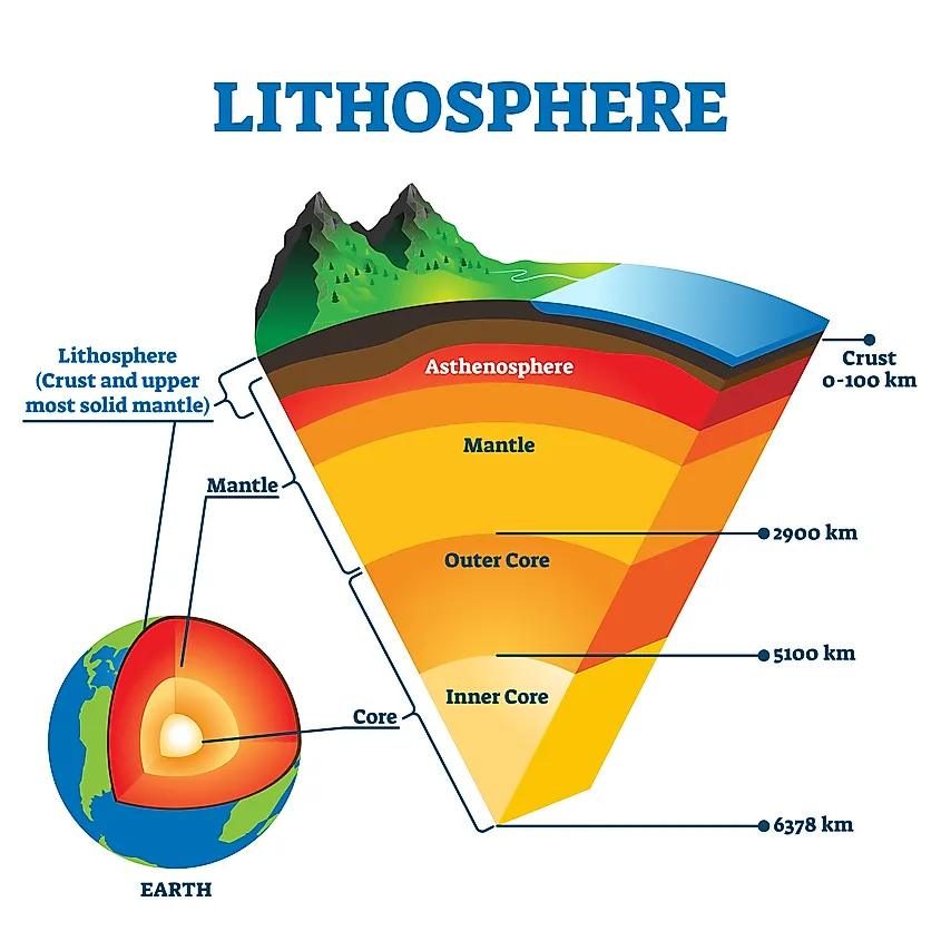
How is the lithosphere defined?
The rigid outermost part/ shell of the Earth, consisting of the crust and upper mantle.
What is a volcano?
A vent or opening in the Earth’s crust through which lava, rock fragments, gases, and ash are ejected.
What is an archipelago?
A chain or group of islands clustered together in a sea or ocean.
What is the geological definition of the Caribbean?
The area defined by the Caribbean Plate that shares similar seismic, tectonic, and volcanic features.
Under the geological definition, which territories are considered Caribbean?
Only islands and territories that lie on the Caribbean Plate.
Which territories that are widely accepted as Caribbean are excluded under a strictly geological definition?
The Bahamas, Guyana, Cuba, and Trinidad, because they do not lie on the Caribbean Plate.
What is an anomaly or shortcoming regarding the public's understanding of the geological definition?
The average individual does not understand the concept of plate tectonics and may not be able to identify with this definition.
Which recent volcanic eruptions occurred in the eastern Caribbean from north to south?
Soufriere Hills, Montserrat (1995-1998); Soufriere, Guadalupe (1976-1977); Mount Pelee, Martinique (1902, 1929); Soufriere, St. Vincent (1902, 1971-1979); and Kick-em Jenny, Grenada (submarine).
What is the geographical definition of the Caribbean?
The area washed by the Caribbean Sea.
Which island groups are included under the geographical definition of the Caribbean?
The Greater Antilles, Lesser Antilles, the Cayman Islands, and the islands of the Netherland Antilles.
Which mainland countries are included under the geographical definition because they are washed by the Caribbean Sea?
Belize, Colombia, Venezuela, Costa Rico, Panama, Nicaragua, and Honduras.
Which traditional Caribbean islands are excluded under the strict geographical definition?
Barbados and the Bahamas, because they lie in the Atlantic Ocean rather than the Caribbean Sea.
Why are mainland territories such as Suriname, Guyana, and French Guiana excluded under the geographical definition?
Because they are not located in the Caribbean Sea (even though they share historical and demographic features with the Caribbean).
What is the advantage of the geographical definition of the Caribbean?
It allows the general region known as the Caribbean to be easily located on a map of the world as it links the Caribbean areas with the Caribbean Sea.
Which islands are the southernmost Caribbean islands?
Trinidad and Tobago.
What is unique about Barbados regarding its geographic location and Caribbean status?
It is the most eastern Caribbean island and is located in the Atlantic Ocean, but it is considered Caribbean because of its shared culture and history.
Why are Belize, Guyana, Suriname, and French Guiana accepted as part of the Caribbean despite their mainland locations?
Belize is in Central America and Guyana, Suriname, and French Guiana are in South America, but they are accepted because they share similar history and politics with other Caribbean territories.
What is the Yucatan Channel?
A strait between Mexico and Cuba that connects the Caribbean Sea with the Gulf of Mexico.
Which passage connects the Caribbean Sea and the Atlantic Ocean between Cuba and Hispaniola?
The Windward Passage.
Where is the Dominica Channel located and what does it separate?
It is located in the Lesser Antilles and flows between Dominica and Martinique, connecting the Caribbean Sea and the Atlantic Ocean.
What bodies of land and water are separated or connected by the Anegada Passage?
It connects the Caribbean Sea and the Atlantic Ocean and separates the British Virgin Islands from the Leeward Islands.