Limnology Exam 1
 Call Kai
 Learn
Learn Practice Test
 Spaced Repetition
 Match
Match Flashcards
 Knowt Play
1/88

Earn XP
Description and Tags
Mainly definitions
Name | Mastery | Learn | Test | Matching | Spaced | Call with Kai | Chat |
|---|
No analytics yet
Send a link to your students to track their progress
89 Terms
Lentic
standing waters
Lotic
flowing waters
Francois Forel “father of limnology”
1901 - first text on limnology
Noel Hynes
1970 - first text on lotic ecosystems
Mitsch and Gosseling
1985 - first text on wetlands
G. Evelyn Hutchinson
Treatise on limnology published
Developed lake classification
Molecular structure of water
Covalent bonds
Hydrogen bonds (104 degrees apart)
Tetrahedral arrangement of water molecules
Density-temp relationship
density decreases as temperature increases
Viscosity
A measure of liquids resistance to flow (how difficult it is to move through something)
temp-density-viscosity relations
temp increases as density and viscosity decrease - reason below
temp decreases as density and viscosity increase
why? because as the water temp increases the molecules are more spread apart
Specific heat of water
The amount of heat required to raise or lower the temp of a substance by 1 degree Celsius.
Surface tension
The measure of the strength of the waters surface film.
reduced strength with increased temps and dissolved organic compounds.
closed basin
endoheic lakes - no outflow, loses water through evaporation
Open basin
exorheic lakes - water flows out of the basin
Glacial
75% of lakes are from glacial origin.
types of glacier lakes -
kettle lakes
ice scour lakes
cirque lakes
paternoster lakes
Tectonic
formed as a result of the movement/uplift of the earths crust - faulting
old and deep
less productive due to great depths
Volcanic
Ejected volcanic material leaves empty chambers (caldera)
Released lava creates depressions and cavities
relatively unproductive lakes
very little human influence
Coastal
relatively young
formed by water currents depositing large amounts of sediment along a bay
generally blackish water
can be connected right by a ocean
usually higher salt concentration
Riverine (fluvial)
generally small in size and number
contains -
oxbow lakes-cutoff river bends
blocked valley lakes-formed when the main river deposits sediment that blocks the tributary
floodplain or levee lakes-formed when rivers overflow their banks
Landslides
Large movements of earthen material into stream valleys, can dam rivers.
usually from earthquake activity
extremely unstable
can create or make lakes go away
Sinkholes
Solution (karst) lakes- found in basins of highly soluble rock(limestone)
slightly acidic waters
found in limestone regions of the world
man made (reservoirs)
more than 60,000 large reservoirs
hold 14% of global annual runoff
more than a million small reservoirs
*every reservoir has a dam
Littoral zone
near shore region influenced by the wave action and spray
Pelagic/limnetic zone
the open water beyond the littoral zone
Benthic zone
lake bottom
Photic zone (more o2)
upper sunlit waters where photosynthesis occurs
*greater than 1% of light
Aphotic zone (less o2) (profundal zone)
lower layer of water with less than 1% of light
Compensation depth
when photosynthesis meets the rate of respiration
Light meter
Underwater photo cell that measures the vertical extinction of light
Secchi disk
measure of transparency, super important can tell you a lot of information on a lake
*times 2 secchi disk measurement for compensation depth
Epilimnion
Surface, mixed layer
Metalimnion
transition layer, characterized by a rapid decline in temp with depth (thermocline)
Hypolimnion
deep cooler layers of lake below the metalimnion, reduced turbulence and light
Ultraviolet range
100-400nm
visible radiation range
400-700nm
infrared range * long wavelengths
700-3000nm
Solar energy
continuous flow of electromagnetic waves, discrete pulses of energy called quanta or photons
if you have a high reflection on the water surface you have
less light getting in the lake
if you have a low reflection on the water surface you have
more light getting in the lake
Reflection
average loss of reflection is 5-6% on a clear summer day
Scattering
deflection of photons by molecules and particles *shorter wavelengths scatter faster
Transmission
light that passes through the water column
Light irradiance
measure of the number of photons passing through a unit area.
Light attenuation
rapid reduction in light irradiance with depth due to scattering and absorption of solar energy.
Light equation
Iz=Io e^-kz
Iz- irradiance at depth z
Io- irradiance at the surface of the lake
k-vertical extinction coefficient
Equation to solve for kd
kd=(lnIo-lnIz) / z
kd tells you the light structure in a lake, if you have a higher extinction coefficient you have less light getting through the lake.
Eutrophic (lack o2)
nutrient rich (algae)
Oligotrophic (more o2)
Nutrient poor (higher water quality systems)
Watershed
the area of land that drains towards an aquatic ecosystem
unconstrained low gradient
not a lot holding in place
constrained high gradient
keeping it packed in. (ex. elevation changes make this happen)
Stratification
wind induced currents are unable to mix the layers, lake divides into 3 different layers; epilimnion, metalimnion, and hypolimnion
Stability
Likelihood that a stratified lake will stay stratified
Turnover
same density throughout lake, no more zones.
mixing of entire water column
Fetch
length of unobstructed area; lakes that are bigger and have no objects (islands) in the way will have a greater fetch.
Amictic
never mix because lake is frozen
Holomictic
lake mix completely (top to bottom)
Meromictic
never fully mix
types of holomictic lakes
monomictic lakes - 1 period mixing
cold and warm
Dimicitic lakes - 2 periods mixing and 2 periods stratification
summer and winter = strat; fall and spring = overturn
Polymictic lakes - mix many times a year
Isothermal
Same temperature top to bottom
Cold monomictic lakes
1 period of mixing, frozen all winter, mix briefly at cold temps in summer
overturn during summer
Warm monomictic lakes
1 period of mixing, stratification in summer. does not freeze and mixes all winter
Cold polymictic lakes
mix many times a year, ice covered all winter, may stratify for brief periods during the summer, but it can be interrupted.
Warm polymictic lakes
mix many times a year, never ice over, may stratify for days or weeks at a time.
Meromictic
lakes that never mix and become chemically stratified.
Chemocline
boundary between the mixolimnion and the monimolimnion, below the thermocline *high salinity underneath the boundary
Monimolimnion
does not mix with the upper water, results from accumulation of salts, and high salinity
Biogenic meromixis * have to have a hypolimnion for this to happen
An input of salts due to biological activity (decomposition)
2 main ways this can happen
great depth
sheltered lakes with relatively small surface area relative to depth
Ectogenic meromixis * have to have a hypolimnion for this to happen
An external events brings salts into a freshwater lake. Saltwater accumulates at the bottom. Can be human influenced
Crenogenic meromixis * have to have a hypolimnion for this to happen
Gases or high salinity groundwater introduced to deep portions of the lake from chemical processes in the earths crust.
*eruptions can happen because of trapped co2
Coriolis force
force that causes moving objects; such as wind, water, or projectiles to curve as a result of the earths rotation.
Wave height
difference between crest and trough
*can be calculated by fetch
Hmax=0.332*F^0.5
Wave length
difference between two crests
Breaker
Occurs because wavelength decreases and height increases near shore. So we have a bigger waves near shore.
Seiches - to dry
refers to periodictic drying exposures of shallow littoral zones.
most often caused by wind induced tilting of the water.
Surface seiche
high level of water goes to one end due to wind. *goes above the still water line. This happens from constant wind blowing from one direction.
Internal seiche
Occurs at the thermocline when a lake is stratified. Detected by the rise and fall of the thermocline. Also tilts the water line. Erodes the thermocline.
Entrainment
mixing of layers for a brief period of time
Currents
no periodicity, forward movement *gradual movement of water
Langmuir circulation
winds can develop a series of vertical helical currents at the surface.
foam streaks form from winds going in one direction. low density in streaks. *lakes have to be big enough for this to happen
Ekman spiral
Deflects surface currents, goes to the right of wind direction. Angle of deflection + water speed declines with depth, the deepest current flows in the opposite direction to wind.
Density induced current
Differential heating throughout the lake creates density currents. Bays and littoral zones heat and cool more rapidly than pelagic areas.
Types -
underflow - colder dense water coming in *flows to the bottom
overflow - warmer water coming in, less dense *stays to the surface
interflow - water is median “middle”
Longshore currents
current flowing parallel to shoreline between the breaker waves and shore. If waves approach at a angle to shoreline from the right, current will be to the left. *this is important in eroding and redepositing sediment
Rip currents
Narrow, fast currents moving offshore. Occur when a longshore current meets a physical barrier and is deflected out.
What I learned from Dr. Bo’s presentation
The current in rivers and stream will push spilled oil downstream
Wind has a lot of affect during oil spills causing it to drift into our riparian zones which can cause a lot of issues.
The sunken oil can smother our benthic bottoms which suffocate macro invertebrates, and destroy spawning grounds.
Research projects happening at CFRE
Oil particle interactions
Monitoring and detection of oil
Biological impacts of oil (MPRI BIO)
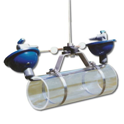
VanDorn Sampler
A specialized device used by scientists to collect discrete water samples from a specific depth in lakes, rivers, streams, or the ocean.
Stephen Forbes (1887)
Lakes as super - organisms
Lakes as microcosm
Birge and Juday (1900s)
Wisconsin lakes; UW Madison Comparative limnological surveys