Instrument
 Call Kai
 Learn
 Practice Test
 Spaced Repetition
 Match
 Flashcards
 Knowt Play
1/165

There's no tags or description
Looks like no tags are added yet.
166 Terms

During the ILS RWY 13 procedure at DSM, the minimum altitude for glide slope interception is
2,600 feet MSL.

If an aircraft was cleared for the ILS RWY 18 at Lincoln Municipal and crossed the Lincoln VORTAC at 5,000 feet MSL, at what point in the teardrop could a descent to 3,200 feet commence?
Immediately.
Which fixes on the IAP Charts are initial approach fixes?
Any fix that is identified by the letters IAF.
What does the symbol T within a black triangle in the minimums section of the IAP for a particular airport indicate?
Takeoff minimums are not standard and/or departure procedures are published.

A pilot plans to fly to Baldwin for Christmas. What minimum equipment is required for the VOR/DME or GPS-A procedure, and can the pilot complete the flight?
One VOR receiver and one DME receiver; no flight though, the airport is closed.
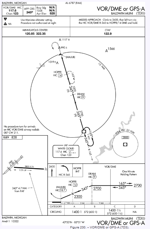
The minimum safe altitude (MSA) for the VOR/DME or GPS-A at 7D3 is geographically centered on what position?
WHITE CLOUD VOR/DME.
On a nonprecision approach, what is the maximum acceptable descent rate during the final stages of the approach (below 1,000 ft. AGL)?
1,000 fpm.

What is the minimum altitude descent procedure if cleared for the S-ILS 9 approach from Seal Beach VORTAC?
Descend and maintain 3,000 to JASER INT, descend to 2,500 while established on the LOC course inbound, intercept and maintain the GS to 960 (DA).

Refer to the APA (Centennial) ILS RWY 35R procedure. The PFAF (Precision Final Approach Fix) intercept altitude is
8,000 feet MSL.

ATC assigns the RAL Runway 9 ILS. In the event that a missed approach is necessary, the pilot determines they will climb with 120 knots ground speed. What would the missed approach rate of climb be?
540 feet per minute minimum.

At which location or condition does the STELA.STELA1 arrival begin?
CANAN intersection
How can the pilot determine, for an ILS runway equipped with MALSR, that there may be a penetration of the obstacle identification surfaces (OIS), and care should be taken in the visual segment to avoid any obstacles?
The published visibility for the ILS is no lower than 3/4 SM.
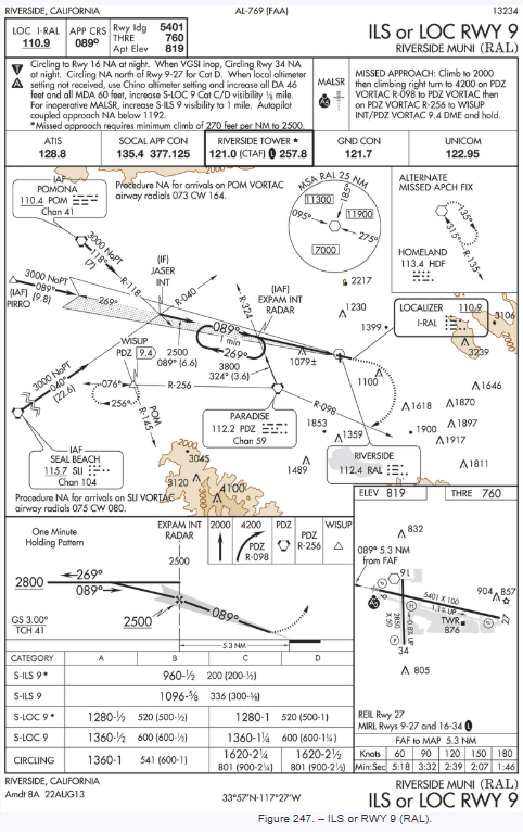
How should a pilot reverse course to get established on the in bound course of the ILS RWY 9, if radar vectoring to EXPAM?
Make an appropriate entry to the depicted holding pattern at EXPAM INT.

A pilot has been cleared for the RNAV (GPS) RWY 36 approach to LIT. At a groundspeed of 105 knots, what are the vertical descent angle and rate of descent on final approach?
3.00 degrees and 557 feet per minute.
Which of the following statements regarding STARs (Standard Terminal Arrivals) is most accurate?
STARs facilitate the transition between the en route portion of the flight and the instrument approach procedure.

How should the missed approach point be identified when executing the RNAV (GPS) RWY 36 approach at Adams Field?
When the TO-FROM indicator changes.

The symbol on the plan view of the ILS or LOC RWY 13 procedure at DSM represents a minimum safe sector altitude within 25 NM of
Des Moines VORTAC.
Which procedure should be followed by a pilot who is circling to land in a Category B airplane, but is maintaining a speed 5 knots faster than the maximum specified for that category?
Use the approach minimums appropriate for Category C.
Under the stabilized approach concept, what is the maximum acceptable descent rate during the final stages of an approach?
1,000 fpm for either precision or nonprecision approaches.

At which point does the JEN.JEN9 arrival begin?
GLEN ROSE VORTAC

During the approach to DSM before beginning the ILS RWY 13 procedure, the glide slope fails and the pilot is cleared for the LOC RWY 13 at DSM. What altitude minimum applies?
1,380 feet

When using the hold for course reversal for the RNAV (GPS) RWY 36, at what point will the pilot turn inbound for the approach?
4 DME miles from FEHXE.

During the ILS RWY 13 procedure at DSM, what altitude minimum applies if the glide slope becomes inoperative?
1,380 feet

What minimum airborne equipment is required to be operative for RNAV (GPS) RWY 36 approach at Adams Field?
Any approved RNAV receiver
When the approach procedure involves a procedure turn, the maximum speed should not be greater than
200 knots IAS

At what minimum altitude should a pilot cross RAMKE intersection during the S-LDA RWY 6 approach at ROA?
4,300 MSL
While being radar vectored, an approach clearance is received. The last assigned altitude should be maintained until
established on a segment of a published route or IAP.

What type of entry is recommended to the missed approach holding pattern if the inbound heading is 050°?
Teardrop
How can an initial approach fix be identified on a Standard Instrument Approach Procedure (SIAP) Chart?
All fixes that are labeled “IAF” which are depicted on the plan view.
What action is recommended if a pilot does not wish to use an instrument departure procedure?
Enter “No DP” in the REMARKS section of the IFR flight plan.
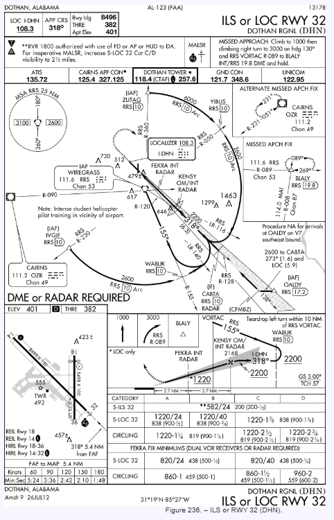
What landing minimums apply for a 14 CFR Part 91 operator at Dothan, AL using a category C aircraft during a circling LOC 32 approach at 120 knots? (Dual VORs available.)
MDA 860 feet MSL and visibility 1 and 1/2 SM.
Which is true regarding the use of an instrument departure procedure chart?
To use an instrument departure procedure, the pilot must possess at least the textual description of the approved procedure.
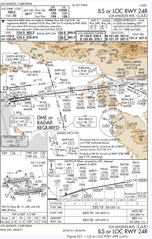
The final approach fix for the ILS RWY 24R is located at
Glide Slope Intercept (lightning bolt).

What options are available concerning the teardrop course reversal for LOC RWY 18 approach to Lincoln?
If a course reversal is required, only the teardrop can be executed.
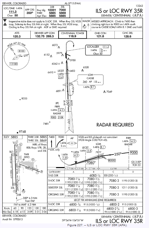
What is the minimum safe altitude (MSA) when maneuvering northeast of APA?
8,100 feet

When the MALSR are NOTAM’d out of service, what are the minimums for a category B airplane LPV approach?
4500 RVR
The primary reason single pilot operations in reduced visibility on an instrument approach procedure are made more difficult than multicrew operations is that the pilot must
continue to fly by instruments while attempting to acquire a visual reference for the runway.
Which clearance procedures may be issued by ATC without prior pilot request?
DP’s, STAR’s, and visual approaches.
Unless otherwise stated, instrument procedures use the standard IFR climb gradient of
200 feet per nautical mile.
When being radar vectored for an ILS approach, at what point may the pilot start a descent from the last assigned altitude to a lower minimum altitude if cleared for the approach?
When established on a segment of a published route or IAP.
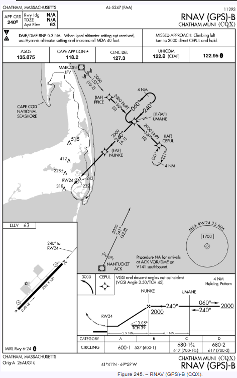
What is the recommended holding pattern entry if a pilot is executing the missed approach at CQX from the RNAV (GPS)-B approach?
Direct
During an instrument precision approach, terrain and obstacle clearance depends on adherence to
minimum altitude shown on the IAP.

At which points may a pilot initiate a descent to the next lower minimum altitude when cleared for the VOR/DME RWY 36 approach, from the PUC R-095 IAF (DME operative)?
Start descent from 8,900 when established on the PUC R-189, from 8,000 at the 8.3 DME fix, from 7,500 at the 5.1 DME fix, and from 6,240 when landing requirements are met.

A pilot is executing the Centennial Airport (APA) ILS RWY 35R approach. What is the crossing altitude at the outer marker?
7,977 feet MSL
Which is true regarding STARs?
STARs are established to simplify clearance delivery procedures.

What indication should a pilot get when it is time to turn in bound while in the procedure turn at FEHXE?
4 DME miles from FEHXE.
The instrument approach criteria for a Category A aircraft is based on a maximum airspeed of
90 knots
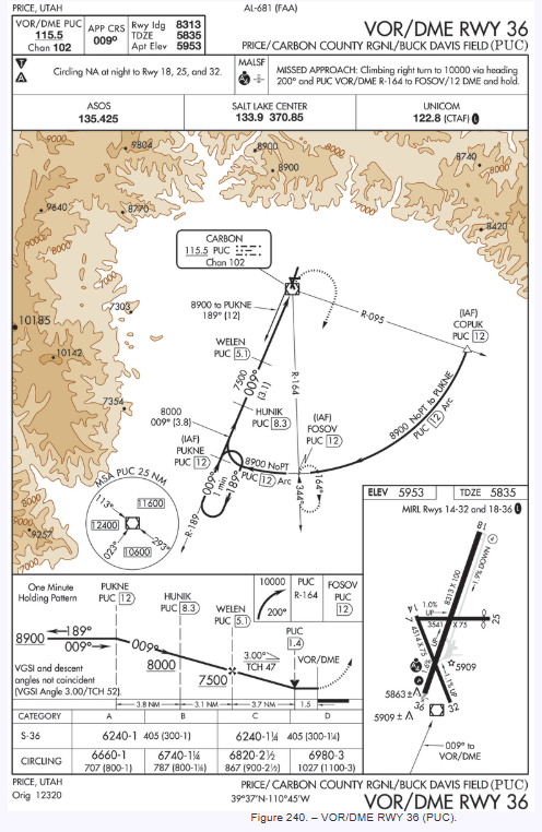
If the DME at PUC airport is inoperative, the airborne DME will
not transmit a coded identification audio tone.

What minimum navigation equipment is required to complete the VOR/DME-A procedure?
One VOR receiver and DME.

The missed approach point for the LOC RWY 31 procedure is
2:33 from PECAT.

What is the recommended descent angle for the RNAV (GPS) RWY 36 approach?
3.00°.
When may a pilot make a straight-in landing, if using an IAP having only circling minimums?
A straight-in landing may be made if the pilot has the runway in sight in sufficient time to make a normal approach for landing, and has been cleared to land.
What obstacle clearance and navigation signal coverage is a pilot assured with the Minimum Sector Altitudes depicted on the IAP charts?
1,000 feet within a 25 NM radius of the navigation facility but not acceptable navigation signal coverage.
When simultaneous approaches are in progress, how does each pilot receive radar advisories?
On tower frequency
A particular instrument departure procedure requires a minimum climb rate of 210 feet per NM to 8,000 feet. If the aircraft climbs with a ground speed of 140 knots, what is the rate of climb required in feet per minute?
490
Aircraft approach categories are based on
1.3 times the stall speed in landing configuration at maximum gross landing weight.
ATC can issue a STAR (Standard Terminal Arrival)
when ATC deems it appropriate, unless the pilot requests “No STAR.”
During an instrument approach, under what conditions, if any, is the holding pattern course reversal not required?
When radar vectors are provided.
An airport may not be qualified for alternate use if
the NAVAIDs used for the final approach are unmonitored.
When making an instrument approach at the selected alternate airport, what landing minimums apply?
The landing minimums published for the type of procedure selected.

For takeoff on RWY 9 using an average groundspeed of 140 knots, what minimum rate of climb would meet the required minimum rate of climb as specified on the instrument departure procedure?
970 feet per minute

If cleared for an S-LOC 18 approach at Lincoln Municipal from over HUSKR, it means the flight should
begin final approach without making a procedure turn.
If the plan view on an approach chart does not include a procedure turn barb, that means
a procedure turn is not authorized.

What is the purpose of the 10,600 MSA on the Price/Carbon County Airport Approach Chart?
It provides safe clearance above the highest obstacle in the defined sector out to 25 NM.
While flying a 3° glide slope, a headwind shears to a tailwind. Which conditions should the pilot expect on the glide slope?
Airspeed and pitch attitude decrease and there is a tendency to go below glide slope.
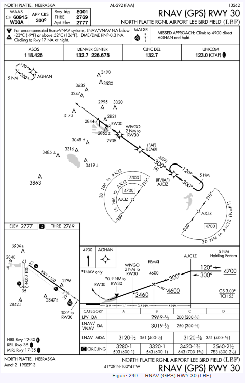
At what point would a pilot execute the missed approach for the LNAV approach at LBF?
RW 30 waypoint for the LNAV.

A pilot has been cleared for the Straight-in Localizer approach for runway 13L at DAL. Prior to reaching the final approach fix, ATC advises that the RVR is not available and that the visibility is 1/2 SM. The pilot may
convert the RVR to statute miles and continue the approach.

When conducting a missed approach from the RNAV (GPS) X RWY 28L approach at PDX, what is the Minimum Safe Altitude (MSA) while maneuvering?
5,800 feet MSL
The rate of descent on the glide slope depends on
ground speed
When passing through an abrupt wind shear which involves a shift from a tailwind to a headwind, what power management would normally be required to maintain a constant indicated airspeed and ILS glide slope?
Lower than normal power initially, followed by a further decrease as the wind shear is encountered, then an increase.
When cleared to execute a published sidestep maneuver for a specific approach and landing on the parallel runway, at what point is the pilot expected to commence this maneuver?
As soon as possible after the runway or runway environment is in sight.
When may a pilot obtain a contact approach?
ATC will assign a contact approach only upon request if the reported visibility is at least 1 mile.
When is radar service terminated during a visual approach?
Automatically when ATC instructs the pilot to contact the tower.
What effect will a change in wind direction have upon maintaining a 3° glide slope at a constant true airspeed?
When ground speed increases, rate of descent must increase.

For a stabilized approach, the aircraft must be in an approved configuration for landing
with the correct speed and on glide path before descending below 1,268 feet MSL.
A Precision Runway Monitor (PRM) approach requires
simultaneously monitoring two frequencies.

If the RVR is not reported, what meteorological value should the pilot substitute for 2400 RVR?
A ground visibility of 1/2 SM.

The missed approach point for the DUC RNAV (GPS) RWY 17 (LNAV/VNAV) procedure is
1,903 feet MSL.
The glide slope and localizer are centered, but the airspeed is too fast. Which should be adjusted initially?
Power only
What are the main differences between a visual approach and a contact approach?
The pilot must request a contact approach; the pilot may be assigned a visual approach and higher weather minimums must exist.
The rate of descent required to stay on the ILS glide slope
must be decreased if the ground speed is decreased.
RVR minimums for landing are prescribed in an IAP, but RVR is inoperative and cannot be reported for the intended runway at the time. Which of the following would be an operational consideration?
RVR minimums which are specified in the procedures should be converted and applied as ground visibility.
Precision Runway Monitoring (PRM) is
a RADAR system for monitoring approaches to closely spaced parallel runways.
If an early missed approach is initiated before reaching the MAP, the following procedure should be used unless otherwise cleared by ATC.
Proceed to the missed approach point at or above the MDA or DH before executing a turning maneuver.

If the RVR equipment is inoperative for an IAP that requires a visibility of 2,400 RVR, how should the pilot expect the visibility requirement to be reported in lieu of the published RVR?
As a ground visibility of 1/2 SM.
What are the main differences between the SDF and the localizer of an ILS?
The SDF course may not be aligned with the runway and the course may be wider.
A pilot arrives at the destination airport on an IFR flight plan. Which is a prerequisite condition for the performance of a contact approach?
Clear of clouds and at least 1 SM flight visibility.
Assume this clearance is received:
“CLEARED FOR ILS RUNWAY 07 LEFT APPROACH, SIDE-STEP TO RUNWAY 07 RIGHT.”
When would the pilot be expected to commence the side-step maneuver?
As soon as possible after the runway environment is in sight.
A contact approach is an approach procedure that may be used
in lieu of conducting a SIAP.
If the pilot loses visual reference while circling to land from an instrument approach and ATC radar service is not available, the missed approach action should be to
make a climbing turn toward the landing runway and continue the turn until established on the missed approach course.
While flying a 3° glide slope, a constant tailwind shears to a calm wind. Which conditions should the pilot expect?
Airspeed and pitch attitude increase and there is a tendency to go above glide slope.
While being vectored, if crossing the ILS final approach course becomes imminent and an approach clearance has not been issued, what action should be taken by the pilot?
Maintain the last assigned heading and query ATC.
Thrust is managed to maintain IAS, and glide slope is being flown. What characteristics should be observed when a headwind shears to be a constant tailwind?
PITCH ATTITUDE: Decreases; REQUIRED THRUST: Increased, then reduced; VERTICAL SPEED: Increases; IAS: Decreases, then increases to approach speed.
How wide is an SDF course?
Either 6° or 12°.
What does the Runway Visual Range (RVR) value, depicted on certain straight-in IAP Charts, represent?
The horizontal distance a pilot should see when looking down the runway from a moving aircraft.
During a precision radar or ILS approach, the rate of descent required to remain on the glide slope will
increase as the groundspeed increases.
Flying clear of clouds on an instrument flight plan, what are the requirements for a contact approach to an airport that has an approved IAP?
The pilot must request the approach, have at least 1 mile visibility, and be reasonably sure of remaining clear of clouds.
The controller must determine that the pilot can see the airport at the altitude flown and can remain clear of clouds.
The controller must have determined that the visibility was at least 1 mile and be reasonably sure the pilot can remain clear of clouds.
When tracking in bound on the localizer, which of the following is the proper procedure regarding drift corrections?
Drift corrections should be accurately established before reaching the outer marker and completion of the approach should be accomplished with heading corrections no greater than 2°.