Remote Sensing Unit 1
 Call Kai
 Learn
Learn Practice Test
 Spaced Repetition
 Match
Match Flashcards
 Knowt Play
1/54

There's no tags or description
Looks like no tags are added yet.
Name | Mastery | Learn | Test | Matching | Spaced | Call with Kai | Chat |
|---|
No analytics yet
Send a link to your students to track their progress
55 Terms
active remote sensing
an electromagnetic ray is emitted, then reflected back to a sensor and recorded
LiDAR
a form of active remote sensing; laser emitter and sensor units are attached to aircraft, which aims lasers at the ground and records the time it takes for the laser to bounce back to convert to point clouds
point cloud
a discrete set of data points in space which may represent a 3D shape or object
ground penetrating radar (GPR)
a form of active sensing; consists of a transmitter, a receiver, and antennae that are used to see below ground without excavating pits
passive remote sensing
sensing that uses the sun’s energy reflecting off the earth to a sensor
satellite digital imagery
a form of passive sensing; landsat and other satellites take images of the Earth’s surface using measurements of actual reflectance values, including both visible and non-visible bands of the EM spectrum
pixel
the smallest area that makes up a component of a digital image; larger pixels = less refined detail = larger area
resolution
the amount of information available in a satellite imagery; higher resolution = smaller pixel = finer detail
multispectral remote sensing
sensing based on the principal that energy from the sun is broken up into multiple components (ie colors/light spectrum); collect data in multiple spectral bands (4-30ish)
wavelength
the distance between successive crests of the wave, typ. in m, cm, mm, etc
frequency
the number oc oscillations completed per second measured in hertz (Hz)
gamma rays
>ten-trillionths of a meter wavelength w/ extreme penetrating capabilities generated by radioactive atoms
x-ray
10-billionths of a meter to 10-trillionths of a meter wavelength w/ great penetrating power and extensive medical applications
ultraviolet rays
wvl of 400-billionth to 10-billions of a meter that can burn skin and are largely blocked by the ozone layer
visible rays
400-700 nm wavelength, best for identifying objects by visible colors
infrared rays
wavelengths extend from visible range to 1mm, including thermal radiation, with applications in locating thermal pollution and crop health
microwave radiation
range from 1mm to 30cm used for heating food and radar weather applications
radio waves
range from >1 cm to tens or hundreds of meters, used to transmit radio signals and create images through darkness or clouds
spectral irradiance
the radiant flux received by a surface per unit area per unit of frequency or wavelength
spectral irradiance
come back
transmission
the movement of light through a material; length dependent
reflection
the process of radiation bouncing off an object; angle at which radiation hits and obect = radiation is reflected at the same angle
absorption
EM energy is absorbed and converted int another form of energy; tends to occur in absorption bands
scattering
the unpredictable reflection of radiation by atmospheric particles; largely occurs high in the atmosphere
refraction
the bending of light when it passes from one medium to another; dependent on angle with vertical, distance through mediums, and air density
diffuse reflection
combined diffuse and partial specular possible depending on the surface
apparent optical property (AOPs)
a property that can be explained as a function of two inherent optical property (e.g. reflectance (R = scattering/(absorption+scattering)))
inherent optical properties (IOPs)
cannot be explained as a function of other properties (e.g. absorption and scattering)
ground-based platform
hand-held of mounted on tripods, towers, etc
airborne platforms
most airplanes with camera or digital sensors attached
RGB
3-band systems
RGBN
traditional Landsat bands
superspectral
covers the entire spectral range
hyperspectral
covers many bands (typ. over 100)
stereogram
two of more overlapping sets of air photos properly positioned for viewing with a stereoscope
aerial photo striping
occurs from sensor malfunction, calibration errors , or instrument design
aerial photo saturation
too much light reaches the detector as a result of a long integration time or shutter aperture that is too wide
scan line correctors (SLC’s)
a mechanism placed behind the primary optics designed to compensate for the forward motion that creates a zigzag pattern while sideways scanning, stitching together a rectilinear image
spatial resolution
distance between independent measurements, or the physical dimension that represents a pixel of the image
temporal resolution
the amount of time it takes a satellite to revisit a particular location on the Earth’s surface; related to orbit pattern, swath width, speed of satellite, and orbital overlap; higher = imaged more frequently
Instantaneous Field-Of-View (IFOV)
the area on the Earth’s surface recorded by a single sensor element at any moment in time; size sets the pixel width
Ground Sample Distance (GSD)
distance on ground determining one dimension of a pixel, which is affected by flight speed; shoudl be set to match the IFOV
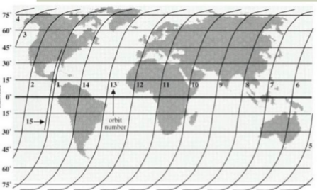
low-Earth orbit satellites
orbit roughly pole to pole while the Earth spins underneath, continually scanning a thin ribbon of data
geostationary satellites
in sync with the orbit of the Earth and can look at the same spot so long as they remain in orbit
metadata
information about the data itself; Landsat metadata typ includes date taken, GPS coordinates, path/row, name of sensor, cloudiness level, and other facts about the digital image
objective image interpretation
a type of interpretation that usually involves numbers
subjective image interpretation
interpretation involving elements of recognition, including knowledge of subject matter
site
the location of an object in relation to its environment
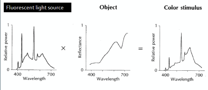
color stimulus calculation
light source x Object Diffuse Spectral Reflectance = color stimulus (aka spectral power distribution)
CIE 1979 Color Gamut
provides a definition of human color vision based on the tristimulus response function of the human eye
bit depth
how many levels a pixel can hold
histogram equalization
spread the range of brightness values but preserves the peaks and valleys in the histogram, allowing for higher contrast
primary color theory
remote sensing is energy we cannot see being reflected and recorded; to represent that energy, we must use colors we can see
additive primary theory
based on the wavelengths of light and on the assumption that we always start with black then add the primary colors of RBG to make all other colors; to create white, all light is reflected back to the eye
subtractive color theory (aka CYMK model)
based on the light absorbing quality of ink printed onto paper; white light strikes the inks, is partially absorbed and partially reflected; a perfect mix of cyan, magenta, and yellow absorbs all light resulting in black