Unit Three: Plants as Drinks and Drugs
 Call Kai
 Learn
 Practice Test
 Spaced Repetition
 Match
 Flashcards
 Knowt Play
1/85

There's no tags or description
Looks like no tags are added yet.
86 Terms
Hydrologic cycle
The continuous movement of water between the atmosphere, Earth's surface, and the subsurface through evaporation, transpiration, condensation, precipitation, infiltration, runoff, and groundwater flow.
Three possible fates of precipitated water
-Infiltration
-surface runoff
-evapotranspiration
Drainage basin
An area of land where all water drains toward a common outlet, such as a stream, river, or lake.
Drainage divide
A ridge or area of higher elevation that separates neighboring drainage basins.
What drives groundwater flow?
Gravity and differences in hydraulic head (the elevation and pressure of groundwater) drive groundwater from areas of higher hydraulic head to areas of lower hydraulic head.
How is groundwater flow calculated?
Darcy's law, Q = KIA, where Q is discharge, K is hydraulic conductivity, I is the hydraulic gradient (change in hydraulic head divided by distance), and A is the cross-sectional area through which water flows.
How is aquifer discharge measured in practice?
By measuring the volume of water pumped from a well per unit of time or by measuring groundwater flow through a known cross-sectional area.
How is stream discharge calculated?
Discharge equals the average stream velocity multiplied by the stream's cross-sectional area (Q = VA).
Flood frequency and probability
Flood frequency describes how often a flood of a particular magnitude is expected to occur. The annual exceedance probability is the probability that a flood of that magnitude or greater will occur in any given year.
P = 1 / T
Probability
How do you determine whether a flood is a hundred-year flood?
100-year flood has a 1% chance of being equaled or exceeded in any given year.
1/100
Does a hundred-year flood occur exactly once every 100 years?
No. It has a 1% annual probability and can occur more than once in a century or in consecutive years.
Downslope force (Fd or Fp)
The component of gravitational force acting parallel to a slope and pulling material downhill.
Frictional force (Ff)
The resisting force between materials that opposes downslope movement.
Stable slope
A slope where frictional resistance exceeds the downslope driving force (Ff > Fd).
Metastable slope
A slope where frictional resistance and the downslope driving force are approximately balanced, leaving the slope close to failure.
Slope failure
Occurs when the downslope driving force exceeds frictional resistance (Fd > Ff), causing material to move downhill.
Why is an ideal longitudinal stream profile concave?
A stream generally becomes less steep downstream as discharge increases and the channel becomes more efficient at transporting sediment. The upper course needs a steeper gradient to transport material, while the lower course can transport material at a gentler gradient.
Channel aspires to correct to a change in base level
Aggradation
The raising of a streambed or longitudinal profile due to sediment deposition, often caused by increased sediment supply, decreased stream discharge or transport capacity, or a reduction in channel slope.
Causes of aggradation
Increased sediment input from landslides or erosion, reduced water flow, dams or other obstructions that trap sediment, and changes in base level that encourage deposition.
Incision
The lowering of a streambed or longitudinal profile as a stream erodes and removes material from its channel.
Causes of incision
Increased stream discharge or erosive power, decreased sediment supply, a drop in base level, tectonic uplift, and an increase in channel gradient.
How can frictional force (Ff) decrease and cause slope failure?
Water saturation can increase pore-water pressure and reduce effective stress; weathering can weaken rock; undercutting can remove support; earthquakes can disturb slope material; and vegetation removal can reduce root reinforcement.
Primary way to increase downslope force (Fd)
Increase the slope angle, which increases the component of gravitational force acting parallel to the slope.
Why are water and climate important in slope stability?
Rainfall can saturate soil, increase pore-water pressure, add weight, and reduce frictional resistance. Freeze-thaw cycles and chemical weathering can weaken rock. Drought can also contribute to vegetation loss and soil degradation.
Slope angle and slope stability
Steeper slopes have a larger downslope gravitational force, making failure more likely when resistance is insufficient.
Vegetation and slope stability
Plant roots bind soil and reinforce slopes, while vegetation intercepts rainfall and reduces erosion. Removing vegetation can increase runoff, erosion, and the likelihood of slope failure.
Geology and slope stability
Rock type, bedding, fractures, faults, and the orientation of rock layers influence the strength of a slope. Weak, fractured, or unfavorably layered materials are generally more susceptible to failure.
Weathering and slope stability
Physical and chemical weathering break down or weaken rock, reduce material strength, and can make slopes more susceptible to landslides.
Fall
A mass of rock or soil detaches from a steep slope or cliff and moves primarily through free fall, bouncing, or rolling.
Slide
A mass of rock or soil moves downslope along a relatively distinct failure surface.
Slump
A type of slide in which material moves along a curved failure surface, commonly rotating backward as it moves downhill.
Flow
A mass of water-saturated soil, sediment, or rock moves downslope like a fluid, with internal deformation and mixing.
How can you tell if creep has affected a slope?
Look for tilted fence posts, leaning trees or utility poles, bent tree trunks, small step-like ridges on hillsides, and cracked or displaced walls and roads.
Limestone solution
The chemical dissolution of limestone (calcium carbonate, CaCO₃) by acidic water, producing dissolved calcium and bicarbonate ions.
Carbon dioxide and carbonic acid in limestone solution
CO₂ dissolves in water to form carbonic acid (H₂CO₃), which reacts with limestone: CaCO₃ + H₂CO₃ → Ca²⁺ + 2HCO₃⁻.
Most common acid in epigenic limestone solution
Carbonic acid (H₂CO₃), formed when atmospheric or soil CO₂ dissolves in surface water and groundwater.
Second possible acid in epigenic limestone solution
Sulfuric acid (H₂SO₄), which can form through oxidation of sulfide minerals or other sulfur sources and dissolve limestone.
Typical acid in hypogenic limestone solution
Sulfuric acid (H₂SO₄), commonly associated with deep, ascending fluids and oxidation of hydrogen sulfide (H₂S). Other deep-fluid acids can also contribute.
Epigenic karst
Karst features formed by dissolution from water entering from the surface and moving downward through soil, fractures, and rock.
Hypogenic karst
Karst features formed by dissolution from groundwater or fluids rising from deeper underground sources.
Karst
A landscape developed primarily by the dissolution of soluble rocks, especially limestone, characterized by caves, sinkholes, and underground drainage.
Sinkhole
A depression formed when limestone dissolves beneath the surface or when the ground collapses into an underground cavity.
Cave
An underground opening formed as acidic groundwater dissolves limestone along fractures, bedding planes, and other openings.
Limestone pavement
An exposed limestone surface broken into blocks (clints) separated by dissolution grooves (grikes) formed as water dissolves the rock along joints.
Polje
A large, flat-floored depression in a karst landscape formed by extensive dissolution and structural or erosional processes; it may flood when underground drainage cannot remove water quickly enough.
Mixing corrosion
The dissolution that occurs when two waters, each saturated with CaCO₃, mix to produce water that is undersaturated with respect to CaCO₃.
Why can mixing two CaCO₃-saturated solutions create undersaturated water?
water can flow faster when mixed, allowing for more dissolving to take place — a saturated acidic solution that interacts with limestone quickly reaches saturation (no more dissolving)
Where can mixing corrosion occur?
Where waters of different chemical compositions mix, such as at the intersection of groundwater flow paths, within caves, or where deep groundwater mixes with shallow groundwater.
Implications of mixing corrosion for cave formation
Mixing corrosion can dissolve limestone and enlarge underground openings, helping caves develop even where neither original water would dissolve more limestone on its own.
Porosity
the void space within a material, defined as the ratio of the volume of voids to the total volume of the material
Permeability
Primary porosity is the original void space formed when a rock or sediment is initially deposited, cooled, or lithified, whereas secondary porosity develops later due to post-depositional geological and chemical processes
Specific Yield
the ratio of the volume of water a saturated rock or soil will yield by gravity to its total volume
Specific Retention
the ratio of the volume of water a rock or soil retains against gravity to the total volume of that rock or soil sample
Zone of Aeration
the subsurface layer of soil and rock that lies between the land surface and the water table
Zone of Saturation
the subsurface region where all open spaces, pores, and rock fractures are completely filled with water
Gaining stream
A stream that receives water from the surrounding underground aquifer.
Losing streams
A stream that loses water from its channel into the underground substrate or bedrock aquifer
Confined Aquifer
a saturated water-bearing underground layer situated between two layers of impermeable or poorly permeable material
Unconfined Aquifer
a permeable underground rock or sediment layer whose upper surface—the water table—is open to the atmosphere and can freely rise and fall
Artesian wells and springs
An artesian well is a man-made hole drilled into a pressurized, confined aquifer, while a spring is a natural point where groundwater emerges at the Earth's surface
Darcy's Law
the flow of a fluid through a porous medium, establishing a proportional relationship between the discharge rate and the pressure gradient.
- law states that the volumetric flow rate is proportional to the cross-sectional area , the hydraulic conductivity , and the pressure drop expressed as the hydraulic head gradient
Discharge
▪ Amount of water passing through a channel cross section per unit of time
Hydraulic Radius
the cross sectional area / wetted perimeter of a channel
Wetted Perimeter
total length of the boundary of a channel cross-section
Hydraulic geometry vs. Discharge
describes how a river's width, depth, and velocity adjust to changes in discharge
-Downstream, rivers primarily accommodate increased flow by widening, whereas at a single location, they typically respond through increases in depth and velocity.
channel gradient decreases downstream
Channel slope vs discharge
Steeper slopes increase gravitational potential energy and flow velocity, thereby enhancing stream power
Turbulent flow (and vertical velocity)
chaotic, irregular fluid motion where velocity fluctuates.
-vertical motion is a primary mechanism for redistributing energy and mass
Laminar flow (and shear stress)
a fluid regime characterized by smooth, orderly motion where fluid particles travel in parallel layers with no disruption between them. In this state, the fluid moves at a constant velocity, and the velocity profile is typically parabolic in pipes, with the maximum velocity at the center
-shear stress occurs due to adjacent fluid layers moving at different velocities
Competence and capacity, how does it vary with discharge
Competence: maximum particle size a stream can move
-increases with discharge due to 6th power law
Capacity: total vol of sediment carried
-rises with discharge as higher energy levels support greater sediment suspension and transport
Settling and Stoke's law (versus vertical velocity of turbulence)
Stoke's law defines a particle's settling velocity, represents the rate of gravitational descent in a still fluid
-In turbulent environments, downward motion is countered by vertical velocity.
Basal shear stress, 6th 'power' law, and sediment erosion
E=kr^6, r is basal shear stress
-minor increases in flow depth or slope result in large rates of sediment transport and bedrock incision
What are responses to changes in independent parameters (base level and discharge, in particular)
changes in base level an discharge force rivers to adjust their slope and geometry in order to restore equilibrium
-lower base level increases potential energy, triggering incision
-rise in base level causes aggradation as gradient reduces
-increase in discharge causes a channel to widen or an incision to transport more sediment
-decrease in discharge reduces transport capacity, causing deposition and potential braiding
Relationship between stream order and hydraulic parameters (e.g., discharge,
slope, width, depth, upstream area, etc.)
as stream order increases, discharge rises
channel slope decreases in downstream direction to maintain hydraulic equilibrium
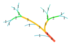
Stream Order
Strahler order
-Unbranched tributaries = 1st order
-Two 1st order streams
merge = 2nd order
-Two 2nd order streamsmerge = 3 rdorder
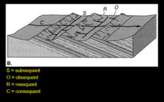
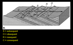
Consequent
development of trunk stream in harmony with pre-existing land surface (regional slope)
Original drainage developed on sloping surface
Volcanic cones, deglaciated regions, recently uplifted regions
Drainage patterns: dendritic, parallel, radial
Subsequent
development of main channel independent of pre-existing land surface; often involving differential erosion; may be oblique or orthogonal to regional slope
-Selective headward erosion through material of lower resistance, associated with Trellis and Rectilinear patterns
Drainage patterns: trellis, rectangular, angular, annular, and centripetal

Obsequent
trunk stream channel flowing opposite of regional slope
-Later drainages flowing in opposite direction of consequent streams, typically tributaries into the older, consequent drainage

Superposed
younger strata deposited on top of eroded, older structure
Drainage cut across structure
Result from erosion through a regional unconformity
Incision through upper strata acts as a "template" etching the stream into strata below the unconformity
Antecedent
exists before uplift of a mountain
-Drainage existing prior to folding and uplift
-Cut through uplift to form water gaps
-If stream erosion is defeated by uplift, the abandoned channel is called a WIND GAP
Abstraction
headward erosion until stream undercuts and captures another stream
-Steeper gradient
-Shorter distance to base level
-Less resistant rock to erode
Intercision
lateral movement of meanders causes two streams to intersect and one to be diverted into the other
Epigenic
near surface solution of limestone, occurs from carbonic acid(H2CO3), but phosphoric acid could also play a role
Hypogenic
results from acidification of deeper water - often occurs in hydrothermal areas (sulfuric acid (H2SO4)
Karst Denudation
removing rock mass from the landscape
weathering, erosion, and transport
-dissolution process
Rate of solution (S) = CQ
C=dissolved load, Q= discharge
Rates compare to fluvial denudation rates, due to suspended/clastic loads
Driving forces of Hillsopes and Mass Wasting
Gravity
Resisting forces of Hillsopes and Mass Wasting
friction, cohesion, shear strength