Week 7: Earthquakes
0.0(0)
Studied by 1 person Call Kai
 Learn
Learn Practice Test
 Spaced Repetition
 Match
Match Flashcards
 Knowt Play
Card Sorting
1/67

Earn XP
Description and Tags
Last updated 12:10 PM on 10/11/26
Name | Mastery | Learn | Test | Matching | Spaced | Call with Kai | Chat |
|---|
No analytics yet
Send a link to your students to track their progress
68 Terms
1
New cards
Earthquakes
They result from the rupture of rocks along a fault.
\
Energy from an earthquake is released in the form of seismic waves.
\
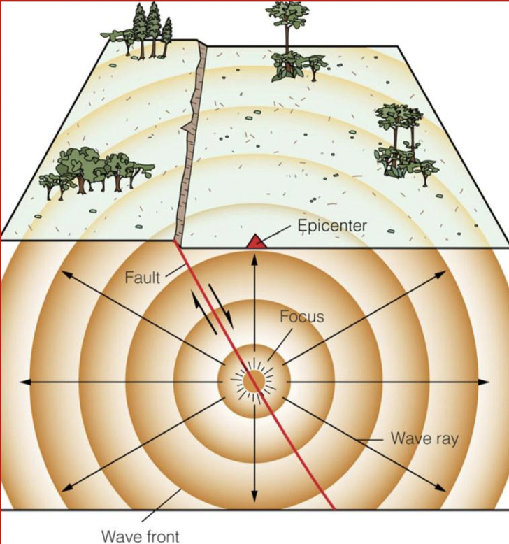
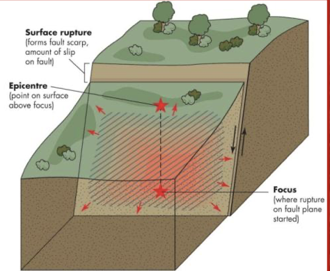
They are mapped according to the epicentre; the focus is located directly below the epicentre.
* they are measured by seismographs and compared by magnitude
\
Energy from an earthquake is released in the form of seismic waves.
\
They are mapped according to the epicentre; the focus is located directly below the epicentre.
* they are measured by seismographs and compared by magnitude
2
New cards
Earthquake magitude
The magnitude of an earthquake is expressed as a number to one decimal place.
\
This type of measurement was first developed by Richter in 1935
\
The Richter Scale was a measure of the strength of a wave 100 km from the epicentre.
\
Since then, Richter is not used anymore
\
This type of measurement was first developed by Richter in 1935
\
The Richter Scale was a measure of the strength of a wave 100 km from the epicentre.
\
Since then, Richter is not used anymore
3
New cards
The moment magnitude scale
Today, earthquakes are measured using the Moment Magnitude scale (M).
\
The scale is determined by:
* The area ruptured along a fault
* the amount of movement along the fault
* the elasticity of the crust at the focus
\
Like the Richter Scale, it is a ==logarithmic== scale.
\
**Example:**
* an M7 earthquake represents 10 times the amount of ground motion as an M6 earthquake
\
\
\
The scale is determined by:
* The area ruptured along a fault
* the amount of movement along the fault
* the elasticity of the crust at the focus
\
Like the Richter Scale, it is a ==logarithmic== scale.
\
**Example:**
* an M7 earthquake represents 10 times the amount of ground motion as an M6 earthquake
\
\
4
New cards
Example question:
Compare an M5 to an M2 -how much more shaking would there be
Compare an M5 to an M2 -how much more shaking would there be
* 1000 times
* 10 x 10 x 10 (3 times more powerful)
* 10 x 10 x 10 (3 times more powerful)
5
New cards
Magnitude and frequency
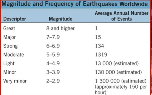
Except for very large earthquakes, the magnitude on the Moment Magnitude Scale is like the Richter Scale.
\
There are only a few M9+ earthquakes in each country
\
There are only a few M9+ earthquakes in each country
6
New cards
The strongest earthquake to ever occur
The strongest earthquake to ever occur is M9.5 in Chile
in 1960.
\
In Canada, it is M8.1 in B.C. in 1949.
in 1960.
\
In Canada, it is M8.1 in B.C. in 1949.
7
New cards
Which scale is quantitative and which is qualitative?
__**Qualitative:**__
* Modified Mercalli intensity scale
\
__**Quantitative:**__
* Moment Magnitude intensity scale
* Modified Mercalli intensity scale
\
__**Quantitative:**__
* Moment Magnitude intensity scale
8
New cards
Modified Mercalli intensity scale
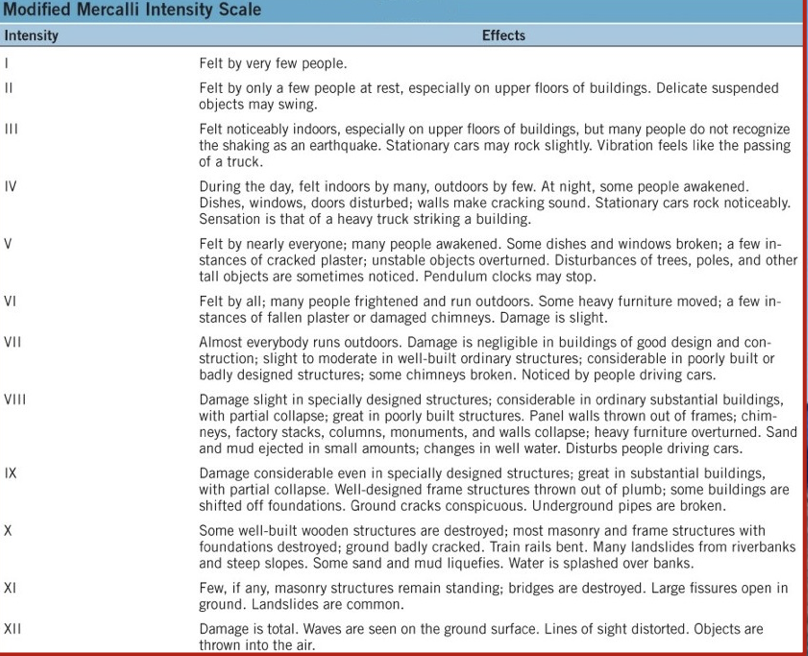
The Modified Mercalli Intensity Scale is a qualitative scale based on damage to structures and the effect on people. It is based on 12 categories.
9
New cards
Earthquakes are most common _______________
near or on plate boundaries
10
New cards
Earthquake processes
motion at plate boundaries is not usually smooth or constant
\
Friction along plate boundaries exerts a force (stress) on the rocks, exerting strain or deformation
\
When the stress exceeds the strength of the rocks, there is a sudden movement along a fault.
\
Friction along plate boundaries exerts a force (stress) on the rocks, exerting strain or deformation
\
When the stress exceeds the strength of the rocks, there is a sudden movement along a fault.
11
New cards
Seismic sources
The movement (or rupture) starts at the focus and propagates in all directions, called seismic waves.
\
Thus, faults are considered seismic sources.
\
Identifying faults is necessary to evaluate the risk of an earthquake in an area
\
Not all faults reach the earths surface. Blind faults are located below the surface
\
Thus, faults are considered seismic sources.
\
Identifying faults is necessary to evaluate the risk of an earthquake in an area
\
Not all faults reach the earths surface. Blind faults are located below the surface
12
New cards
Earthquake distribution
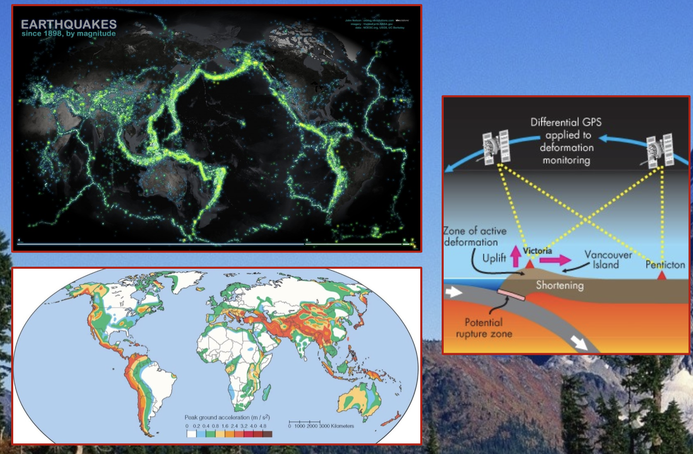
13
New cards
fault types
There are __**two**__ basic types of geologic faults distinguished by the direction of the displacement of rock or sediment.
14
New cards
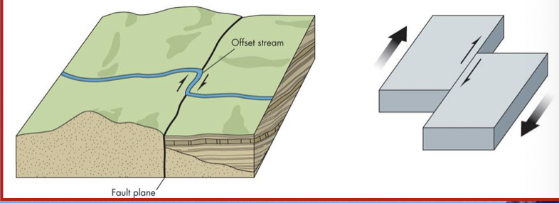
Strike-slip faults
\
Displacements are ^^horizontal^^
\
example: San Andreas Fault
Displacements are ^^horizontal^^
\
example: San Andreas Fault
15
New cards
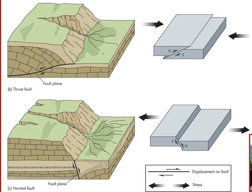
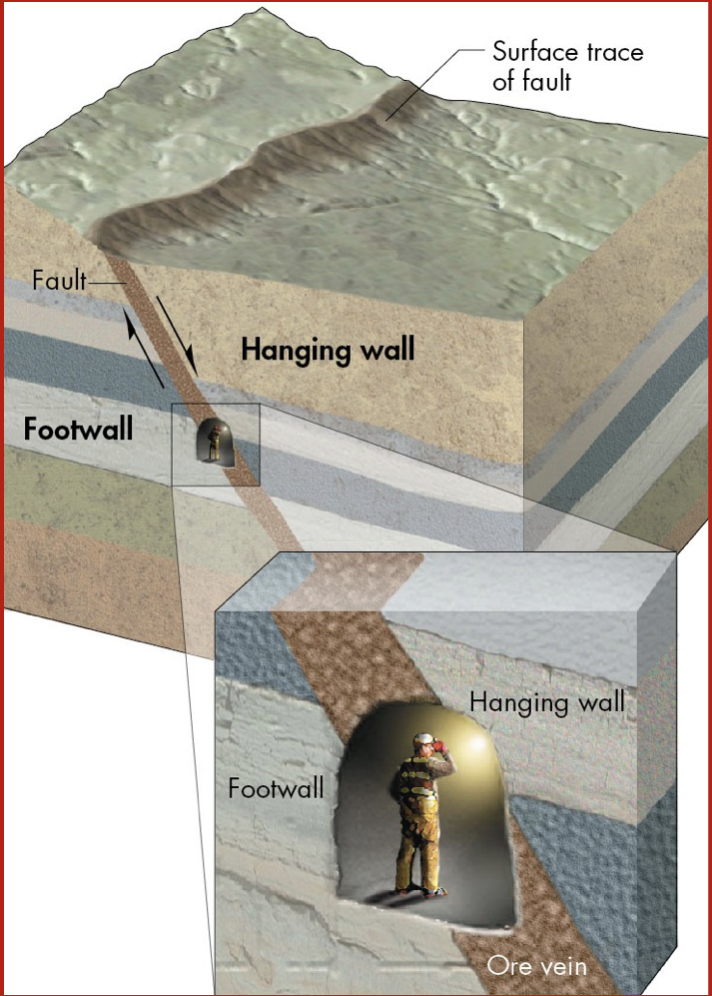
Dip-slip faults
Displacements are vertical
\
three types:
* Reverse fault
* Thrust fault
* Normal fault
\
Comprised of two walls on an incline defined by minors:
\
1. Footwall (where minors placed their feet)
2. Hanging wall (where minors placed their lanterns)
\
three types:
* Reverse fault
* Thrust fault
* Normal fault
\
Comprised of two walls on an incline defined by minors:
\
1. Footwall (where minors placed their feet)
2. Hanging wall (where minors placed their lanterns)
16
New cards
Reverse fault
The hanging wall has moved up relative to the footwall at an angle steeper than 45 degrees
17
New cards
Thrust fault
These are like reverse faults except th angle is 45 degrees or less
18
New cards
Normal fault
The hanging wall has moved down relative to the footwall
19
New cards
Fault activity
In terms of activity, faults can fall into one of three categories:
\
__**Active**__
* movement during the past ==11, 600 years== (based on geologic time scale)
\
__**Potentially Active**__
* movement during the past 2.6millionyears
\
__**Inactive**__
* nomovement during the past 2.6millionyears
\
\
__**Active**__
* movement during the past ==11, 600 years== (based on geologic time scale)
\
__**Potentially Active**__
* movement during the past 2.6millionyears
\
__**Inactive**__
* nomovement during the past 2.6millionyears
\
20
New cards
Tectonic creep
Definition:
* The low movement of rock or sediment along a fracture caused by stress
\
It is also referred to as *fault creep*.
\
This can damage roads and building foundations (movement of a few cm per decade).
\
Along these faults, periodic sudden displacements producing earthquakes can also occur
* The low movement of rock or sediment along a fracture caused by stress
\
It is also referred to as *fault creep*.
\
This can damage roads and building foundations (movement of a few cm per decade).
\
Along these faults, periodic sudden displacements producing earthquakes can also occur
21
New cards
Seismic waves
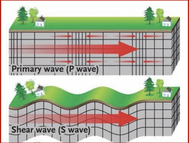
Some seismic waves generated by fault rupture travel within the body of the Earth and others travel along the surface.
\
__**Body waves:**__
* These include P waves and S waves
\
__**P waves:**__
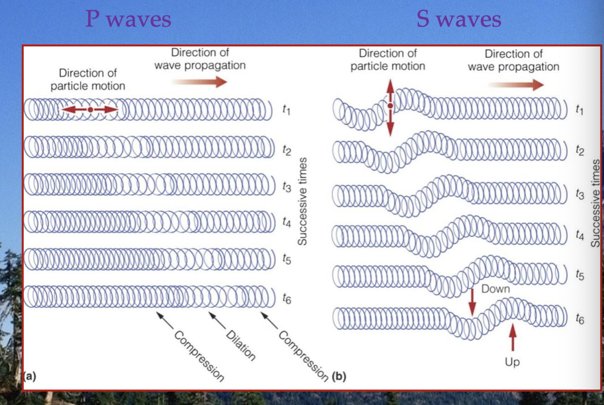
* they also called primary or compressional waves
\
They move fast with a push-pull motion and can travel through solids or liquids
\
__**Body waves:**__
* These include P waves and S waves
\
__**P waves:**__
* they also called primary or compressional waves
\
They move fast with a push-pull motion and can travel through solids or liquids
22
New cards
S wave
also called secondary or shear waves
* move slowly, in an up-and-down motion and can onlytravelthroughsolids
* move slowly, in an up-and-down motion and can onlytravelthroughsolids
23
New cards
P waves vs S waves
24
New cards
Surface waves
Definition:
* seismic waves that form when P and S waves reach the surface and then move along it
\
These waves move more slowly than body waves.
* seismic waves that form when P and S waves reach the surface and then move along it
\
These waves move more slowly than body waves.
25
New cards
Earthquake shaking
Factors that determine the shaking people experience during an earthquake:
* magnitude
* distance to the epicentre
* focal depth
* direction of rupture
* local soil and rock types
* local engineering and construction practices
* magnitude
* distance to the epicentre
* focal depth
* direction of rupture
* local soil and rock types
* local engineering and construction practices
26
New cards
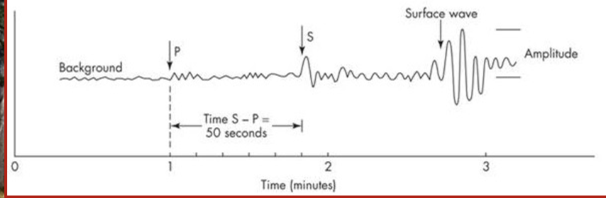
Seismographs record the arrival of waves to a recording station.
Because P waves travel faster than S waves , they appear first on a seismograph
\
Earthquake shaking decreases with distance from the epicentre
\
Earthquake shaking decreases with distance from the epicentre
27
New cards
Distance to the epicentre
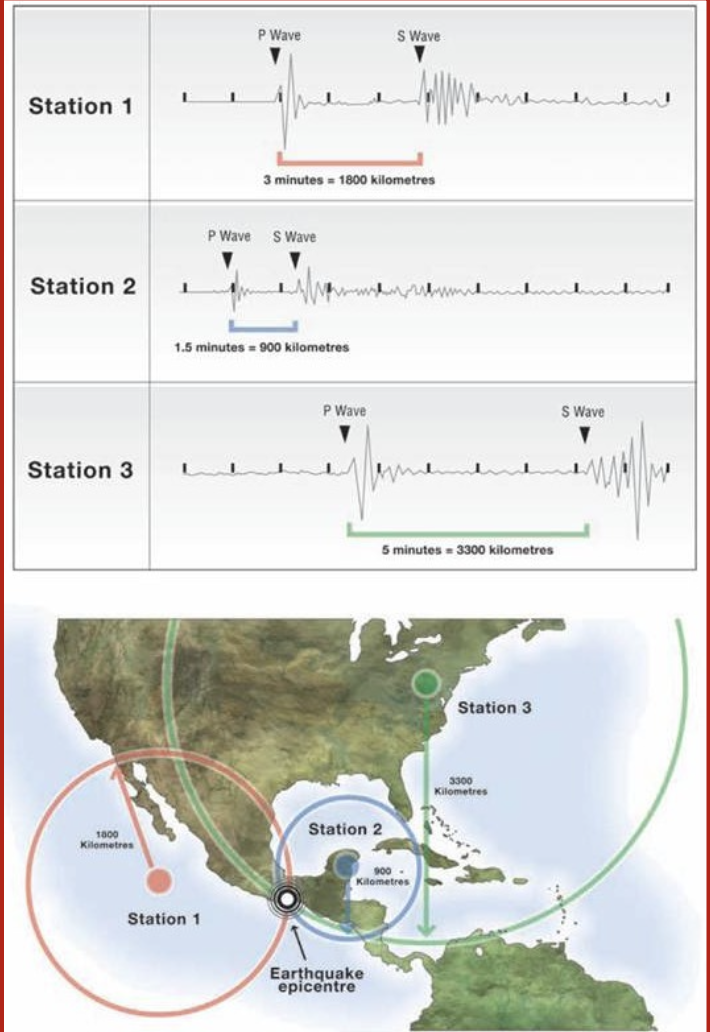
The difference between the arrival times of the first P and S waves at different locations determine the distance to the epicentre.
\
The distance to the epicentre is calculated at __**3**__ different seismic stations
\
A circle with radius equal to that distance is drawn around the station
\
The distance to the epicentre is calculated at __**3**__ different seismic stations
\
A circle with radius equal to that distance is drawn around the station
28
New cards
Locating an earthquake
The epicentre is located where the circles intersect; this process is called *triangulation*.
\
\*must use 3!!!
\
\*must use 3!!!
29
New cards
Focal depth
Seismic waves become less intense as they spread outward toward the surface.
\
Therefore, the greater the focal depth, the less intense the shaking at the surface.
\
This reduction of energy is referred to as %%**attenuation**%%
\
Therefore, the greater the focal depth, the less intense the shaking at the surface.
\
This reduction of energy is referred to as %%**attenuation**%%
30
New cards
Direction of rupture
Earthquake energy is focused along the direction of rupture.
\
This is known as directivity and contributes to increased shaking.
\
Radiated waves are sometimes stronger in one direction along the fault
\
This is known as directivity and contributes to increased shaking.
\
Radiated waves are sometimes stronger in one direction along the fault
31
New cards
Local soil and rock types
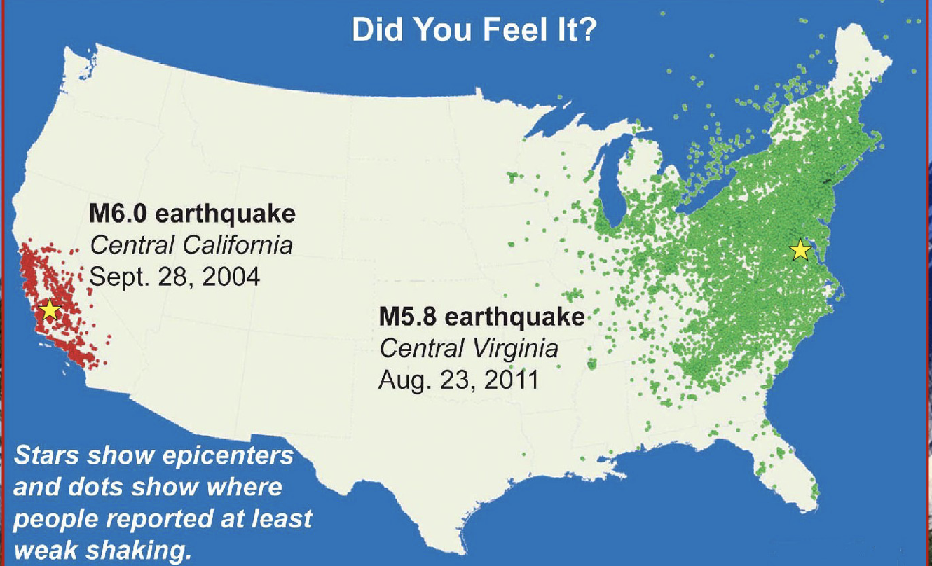
The local geology influences the amount of ground motion.
\
* Dense homogenous crust can transmit earthquake energy quickly
\
Seismic energy slows down in areas with heterogeneous, folded, faulted crust.
\
**Implication:**
* Earthquakes in eastern North America are felt over larger areas than those in western North America
\
* Dense homogenous crust can transmit earthquake energy quickly
\
Seismic energy slows down in areas with heterogeneous, folded, faulted crust.
\
**Implication:**
* Earthquakes in eastern North America are felt over larger areas than those in western North America
32
New cards
Amplification
definition:
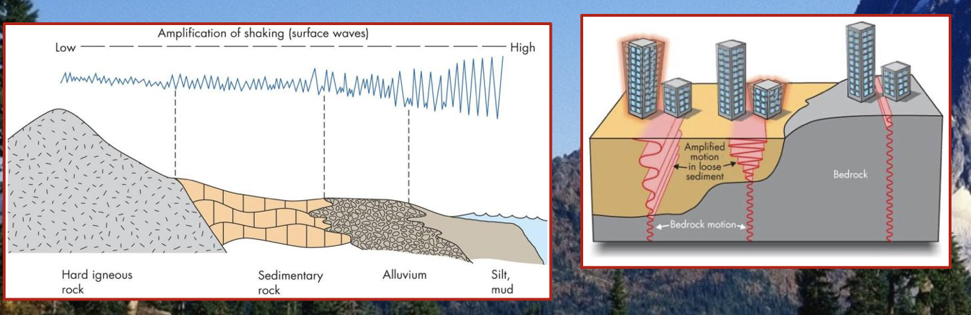
* An increase in ground motion during an earthquake
\
\
P and S waves slow as they travel through alluvial sand, gravel, clay, soil, etc.
\
As the waves slow, some of their energy is transferred to surface waves
* An increase in ground motion during an earthquake
\
\
P and S waves slow as they travel through alluvial sand, gravel, clay, soil, etc.
\
As the waves slow, some of their energy is transferred to surface waves
33
New cards
Alluvial
soil that was deposited by water
34
New cards
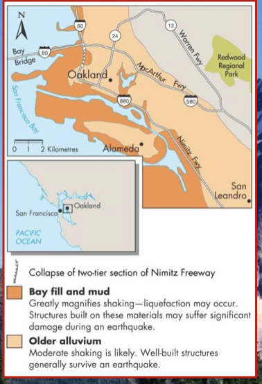
amplification has historically enhanced damage in *__________________* area earthquakes
San Fransisco
35
New cards
Shake maps
The combination of all these effects results in widespread variation of the shaking felt in the vicinity of an earthquake.
\
Therefore, two earthquakes that have the same magnitude can have very different impacts
\
(why we have 2 scales)
\
Therefore, two earthquakes that have the same magnitude can have very different impacts
\
(why we have 2 scales)
36
New cards
The earthquake cycle
Definition:
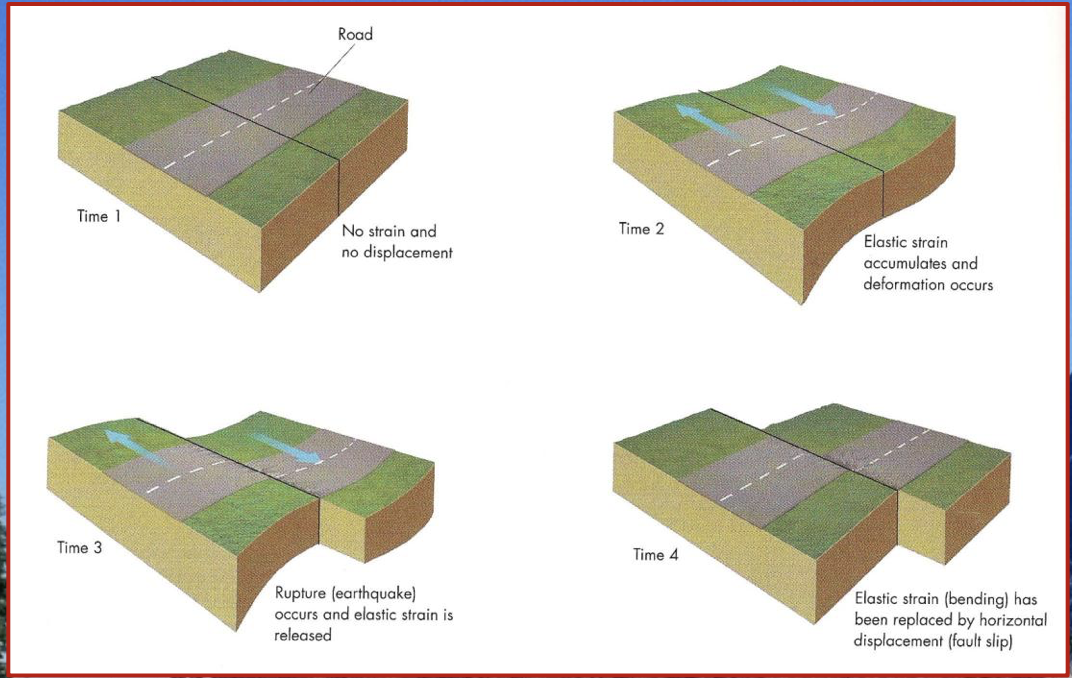
* A hypothesis that explains successive earthquakes on a fault
\
It is based on the idea that *strain* drops abruptly after an earthquake and then slowly accumulates until the next earthquake.
\
\
* A hypothesis that explains successive earthquakes on a fault
\
It is based on the idea that *strain* drops abruptly after an earthquake and then slowly accumulates until the next earthquake.
\
\
37
New cards
The cycle stages
A typical cycle has several stages:
\
* an inactive period
* a period where the *mainshock* occurs allowing the fault to release built-up stress
* a period where strain produces minor earthquakes
* a period of foreshocks prior to a major release of stress
\
\
The time between each stage varies.
\
* an inactive period
* a period where the *mainshock* occurs allowing the fault to release built-up stress
* a period where strain produces minor earthquakes
* a period of foreshocks prior to a major release of stress
\
\
The time between each stage varies.
38
New cards
foreshock
a small to moderate earthquake that occurs before a large earthquake in the general vicinity of the large earthquake
39
New cards
mainshock
The largest earthquake in a series of associated earthquakes
40
New cards
aftershock
a small to moderate earthquake that occurs after a large earthquake in the general vicinity of the large earrthquake
41
New cards
Aftershocks
Generally, the number of aftershocks that occur on a given day after a mainshock can be forecasted by a formula:
\
\
Example: If 200 aftershocks occurred on the first day after the mainshock, how many aftershocks are likely to occur on the 7th day after the mainshock?
\
200 divided 7 = 29
\
\
Example: If 200 aftershocks occurred on the first day after the mainshock, how many aftershocks are likely to occur on the 7th day after the mainshock?
\
200 divided 7 = 29

42
New cards
Geographic regions at risk from earthquakes
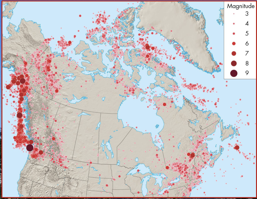
Earthquakes are not randomly distributed.
\
Most earthquakes occur along plate boundaries:
* Pacific ring of fire
* Himilaya mountains
* Middle east
\
North American cities at high risk of earthquakes:
* Anchorage, Vancouver, Victoria, Seattle, Portland, San Francisco, Los Angeles, Mexico City
\
However, not all areas at risk of earthquakes are near plate boundaries.
\
Most earthquakes occur along plate boundaries:
* Pacific ring of fire
* Himilaya mountains
* Middle east
\
North American cities at high risk of earthquakes:
* Anchorage, Vancouver, Victoria, Seattle, Portland, San Francisco, Los Angeles, Mexico City
\
However, not all areas at risk of earthquakes are near plate boundaries.
43
New cards
Plate boundary earthquakes
* what are the 3 types?
* what are the 3 types?
Definition:
* earthquakes that occur on lithospheric plates
\
\
There are three types:
* Strike-slip earthquakes
* Thrust earthquakes
* normal fault earthquakes
* earthquakes that occur on lithospheric plates
\
\
There are three types:
* Strike-slip earthquakes
* Thrust earthquakes
* normal fault earthquakes
44
New cards
Strike-slip earthquakes
These earthquakes occur along %%transform faults%% where plates slide horizontally past one another.
\
* Common in California along the San Andreas fault
\
The best-known strike-slip earthquake is the Loma Prieta earthquake that disrupted the 1989 World Series in Oakland, California.
\
* Common in California along the San Andreas fault
\
The best-known strike-slip earthquake is the Loma Prieta earthquake that disrupted the 1989 World Series in Oakland, California.
45
New cards
Thrust earthquakes
\
These earthquakes occur on ^^faults that separate converging plates^^.
\
They are also called subduction earthquakes.
\
They are common off the coast of B.C. Washington and Oregon
\
These earthquakes are __**strongest**__ on earth (some are larger than M9) and can produce tsunamis
These earthquakes occur on ^^faults that separate converging plates^^.
\
They are also called subduction earthquakes.
\
They are common off the coast of B.C. Washington and Oregon
\
These earthquakes are __**strongest**__ on earth (some are larger than M9) and can produce tsunamis
46
New cards
Normal fault earthquakes
These earthquakes occur on faults associated with divergent plate boundaries.
\
* Common along the Mid-Atlantic ridge
\
Most are located under Oceans and are generally smaller than M6
\
* Common along the Mid-Atlantic ridge
\
Most are located under Oceans and are generally smaller than M6
47
New cards
Intraplate earthquakes
Definition:
* an earthquake on a fault in the interior of a continent, far from a plate boundary
\
These earthquakes are typically smaller than plate boundary earthquakes.
\
However, damage could be considerable due to lack of preparedness
* an earthquake on a fault in the interior of a continent, far from a plate boundary
\
These earthquakes are typically smaller than plate boundary earthquakes.
\
However, damage could be considerable due to lack of preparedness
48
New cards
Intraplate earthquake examples
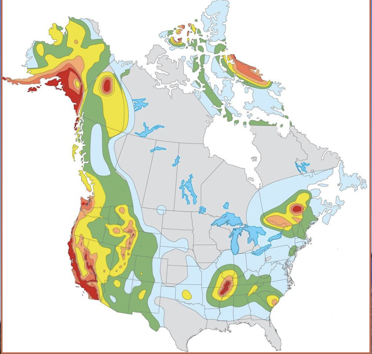
Because of dense continental bedrock, these earthquakes are felt over large areas.
\
There are two relatively active intraplate zones in North America:
* Central Mississippi River valley
* St. Lawrence river valley
\
The New Madrid earthquakes in Missouri (1811-12) were over M7.5 and felt over the entire continent.
\
Recurrence interval in this area is likely several hundred years
\
There are two relatively active intraplate zones in North America:
* Central Mississippi River valley
* St. Lawrence river valley
\
The New Madrid earthquakes in Missouri (1811-12) were over M7.5 and felt over the entire continent.
\
Recurrence interval in this area is likely several hundred years
49
New cards
recurrence interval
The time between successive (or consecutive) events
50
New cards
effects of earthquakes
Several different effects related to earthquakes contribute to deaths and property destruction.
\
Primary effects:
* ground shaking
* surface rupture
\
Secondary effects:
* liquefaction
* Land-level change
* landslides
* fire
* tsunamis
\
Primary effects:
* ground shaking
* surface rupture
\
Secondary effects:
* liquefaction
* Land-level change
* landslides
* fire
* tsunamis
51
New cards
surface rupture
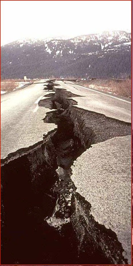
Displacement along faults causes cracks in the surface.
* during strong earthquakes, fault scarps can be produced that extend for hundreds of kilometers
* during strong earthquakes, fault scarps can be produced that extend for hundreds of kilometers
52
New cards
fault scarp
A linear escarpment along a fault where a vertical displacement has occurred
53
New cards
Surface rupture
Surface rupture can uproot trees, collapse buildings, and destroy bridges, tunnels, and pipelines.
54
New cards
Liquefaction
Definition:
The transformation of water-saturated sediment from solid to liquid
\
This may occur during strong earthquakes when water pressure becomes high enough to suspend particles of sediment within the soil.
\
Once pressure decreases, the sediment compacts and regains its strength
The transformation of water-saturated sediment from solid to liquid
\
This may occur during strong earthquakes when water pressure becomes high enough to suspend particles of sediment within the soil.
\
Once pressure decreases, the sediment compacts and regains its strength
55
New cards
Liquefaction
Watery sand and silt may flow upward along fractures in the overlying solid material.
\
This effect can cause extensive damage.
\
This effect can cause extensive damage.
56
New cards
Landslides
Ground shaking produced by an earthquake can cause rock and sediment to move downslope.
\
* A single earthquake in a mountainous area can cause thousands of landslides
\
* A single earthquake in a mountainous area can cause thousands of landslides
57
New cards
Fires
Ground shaking and rupture can sever power and gas lines, starting fires.
\
Appliances may topple over causing gas leaks that ignite
\
Approximately __**80%**__ of the damage during 1906 San Francisco earthquake was caused by fire 🔥
\
Appliances may topple over causing gas leaks that ignite
\
Approximately __**80%**__ of the damage during 1906 San Francisco earthquake was caused by fire 🔥
58
New cards
Natural service functions of earthquakes
Faults provide pathways for the downward flow of surface water.
\
They can channel groundwater to surface discharge points (springs)
\
New mineral resources can be found, some minerals are preferentially deposited in faults
\
Scenic landscapes (hills, valleys) can develop in fault zones over millions of years.
\
They can channel groundwater to surface discharge points (springs)
\
New mineral resources can be found, some minerals are preferentially deposited in faults
\
Scenic landscapes (hills, valleys) can develop in fault zones over millions of years.
59
New cards
Earthquakes caused by human activity
Several human activities are known to trigger small to moderate earthquakes.
\
The weight from water reservoirs produced by dams can create new faults
\
Injecting liquid waste deep in the earth can increase pressure and cause slippage along fractures
\
Testing nuclear weapons leads to explosions that may increase strain in an area.
\
The weight from water reservoirs produced by dams can create new faults
\
Injecting liquid waste deep in the earth can increase pressure and cause slippage along fractures
\
Testing nuclear weapons leads to explosions that may increase strain in an area.
60
New cards
Minimizing the earthquake hazard
Earthquakes cause death and destruction because they often occur with little warning.
\
At present, we can forecast the likelihood that an earthquake will occur in an area, but not exactly when it will occur
\
The geological surveys of Canada and the U.S are developing programs to reduce the hazard from earthquakes
\
At present, we can forecast the likelihood that an earthquake will occur in an area, but not exactly when it will occur
\
The geological surveys of Canada and the U.S are developing programs to reduce the hazard from earthquakes
61
New cards
Earthquake hazard reduction programs
The programs have 5 goals:
* improve national seismograph networks
* develop awareness of earthquake sources
* determine earthquake potential
* predict effects of earthquakes on buildings
* communicate research to educate the public
* improve national seismograph networks
* develop awareness of earthquake sources
* determine earthquake potential
* predict effects of earthquakes on buildings
* communicate research to educate the public
62
New cards
Planning for earthquakes
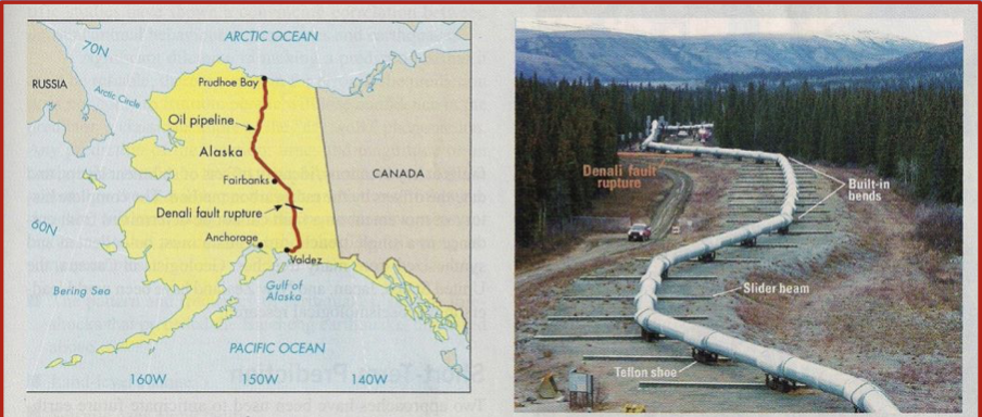
The denali earthquake in Alaska (2002) demonstrated the value of planning for earthquakes
\
Where the Trans-Alaska oil pipeline crossed the Denali fault, its construction was altered to withstand a large earthquake.
\
Where the Trans-Alaska oil pipeline crossed the Denali fault, its construction was altered to withstand a large earthquake.
63
New cards
Estimating seismic risk
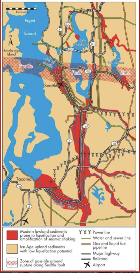
Hazard maps identify areas of risk associated with earthquake effects.
\
They include areas prone to liquefaction, zones of possible ground rupture and historic epicentres
\
They include areas prone to liquefaction, zones of possible ground rupture and historic epicentres
64
New cards
Precursers to earthquakes
If accurate forecasts are possible, they will most likely be based on precursors:
1. **The pattern and frequency of earthquakes**
* based on foreshocks and microearthquakes
\
2. **Land-level change**
* uplift or subsidence may precede earthquakes
* GPS stations can recognize small changes in elevation
\
3. **Seismic gaps along faults**
* areas along a fault that have not seen recent earthquakes may be a more likely to experience one
\
4. **Physical and chemical changes**
* Changes in groundwater levels and chemistry may occur if rocks expand prior to an earthquake
1. **The pattern and frequency of earthquakes**
* based on foreshocks and microearthquakes
\
2. **Land-level change**
* uplift or subsidence may precede earthquakes
* GPS stations can recognize small changes in elevation
\
3. **Seismic gaps along faults**
* areas along a fault that have not seen recent earthquakes may be a more likely to experience one
\
4. **Physical and chemical changes**
* Changes in groundwater levels and chemistry may occur if rocks expand prior to an earthquake
65
New cards
Earthquake forecasting
There have been modest incidences of successfully forecasting earthquakes.
* all forecasts must be scientifically reviewed before they are released
\
Research projects along the San Andreas Fault are aiding in understanding the conditions that occur before an earthquake.
\
Current earthquake warning systems provide 15 to 30 seconds of warning and only warn of an earthquake that has already occurred.
* all forecasts must be scientifically reviewed before they are released
\
Research projects along the San Andreas Fault are aiding in understanding the conditions that occur before an earthquake.
\
Current earthquake warning systems provide 15 to 30 seconds of warning and only warn of an earthquake that has already occurred.
66
New cards
Perception of the earthquake hazard
Survivors of strong earthquakes often report traumatic stress.
\
Typically, one communities experienced with an earthquake has not stimulated other communities to enhance their preparedness
\
\
Earthquakes have exposed shoddy construction practices.
\
Typically, one communities experienced with an earthquake has not stimulated other communities to enhance their preparedness
\
\
Earthquakes have exposed shoddy construction practices.
67
New cards
Community adjustments to the earthquake hazard
It is not possible to prevent people from living in earthquake prone areas.
\
Therefore, we must take several steps to minimize seismic risk:
\
* critical facilities should be located as safely as possible
\
* buildings must be designed to withstand vibrations (in many cases, retrofitting is required)
* education is a component of preparedness (workshops, training sessions, earthquake drills)
\
* earthquake insurance should be made available
\
Therefore, we must take several steps to minimize seismic risk:
\
* critical facilities should be located as safely as possible
\
* buildings must be designed to withstand vibrations (in many cases, retrofitting is required)
* education is a component of preparedness (workshops, training sessions, earthquake drills)
\
* earthquake insurance should be made available
68
New cards
Personal adjustments
Most earthquake casualties result from building collapse and falling objects.
\
During an earthquake, it is best to stay away from windows and tall furniture.
\
The safest locations are under desks or tables
\
During an earthquake, it is best to stay away from windows and tall furniture.
\
The safest locations are under desks or tables