Chapter 1: The Living World: Ecosystems
1.1: Introduction to Ecosystems
- Ecosystem: A community of living (biotic) organisms interacting with the non-living (abiotic) components of their environment as a system through various nutrients and energy cycles.
Biological Populations and Communities
- Organism: A living thing that can function on its own.
- Species: Organisms that resemble each other; are similar in genetic makeup, chemistry, and behavior; and are able to interbreed and produce fertile offspring.
- Interspecific: Means between different species.
- Population: Organisms of the same species that interact with each other and occupy a specific area.
- Community: Population of different species.
Ecological Niches
- Ecological Niche: A particular area within a habitat occupied by an organism, as well as the function of that organism within its ecological community.
- Physical environment: It influences how organisms affect and is affected by resources and competitors.
- Niche: It reflects the specific adaptations that a species has acquired through evolution.
- Characteristics of a niche include:
- Habitat.
- Interactions with living and nonliving factors.
- place/role in the food web.
- Types and amounts of resources available.
Generalists vs. Specialists Species
| Generalists | Specialists |
|---|---|
| Able to survive on a wide variety of food resources | Specific/limited number of prey |
| Able to withstand a wide range of environmental conditions | Prone to extinction, sensitive to environmental change |
| Live in broad niches | Live in narrow niches; e.g., pandas |
| Examples: cockroaches, humans, mice | Examples: Giant pandas, koalas, mountain gorillas. |
Interactions Among Species
- Symbiosis: A term used to describe any type of %%close and long-term biological interaction between two different biological organisms of the same or different species%%.
Symbiotic Interactions
- Amensalism: The interaction between two species whereby %%one species suffers and the other species is not affected%%.
- Example: The black walnut tree releases a chemical that kills neighboring plants.
- Commensalism: The interaction between two species whereby %%one organism benefits and the other species is not affected%%.
- Forms of commensalism include:
- using another organism for transportation
- using another organism for housing, and
- using something that another organism created.
- Competition: It can be either intraspecific and interspecific.
- It is the driving force of evolution whether it is for food, mating partners, or territory.
- Intraspecific: Competition between members of the same species.
- Interspecific: competition between members of different species.
- Competition is prominent in predator–prey relationships, with the predator seeking food and the prey seeking survival.
- Mutualism: The interaction between %%two species whereby both species benefit%%.
- Parasitism: The interaction between %%two species whereby one species is benefited, and the other species is harmed%%.
- Predation: Predators hunt and kill their prey.
- Opportunistic predators kill and eat almost anything.
- Specialist predators only prey upon certain organisms.
- Saprottrophism: Saprotrophs obtain their nutrients from %%dead or decaying plants or animals through the absorption%% of soluble organic compounds.
Law of Tolerance
Law of Tolerance: It states that the existence, abundance, and distribution of species depend on the tolerance level of each species to both physical and chemical factors.
- Some factors can control an organism's abundance or distribution if they exceed its tolerance limits.
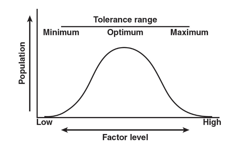
Limiting Factors
- Limiting Factor: Any abiotic factor that limits or prevents the growth of a population.
- Limiting factors in terrestrial ecosystems may include:
- the level of soil nutrients,
- the available amount of water and light, and
- the temperature
- In aquatic ecosystems, major limiting factors may include:
- the pH of the water,
- the amount of dissolved oxygen, light, or
- the degree of salinity.
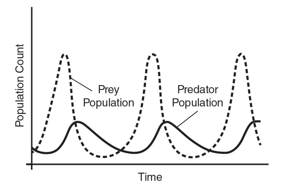
Predator-Prey Relationship
Predator-prey cycles are based on a feeding relationship between two species:
- If the prey species rapidly multiply, the number of predators increases until the predators eventually eat so many of the prey that the prey population dwindles again.
Resource Partitioning
- Morphological partitioning: It occurs when two species share the %%same resource but have evolved slightly different structures to utilize the same resource%%
- Spatial partitioning: It occurs when competing species use the %%same resource by occupying different areas or habitats within the range of occurrence of the resource%%
- Temporal partitioning: It occurs when two species %%eliminate direct competition by utilizing the same resource at different times%%
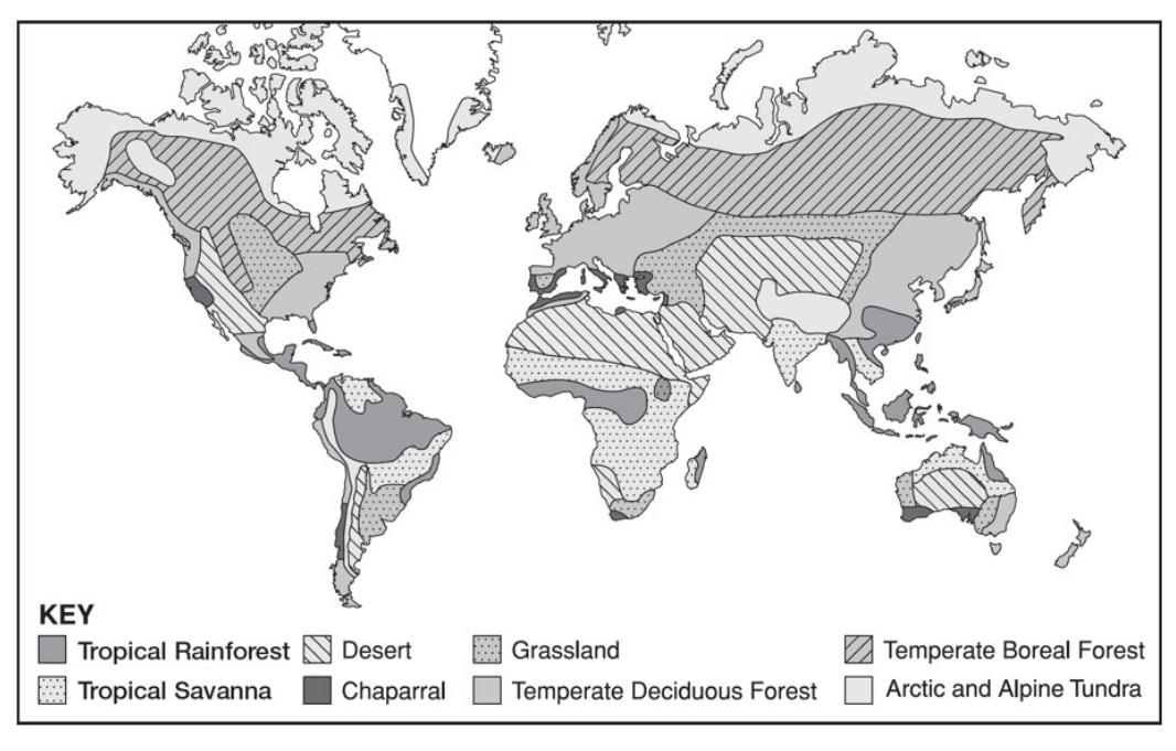
1.2: Terrestrial Biomes
Biomes: These are major regional or global biotic communities characterized by dominant forms of plant life and the prevailing climates
- Temperature and precipitation are the most important determinants of biomes.
Many places on Earth %%share similar climatic conditions%% despite being located in different areas.
Most terrestrial biomes are identified by the plant life primarily found within them.
The geographical distribution of the various terrestrial biomes is controlled primarily by the %%average air temperature and the amount of rainfall the biome receives%%.
Deserts
Deserts: Defined in terms of the amount of rainfall they receive, not temperature.
- They cover about 20% of Earth’s surface and occur where rainfall is less than 20 inches (50 cm) per year.
- Daily extremes in temperature result from exceptionally %%low humidity as water vapor tends to block solar radiation%%.
- Most deserts are located between 15° and 35° north and south latitudes.
- Arctic tundra is a cold desert due to the low amount of rainfall it receives yearly.
Succulents
- Plants that have fleshy leaves or stems that store water.
- They have:
- deep roots to tap groundwater;
- open stomata at night;
- shallow roots to collect and store water after short rainfalls;
- small surface areas exposed to sunlight;
- vertical orientation to minimize exposure to the sun; and
- waxy leaves to minimize transpiration.
Cactus
- They have sharp spines that create shade, reduce drying airflow, discourage herbivores and reflect sunlight.
- They also secrete toxins into the soil to prevent interspecific completion.
Wildflowers
- They are are dependent on water for germination;
- They have short life spans;
- They perform their entire life cycle from seed to flower to seed within a single growing season; and
- They store biomass in seeds.
Desert animals:
- They are generally small.
- They are often nocturnal.
- They have small surface areas.
- They spend time in underground burrows where it is cold.
Aestivation: A summer hibernation.
Forests
- Forests cover about one-third of Earth's land surface, mostly in North America, the Russian Federation, and South America, and account for 75% of gross primary productivity and plant biomass.
- Ecozones like boreal forests near the poles and tropical forests near the equator are %%formed by forests at different latitudes and elevations%%.
- Forest Layers
- Closed canopy: Tree crowns cover more than 20% of the ground’s surface.
- The majority (80%) of the forest biome.
- Open canopy: Tree crowns cover less than 20% of the ground surface.
Tropical Rainforests
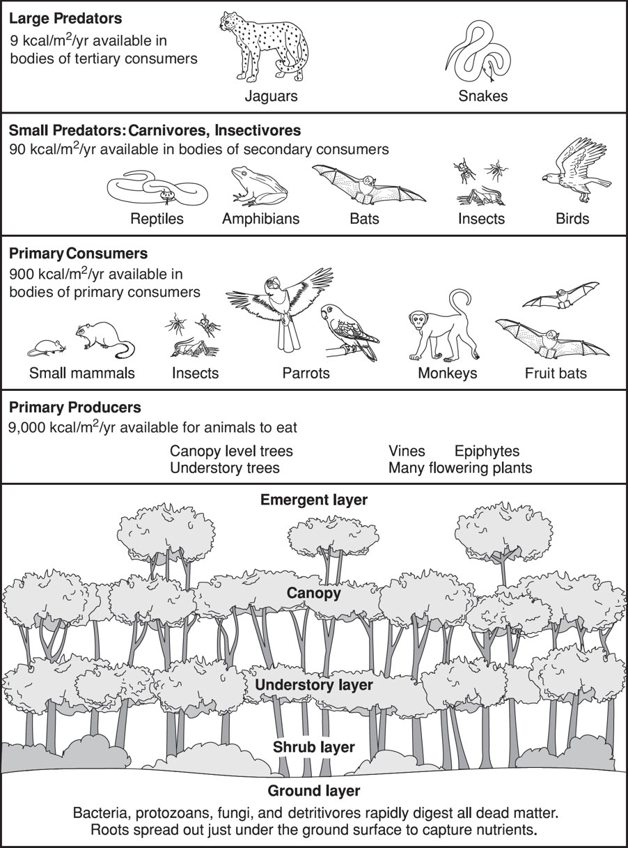
Animals include numerous birds, bats, small mammals, and insects.
Decomposition is rapid and soils are subject to heavy leaching.
Distinct seasonality where winter is absent and only two seasons are present.
The length of daylight is 12 hours and varies a little year-round
Large diversity of species.
Occur near the equator.
Annual rainfall exceeds 80 inches (200 cm) and is evenly distributed.
Plants are highly diverse.
Most nutrients are rapidly assimilated and stored in plant tissue, leaving soil nutrient-poor.
Temperature is warm to hot and varies little throughout the year.
Tree canopy is multilayered and continuous, allowing little light penetration.
Trees have buttressed trunks, shallow roots, and large, dark green leaves.
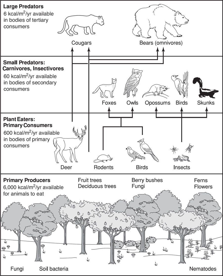
Temperate Deciduous Forests
Occur in eastern North America, northeastern Asia, and western and central Europe.
Have a distinct winter, moderate climate, and a 140–200-day growing season during four to six frost-free months.
Temperature varies from –20°F to 85°F (–30°C to 30°C).
Precipitation averages 30–60 inches (75–150 cm) per year.
Fertile soil is enriched by decaying leaf litter.
The tree canopy allows light to penetrate, resulting in well-developed and diverse understory vegetation and animal stratification.
Oaks, hickories, beeches, hemlocks, maples, cottonwoods, elms, willows, and spring-flowering herbs are deciduous trees.
Birds, squirrels, rabbits, skunks, deer, mountain lions, bobcats, timber wolves, foxes, and black bears live there.
Development, land clearing, and timbering have left few temperate forests.
Temperate Coniferous Forest
Found in temperate regions with warm summers, cool winters, and enough rainfall to support forests.
Common in coastal areas with mild winters and heavy rainfall, or inland in drier climates or mountains.
These forests have cedar, cypress, fir, juniper, pine, redwood, and spruce.
These forests have two layers:
- Overstory: The uppermost trees in a forest.
- Understory: Layer made up of young trees, short species of trees, shrubs, and soft-stemmed plants.
Some forests have a shrub layer.
Grassy understories in pine forests often burn in ecologically important wildfires.
The understory has many herbaceous and shrub species.
Conical trees shed snow and protect branches.
Dark green needles absorb more light for photosynthesis.
As temperatures rise, trees can start photosynthesis with their year-round needles.
- Needles have thick waxy coatings, waterproof cuticles, and sunken stomates.
- Needles reduce transpiration by reducing surface area.
In winter, when food is scarce, many animals hibernate to conserve energy and build fat in summer.
Birds have feathers and many animals have thick fur to protect them from cold weather.
Some animals migrate to warmer climates during the winter months.
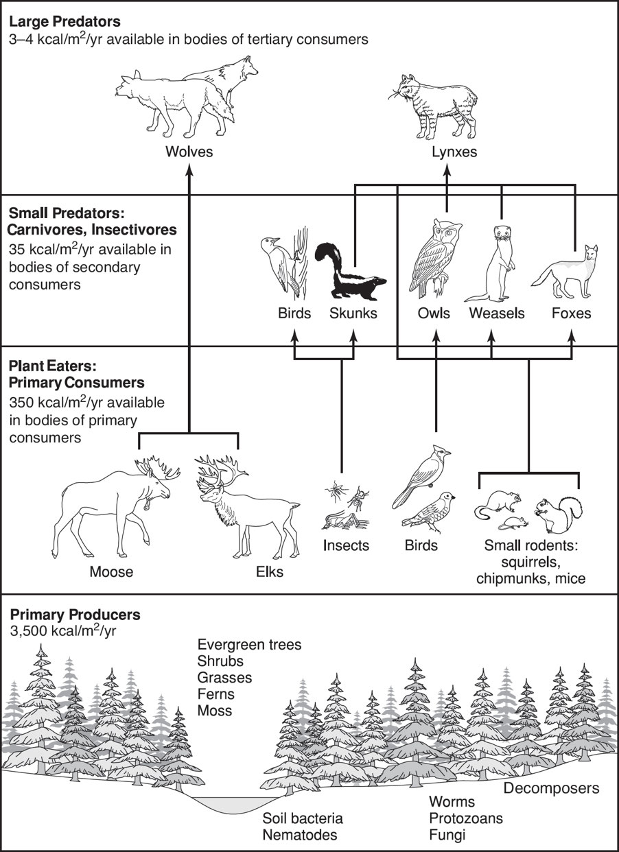
Taiga
Taiga: Largest terrestrial biome; found in northern Eurasia, North America, Scandinavia, and two-thirds of Siberia.
Southern Taiga: Also known as boreal forest, consists primarily of cold-tolerant evergreen conifers with needle-like leaves, such as pines, spruces, and larches.
Northern Taiga: It is more barren as it approaches the tree line and the tundra biome.
The harsh climate in the taiga limits both productivity and resilience.
- Cold temperatures, wet soil during the growing season, and needle and moss acids slow organic matter decay.
Seasons are divided into:
- Short, moist, moderately warm summers
- Long, dry, freezing winters.
Soil is thin, nutrient-poor, and acidic.
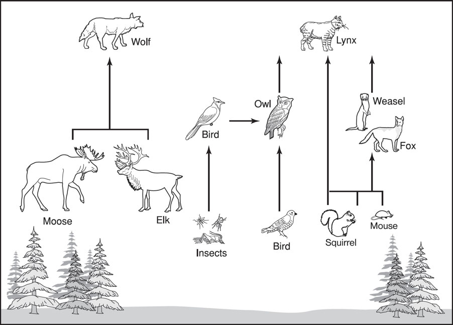
Animals include woodpeckers, hawks, moose, bears, weasels, lynxes, deer, hares, chipmunks, shrews, and bats.
Grasslands
- Grasslands are characterized as lands dominated by grasses rather than by large shrubs or trees.
- There are two main divisions of grasslands:
- savannas or tropical grasslands; and
- temperate grasslands.
Savannas
Savannas: These are grasslands with scattered individual trees and cover almost half the surface of Africa and large areas of Australia, South America, and India.
Savannas are found in warm or hot climates with an annual rainfall of 20 to 50 inches (50–130 cm) concentrated in six to eight months, followed by a long drought when fires can occur.
Savanna soil drains quickly and has a thin layer of humus to nourish vegetation.
- Grass and small broad-leafed plants dominate.
- Deciduous trees and shrubs are scattered across the open landscape.
- Seasonal fires help savannas' biodiversity during dry and rainy seasons.
Animals include buffaloes, elephants, giraffes, ground squirrels, hyenas, kangaroos, leopards, lions, mice, snakes, termites, and zebras.
Temperate Grassland
Temperate Grasslands: Here grasses are the dominant vegetation, while trees and large shrubs are absent.
Examples of temperate grasslands include
- the veldts of South Africa,
- the pampas of Argentina,
- the steppes of Russia, and
- the plains and prairies of central North America.
Climate is characterized by hot summers and cold winters, and rainfall is moderate.
- Taller grasses grow in wetter areas.
- Drought and fires affect biodiversity in the savanna.
Deep, multi-branched grass roots grow and decay in the dark, fertile soil, enriching it.
- Rotted roots bind to soil and feed plants.
Seasonal drought, fires, and large mammal grazing prevent woody shrubs and trees from establishing.
- In river valleys, cottonwoods, oaks, and willows grow, along with some flowers.
Animals include gazelles, zebras, rhinoceroses, lions, wolves, prairie dogs, rabbits, deer, mice, coyotes, foxes, skunks, badgers, blackbirds, grouses, meadowlarks, quails, sparrows, hawks, owls, snakes, grasshoppers, and spiders.
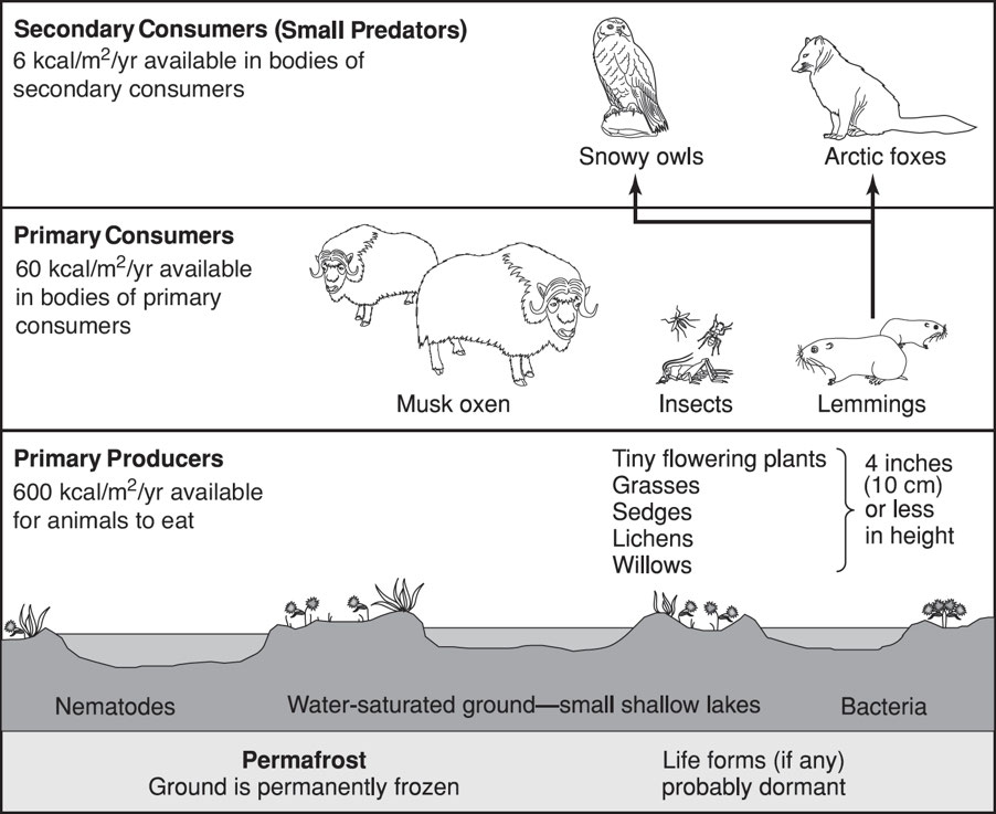
Tundra
- Tundra: It has extremely low temperatures, large repetitive population changes, limited soil nutrients, little precipitation, low biotic diversity, poor drainage, short growing and reproductive seasons, and simple vegetation structure.
- Due to the Arctic tundra's unique conditions, the biota is highly specialized and sensitive to environmental change.
- Dead organic material functions as a nutrient pool in the tundra.
Arctic Tundra
- Arctic tundra: It circles the North Pole and extends south to the taiga, is cold, dry, and desert-like.
- Organic matter and pollutants decompose slowly in cold, dry conditions.
- The very short growing season averages around 50 days per year.
- This biome survives because summer temperatures range from 37°F to 54°F (3°C to 12°C) and winter temperatures average –30°F (–34°C).
- Yearly precipitation, including melting snow, is 6 to 10 inches (15 to 25 cm).
- The thin, shallow, easily compacted, nutrient-poor soil forms slowly.
- Permafrost: A layer of permanently frozen subsoil.
- Bogs and ponds form when water saturates the upper surface, providing moisture for cold-resistant plants like low shrubs, mosses, grasses, approximately 400 flower varieties, and lichen.
- All plants are adapted to sweeping winds and disturbances of the soil.
- Short, clumped plants survive winter snowfall.
- They can photosynthesize in low light and temperatures.
- Most plants reproduce by budding and division, not by flowering.
- Food webs are simple and characterized by low biodiversity.
- Animals are highly specialized for long, cold winters and quick breeding and raising young in summer.
- Mammals and birds also have additional insulation from fat.
- Due to the scarcity of food in the winter, a lot of animals hibernate or move south.
- Animals:
- Herbivorous mammals include lemmings, caribou, Arctic hares, and squirrels.
- Carnivorous animals include Arctic foxes, wolves, and polar bears.
- Migratory birds include ravens, falcons, terns, snowbirds, and various species of gull. Insects include mosquitoes, flies, moths, grasshoppers, and bees.
- Reptiles and amphibians are few or absent.
- Fish include cod, salmon, and trout.
Alpine Tundra
Alpine tundra: It is located on mountains throughout the world at high altitudes where trees cannot grow.
- The growing season is approximately 180 days, with nighttime temperatures usually falling below freezing.
- The soil in the alpine tundra is well-drained.
Plants are very similar to those of the Arctic tundra and include grasses, dwarf trees, and small-leafed shrubs.
Animals living in the alpine tundra include mountain goats, sheep, elk, birds, beetles, grasshoppers, and butterflies.
1.3: Aquatic Biomes
- Antarctic, marine, lakes, wetlands, and rivers and streams comprise aquatic biomes.
- Aquatic organisms get nutrients from water.
- Water allows for the effective dispersal of gametes and larvae to new areas.
- Water's thermal capacity is high, most aquatic organisms don't need to regulate temperature.
- Water buoyancy reduces the need for legs and trunks.
- Water screens out UV radiation.
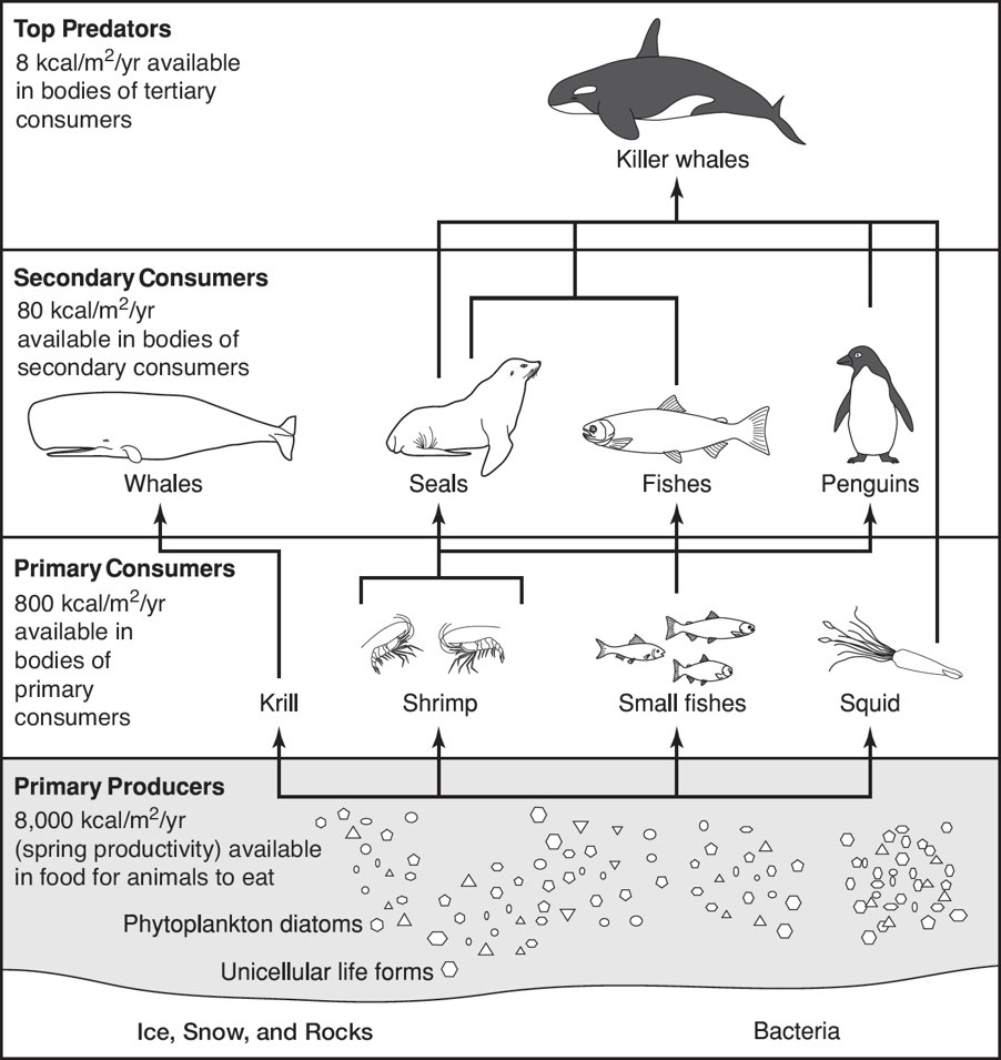
Antarctic
Antarctica has the %%coldest climate on Earth%%.
The interior averages −70°F (−57°C), while the coast averages 14°F (−10°C).
Antarctica's total precipitation (mostly snow) averages ~6.5 inches (166 mm) per year, with deserts in the interior receiving less than 10 inches (~250 mm).
Rainfall is rare and usually occurs in coastal and island areas during summer.
Antarctica's dry air and low temperatures reduce humidity.
The ice sheet is formed from compressed snow that rarely melts.
Winters are dark, cold, and phytoplankton-free.
Antarctic seas are productive because summer phytoplankton grows abundantly.
- This massive primary-producer population supports large populations of krill.
- Krill: These are key food sources in this ecosystem and serve as food for many predators.
Marine
- Oceans cover approximately 75% of Earth’s surface and have a salt concentration of about 3%.
- Evaporation of seawater is the primary source of most of the world’s rainfall.
- Ocean temperatures affect cloud cover, surface temperature, and wind patterns.
- Marine algae and photosynthetic bacteria absorb carbon dioxide and produce oxygen in the oceans.
- Oceans have the highest net primary productivity per unit area of Earth.
Ocean Circulation
- Land dominates the Northern Hemisphere and oceans the Southern.
- Summer and winter air temperature differences are greater in the Northern Hemisphere.
- Air and oceanic currents carry heat from the equator to the poles.
- Convection: The circular motion that occurs when warmer air or liquid rises, while the cooler air or liquid sinks.
- Wind patterns caused by tropical air flowing to the polar regions drive surface ocean currents.
- Temperature and density control deep-water, density-driven currents.
- Deeper ocean waters are colder and denser than near-surface waters.
- In the Northern Hemisphere, north-flowing ocean currents from the equator are warmer than south-flowing ones.
- Thermohaline currents drive a conveyor belt of ocean water that moves constantly, unlike most surface currents, which are driven by winds.
- Cold, salty water sinks, while warmer water rises.
- The Gulf Stream heats northern latitudes by entering the Norwegian Sea.
- This water sinks because it loses heat and becomes cooler and denser.
- Cold bottom water flows south to Antarctica and warms and rises to the surface in the Pacific and Indian Oceans.
Ocean Zones
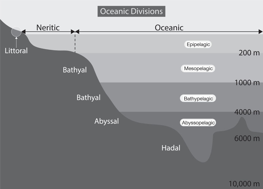
Littoral Zone: Also known as the intertidal zone, it is the part of the ocean that is closest to the shore.
Neretic Zone: Also known as the sublittoral zone, this zone extends to the edge of the continental shelf.
Photic Zone: The uppermost layer of water in a lake or ocean that is exposed to sunlight down to the depth where 1% of surface sunlight is available.
- The layer just above the depth where the rate of carbon dioxide uptake by plants is equal to the rate of carbon dioxide production by animals.
Corals
- Corals: These are marine invertebrates that typically live in compact colonies of many identical individual polyps.
- Polyps: Small, sac-like animals with a set of tentacles surrounding a central mouth opening and an exoskeleton made of calcium carbonate at the base.
- Most corals obtain the majority of their energy and nutrients from %%photosynthetic unicellular%% dinoflagellates, commonly known as zooxanthellae, that live within their tissues.
Types of Coral Reefs
- Fringing reefs
- They grow near the coastline around islands and continents and are separated from the shore by narrow, shallow lagoons.
- They are the most common type of reef.
- Barrier reefs
- These are also parallel to the coastline but are separated by deeper, wider lagoons.
- At their shallowest point, they can reach the water’s surface, forming a “barrier” to navigation.
- Atolls
- These are rings of coral that create protected lagoons and are usually located in the middle of the sea.
- They usually form when islands, often the tops of underwater volcanoes, surrounded by fringing reefs, sink into the sea, or the sea level rises around them.
Lakes
- Lakes: These are large natural bodies of standing freshwater formed when precipitation, runoff, or groundwater seepage fills depressions in Earth’s surface.
- Most lakes on Earth are located in the Northern Hemisphere at higher latitudes.
- Processes that form lakes include the following:
- Advance and retreat of glaciers that scrape depressions in Earth’s surface where water can accumulate.
- Crater lakes formed in volcanic craters and calderas.
- Oxbow lakes formed by erosion in river valleys.
- Salt or saline lakes that form where there is no natural outlet or where the water evaporates rapidly.
- Tectonic uplift of a mountain range that creates a depression that accumulates water.
- Lake Inputs include:
- Manmade sources from outside the catchment area
- Precipitation
- Runoff is carried by streams and channels from the lake’s catchment area, groundwater channels, and aquifers.
- Lake Outputs include:
- Evaporation
- Extraction of water by humans
- Surface waters and groundwater flow.
- Artificial lakes: These are constructed for hydroelectric power generation, recreational purposes, industrial and agricultural use, and/or domestic water supply.
- The depth to which light can reach in lakes depends on %%turbidity or the amount and type of suspended particles in the water%%.
- The material at the bottom of a lake can be composed of a wide variety of
- inorganic materials, such as silt or sand, and/or
- organic materials, such as decaying plant or animal matter.
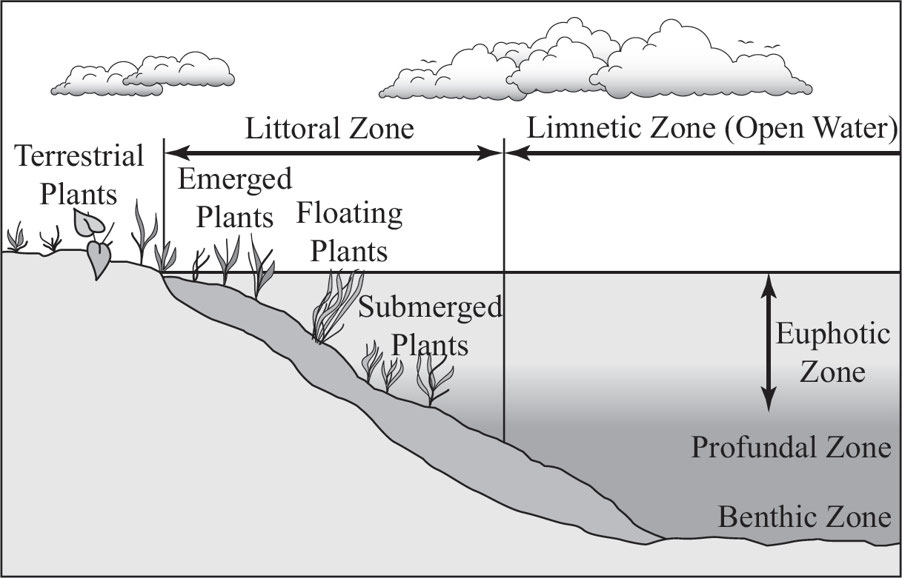
Lake Zones
Benthic Zone: The bottom of lake, organisms can tolerate cool temperatures and low oxygen levels.
Limnetic Zone: A well-lit, open surface water, farther from shore, extends to a depth penetrated by light, occupied by phytoplankton, zooplankton, and higher animals; produces food and oxygen that supports most of a lake’s consumers
Littoral Zone: It is shallow, close to shore, extends to depth penetrated by light; rooted and floating plants flourish
Profundal Zone: It is deep, no-light regions, too dark for photosynthesis; low oxygen levels; inhabited by fish adapted to cool, dark waters
Types of Lakes
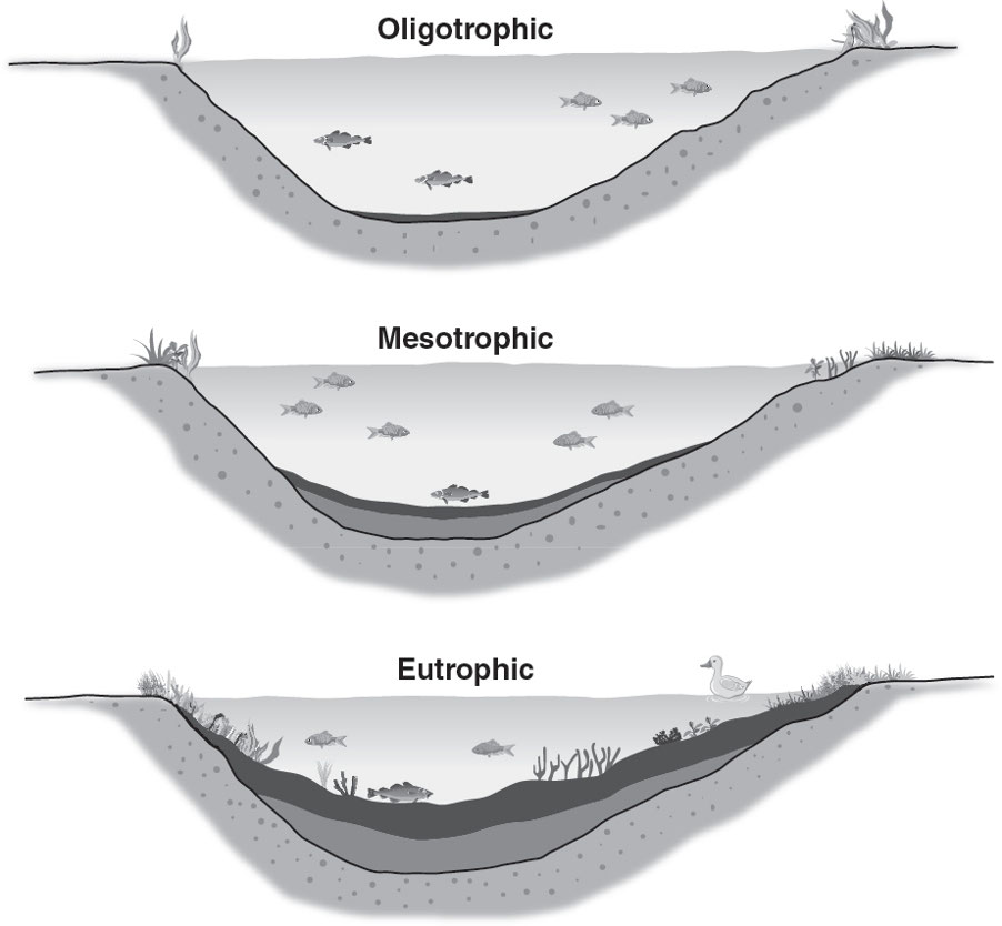
Oligotrophic (Young Lake): Deep, cold, small surface area relative to depth; nutrient-poor, phytoplankton are sparse; not very productive; doesn’t contain much life; waters often very clear; and sediments are low in decomposable organic matter.
Mesotrophic (Middle-Aged Lake): Moderate nutrient content and moderate amounts of phytoplankton; reasonably productive.
Eutrophic (Old Lake): Shallow, warm, large surface area relative to depth;
- Nutrient-rich, phytoplankton more plentiful and productive;
- Waters often murky;
- High organic matter content in benthos, which leads to high decomposition rates and potentially low oxygen.
- Eutrophication occurs over long periods of time as runoff brings in nutrients and silt.
- Pollution from fertilizers often causes algae populations to dramatically increase causing a decrease in the oxygen content of the water, with detrimental consequences for life in the lake.
Lake Stratification
- The stratification or layering of water in lakes is the result of density changes caused by shifts in temperature.
- The %%density of water increases as temperature decreases until it reaches its maximum density%% at about 39°F (4°C), causing thermal stratification—the tendency of deep lakes to form distinct layers in the summer months.
- Deep water is %%insulated from the sun and stays cool and denser%%, forming a lower layer called the hypolimnion.
- The surface and water near the shore are warmed by the sun, making them less dense, so that they form a surface layer called the epilimnion.
Seasonal Turnover
- Seasonal turnover: Refers to the exchange of surface and bottom water in a lake or pond that happens twice a year.
- During the summer, the sun heats water near the surface of lakes, which results in a %%well-defined warm layer of water occurring over a cooler one%%.
- As summer progresses, %%temperature differences increase between the layers, and a thin middle layer, or thermocline, develops%%, where a rapid transition in temperature occurs.
- Fall Turnover
- With the arrival of fall and cooler air temperatures, %%water at the surface of a lake begins to cool and becomes heavier%%.
- During this time, %%strong fall winds move the surface water around%%, which promotes mixing with deeper water.
- As the winter approaches in areas where %%subfreezing temperatures are common, the lake surface temperatures approach the freezing mark%%.
- Thus, as lake waters move toward freezing and reach 4°C, the water sinks to the lake bottom.
- Colder water remains above, potentially becoming capped by an ice layer, which further prevents the winds from stirring the water mass.
- Spring Turnover
- With spring, the %%surface ice begins to melt, and cold surface waters warm until they reach the temperature of the bottom waters%%, again producing a fairly uniform temperature distribution throughout the lake.
- When this occurs, w%%inds blowing over the lake again set up a full circulation system%%.
Wetlands
- Wetlands: These are areas that are covered with water at some point in the year and that support aquatic plants.
- High plant productivity supports a rich diversity of animal life.
- The water found in wetlands can be saltwater, freshwater, or brackish
Ecological Services of Wetlands
- Absorbing excess water from flooding or storm surges.
- Acting as carbon sinks.
- As sediment flows through a wetland from the surrounding watershed, it becomes trapped, reducing the siltation into lakes, rivers, and streams.
- Providing areas for agriculture and timber
- Providing recreational trees.
- Recharging groundwater.
- Serving as nurseries for fishes and shellfishes.
Anthropogenic Causes of Wetland Degradation
- Agriculture
- Wetlands have been drained to utilize the rich organic soil.
- Wetlands are drained by digging ditches.
- This lowers the water table and dries out the wetland.
- Consequences include salinization and soil compaction.
- Commercial Fishing
- The depletion of native species of fish and shellfish affects the wetland food webs.
- It may hurt marine life, habitats, and human communities that depend on ocean for survival.
- Dams and levees
- Dams and levees block nutrient-rich sediments from entering the floodplain, harming wetlands' food webs.
- Dam sediments prevent them from replenishing barrier islands and beach sediments.
- Development
- Draining wetlands destroys habitats, causing bank erosion and pollution.
- Dredging streams lowers the water table and dries nearby wetlands.
- Water is diverted around wetlands, lowering the water table and increasing anthropogenic pollution.
- Freshwater is depleted from wetlands for residential and commercial purposes.
- Grazing
- Compaction, vegetation loss, and streambank destabilization result.
- Wetland vegetation removes water through evapotranspiration, alters water and soil chemistry, provides wildlife habitats, and reduces erosion.
- Vegetation removal can permanently alter wetland function.
- Invasive species
- Native species cannot always compete with introduced species.
- Common invasive species traits include:
- fast growth,
- rapid reproduction,
- high dispersal ability,
- tolerance of a wide range of environmental conditions,
- ability to live off of a wide range of food types,
- association with humans, and
- prior successful invasions.
- Logging
- Logging decreases biodiversity in wetlands as natural habitats are destroyed.
- It can increase flooding.
- Mining
- Mine wastes are often deposited in the floodplain.
- It eliminates the water source of wetlands through land fractures.
- Oil exploration and spills
- Oil exploration and spills cause a disruption in wildlife both on land and in the sea.
- It causes pollution and erosion as part of the drilling process.
- Pumping groundwater
- Pumping large quantities of water from springs lowers nearby groundwater.
- It can result in the loss of wetland vegetation.
- Recreation
- Boating, all-terrain vehicles, etc., disturb sediments.
- It affects breeding grounds for fish and other wildlife and also produces noise pollution, which affects wildlife behavior.
- Roads and Railroads
- Roads and railroads narrow the floodplain, increase flooding, and create low-quality wetlands upslope of the roads by interrupting surface water and groundwater flows, which reduces sediment renewal and depletes nutrients for native vegetation and higher trophic levels.
- Lack of sediment renewal also affects fish nurseries and bird breeding grounds.
- Dumping fill material buries hydric soil, which is permanently or seasonally saturated by water, resulting in anaerobic conditions, and lowers the water table so that water-loving plants cannot compete with upland plants.
Rivers and Streams
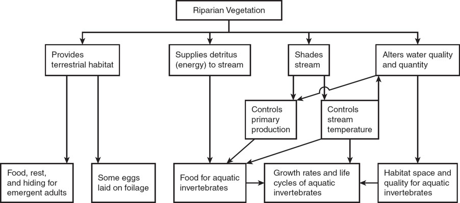
- The nutrient content of rivers and streams is largely determined by the %%terrain and vegetation of the area through which they flow%% and is also determined by %%adjacent and overhanging vegetation, the weathering of rocks in the area, and soil erosion%%.
- Rivers and streams move continuously in a single downhill direction, and their inputs include
- groundwater recharge;
- precipitation;
- springs;
- surface runoff; and
- the release of stored water in ice and snowpack.
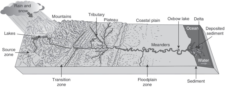
River Zones
Source Zone
- Contains headwaters or headwater streams and often begins as springs or snowmelt of cold, clear water with little sediment and relatively few nutrients.
- Narrow rocky channels, creating swift currents.
- The water has relatively high oxygen levels and may include freshwater species such as trout.
Transition Zone
- Contains slower, warmer, wider, and lower-elevation moving streams, which eventually join to form tributaries.
- The water is less clear as it contains more sediment and nutrients, with the substrate beginning to accumulate silt.
- Species diversity is usually greater than in the source zone.
Floodplain Zone
- As a result of large amounts of sediment and nutrients, the water is murky and warmer.
- Tributaries join to form rivers, which empty into oceans at estuaries.
Riparian Areas
Riparian areas: These are lands adjacent to creeks, lakes, rivers, and streams that support vegetation dependent upon free water in the soil.
Vegetation consists of hydrophilic (water-loving) plants and trees.
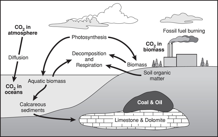
1.4: Carbon Cycle
- Carbon: It is exchanged among the biosphere, geosphere, hydrosphere, and atmosphere and is the basic building block of life and the fundamental element found in carbohydrates, fats, proteins, and nucleic acids.
- It is also found in carbon dioxide, which makes up less than 1% of the atmosphere.
- Carbon can precipitate into the ocean's deeper, more carbon-rich layers as dead soft tissue or calcium carbonate in shells.
- Carbon enters the ocean mostly by %%dissolving atmospheric carbon dioxide%%.
- One-third of soil carbon is stored in organic form.
- The creation of coral reefs and the viability of externally fertilized egg cells are %%disrupted by ocean acidification%% caused by carbon dioxide absorption.
- Due to rising CO2 concentrations, oceanic acidity may slow the natural precipitation of calcium carbonate, reducing the ocean's capacity to absorb CO2.
- The major reservoirs or “sinks” of carbon include the following:
- Plant Matter: A portion of atmospheric carbon (~15%) is removed through photosynthesis.
- Terrestrial Biosphere: Forests store about 90% of the planet’s above-ground carbon and about 75% of the planet’s soil carbon.
- Old-growth forests, limestone (CaCO3), and peat store carbon long-term.
- Oceans: The carbon in carbon dioxide dissolved in seawater is utilized by phytoplankton and kelp for photosynthesis.
- Marine organisms also require carbon for the production of shells, skeletons, and coral.
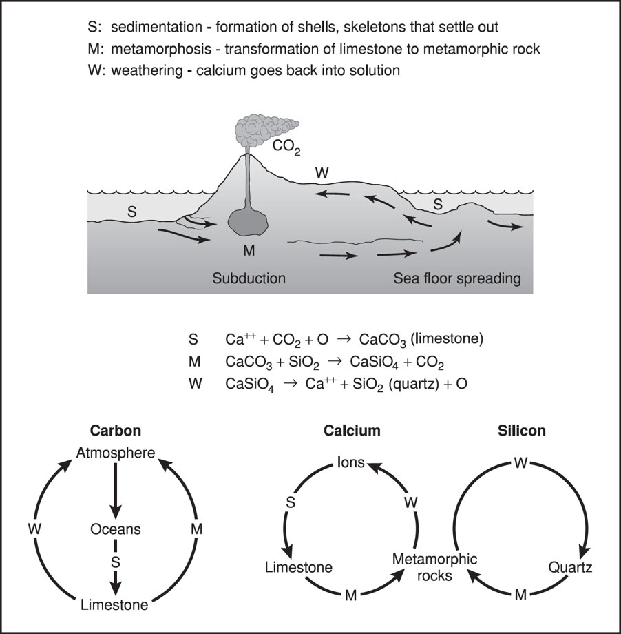
- Sedimentary Deposits: Limestone (CaCO3) is the largest reservoir of carbon in the carbon cycle.
- The calcium comes from the weathering of calcium-silicate rocks, which causes the silicon in the rocks to combine with oxygen to form sand or quartz, %%leaving calcium ions available to form limestone%%.
- Carbon is released back into the atmosphere through the following:
- Burning fossil fuels
- Cellular respiration of plants and animals break down glucose into carbon dioxide and water.
- Decay of organic material by the action of decomposers.
- Incineration of wastes
- Release of carbon dioxide by warmer ocean waters.
- Strip mining and deep plowing
- Volcanic eruptions
- Weatherization of rocks.
- When oxygen is not present, anaerobic respiration occurs and releases carbon into the atmosphere in the form of methane.
Carbon Sinks
| Carbon Sink | Amount (Billions of Metric Tons) |
|---|---|
| Marine Sediments and Sedimentary Rocks | ~75,000,000 |
| Oceans | ~40,000 |
| Fossil fuel deposits | ~4,000 |
| Soil organic matter | ~1,500 |
| Atmosphere | ~578 to 766 |
| Terrestrial plants | ~580 |
Human Impact on the Carbon Cycle
Before the Industrial Revolution, CO2 transfer rates through photosynthesis, cellular respiration, and fossil fuel burning were balanced.
After the Industrial Revolution, the deforestation of old-growth forests and the combustion of fossil fuels released carbon stored in long-term carbon sinks, causing climate change and the following environmental impacts:
- increased acidity of oceans
- increase in atmospheric particulate matter
- increased rate of melting of long-term water storage
- stronger and more frequent storm events
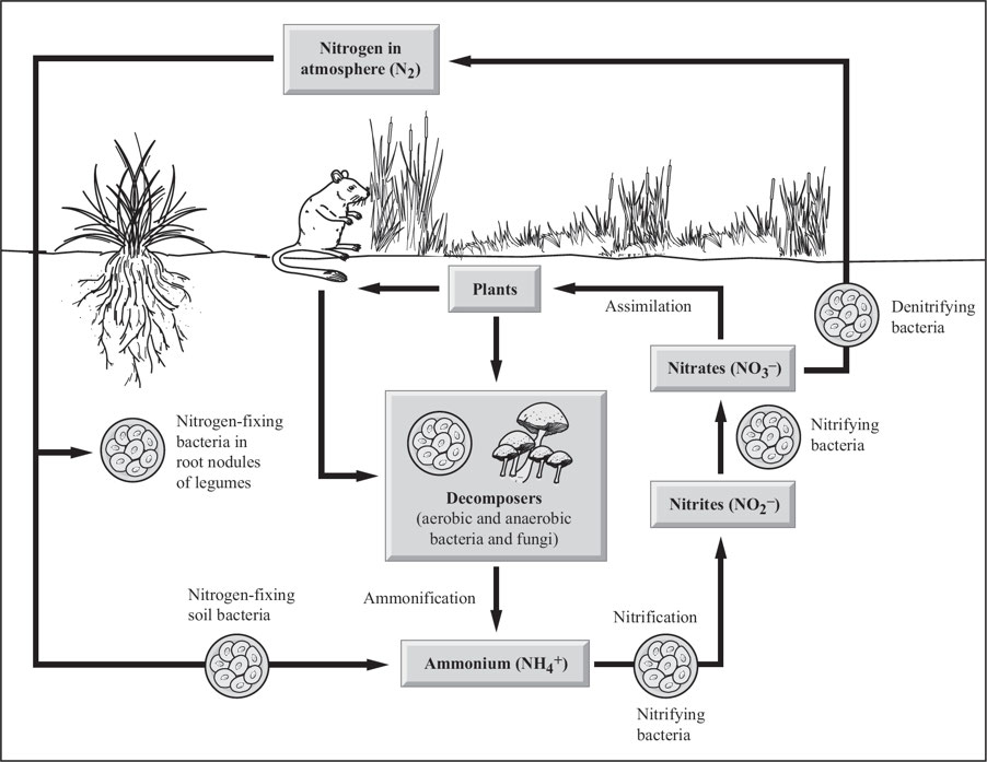
1.5: Nitrogen Cycle
- Nitrogen makes up 78% of the atmosphere.
- It is an essential element needed to make amino acids, proteins, and nucleic acids.
- Other nitrogen stores include the organic matter in the soil and the oceans.
- Though atmospheric nitrogen (N2) is abundant, it has limited use biologically, which leads to a %%scarcity of usable forms of nitrogen%% in terrestrial and aquatic ecosystems.
- Fossil fuel combustion, inorganic fertilizer use, and wastewater and sewage production have drastically altered the nitrogen cycle.
- Nitrogen %%increases water acidification, eutrophication, and toxicity%%.
- It is needed for photosynthesis and plant growth in chlorophyll.
- It’s availability %%affects primary production and decomposition%%.
- Nitrogen is a %%key component in nucleic acids (DNA and RNA) and proteins%%.
- It is a limiting nutrient in terrestrial ecosystems, so its presence %%often limits food production%%.
- The natural cycling of nitrogen, in which atmospheric nitrogen is converted to nitrogen oxides by lightning and deposited in the soil by rain, where it is assimilated by plants and either eaten by animals or decomposed back to elemental nitrogen by bacteria, includes the following processes:
- Nitrogen Fixation: Atmospheric nitrogen is converted into ammonia (NH3) or nitrate ions (NO3–), which are biologically usable forms of nitrogen.
- The key participants in nitrogen fixation are legumes, such as alfalfa, clover, and soybeans, and nitrogen-fixing bacteria known as Rhizobium.
- Nitrification: Ammonia (NH3) is converted to nitrite (NO2–) and nitrate (NO3–), which are the most useful forms of nitrogen to plants.
- Assimilation: Plants absorb ammonia (NH3), ammonium ions (NH4+), and nitrate ions (NO3–) through their roots.
- Ammonification: Decomposing bacteria convert dead organisms and wastes, which include nitrates, uric acid, proteins, and nucleic acids, to ammonia (NH3) and ammonium ions (NH4+)—biologically useful forms.
- Denitrification: Anaerobic bacteria convert ammonia into nitrites (NO2–), nitrates (NO3–), nitrogen gas (N2), and nitrous oxide (N2O) to continue the cycle.
Effects of Excess Nitrogen
Fossil fuel combustion has sevenfold increased atmospheric nitrogen oxides (NOx), particularly nitrogen dioxide.
- NOx produces tropospheric ozone, smog, acid rain, and nitrogen inputs to ecosystems.
Ammonia (NH3) in the atmosphere has tripled as a result of human activities since the Industrial Revolution.
- Ammonia acts as an aerosol and decreases air quality.
Nitrous oxide (N2O): This greenhouse gas breaks down and destroys atmospheric ozone in the stratosphere.
- N2O is in a large part emitted during nitrification and denitrification processes that take place in the soil.
- Nitrification: Reduced nitrogen compounds are sequentially oxidized to nitrite and nitrate.
- Denitrification: Reducing nitrate and nitrite to gaseous forms of nitrogen.
- In agriculture, nitrogen-containing fertilizer emits the most N2O.
Human activity has more than doubled the annual transfer of nitrogen into biologically available forms through:
- biomass burning;
- cattle and feedlots;
- extensive cultivation of legumes;
- industrial processes; and
- the extensive use of chemical fertilizers and pollution emitted by vehicles and industrial plants (NOx)
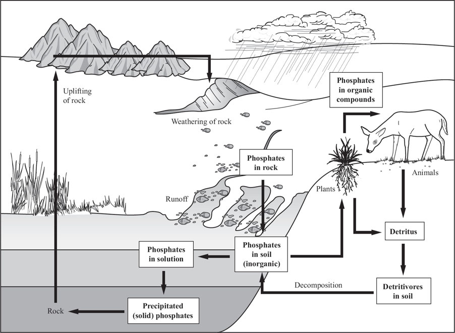
1.6: The Phosphorous Cycle
Phosphorus is essential for the production of nucleotides, ATP, fats in cell membranes, bones, teeth, and shells.
Phosphorus is not found in the atmosphere; rather, the primary sink for phosphorus is in sedimentary rocks.
- It is found in the form of the phosphate ion or the hydrogen phosphate ion.
- It is %%slowly released from terrestrial rocks by weathering%% and the %%action of acid rain%% and then dissolves into the soil and is taken up by plants.
- It is often a %%limiting factor for soils due to its low concentration and solubility%%, and it is a key element in fertilizer.
Humans have impacted the phosphorus cycle in several ways, as follows:
- Allowing runoff from feedlots, fertilizers, and municipal sewage plants to collect in lakes, streams, and ponds increases cyanobacteria, green algae, and aquatic plants.
- This growth results in decreased oxygen content in the water, which then kills other aquatic organisms in the food web.
- Applying phosphate-rich guano and other fertilizers containing phosphate to fields.
- Clearing tropical habitats for farming, which reduces the amount of phosphorus that is readily available because it is contained in the vegetation.
- Large-scale phosphorus-rich rock mining for inorganic fertilizers and detergents.
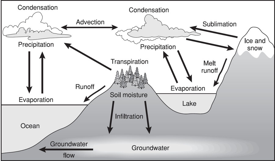
1.7: The Hydrologic Cycle
Water cycle: It is powered by energy from the sun, which evaporates water from oceans, lakes, rivers, streams, soil, and vegetation.
The oceans hold 97% of all water on the planet and are the source of 78% of all global precipitation.
Oceans are also the source of 86% of all global evaporation, %%with evaporation from the sea surface keeping Earth from overheating%%.
The water cycle is in a state of dynamic equilibrium by which the rate of evaporation equals the rate of precipitation.
- Warm air holds more water vapor than cold air.
Processes involved in the water cycle include the following:
- Condensation: The conversion of a vapor or gas to a liquid
- Evaporation: The process of turning from a liquid into vapor
- Evapotranspiration: The process by which water is transferred from the land to the atmosphere by evaporation from the soil and other surfaces and by transpiration from plants
- Infiltration: The process by which water on the ground surface enters the soil
- Precipitation: Rain, snow, sleet, or hail that falls to the ground
- Runoff: Part of the water cycle that flows over land as surface water instead of being absorbed into groundwater or evaporating
Human Impact on Water Cycle
| Human Activity | Impact on Water Cycle |
|---|---|
| Agriculture | Runoff contains nitrates, phosphates, ammonia, etc. |
| Building power plants | Increased thermal pollution |
| Clearing of land for agriculture and urbanization | Accelerated soil erosion; Decreased infiltration; Increased flood risks; Increased runoff. |
| Destruction of wetlands | Disturbing natural processes that purify water |
| Pollution of water sources | Increased occurrences of infectious agents such as cholera, dysentery, etc. |
| Sewage runoff, feedlot runoff | Cultural eutrophication |
| Withdrawing water from lakes, aquifers, and rivers | Groundwater depletion and saltwater intrusion |
Water Distribution
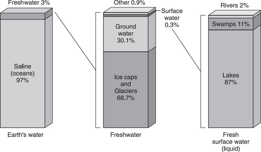
Over 70% of Earth’s surface is covered by water, with oceans holding about 97% of all water on Earth, and freshwater making up only about 3%.
Of the freshwater that is available, most of it is trapped in glaciers and ice caps, with the rest found in groundwater, lakes, soil moisture, atmospheric moisture, rivers, and streams.
Water Properties
- A %%lot of energy%% is needed to evaporate water.
- %%Strong hydrogen bonds%% hold water molecules together.
- The temperature of water changes slowly due to its %%high specific heat capacity%%.
- Water expands when it freezes.
- Water %%filters out harmful UV radiation%% in aquatic ecosystems.
- Water has a high boiling point.
- Water is a polar molecule, which means the following:
- Capillary action: A result of hydrogen bonding, helps tree roots take up water, allowing trees to grow as large as they do.
- Floating ice: Essential to life near the poles, results from the different ways water molecules arrange themselves at different temperatures.
- The polarity of water helps to dissolve many compounds.
- Water’s polarity allows interaction with non-polar molecules.
Freshwater
- The renewal of Earth’s freshwater supply %%depends on the regular movement of water from Earth’s surface into the atmosphere and back again%%.
Freshwater Renewal Rates
| Source of H2O | Average Renewal Rate |
|---|---|
| Groundwater (deep) | ~10,000 years |
| Groundwater (near the surface) | ~200 years |
| Lakes | ~100 years |
| Glaciers | ~40 years |
| Water in the soil | ~70 days |
| Rivers | ~16 days |
| Atmosphere | ~8 days |
Aquifers
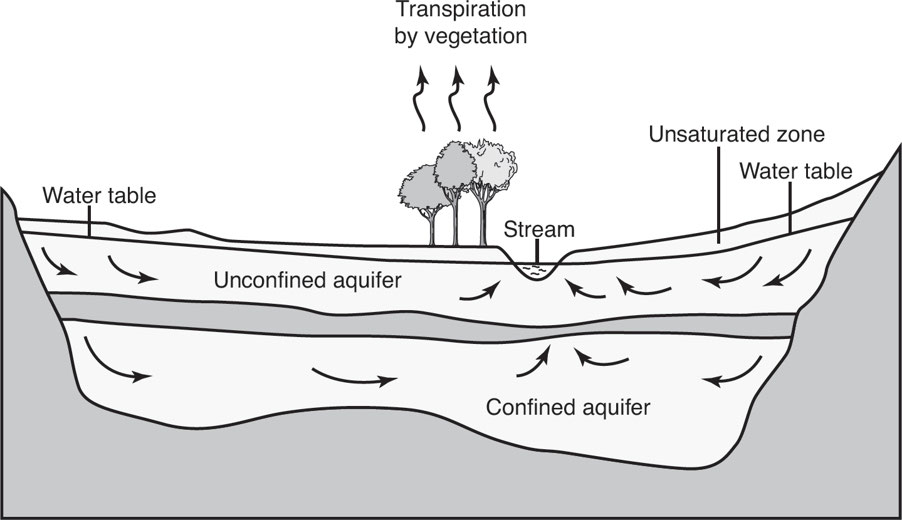
Aquifer: A geologic formation that contains water in quantities sufficient to support a well or spring.
Confined “artesian well” aquifer: An aquifer below the land surface that is saturated with water.
- As a result of impermeable material above and below the aquifer, the water is under pressure.
Recharge zone: The surface area above an aquifer that supplies water to the aquifer.
Unsaturated zone: The zone immediately below the land surface where the open spaces in the soil contain both water and air, but are not totally saturated with water.
Water table: The level below which the ground is saturated with water.
Factors that Threaten Aquifers
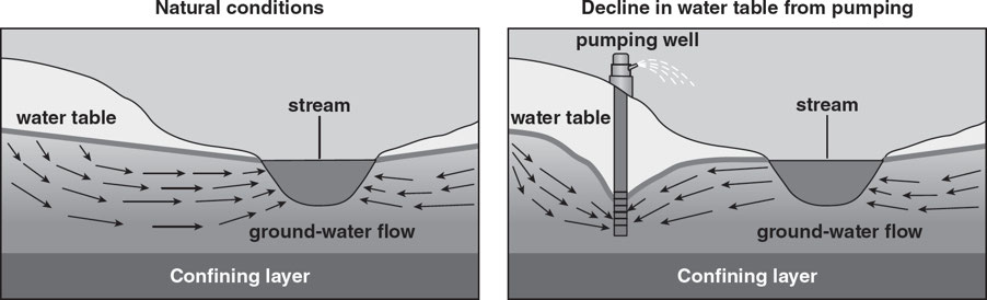
- Aquifer depletion is primarily caused by sustained groundwater pumping.
- When the rate of groundwater extraction is greater than the rate of aquifer recharge, the %%net effect is a drop in the water table%%.
- Though agriculture is the largest sector responsible for aquifer depletion, %%domestic and municipal withdrawals%% also affect groundwater levels in many areas around the world.
- %%As human populations increase, the rates of groundwater extraction likewise increase.%%
- Changes in global weather patterns also %%reduce aquifer inputs, jeopardizing groundwater levels.%%
Effects of Groundwater Depletion
Increased costs as more energy is required for pumping
Land subsidence: The sinking of land that results from groundwater extraction.
Water shortages: Since groundwater is the main water source for many populations, residents of these areas may experience water insecurity for domestic and agricultural needs.
Lowering of the water table.
Overgrazing and the resulting erosion
Reduction of water in lakes, ponds, and streams
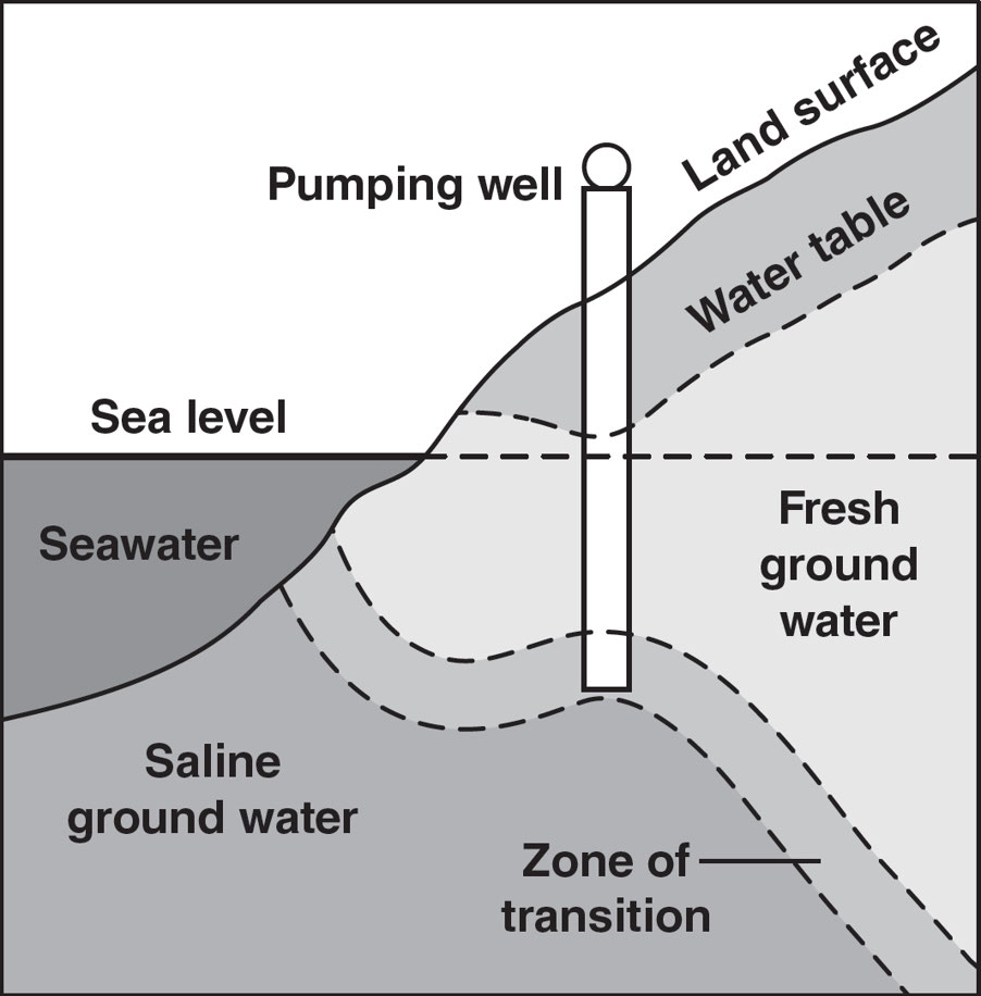
Saltwater intrusion: The movement of saltwater into freshwater aquifers, which can lead to contamination.
1.8: Primary Productivity
The ultimate source of energy is the sun.
- Plants are able to use this light energy to %%create food through the process of photosynthesis.%%
- Photosynthesis: The plants remove carbon dioxide from the atmosphere and use light energy to produce carbohydrates and other organic compounds:

Plants capture light primarily through the green pigment chlorophyll, which is contained in organelles called chloroplasts.
The energy derived from the oxidation of glucose during cellular respiration is then used to %%form other organic compounds%% such as cellulose, lipids, amino acids, and eventually proteins.
Oxygen gas is released into the atmosphere during photosynthesis, and plants emit carbon dioxide during respiration.
Since plants produce less carbon dioxide than they absorb, they, therefore, become net sinks of carbon.
Factors that affect the rate of photosynthesis include:
- carbon dioxide concentration;
- the amount of light and its wavelength;
- the availability of water; and
- temperature.
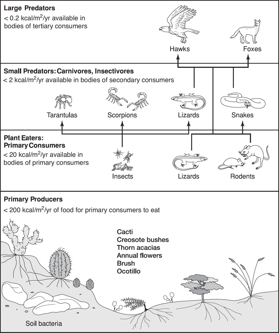
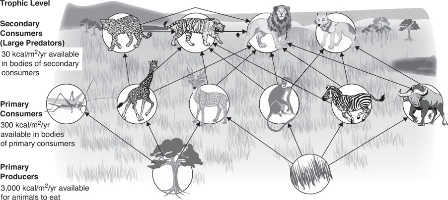
1.9: Trophic Levels
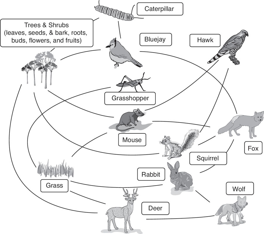
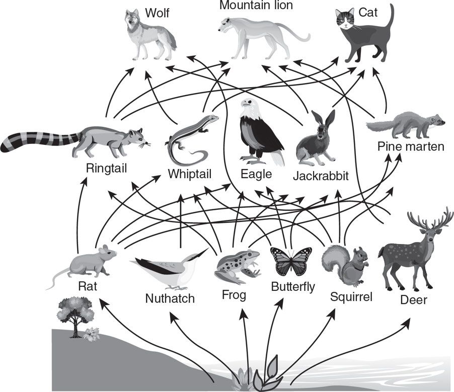
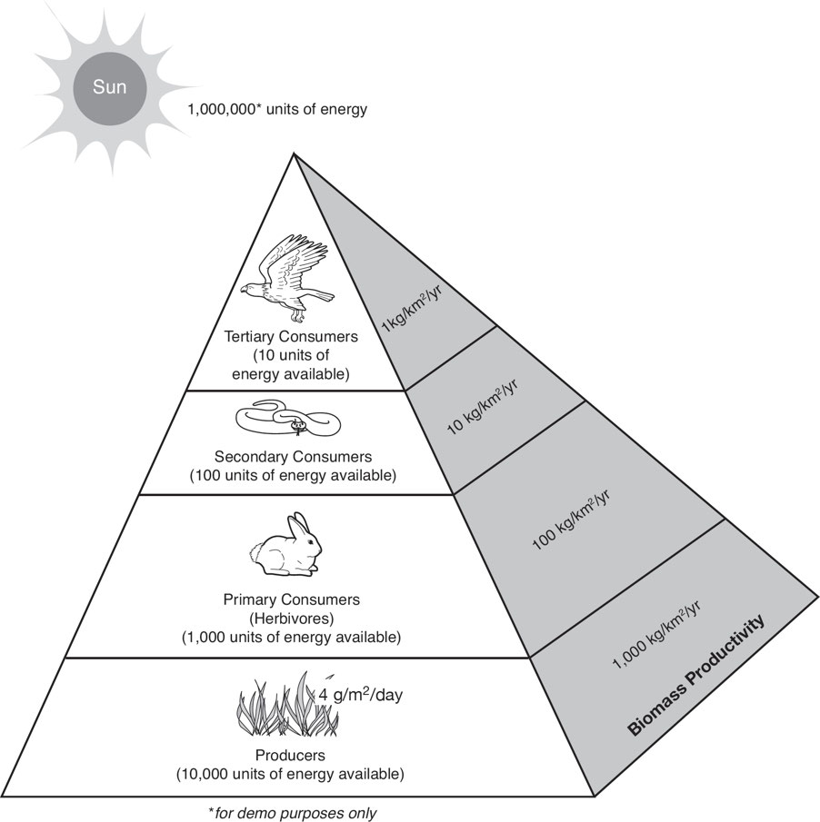
Trophic Level: The position an organism occupies in a food chain and is the number of steps it is from the start of the chain.
Food web: The natural interconnection of food chains.
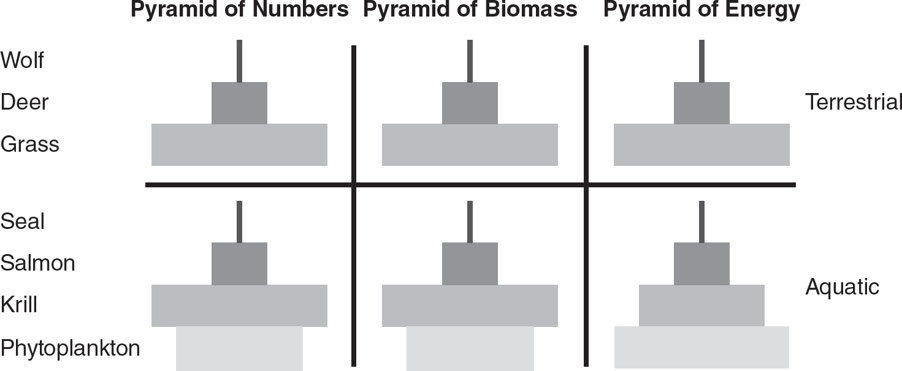
Ecological Pyramids
Ecological pyramids: These show ecosystem properties by placing primary producers at the base and decreasing energy as species move away from them.
In some instances, biomass pyramids can be inverted, and are often seen in aquatic and coral reef ecosystems.
- Zooplankton has a longer lifespan than phytoplankton, so its biomass is higher.
- One generation of zooplankton may consume several generations of phytoplankton.
- Only 10% of a generation's biomass is transferred.
Primary consumers have longer life spans and slower growth rates and accumulate more biomass than the producers they consume.
- Phytoplankton lives just a few days.
- Zooplankton eats the phytoplankton live for several weeks.
- The fish eating the zooplankton live for several years.
Aquatic predators also tend to have a %%lower death rate%% than the smaller consumers, which further contributes to the inverted pyramid pattern.
Energy pyramids will always have an upright pyramid shape if all sources of food energy are included.
- Second Law of Thermodynamics: States that as energy is transferred or transformed, more and more of it is wasted.
- Entropy: A natural tendency of any isolated system to degenerate from an ordered state into a more disordered state.
1.10: Energy Flow and the 10% Rule
Cellular Respiration
Heterotrophs: Organisms dependent on photosynthetic organisms.
Cellular respiration is the opposite of photosynthesis.
- In respiration, glucose is oxidized by the cells to produce carbon dioxide, water, and chemical energy.
- This energy is then stored in the molecule adenosine triphosphate (ATP).

Ecological Pyramids and the 10% Rule
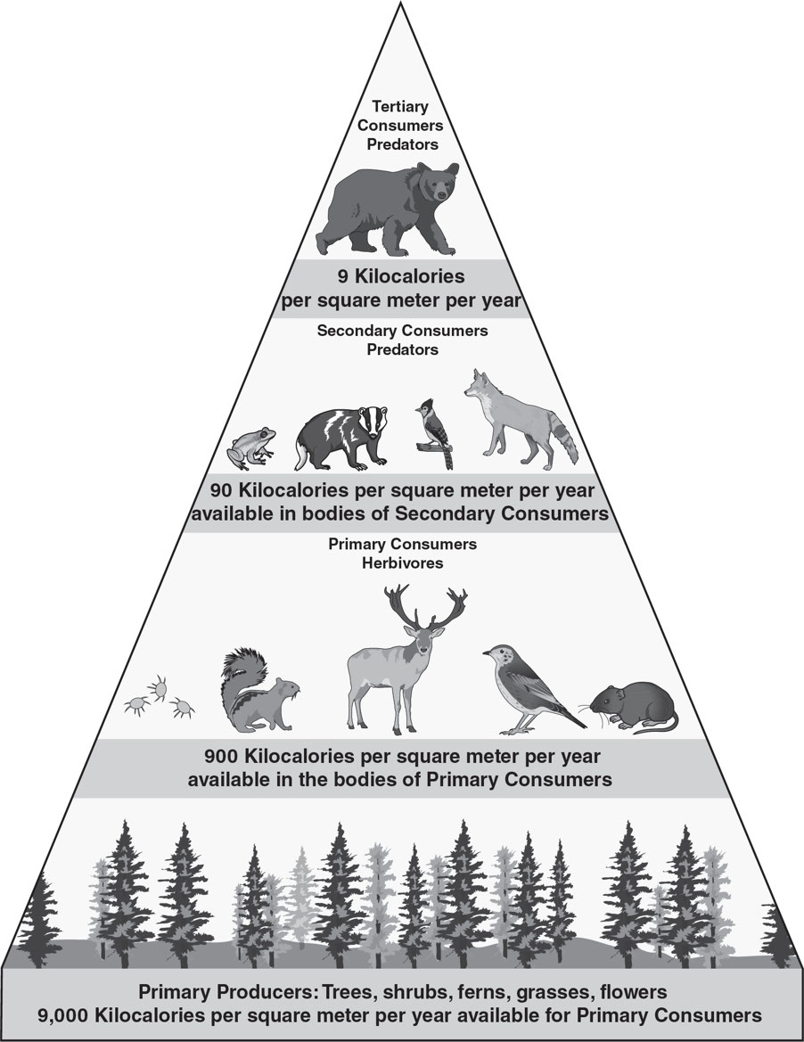
- Only about %%10% of the energy%% used to move from one trophic level to the next is used to turn organic matter into tissue.
- The remaining energy is typically lost as heat during metabolic reactions, temperature control, incomplete digestion, and waste product decay.
- Sunlight is the ultimate source of energy required for most biological processes.
- 35% of Earth's solar energy heats water, land, and evaporates water.
- 8% of solar energy is available to plants, 1% of which is used for photosynthesis. 15% is reflected back into space, and 80% is absorbed by Earth.
- 10% Rule: It states that energy is lost mostly as heat from one stage to the next.
- Productivity: Refers to the rate of generation of biomass in an ecosystem and is expressed in units of mass per unit surface area (or volume) per unit time, with mass referring to dry matter or to the mass of carbon generated.
- Productivity of autotrophs is called primary productivity.
- Productivity of heterotrophs is called secondary productivity.
- Secondary production: The generation of biomass by heterotrophic consumers in a system, is driven by the transfer of organic material between trophic levels, and represents the quantity of new tissue created through the use of assimilated food by organisms responsible for secondary production.
Biomass Pyramids
Biomass pyramid: It shows how much organic mass is within each trophic level.
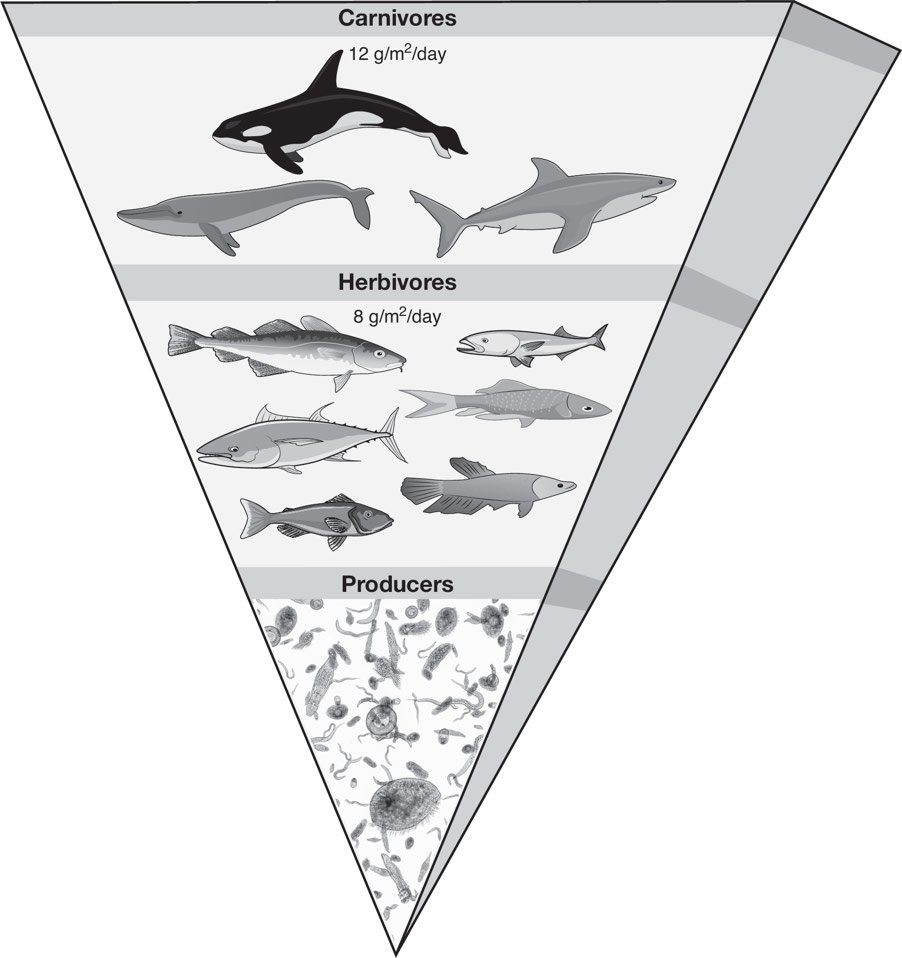
Marine pyramid of biomass is inverted because:
- trophic level biomass depends on member longevity;
- the biomass of zooplankton is greater than that of phytoplankton and predatory fish are much larger than zooplankton; and
- the producers in ocean or aquatic ecosystems are phytoplankton and have lower mass than zooplankton.
Energy Pyramids
Energy Pyramids: These show the proportion of energy passed from one trophic level to the next-level consumers in an ecosystem
- The energy temporarily “trapped” within the mass of the trophic level is not counted.
Ecosystem Productivity
- Photosynthesis uses only %%3% of Earth's sunlight for land plants and 1% for aquatic plants%%.
- Heterotrophs at all trophic levels have limited energy due to the low efficiency of solar energy conversion into carbon compound energy.
Gross Primary Production (GPP)
- Gross primary production (GPP): The rate at which plants capture and fix a given amount of chemical energy as biomass in a given length of time.
- Primary producers use some fixed energy for cellular respiration and tissue maintenance.
Net Primary Production (NPP)
Net primary production (NPP): The remaining fixed energy is the rate at which a ll the plants in an ecosystem produce net useful chemical energy.
- NPP is equal to the difference between the rate at which the plants produce useful chemical energy known as gross primary productivity (GPP) and the rate (R) at which they use some of that energy during respiration.

Open oceans collectively have the %%highest net primary productivity%%.