knowt ap exam guide logo

AP Environmental Science Unit 4 - Earth Systems

4.1 - Plate Tectonics

Earth’s Structure

  • Core:dense mass of solid nickel, iron, and radioactive elements that release massive amounts of heat

  • Mantle: liquid layer of magma surrounding the core, kept liquified by intense heat from the core

  • Asthenosphere: solid, flexible outer layer of mantle, beneath the lithosphere

  • Lithosphere: thin, brittle layer of rock floating on top of mantle (broken up into tectonic plates)

  • Crust: very outer layer of the lithosphere, the earth’s surface

Plate Boundaries

  • Divergent Plate Boundary

    • Plates move away from each other

    • Rising magma plume from the mantle forces plates apart

      • Forms: mid-oceanic ridges, volcanoes, seafloor spreading, and rift valleys (on land)

  • Convergent Plate Boundary

    • Plates move towards each other

    • Leads to subduction (one plate is forced underneath another)

      • Forms: mountains, island arcs, earthquakes, and volcanoes

  • Transform Fault Plate Boundary

    • Plates slide past each other in opposite directions

      • Forms: earthquakes

Convection Cycles (Divergent)

  • Magma heated by the earth’s core rises towards the lithosphere

  • Rising magma cools and expands, forcing oceanic plates apart

    • Creates mid-oceanic ridges, volcanoes, spreading zones or “seafloor spreading”

  • Magma cools and solidifies into new lithosphere

  • Spreading magma forces oceanic plates into continent (subduction zone)

    • Sinking oceanic plate melts back into magma

    • Also forces magma up, creating narrow, coastal mountains (Andes) and volcanoes on land

Convergent Boundary = Subduction Zone

  • Oceanic-Oceanic: one plate subducts underneath other

    • Forces magma up to lithosphere surface, forming mid-ocean volcanoes

      • Island arcs

    • Off-shore trench

  • Oceanic-Continental: dense oceanic plate subducts beneath a continental plate and melts back into magma

    • Forces magma up to the lithosphere surface

    • Coastal mountains (Andes), volcanoes on land, trenches, tsunamis

  • Continental-Continental: one plate subducts underneath the other, forcing the surface crust upward (mountains)

    • Ex. Himalayas

Transform Fault Boundary

  • Plates sliding past each other in opposite directions create a fault (fracture in rock surface)

    • Earthquakes are the most common activity

    • Occur when rough edges of plate get stuck on each other

    • Pressure builds as plates keep sliding, but edges stay stuck

    • When stress overcomes the locked fault, plates suddenly release, slide past each other, and release energy that shakes the lithosphere

Tectonic Map

  • Can predict…

    • Ring of Fire: pattern of volcanoes all around the pacific plate

      • Offshore island arcs (Japan)

    • Transform Faults: likely location of earthquakes

    • Hotspots: areas of especially hot magma rising up to the lithosphere

      • Mid-ocean islands (Iceland, Hawaii)

4.2 - Soil Formation and Erosion

What is Soil?

  • mix of geologic (rock) and organic (living) components

    • Sand, silt, clay

    • Humus: main organic part of soil (broken down biomass like leaves, dead animals, waste, etc.)

    • Nutrients: ammonium, phosphates, nitrates

    • Water and Air

    • Living organisms

  • Soil anchors the roots of plants and provides water, shelter, and nutrients (N, P, K, Mg) for growth

  • Soil filters rainwater + runoff (water) by trapping pollutants in pore spaces + plant roots. Clean water enters groundwater + aquifers

  • Nutrient Recycling:home to decomposers that break down dead organic matter + return nutrients to the soil

  • Soil provides habitats for organisms like earthworms, fungi, bacteria, moles, and slugs

Weathering and Erosion

  • Weathering

    • Breakdown of rocks into smaller pieces

      • Physical

        • wind, rain, freezing/thawing of ice

      • Biological

        • roots of trees crack rocks

      • Chemical

        • acid rain, acids from moss/lichen

    • Weathering of rocks = soil formation

      • Broken into smaller and smaller pieces

      • Carried away and deposited by erosion

  • Erosion

    • Transport of weathered rock fragments by wind and rain

    • Carried to a new location and deposited (deposition)

Soil Formation

  • From Below

    • Weathering of parent material produces smaller and smaller fragments that make up geological/inorganic part of soil

      • Sand, silt, clay

      • Minerals

  • From Above

    • Breakdown of organic matter adds humus to soil

    • Erosion deposits soil particles from other areas, adding to soil

  • Effects on Soil Formation

    • Parent Material: soil pH, nutrient content

    • Topography: steep slope = too much erosion; more level ground = deposition

    • Climate: warmer = faster breakdown of organic matter; more precipitation = more weathering, erosion + deposition

    • Organisms: soil organisms like bacteria, fungi, and worms breakdown organic matter

Soil Horizons

  • O-Horizon: layer of organic matter (plant roots, dead leaves, animal waste, etc) on top of soil

    • Provides nutrients and limits H2O lost to evaporation

  • A-Horizon: aka topsoil; layer of humus (decomposed organic matter) and minerals from parent material

    • A-Horizon has most biological activity (earthworms, soil microbes) breaking down organic matter to release nutrients

  • B-Horizon: aka subsoil; lighter layer below topsoil, mostly made of minerals with little to no organic matter

    • Contains some nutrients

  • C-Horizon: least weathered soil that is closest to the parent material, sometimes called bedrock

Soil Degradation:

  • The loss of the ability of soil to support plant growth

    • Loss of Topsoil: tiling (turning soil for agriculture) + loss of vegetation disturb soil and make it more easily eroded by wind and rain

      • loss of topsoil dries out the soil, removes nutrients + soil organisms that recycle nutrients

    • Compaction: compression of soil by machines (tractors, bulldozers, etc.), grazing livestock, and humans reduces ability to hold moisture

      • Dry soil erodes more easily

      • Dry soil supports less plant growth, less root structure, leading to more erosion

    • Nutrient Depletion: repeatedly growing crops on the same soil removes key nutrients (N, P, K, Na, Mg) over time

      • Reduces ability to grow future crops

4.3 - Soil Composition and Properties

Soil Particle Size, Texture, and Porosity

  • Geologic (rock) portion of soil is made up of 3 particles

    • (biggest to smallest) Sand > Silt > Clay

  • Soil Texture: the % of sand, silt, and clay in a soil

    • Always adds up to 100%

  • Because sand is bigger, it has bigger pores (empty spaces between particles)

    • This allows air + water to enter sandy soil easily

    • Clay has smallest pores, so it’s harder for air + water to enter clay-heavy soils

  • Porosity: the amount of pore space a soil has

    • more sand in a soil = more porous/higher porosity (easier for water + air to enter)

    • more clay in a soil = less porous/less porosity (harder for water + air to enter)

Soil Texture Chart

  • Soil texture is determined by clay, sand, and silt %

Porosity, permeability, and H2O Holding Capacity

  • Porosity: the pore space within a soil (more sand, more porous)

  • Permeability: how easily water drains through a soil

  • More porous/higher porosity = more permeable/higher permeability

    • Positive relationship between porosity and permeability

  • H2O Holding Capacity: how well water is retained or held by a soil

    • More porous/permeable = lower H2O

    • Inverse relationship between porosity/permeability and H2O holding capacity

  • Effect on Soil Fertility

    • Soil that is too sandy (too permeable) drains water too quickly for roots + dries out

    • Clay-heavy soil doesn’t let H2O drain to roots or waterlogs (suffocating them)

    • Ideal soil for most plant growth is loam, which balances porosity or drainage with H2O holding capacity

Soil Fertility

  • ability of soil to support plant growth

    • Nutrients:

      • N, P, K+, Mg2+, Ca+, Na+

      • Factors that increase soil nutrients:

        • Organic matter (releases nutrients)

        • Humus (holds and releases nutrients)

        • Decomposer activity (recycles nutrients)

        • Clay (negative charge binds positive nutrients)

        • Bases (Calcium carbonate - limestone)

      • Factors that decrease soil nutrients:

        • Acids leach positive charge nutrients

        • Excessive rain/irrigation leeches nutrients

        • Excessive farming depletes nutrients

        • Topsoil erosion

    • Water

      • Needs to hold water, but not too much

      • Factors that increase H2O holding capacity:

        • Aerated soil (biological activity)

        • Compost/humus/organic matter

        • Clay content

        • Root structure, especially natives

      • Factors that decrease H2O holding capacity:

        • Compacted soil (machines, cows)

        • Topsoil erosion

        • Sand

        • Root loss

  • Characteristics and Tests of Soil Quality

    • Texture:

      • How to test:

        • Let soil settle in a jar of water. Measure 3 layers that form (sand, silt, clay)

      • What it tells you:

        • % of sand, sild, and clay - how porous or permeable soil is

    • Permeability:

      • How to test:

        • Measure time for H2O to drain through column of soil

      • What it tells you:

        • How easily water drains through soil. Too high, soil dries out. Too low, roots don’t get water or drown. Medium = optimal

    • pH:

      • How to test:

        • pH strop - H+ ion concentration

      • What it tells you:

        • How acidic (low pH) or basic/alkaline (high pH) soil is. More acidic soil = less nutrient availability

    • Color:

      • How to test:

        • Compare with soil book color chart

      • What it tells you:

        • Darker = more humus = more nutrients and moisture

    • Nutrient Level:

      • How to test:

        • Measure ammonium, nitrate, or phosphate level

      • What it tells you:

        • Higher nutrient levels = more plant growth. Low level could indicate acidic soil, depletion

4.4 - Atmosphere

Gasses of Earth’s Atmosphere

  • Nitrogen ~ 78%

    • Mostly in the form of N2 (unuseable to plants without being fixed)

  • Argon ~ 0.93%

    • Inert, noble gas

  • CO2 ~ 0.04%

    • Most important greenhouse gas; leads to global warming

    • Removed from atmosphere by photosynthesis

  • Oxygen ~ 21%

    • Produced by photosynthesis in plants and needed for human/animal respiration

  • Water Vapor ~ 0-4%

    • Varies by region and conditions; acts as a temporary greenhouse gas, but less concerning than CO2

    • Quickly cycles through atmosphere

Characteristics of Layers

  • Exosphere: Outermost layer where the atmosphere merges with space

  • Thermosphere: Therm= hottest temp

    • absorbs harmful X-rays and UV radiation

    • charged gas molecules glow under intense solar radiation producing northern lights (aurora borealis)

  • Mesosphere: Meso = middle; 60-80 km, even less dense

  • Stratosphere: “S” for second - 16-60 km; less dense due to less pressure from layers above

    • Thickest O3 layer is found here; absorbs UV-B and UV-C rays which can mutate DNA of animals (cancer)

  • Troposphere: Tropo = change (weather occurs here) - 0-16 km, most dense due to pressure of other layers above it

    • Most of atmosphere’s gas molecules are found here

    • Ozone (O3) in the troposphere is harmful to humans (respiratory irritant) and damages plant stomata, and forms smog

Temperature Gradient

  • Layers of earth’s atmosphere are based on where temperature gradients change with distance from earth’s surface

    • Thermosphere: temperature increases due to the absorption of highly energetic solar radiation

      • Hottest place on earth (3,100 degrees Fahrenheit)

    • Mesosphere: temperature decreases because density decreases, leaving fewer molecules to absorb sun

      • Coldest place on earth (-150 degrees Fahrenheit)

    • Stratosphere: temperature increases because top layer of stratosphere is warmed by UV rays (like pool surface)

    • Troposphere: temperature decreases as air gets further from warmth of earth’s surface

4.5 - Global Wind Patterns

Air Properties

  • Warm air rises

  • Warm air holds more moisture than cold

  • Rising air expands and cools

  • Cool air can’t hold as much H2O vapor(condenses and becomes rain)

  • After cooling and expanding, air sinks

Coriolis Effect

  • Deflection of objects traveling through atmosphere due to spin of earth

  • Air at 30 degrees moves back to L pressure of equator

  • Wind between 0-30 degrees moves from East to West

    • Because earth is spinning West to East

  • Wind between 30-60 degrees moves West to East

    • Because earth spins faster at 30 degrees than 60 degrees

Global Wind Patterns

  • Air moves out from 30 degrees to 0 degrees and 60 degrees due to high pressure at 30 degrees and low pressure at 0 and 60.

    • Air rising at equator = low pressure, air sinking down at 30 degrees = high pressure

  • 0-30 degrees winds blow East to West (Eastern trade)

    • Drives ocean current clockwise in Northern hemisphere, counterclockwise in Southern hemisphere

  • 30-60 degrees winds blow West to East (Westerlies)

    • Drives weather patterns of North America

4.7 - Solar Radiation and Earth’s Seasons

Insolation: the amount of solar radiation (energy from sun’s rays) reaching an area

  • Measured in Watts/m²

Solar Intensity and Latitude
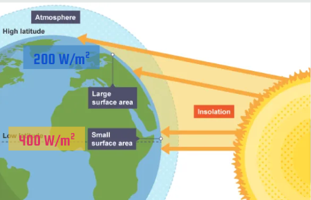
  • Solar intensity of insolation (W/m²) depends on:

    • Angle: how directly rays strike earth’s surface

    • The amount of atmosphere sun’s rays pass through

    • Equator = higher insolation than higher latitudes

Solar Intensity and Season

  • The orbit of the earth around the sun and its tilt on the axis changes the angle of the sun’s rays

    • Causes varying insolation, varying length of day, and seasons

  • Tilt of earth’s axis stays fixed during orbit

    • June and December Solstices: north or south hemisphere is maximally tilted toward sun (summer/winter)

    • March and September Equinoxes: north and south hemispheres equally facing sun

  • Tilt of earth’s axis causes variation in:

    • angle of insolation (which changes intensity)

    • length of day

    • season

Albedo

  • Albedo: the proportion of light that is reflected by a surface

  • Surfaces with higher albedo reflect more light, and absorb less (ice/snow)

    • Absorb less heat

  • Surfaces with low albedo reflect less light, and absorb more (water)

    • Absorb more heat

Albedo and Surface Temperature

  • Surface temperature is affected by albedo

  • When sunlight is absorbed by a surface, it gives off infrared radiation (heat)

    • Areas w/lower albedo, absorb more sunlight light (heat)

  • Urban Heat Island: urban areas are hotter than surrounding rural area due to low albedo of blacktop

  • Polar regions are colder due to higher albedo

4.8 - Earth’s Geography and Climate

Climate and Geography

  • Climate is largely determined by insolation (latitude → angle of insolation & atmosphere)

    • Higher latitudes receive less insolation: cooler, less precipitation (especially 30 degrees)

    • Equator receives most intense insolation: higher temp, air rises, high precipitation

  • Geography also plays a role

    • Mountains: disrupt wind & produce rain shadow effect

    • Oceans: moderate temperature & add moisture to the air

Rain Shadows

  • Warm, moist air from ocean hits the “windward” side of the mtn, rises, cools (condensing H2O vapor & causing rain) → lush, green vegetation

  • Dry air descends down “leeward” side of mtn, warming as it sinks

    • Leads to arid (dry) desert conditions

  • Ex. eastern trade winds blow moist air from Atlantic across SA

    • Windward (E) side of Andes receives heavy rainfall

    • Leeward (W) side of Andes receives arid (dry) air

    • -30 degrees latitude also contributes to lack of rain

      • high pressure, dry, descending air from Hadley cell

4.9 - El Nino and La Nina

Global Ocean Surface Currents
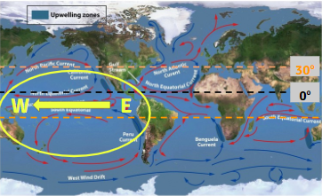
  • Gyers: large ocean circ. patterns due to global wind

    • (clockwise in N hemisphere, counterclockwise in S hemisphere)

  • E→ W trade winds between 0-30o push eq. current E → W

  • Westerlies between 30-60o push mid lat. currents W→ E

  • Upwelling Zones: areas of ocean where winds blow warm surface water away from a land mass, drawing up colder, deeper water to replace it

    • Brings O2 & nutrients to surface → productive fishing

Thermohaline Circulation

  • Connects all of the world’s oceans, mixing salt, nutrients, and temperature throughout

  • Warm water from Gulf of Mexico moves toward North Pole

  • Cools & evaporates as it moves toward poles

  • Saltier & colder water at poles, is more dense, making it sink

  • Spreads along ocean floor

  • Rises back up into shallow warm ocean current at upwelling zones

El Nino Southern Oscillation (ENSO)

  • ENSO: pattern of shifting atmospheric pressure & ocean currents in the Pacific Ocean between South America and Australia/Southeast Asia

    • Oscillates, or shifts regularly from El Nino (warmer, rannier) to La Nina (cooler, drier) conditions along coast of South America

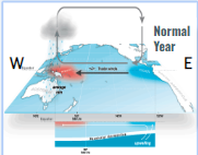
  • Normal year:

    • Trade winds blow eq. water W ← E

    • Cool H2O upwelled off coast of SA (cool temp + good fi$herie$)

    • Warm eq. current brings heat & precip. to Australia & SE Asia

    • High pressure in east pacific (SA)

    • Low pressure in west pacific (Australia & SE Asia)

  • El Nino:

    • Trade winds weaken, then reverse (W → E)

    • Warm eq. current brings heat & precip. to Americas (N & S)

    • Suppressed upwelling off SA coast (damaging fi$herie$)

    • Cooler, drier conditions in Australia & SE Asia

    • High pressure in West Pacific (Australia & SE Asia)

    • Low pressure in East Pacific (SA)

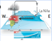
  • La Nina:

    • Stronger than normal trade winds (W ← ← ← E)

    • Increased upwelling off SA coast brings cooler than normal conditions, extra good fi$herie$

    • Warmer & rainier than normal in Australia & SE Asia

Effects of El Nino and La Nina

  • Effects of El Nino

    • Suppressed upwelling & less productive fisheries in South America

    • Warmer winter in much of North America

    • Increased precip & flooding in Americas (West coast especially)

    • Drought in South East Asia & Australia

    • Decreased hurricane activity in Atlantic ocean

    • Weakened monsoon activity in India & South East Asia

  • Effects of La Nina

    • Stronger upwelling & better fisheries in SA than normal

    • Worse tornado activity in US & Hurricane activity in Atlantic

    • Cooler, drier weather in Americas

    • Rainier, warmer, increased monsoons in SE Asia

robot