🌱 AP Environmental Science Unit 4 Notes
10-15% of The AP Test
Topics
4.1 Plate Tectonics
4.2 Soil Formation and Erosion
4.3 Soil Composition and Properties
4.4 Earth’s Atmosphere
4.5 Global Wind Patterns
4.6 Watersheds
4.7 Solar Radiation and Earth’s Seasons
4.8 Earth’s Geography and Climate
4.9 El Niño and La Niña
These notes are based on Mr Jordan Dischinger-Smedes’s YouTube videos and the fill in template notes for these videos created by Carolyn Kelleher Mendonca. Some changes were made. Videos available here.
Good luck on the AP Test! 🩷
4.1 - Tectonic Plates
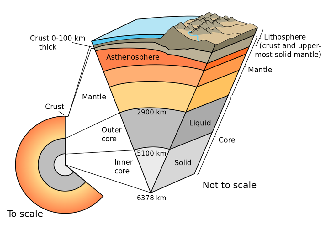
 Layers of the Earth
Core: Dense mass of nickel, iron, and radioactive elements that release massive amount of heat
Mantle: soft liquid of magma surrounding core, kept soft by intense heat from core. Because of convection currents, it is almost constantly moving.
Asthenosphere: solid, flexible outer layer of mantle, beneath the lithosphere
Lithosphere: thin, brittle layer of rock floating on top of mantle (broken up into tectonic plates)
Crust: very outer layer of the lithosphere, earth’s surface
Types of Plate Boundaries
Divergent Plate Boundary
Plates move away from each other
Rising magma plume from mantle forces plates apart
Forms: Mid-oceanic ridges, volcanoes, seafloor spreading, and rift valleys on land.
Convergent Fault Plate Boundary
Plates move towards each other
Leads to subduction (one plate being forced under another)
Forms: Mountains, island arcs, earthquakes, and volcanoes
Transform Plate Boundary
Plates slides past each other in opposite directions
Form earthquakes
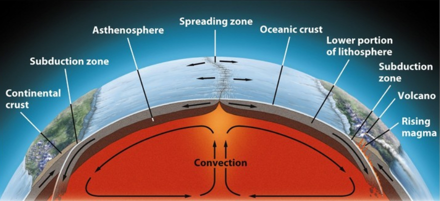
Convection Cycles
Occur in Divergent Plate Boundaries
Magma heated by earth’s core rises towards the lithosphere, melting the lithosphere
Rising magma cools & expands, forcing oceanic plates apart
Creates mid-ocean ridges, volcanoes, spreading zones or “seafloor spreading”
Magma cools, and solidifies into new lithosphere
Spreading magma forces oceanic plates into cont. (subduction zone)
Sinking oceanic plate melts back into magma
Also forces magma up, creating narrow, coastal mountains (andes) on land
Subduction in Convergent Boundaries
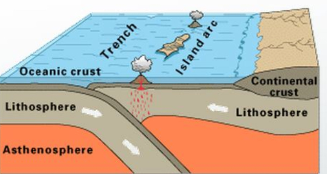
Oceanic-Oceanic - One plate subducts underneath the other
Forces magma up to lithosphere surface, forming mid ocean volcanoes
Island arcs
Off-shore trench
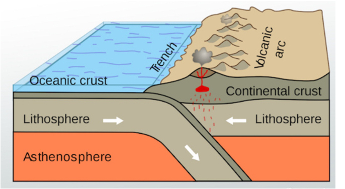
Oceanic-Continental: Dense oceanic plate subducts beneath continental Plate & melts back into magma
Forces magma up to lithosphere surface
Coastal Mountains (andes), volcanoes on land, trenches, tsunamis
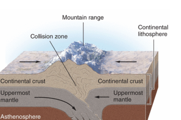
Continental-contiental one plate subducts underneath other, forcing surface crust upwards (mountains)
Ex: Himalayas
Effects of Transform Boundaries
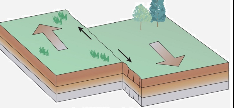
Plates sliding past each other creates a fault (fracture in rock surface)
Earthquakes are the most common activity
Occurs when rough edges of plates get stuck on each other
Pressure builds as keep sliding
but edges stay stuckWhen stress overcomes, plates suddenly release, slide past each other and release energy
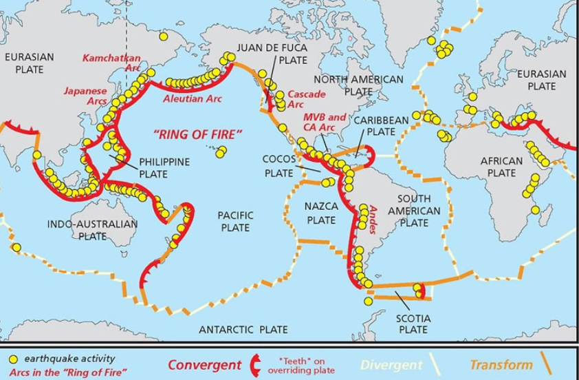
Ring of Fire: pattern of volcanoes all around pacific plate
Offshore island arcs (Japan)
Transform Faults: likely location of earthquakes.
Hotspots: areas of especially hot magma rising up to lithosphere
Mid-ocean islands like Hawaii and Iceland
Continental Drift Theory:
4.2 - Soil
Soil is a mix of geological (rock) and organic (living) components.
Sand, silt, clay
Humus: main organic part of soil (broken down biomass like leaves, dead animals, waste, etc.)
Nutrients: ammonium, phosphates, nitrates, water and air
Living organisms
Plants: anchors roots of plants and provides water, shelter, nutrients (N, P, K and Mg) for growth
Water: soil filters rainwater and runoff by trapping pollutants in pore spaces and plant roots. Clean water enters groundwater and aquifers
Nutrient Recycling: Soil is the home to decomposers that break down dead organic matter and return nutrients to the soil
Habitat: provides a habitat for organisms like earthworms, fungi, bacteria, moles, and slugs.
Weathering and Erosion
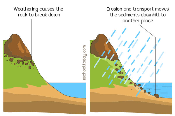
Weathering
Breakdown of rocks into smaller pieces
physical (wind, rain, freezing/thawing of ice)
Biological (roots of trees crack rocks)
Chemical (acid rain, acids from moss/lichen)
Weathering of rocks leads to soil formation
Broken into smaller and smaller pieces
Carried away and deposited by erosion
Erosion
Transport of weathered rock fragments by wind and rain
Carried to new location and deposited (deposition)
Soil Formation
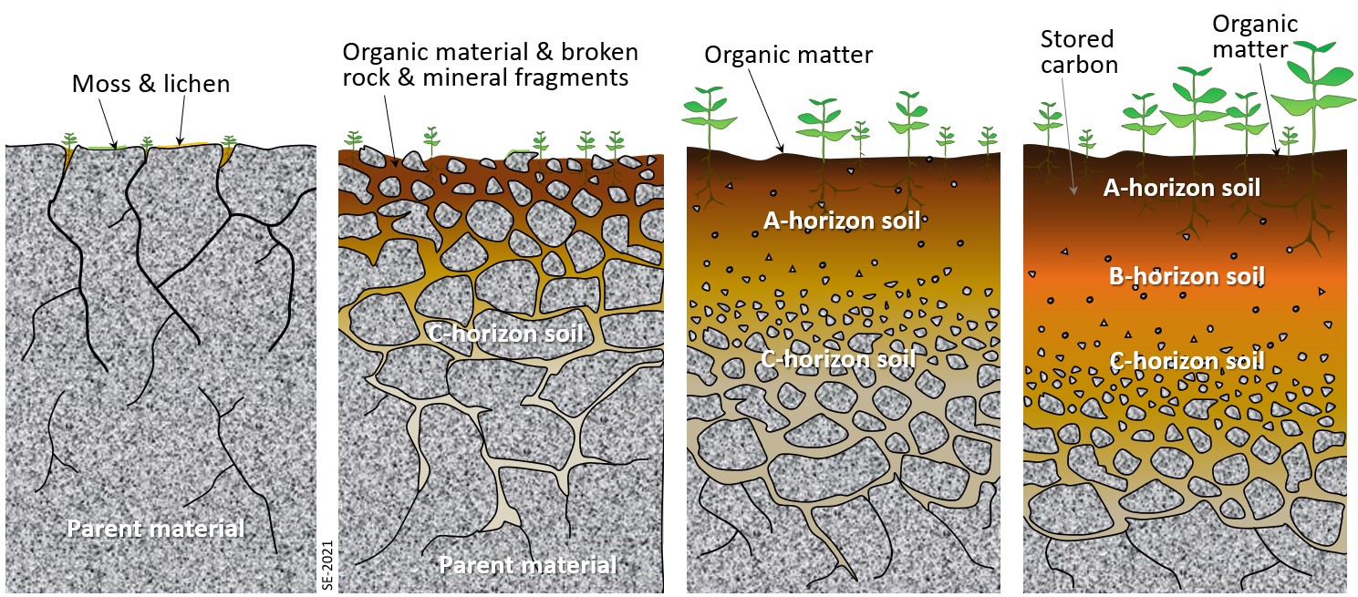
From below ground
Weathering of parent material produces smaller, and smaller fragments that make up geological/inorganic part of soil.
Sand, silt, and clay
Minerals
From above ground
Breakdown of organic matter adds humus (organic materials) to soil
Erosion deposits soil particles from other areas, adding to soil
Effects on Soil Formation
Parent material: soil pH, nutrient content
Topography: steep slope = too much erosion; more level ground = deposition
Climate: warmer = warmer breakdown of org. matter; colder. = more weathering, erosion + deposition
Organisms: Soil organisms like bacteria, fungi, worms breakdown organic matter
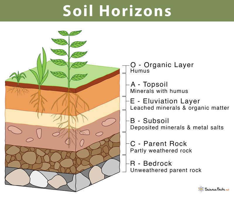
Soil Horizons (know OABC, not E or R) Mnemonic: Obviously Alligators Boycott Cats.
O-Horizon: layer of organic (plant roots, dead leaves, animal waste, etc) on top of soil
Provides nutrients and limits H2O loss to evap.
A-Horizon: aka topsoil; layer of humus (decomposed organic matter) and minerals from parent material
A-Horizon has most biological activity (earthworms, soil microbes) breaking down organic matter to release nutrients
B-Horizon: aka subsoil; lighter layer below topsoil, mostly made of minerals w/little to no org. matter
Contains some nutrients
C-Horizon: least weathered soil that is closest to the parent material, sometimes called bedrock
Soil Degradation
The loss of the ability of soil to support plant growth
Loss of topsoil: Tiling (turning soil for agriculture) and a loss of vegetation disturb soil and make it more easily eroded by wind and rain
Loss of topsoil dries out soil, removes nutrients and organisms that recycle nutrients
Compaction: compression of soil by machines (tractors, bulldozers, etc.), grazing livestock, and humans reduces the ability to hold moisture
Dry soil erodes more easily
Dry soil supports less plant growth, less root, more erosion
Nutrient Depletion: repeatedly growing crops on the same soil removes key nutrients (N, P, K, Na, Mg) over time
Reduces ability to grow future crops
4.3 - Soil Composition and Properties
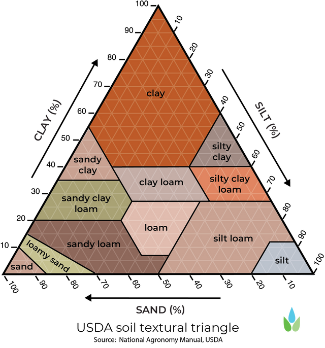
Soil Particle Size, Texture, and Porosity
Geological (rock) portion of soil is made up of 3 particles
Sand > Silt > Clay
(biggest to smallest)
Soil Texture: is the % of sand, silt, and clay in a soil
Always adds up to 100% ex: 40-40-20
Because sand is bigger, it has bigger pores (empty spaces between particles)
This allows air and water to enter sandy soil easily-
Clay has the smallest pores, so it’s harder for air + water to enter clay-heavy soils
Porosity is the amount of pore space a soil has
More sand in a soil = more porous/higher porosity (easier for water + air to enter)
More clay in a soil = less porous/less porosity (harder for water + air to enter)
Soil Texture Chart
Soil texture is determined by clay, sand, silt %
Ex: Loam = 40-40-20, sand, silt, clay
Or 45% sand 35% silt, 20% clay: loam
Tips for using Soil Texture Chart
Always start on bottom with sand %
Move out diagonally to the point where sand + silt meet
Then go straight over to clay
Make sure it adds up to 100%
Porosity, permeability, and H2O Holding Capacity
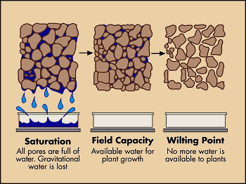
Porosity: the pore space within a soil (more sand, more porous)
Permeability: how easily water can move through a soil
More porous = Higher permeability
Positive relationship between porosity + permeability
H2O holding capacity: how well water is retained, or held by a soil
More porous/permeable = lower H2O holding capacity
inverse relationship between porosity/permeability and H2O holding capacity
Effect on Soil Fertility
Soil that is too sandy (too permeable) drains water too quickly for roots + dries
Clay-Heavy soil doesn’t let H2O drain to roots, or waterlogs (suffocating them)
Ideal soil for most plant growth is loam, which balances porosity or drainage, with H2O holding cap.
Soil Fertility: The ability of soil to support plant growth
Nutrients
N, P, K, Mg, Ca, Na
Factors that increase soil nutrients
Organic matter (releases nutrients)
Humus (holds and releases nutrients)
Decomposer activity (recycles nutrients)
Clay (negative charge binds positive nutrients)
Bases (Calcium carbonate and limestone)
Adding Calcium Carbonate/Limestone can allow soil to better hold onto nutrients!
Factors that decrease soil nutrients
Acids leach pos. charge nutrients
Excessive rain/irrigation leaches nutrients
Excessive farming depletes nutrients
Topsoil erosion
Water
Needs to hold water, but not too much
Factors that increase H2O holding cap.
Aerated soil (biological activity)
Compost/Humus/Organic Matter
Clay content
Root structures, especially natives
Factors that decrease H2O holding cap.
Compacted soil (machines, cows)
Topsoil erosion
Sand
Root loss
Characteristic | How to test | What it tells you |
|---|---|---|
Texture | Let soil settle in jar of water. Measure 3 layers that form (sand, silt, clay) | % of sand, silt, and clay - how porous or permeable soil it |
Permeability | Time for H2O to drain through column of soil | How easily water drains through soil. Too high, soil dries out. Too low, roots don’t get water or drown. Medium = optimal |
pH | pH strip - H+ ion concentration | How acidic (low pH) or basic/alkaline (high pH) soil is. More acidic soil = less nutrient availability |
Color | Compare w/soil book color chart | The darker, the more humus. the more nutrients and moisture |
Nutrient Level | Measure ammonium, nitrate, or phosphate lvl | Higher nutrient levels = more plant growth. Low level could indicate acidic soil, depletion |
4.4 - Atmosphere
Nitrogen (N2) - 78%
Mostly in the form of N2 (unuseable to plants without being fixed)
Oxygen (O2) - 21%
Produced by photosynthesis in plants & needed for human/animal respiration
Argon (Ar) - 0.93%
Inert, noble gas
Water Vapor (H2O) - 0.4%
Varies by region & conditions; acts as a temporary GHG, but less concerning than CO2
Quickly cycles through atmosphere
Carbon Dioxide (CO2) - 0.04%
Most important GHG; leads to global warming
Removed from atm. by photosynthesis
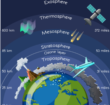 Mnemonic for layers - The Silly Monkeys Twirl Endlessly
Troposphere:
Tropo means change (weather occurs here) - 0-16 km, most dense due to pressure of other layers above it
Most of atmosphere’s gas molecules are found here
Ozone (O3) in the troposphere is harmful to humans (respiratory irritants) & damages plant stomata, and forms smog
Most dense layer
Stratosphere: (“S” for second)
16-60 km; less dense due to less pressure from layers above
Thickest O3 (ozone) layer is found here; absorbs UV-B & UV-C rays which can mutate DNA of animals (cancer)
Mesosphere:
Meso is for middle; 60-80 km, even less dense
Thermosphere:
Therm = hottest temp;
absorbs harmful X-rays & UV radiation
Charged gas molecules glow under intense solar radiation producing northern lights (aurora borealis)
Exosphere:
Outermost layer where the atmosphere merges with space
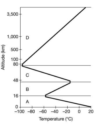
Troposphere: Temperature decreases as air gets further from warmth of earth’s surface
Stratosphere: Temperature increases because top layer of stratosphere is warmed by UV rays (like pool surface)
Mesosphere: Temperature decreases because density decreases, leaving fewer molecules to absorb sun
Coldest place on earth (-150F)
Thermosphere: Temperature Increases due to absorption of highly energetic solar radiation
Hottest place on earth (3,100F)
4.5 - Wind Patterns
Air Properties
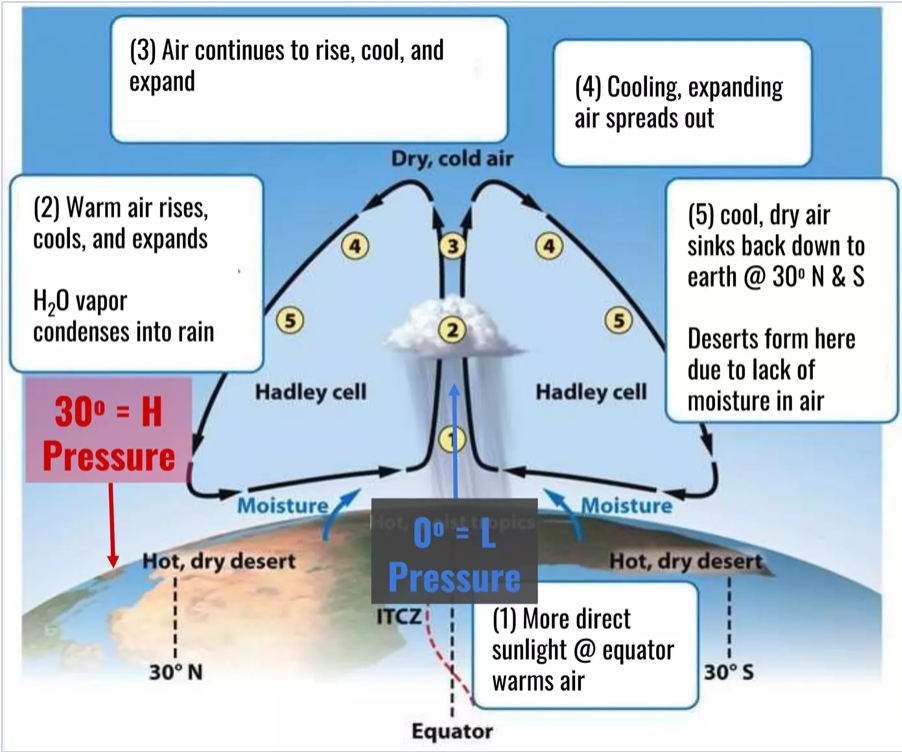
Warm air rises
Warm air holds more moisture
Rising air expands and cools
Cool air can’t hold as much H2O vapor (condenses → rains)
After cooling & expanding, air sinks
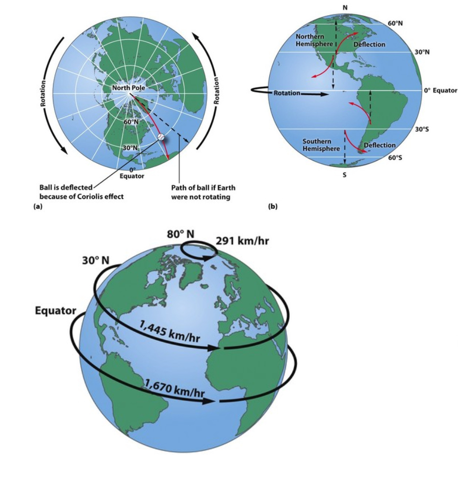
Coriolis Effect
Coriolis Effect is the deflection of objects traveling through the atmosphere is due to the spin of the earth
Air at 30° moves back due to the low pressure of equator
Wind between 0-30° moves. from E→W
Due to earth spinning W→E
Wind between 30-60° moves W→E
Due to earth spinning faster at 30° then 60°
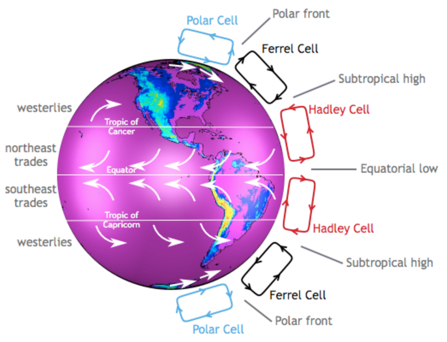
Global Wind Patterns
Air moves out from 30° to 0° and 60° due to H pressure at 30° & and L pressure at 0° and 60°.
Air rising at equator = low pressure,
Air sinking down at 300 = high pressure
0-30° winds blow E → W (Eastern Trade Winds)
Drives ocean current clockwise in N and counterclockwise in S
30- 60°: winds blow W → E (Westerlies Wind)
Drives weather patterns of N America
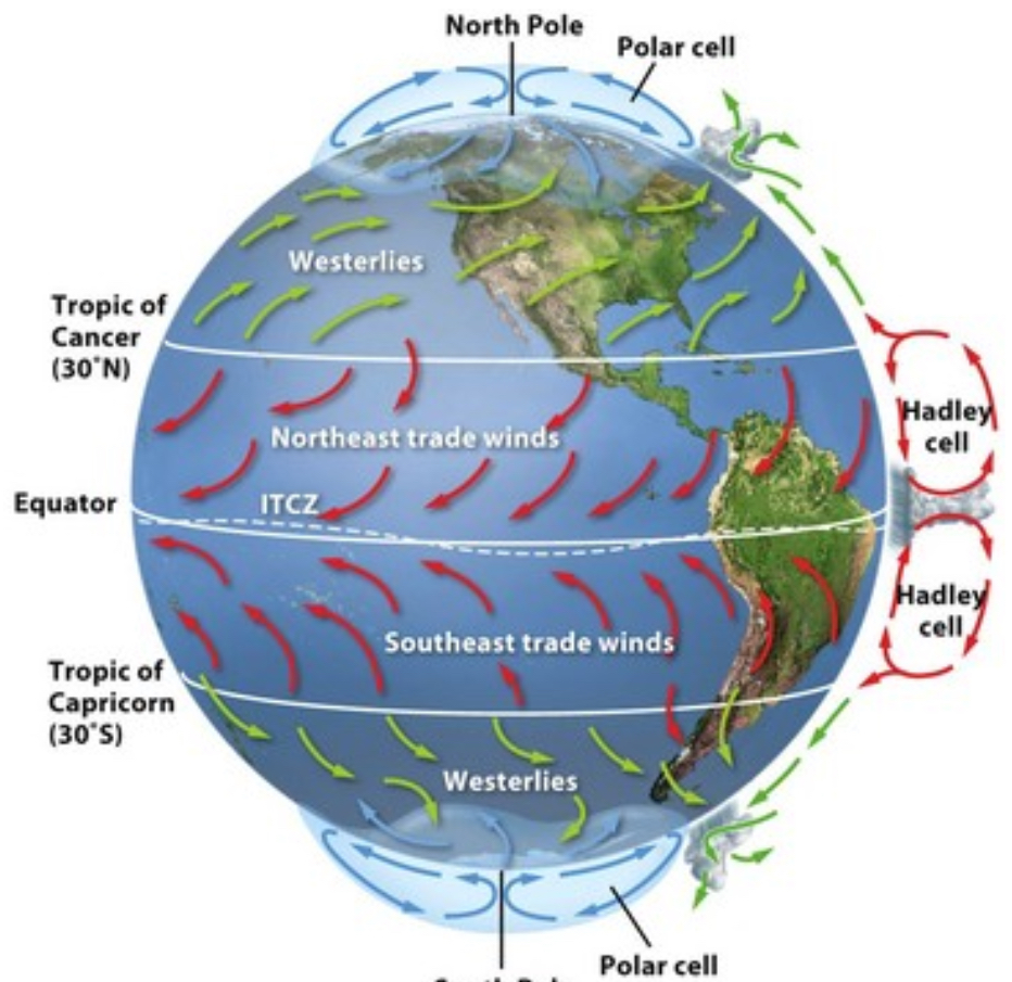
Hadley Cells rise at 0° and drop and 30°
Ferrell Cells drop at 30° and rise at 60°
Polar Cells rise at 60° and drop at 90° (the poles).
4.6 - Watersheds
A watershed is an anywhere where water collects. It can be filled by runoff or rivers. It’s often a part of a river system and water will continue to flow down until it reaches the ocean.
The more vegetation, the less runoff, so the less watershed volume
The greater slope, the more watershed volume
Soil Permeability determines how much runoff there is
Polluted runoff and rivers can pollute a watershed
Solutions to Watershed Pollution
Cover crops (pulls pollutants from the soil, not used for profit)
Riparian buffer (plants along the water's edge)
4.7 - Radiation and Seasons
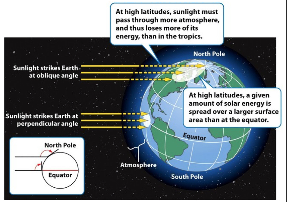
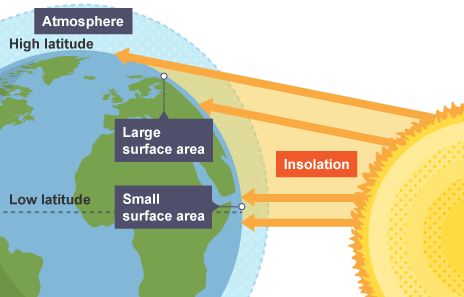
Insolation is the amount of solar radiation (energy) that reaches an area. It is measured in Watts per Meters squared.
Solar intensity of insolation (W/m2) depends on:
Angle: how directly rays strike earth’s surface
The amount of Atmosphere sun’s rays pass through
The Equator has higher insolation than higher latitudes
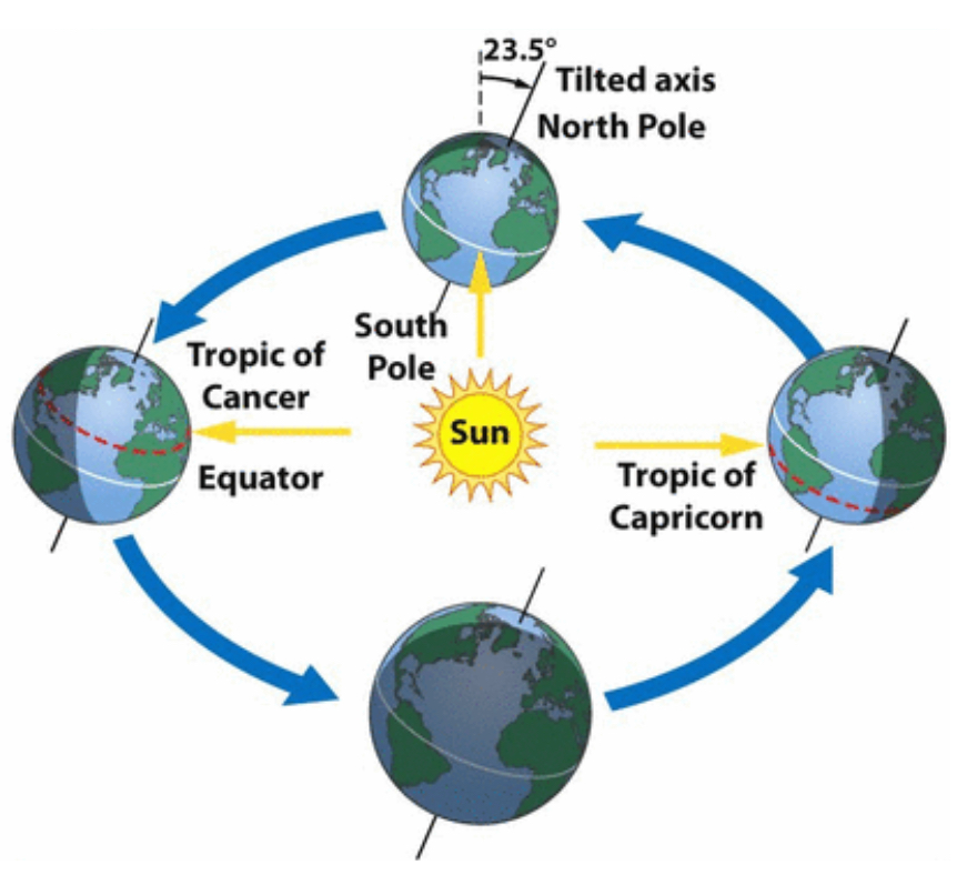
The orbit of the earth around sun & the earths tilt on its axis changes angle of sun’s rays
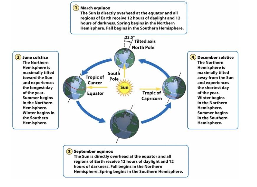
This causes varying insolation, varying length, and seasons.
The tilt of earth’s axis stays fixed during orbit
June & December Solstices: N or S hemisphere is maximally tilted toward sun (summer/winter)
March & Sept. Equinox: N & S hemispheres equally facing sun (Equinox - Equal)
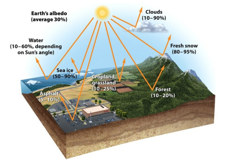
Albedo: the proportion (percentage) of light that is reflected by a surface
Surfaces with higher albedo reflect more light, and absorb less (ice/snow)
Absorb less heat
Surfaces with low albedo reflect less light, and absorbs more (water)
Absorb more heat
surface temperature is affected by albedo
When sunlight is absorbed by a surface, it gives off infrared radiation (heat)
Areas with lower albedo, absorb more sunlight light (heat)
Urban Heat Island: urban areas are hotter than surrounding rural area due to low albedo of blacktop
Polar regions are colder in part due to higher albedo
4.8 - Climate and Geography
Climate is largely determined by insolation (latitude, angle of insolation, & atmosphere)
Higher latitudes: cooler, less precipitation (especially at 30 degrees latitude)
The equator receives the most intense insolation: higher temp, air rises, high precipitation
Geography also plays a role
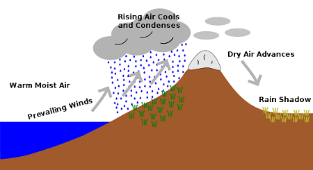
Mountains: disrupt wind & produce rain shadow effect
Oceans: moderate temperature & add moisture to the air
Warm, moist air from ocean hits the “windward” side of the mountain, rises, cools, (condensing H2O vapor & causing rain) creating lush, green vegetation
Dry down “leeward” side of mtn, warming as it sinks
Leads to arid (dry) desert conditions.
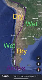
Eastern trade winds blow moist air from Atlantic across South Asia
Windward (E) side of Andes receives heavy rainfall
Leeward (W) side of Andes receives arid/dry air
~30 latitude also contributes to lack of rain, high pressure, dry, descending air from Hadley cell
4.9 - El Niño and La Niña
Gyres: large ocean circulation patterns due to global winds
(clockwise in N hemisphere, counterclockwise in S hemisphere)
Covers whole oceans
Eastern Trade Winds between 0-30° push water along the equator E → W
Westerlies between 30-60° push mid latitude currents W → E
Upwelling Zones: areas of ocean where winds blow warm surface water away from a land mass and draw up cold, deep water to replace it. Brings O2 and nutrients to the surface, so these areas have productive fisheries
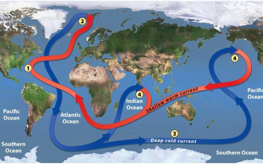
Thermohaline Circulation
Connects all of the world’s oceans, mixing salt, nutrients, and temperatures throughout
Warm water from the Gulf of Mexico moves toward North Pole
Water cools and evaporates as it moves toward poles
Saltier and colder water at poles is more dense, making it sink
The water the spreads along ocean floor
Rises back up into shallow warm ocean current upwelling zones
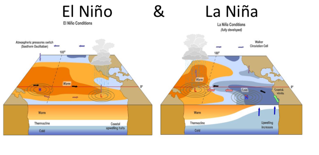
El Niño and La Niña
ENSO: pattern of shifting atmospheric pressure & ocean currents in the pacific ocean between South America, Australia, and Southeast Asia.
ENSO - El Nina Southern Oscillation
Oscillates, or shifts regularly from El nino (warmer, rainier) to La Nina (cooler, drier) conditions along coast of South America
La Niña conditions are just more extreme normal conditions.
El Niño
No upwelling in Latin America
Warm Latin America water
Warm water in Asia
Droughts/no rainfall in Asia
Rainfall in Latin America
High Pressure in Asia
Low pressure in Latin America
La Niña
Rain in Asia
Warm water in Asia
Cold water in Latin America
Upwelling in Latin America (good for fishing)
High pressure in Latin America
Low pressure in Asia