Lecture 7: Introduction to Network Analysis
I. Basics of a Network
Network
Interconnected set of points (nodes) and lines (edges)
Examples:
Information networks
Social networks
Stream networks
Transportation networks
Connectivity allows for analysis / problem solving
Types of Networks:
Utility Networks
including water mains, sewage lines, and and electrical circuits. These networks are generally directed.
Transportation Networks
including roads, railroads, and flight paths. These networks are generally undirected
Networks based on social connections
3D Network Datasets
Three-dimensional network datasets enable you to model the interior pathways of buildings, mines, caves, and so on.
Network in GIS
GIS networks consist of interconnected lines (known as edges) and intersections (known as junctions) that represent routes upon which people, goods, etc. can travel
The object traversing the network follows the edges, and junctions appear when at least two edges intersect
II. Network Dataset in GIS
Network Dataset
Set of nodes connected by lines
Represent some type of flow
Incorporate flow rules (e.g. time, distance)
Rules determine cost and dictate how objects can move through the network
Types of rules:
Direction - one-way street
Barriers
Time of day
Node restrictions - stroke centers
Sequence - stop 1 then stop 2
Cost: What is the impact of an object flowing through the network?
Network Elements
Edges
connect to other elements (junctions) and are the links over which agents travel
Junctions
connect edges and facilitate navigation from one edge to another
Turns
store information that can affect movement between two or more edges
Network Attributes
Properties of the network elements that control traversability over the network
the time to travel a given length of road
which streets are restricted for which vehicles
the speeds along a given road
which are one-way streets
Cost
work as impedances, which penalize traversal over an element in the network. Network datasets must have at least one cost attribute.
Descriptor
contain general information to calculate the values for other three attributes. For example: Number of lanes, speed limit
Restriction
prohibit traversing certain edges (roads) in certain directions.
Example: One-way Street, closures, etc.
Hierarchy
differentiates among road types to help network analysis, and it allows a network dataset to assign priority.
Example: Highway, Primary road, etc.
Connectivity
based on geometric coincidences of line endpoints, line vertices, and points and applying connectivity rules that you set as properties of the network dataset
if they do not share any coincident endpoints or vertices, no connectivity policy will create a junction at the point of intersection
Multimodal network example:
street and subway with separate connectivity that joins only at metro entrance
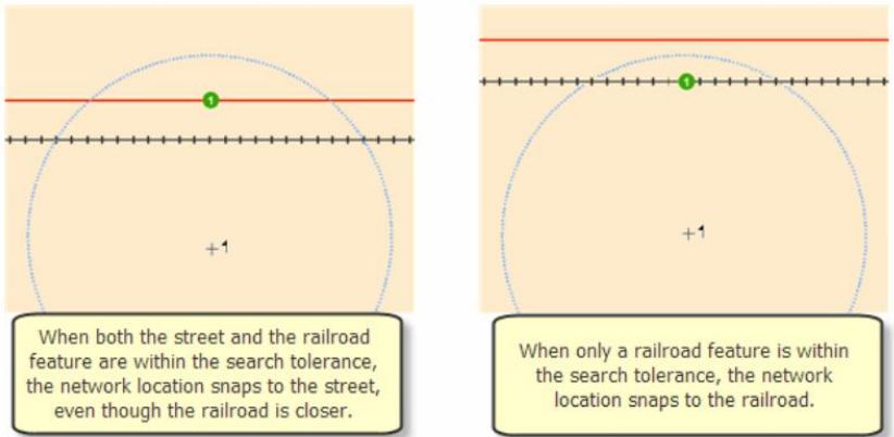
Network Locations
Finding network locations (i.e. stops, barrier)
Search tolerance
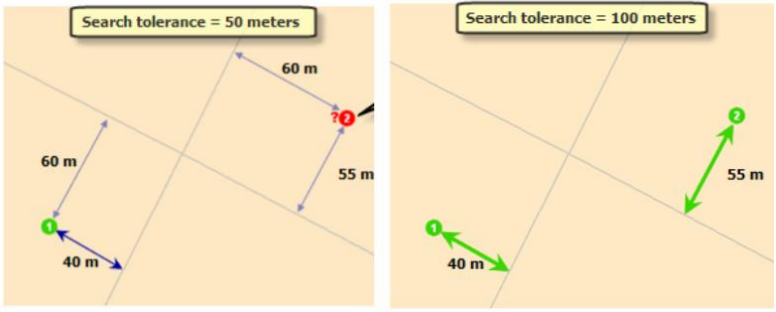
Snapping environment
III. Network Analysis
Network Analysis
based on the mathematical sub-disciplines of graph theory and topology
a set of analysis techniques used with networks (features that are topologically structured, e.g. roads, river, pipeline, cables, etc.)
Topological Relationship
Topology is the arrangement of how point, line, and polygon features share geometry
Topology is used for the following:
Constrain how features share geometry. For example, adjacent polygons such as parcels have shared edges, street centerlines, and census blocks share geometry, and adjacent soil polygons share edges.
Define and enforce data integrity rules: no gaps between polygons, no overlapping features, and so on.
Support topological relationship queries and navigation, such as identifying feature adjacency and connectivity.
Support editing tools that enforce the topological constraints of the data model.
Construct features from unstructured geometry, such as creating polygons from lines
Network Analysis Workflow
Organize the Network Analysis Settings
Add a dataset in your GIS project working file
Create the Network Analysis Layer
Input Network Analysis Features and Records
Add network locations
Set analysis properties
Perform analysis and display results
IV. Examples
Types of Network Analysis
Shortest Path / Best Route
One common type of network analysis is finding the shortest path between two points
In a network of streets, the “shortest” route can either refer to different variables, such as: distance, time, and monetary cost (such as purchasing a plane ticket)
Traveling Salesman
The traveling salesman is defined as reaching every point in a network in the most efficient way possible
It is derived from the idea of a salesperson trying to reach a planned set of cities to sell his or her product in the quickest, most efficient way possible, either through money made, or time
Network Partition (Service Area)
Network partition is a dividing up of regions in a network to zones or subcategories
These regions are sized based on proximity to specific points in a network. This is common for fire stations in metropolitan areas.
Closest facility
Calculate the nearest X number of facilities to an incident or point of interest
Closest can be based on network distance or time
Set up a cutoff
Find all the hospitals within 5 minutes of an accident
Find all the clinics within 2 miles of a home address
Origin-destination (OD) cost matrix
Creates a cost matrix from multiple origins to multiple destinations
Good for calculating distance or time between multiple start and end points
Location-Allocation
Helps you choose which facilities from a set of facilities to operate based on their potential interaction with demand points
Other Applications:
Transportation Modeling
Utility and Infrastructure Management
Power Grids - Identifying the shortest path for electricity distribution and detecting power outages
Water Supply Networks - Optimizing pipe layouts to ensure efficient water distribution
Telecommunications - Finding the best locations for cell towers and routing fiber optic cables
Emergency Response and Public Safety
Ambulance & Fire Station Coverage - Determining the fastest routes for emergency vehicles
Disaster Management - Identifying safe evacuation routes during floods, wildfires, or earthquakes
Crime Analysis - Studying movement patterns to predict and prevent criminal activities
Environmental Management & Ecology
Wildfire Corridors - Identifying safe pathways for animal migration.
River & Watershed Networks - Analyzing water flow to predict flooding or pollution spread
Deforestation Monitoring - Studying connectivity between forest patches to predict biodiversity
Social Network & Human Mobility Analysis
Urban Mobility Studies - Understanding how people move through cities to improve public transport
Epidemiology (Disease Spread) - Mapping virus transmission pathways (e.g. COVID-19 contact tracing)
Market Analysis - Finding the best locations for new businesses based on customer movement patterns
Maritime & Aviation Navigation
Ship Route Optimization - Avoiding obstacles like reefs, icebergs, and high-traffic zones
Air Traffic Control - Managing flight paths to reduce delays and improve safety
Search and Rescue Operations - Identifying the most probable locations of missing ships or aircraft