GEOM 3 (Jan 13)
Typed
Datums and Earth models, ellipsoids and geoids
A Geodetic Datum is a tool used to define the shape and size of the earth, as well as the reference point for the various coordinate systems.
The geoid is the most accurate representative shape of the earth.
The Geoid is the shape that the surface of the oceans would take unde rinfluence of Earths gravitation and rotation alone, in the absence of other influences such as winds and tides.
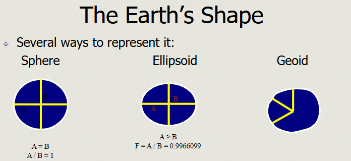
Earth is not a sphere, but an ellipsoid, because the centrifugal force of the earth’s rotation “flattens it out”.
Spheroid: that is a type of ellipsoid that is really, really close to being a sphere
Datums
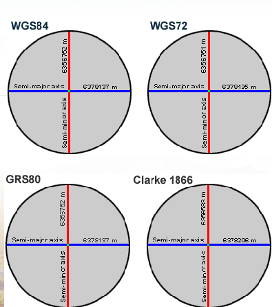
Two different sphereiods have slightly different major and minor axis lengths
Google Earth uses WGS84
Define the shape of the earth including: Ellipsoid (Shape and Size)
Origin and Orientation
Aligns the ellipsoid so that it best in region you are working
A Datum defines the position of the spheroid relative to the center of the earth
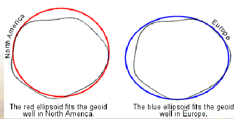
NAD represents the red ellipsoid
ED represents the Blue ellipsoid
Dependant on the preferred use you would select which Datum best fits your requirements.
Hundreds of different datums exist
Referencing coordinates to the wrong datum can result in position errors of hundreds of meters.
NAD27 and NAD83 common in North America
NAD83 preferred
Uses center of the earth as starting point
Many GPS systems use WGS84
Geographic Coordinates Systems: Latitude and Longitude
Projections
AI
Understanding Earth's Shape
The Earth's shape can be conceptualized as a geoid, which represents the most accurate depiction of the planet's physical dimensions, including gravitational effects and the irregularities of the surface due to mountains and ocean depressions.
However, while the geoid is a precise model, it is computationally complex and challenging to use in practical applications, which leads to the adoption of simpler models.
The Geoid vs. Ellipsoid
A compromise in modeling the Earth's shape is made by adopting an ellipsoidal model, which simplifies calculations while still providing a reasonable approximation of the Earth's dimensions.
The ellipsoid has two axes: the major axis (longer) and the minor axis (shorter), which define its elliptical form. This shape differs from a perfect sphere, leading to the need for defining both the ellipsoid's dimensions and its orientation.
Defining Key Components
When defining the ellipsoidal model, three primary components are necessary:
Shape: Defined as an ellipse due to the unequal lengths of the two axes.
Size: Determined by the values of the semi-major and semi-minor axes.
Point of Reference: The center of the Earth serves as this reference point for modeling.
Examples of standards using this model include WGS 84, which is integral to GPS technology and Google Earth, allowing users to pinpoint their location using a standardized reference frame.
Comparison of Different Models
The discussion extends to comparing other datums such as GRS 80 and NAD 83, both of which have been used in North America. While these share similarity in their ellipsoidal nature, they are distinct models with different reference points.
NAD 83 aligns closely with WGS 84, allowing for compatibility of spatial data, whereas older datums like NAD 27 differ significantly, often leading to discrepancies in location data by significant distances.
Importance of Datum Selection
Choosing the correct datum is crucial when working with geographic data, especially within distinct regions. For example, using a model suitable for North America (like NAD 83) for data collected in Europe could lead to substantial errors.
Each geographic region may have its own optimally fitted datum to ensure accuracy, and when collecting data, analysts must recognize these standards to maintain the integrity of their geographic information systems (GIS).
Practical Application of Datums
When integrating data from various sources, such as GPS data (WGS 84) with older datasets (NAD 83 or NAD 27), one must be cautious. The historical data must be accurately paired with corresponding models to avoid projection errors.
The presentation emphasizes the importance of being aware of the inherent inaccuracies and ensuring that all datasets align properly within a chosen datum framework. This practice is vital for accurate analysis, data representation, and decision-making in geospatial studies.