knowt logo

GEOL 101 Exam Review 3

Chapter 9 - Geologic Structures

Cratons and shields (4)

  • Craton: very old, strong, and stable continental crust. The oldest rocks on Earth.

  • Two cratonic provinces

    • Shields: consist of Precambrian igneous and metamorphic rocks, exposed at the surface.

    • Platforms: sedimentary cover that is draped over Precambrian shield basement rock.

Plate interactions and the 4 types of orogenesis (7-11)

  • Orogenesis: the process of mountain formation.

  • Convergence→←: mountains form where new crust has been added onto the craton.

    • Oceanic to continental collisions: subduction and exotic terranes

    • 1. Subduction

      • Subduction-related continental volcanic arc forms on the overriding plate. Accretionary prisms thicken laterally and grow upward. A fold-thrust belt develops landward of the orogen.

      • Uplift takes place because

        • 1. Compression shortens and thickens the crust

        • 2. Addition of plutons below the surface

        • 3. Volcanic material added at the surface

    • 2. Accretion of exotic terranes

      • Exotic terranes consist of island fragments of continental crust that has a separate geologic history before being sutured to the overriding plate at a convergent margin.

      • Western North America is an amalgamation of exotic terranes

    • 3. Continental to continental collisions convergence

      • When continents collide, ocean basins close and oceanic crust is pushed beneath continental crust. This action brings two pieces of continental crust together. Because continental crust is too light to sink into the Earth's mantle, it stops the process of subduction.

      • The center of the belt consists of high-grade metamorphic rocks. Fold thrust belts extend outward on either side.

      • Uplift takes place because collision leads to crustal thickening due to thrust faulting and flow folding.

  • Divergence←→: mountains also form where crust has been ripped apart from it.

    • 4. Continental rifting

      • Normal faulting in continental rifts create fault-block mountains and basins.

      • Thinning crust results in decompressional melting, which adds volcanic mountains, increases heat flow, and expands and uplifts rocks.

Types of deformation (22)

  • Rotation (tilting): change in spatial orientation by tilting.

  • Displacement (fracturing): change in location by fracturing.

    • Jointing

    • Faulting

  • Distortion (folding): change in shape by folding.

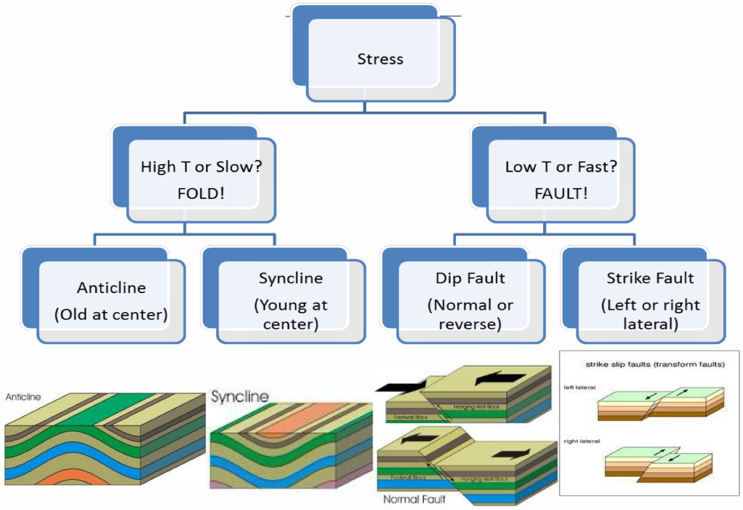
  • Brittle (shallow in crust):

    • Occurs at low temperature and pressure conditions.

    • Causes rock to break by fracturing.

    • Can occur by quick movements.

    • Displacement and rotation.

  • Ductile (deep in crust):

    • Occurs at higher temperature and pressure conditions.

    • Causes rock to deform by flowing and folding.

Stress leads to strain (24-27)

  • Stress: the force applied across a unit area.

    • A large force per area results in more deformation.

    • A small force per area results in little deformation.

    • If equal force were applied to small and large areas, the small area would deform more.

  • Strain: a change in shape or volume in response to a stress.

  • Stress is the cause, strain is the effect.

  • Compression, tension, and shear:

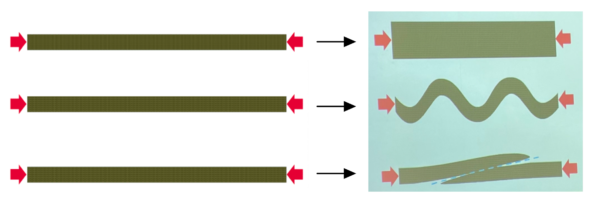
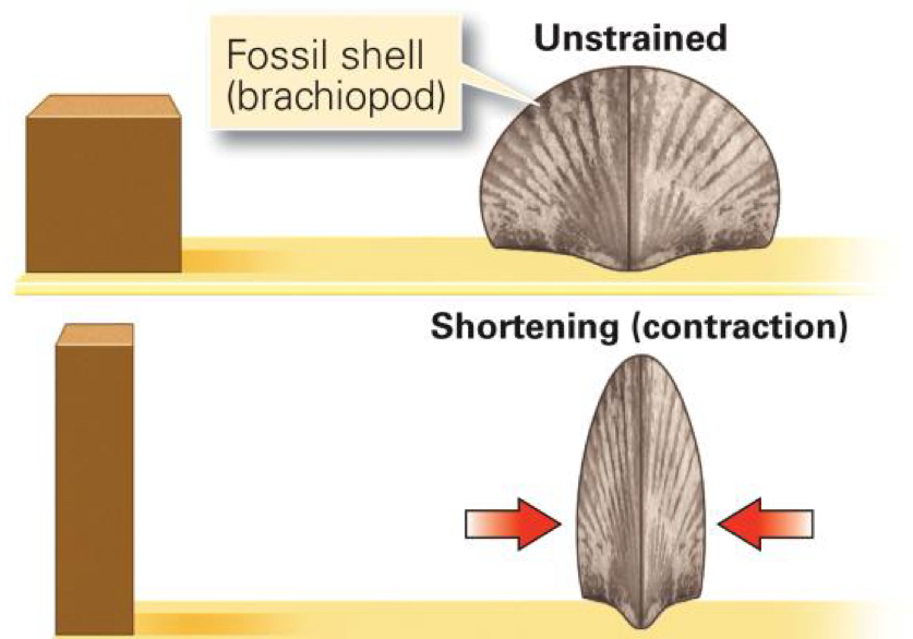
  • If the stress is compression, then the strain would be shortening.

    • Compression takes place when an object is squeezed.

    • Deformation shortens and thickens the crust.

      • Can fold, fault, or tilt rocks and leads to mountain building.
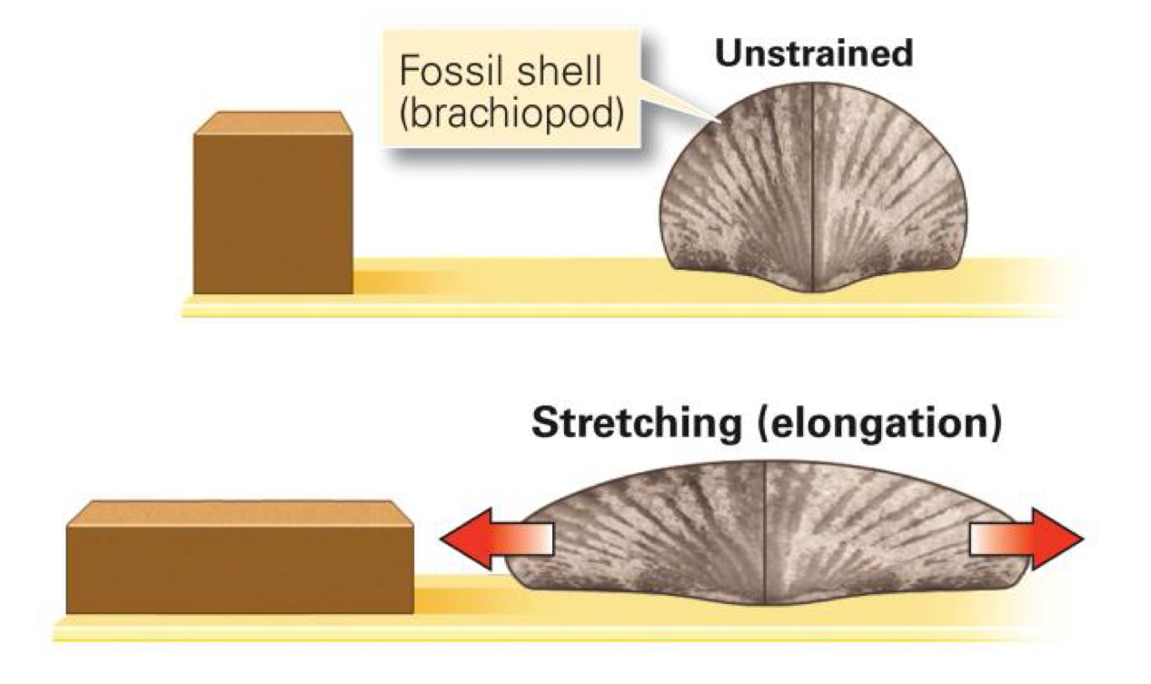
  • If the stress is tension, then strain would be elongation.

    • Tension occurs when the ends of an object are pulled apart.

    • Deformation lengthens and thins the crust.

      • Can fault, or tilt rocks and leads to crustal thinning and rifting.
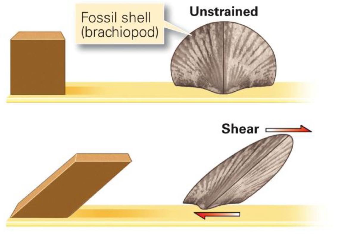
  • If the stress is shear, then strain would be shear.

    • Shear develops when surfaces slide parallel but opposite past one another.

    • Deformation neither thickens or thins the crust.

      • Can fault rocks and leads to plate slippage.
Fault definition

  • Faults: planar breaks in the crust that show displacement.

    • Micro to macro in scale.

  • Types of faults are classified by their relative motion and geometry (vertical, horizontal, or dipping).

  • Dip-slip faults: characterized by blocks that move parallel to the dip of the fault (vertical).

Dip-slip: Normal fault and example (33)

  • Normal fault: hanging wall moves down relative to footwall.

  • Brittle - tensional stress, like in regions experiencing crustal extension.

  • Example: Basin and Range

  • Death Valley

Dip-Slip Reverse/thrust faults and example (34, 35)

  • Reverse fault: hanging wall moves up relative to the footwall - high angle > 30°

  • Brittle - compressional stress, like in regions experiencing convergence.

  • Death Valley

  • Thrust fault: a type of reverse fault but with a low angle dip, < 30°.

  • Brittle - compressional stress, like convergence creating large mountain belts.

  • Las Vegas, Keystone Thrust

Strike-slip fault and example (36)

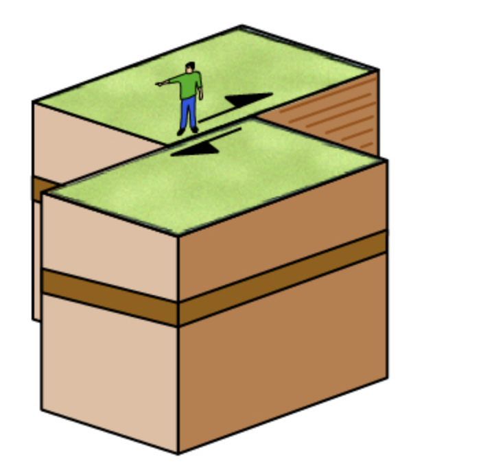
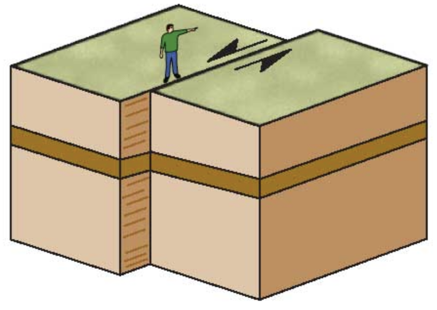
  • Strike-slip faults: when blocks move parallel to the fault plane strike. Tend to be vertical.

  • Right lateral strike-slip fault: fault block appears to move sideways and to the right past the observer’s block.

    • Only horizontal movement.

    • No large vertical motion across the fault.

    • California, San Andreas Fault

  • Left lateral strike-slip fault: fault block appears to move sideways and to the left past the observer’s block.

    • No large vertical motion across the fault.

    • California, Garlock Fault

Folds

  • Folds: occur where rock has been deformed deep below the surface from tectonic compression (continental to continental convergent boundaries).

  • Folds can form in a variety of shapes, sizes, and geometries (slide 53).

  • Orogenic settings produce large volumes of folded rock.

  • Rock must be hot or under pressure to move in a plastic manner.

  • Compression acts differently on:

    • Thin vs. thick layers

    • Crystalline vs. clastic layers

Anticlinal fold and Synclinal fold (54-55)

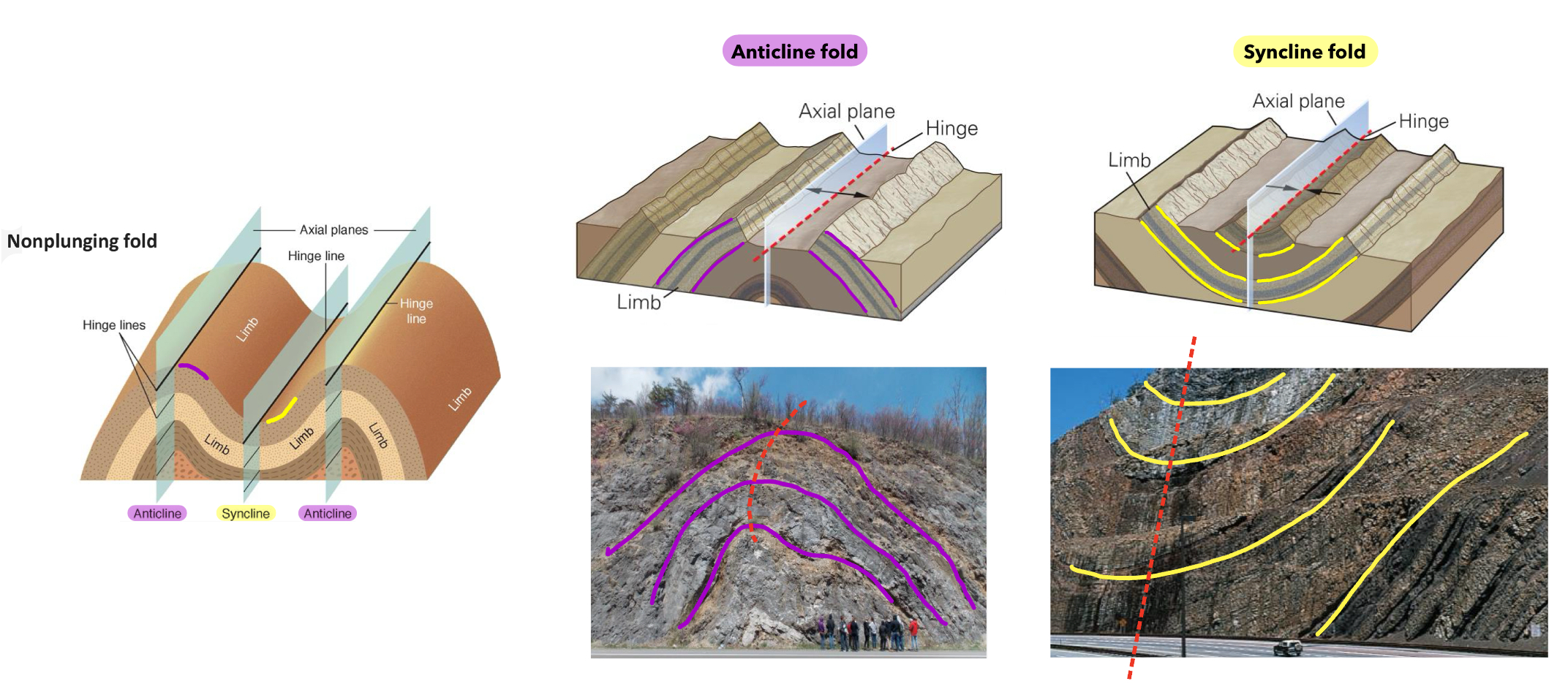
  • Anticline fold: a fold that looks like an arch. The limbs dip out and away from the hinge.

  • Syncline fold: a fold that opens upward like a trough. The limbs dip inward and toward the hinge.
Practice identifying structures (61, 62)

  • Dome: a fold with the appearance of an overturned bowl, exposes older rock in the center.

  • Basin: a fold shaped like an upright bowl, exposes younger rocks in the center.

Stress review (63)
Class Questions:

  • When erosion exceeds the rate of uplift, a mountain will appear to be reduced in elevation.

  • The type of deformation that takes place depends on temperature, pressure, rate of deformation, and amount of force.


Chapter 8 - Earthquakes

Frequency of earthquakes (4)

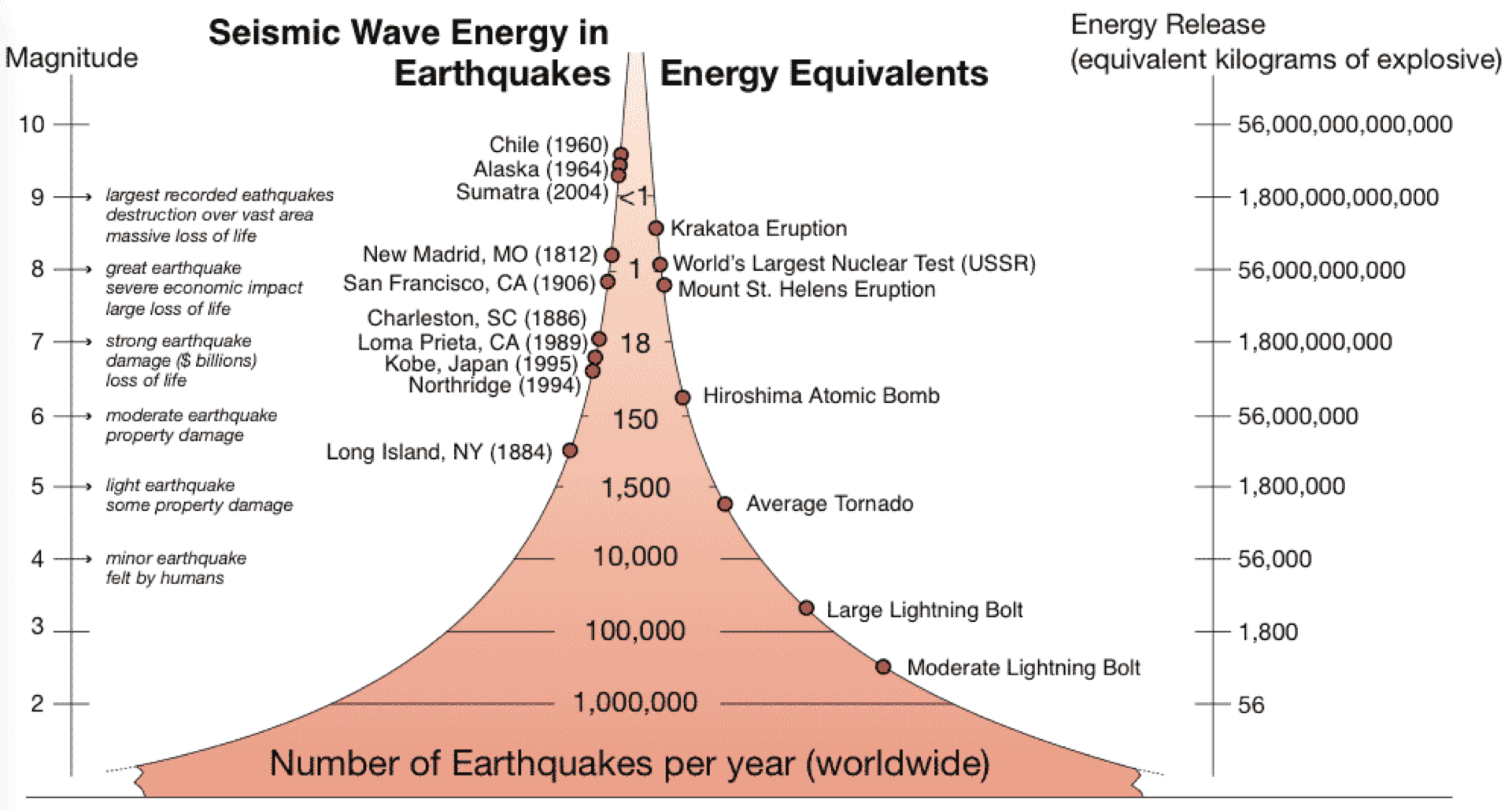
  • Common, thousands of small earthquakes everyday (<3.0)

    • More than a million detectable earthquakes a year.

  • Several hundred large earthquakes occur each year (3.0 to <8.0)

    • Very large ones occur much less frequent, 1 a year, or less (8.0 to <10.0)

Location of earthquakes along plate boundaries and depth (10-13)

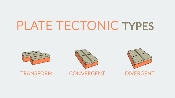
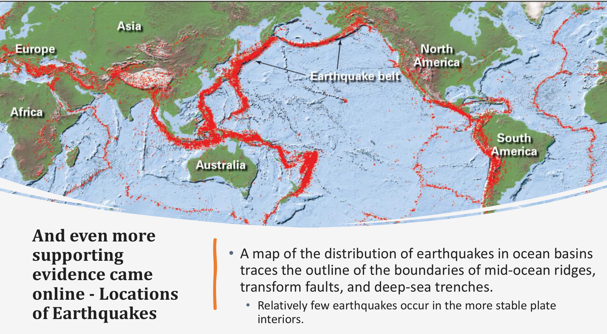
  • Earthquakes at plate boundaries

    • Shallow: divergent and transform

      • Occurs within the top 60 km of the crust.

    • Intermediate and deep: convergent

      • Intermediate occurs between 60-300 km depth.

      • Deep occurs between 300-660 km depth.

  • Divergent Plate Boundaries

    • Mid Ocean Ridges (MORS)

      • Two types of faulting typify MORS; normal faults at the spreading ridge axis and strike-slip faults along the transforms.

      • MOR earthquakes are shallow (<10 km deep) and generally low energy.

    • Continental Rift Zones

      • Continental rifts occur where tension and stretching creates normal faults.

      • Rifting generates shallow earthquakes, as well, except these normal faults are on land so impact structures and people.

        • Examples: Basic and Range Province, Rio Grande Rift (New Mexico, East African Rift

  • Transform Plate Boundaries

    • Large continental transform earthquakes happen in the shallow crust often cause major disasters.

    • The San Andreas Fault runs through western California, where the Pacific plate moves north and the North American plate moves south.

    • The San Andreas Fault is highly active, with hundreds of earthquakes each year, moving at a rate of 6cm/year.

  • Convergent Plate Boundaries

    • Convergent plate boundaries have shallow, intermediate, and deep earthquakes.

    • Normal faults form where the down going slab bends the overriding plate downward.

    • Large thrust faults occur at the contact between plates when the overriding plate can snap back, creating a huge megathrust earthquake → these can cause tsunamis.

    • Earthquakes are rare below 660 km as mantle is too ductile.
Seismic waves, body vs. surface waves (20, 21)

  • Seismic waves: waves of energy generated when rock in the crust breaks; causes shaking during earthquakes.

  • Earthquakes produce waves of energy which arrive in a distinct sequence and with distinct motion.

    • Body waves: (P-waves and S-waves)

    • Surface waves (L-waves and R-waves)

  • Energy releases moves in all directions, like ripples in a pond.

  • Body waves: in earth’s interior they lose their amplitude rapidly as they get farther from the earthquakes because they spread out inside the volume of the earth.

  • Ability for seismic waves to travels through material depends on the type of material and the rock type.

    • Highly fractured rock and crushed material absorbs more seismic energy.

    • More compact or crystalline material allows seismic waves to transfer faster.

  • Seismic waves travel faster through solids.

  • S-waves can’t travel through liquids.

Class Question (22)

  • Suppose you are buying a house in an earthquake-prone area. What option is likely to stay safe during an earthquake?

    • A house in the Sierras of California, built on granite (its built on solid bedrock).

Type, speed, and level of damage of seismic waves (24-27, 31)

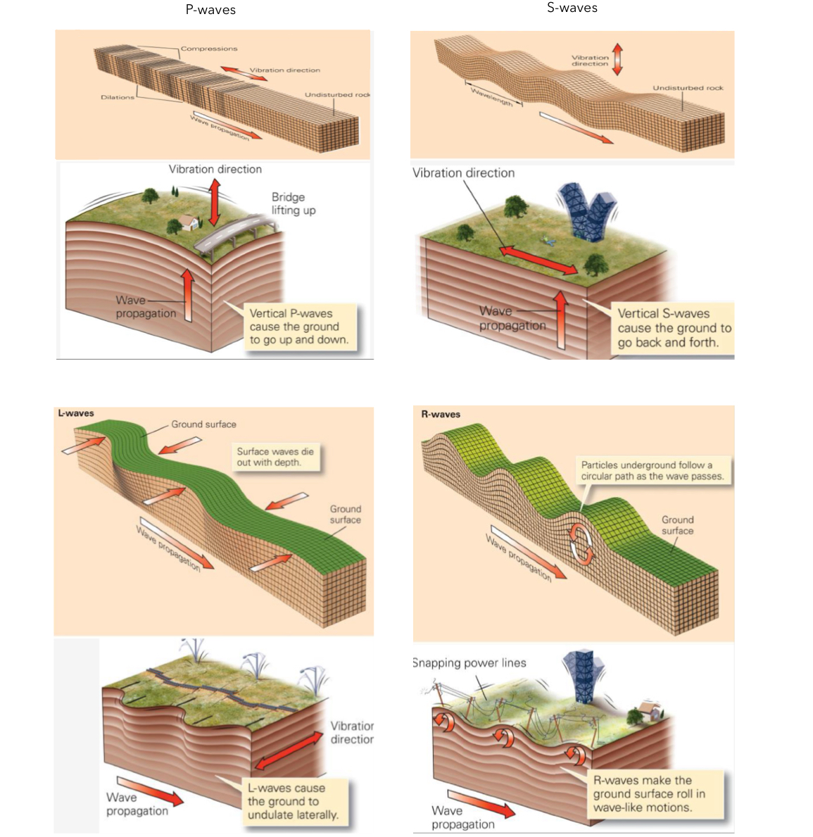
  • P-waves: fastest seismic waves that can travel through solids, liquids, and gases.

    • Compressional waves travel in the same direction that the waves move.

      • Material is compressed and expanded as the wave passes through it.

      • Produced rapid, bucking, up and down motion.

    • Moves about 4-7 km/s

  • S-waves: travels perpendicular to wave movement.

    • Shear waves

    • Back and forth motion, higher in amplitude

    • Stronger than P-waves, cause extensive damage.

    • Arrives second

    • Travels through solids only.

    • Travels about 2-5 km/s

  • L-waves: surface waves that travel along Earth’s exterior.

    • Love waves

    • Slowest, arrives third, follow quickly behind S-waves

    • Most destructive.

    • L-waves are S-waves that intersect the land surface.

    • Move the ground back and forth like writhing snake.

  • R-waves: P-waves that intersect the land surface.

    • Rayleigh waves

    • Last to arrive

    • Cause ground to ripple up and down like water and ripples

    • Last longer that other waves

    • Cause extensive damage

Earthquake magnitude (38)

  • Magnitude scales: logarithmic, each step up represent 10x more ground motion (maximum amplitude).

  • Magnitude is related to the energy released.

  • Each step up represents an increase of 32x more energy.

  • Magnitude scales examples:

    • Richter scale: best near epicenter

    • Moment magnitude scale: most accurate and considers rock strength, surface area of fault rupture, and amount of movement.
Types of damage from earthquakes (40)

  • Infrastructure damages: buildings, bridges, and roads break or collapse.

  • Landslides and avalanches: shaking causes material on steep slopes to fail.

  • Liquefaction: shallow saturation turns sediment to quicksand.

  • Fire: most common, shaking topples stoves, candles, power lines, and breaks gas mains.

  • Tsunamis: displacement of the sea floor by an earthquake creates mega-waves.

Major earthquakes and their related damages because of location (42, 45, 46)

  • San Francisco (1906)

    • Strike-slip fault, rupture seam was 430 km long x 15 km deep (6,500 km² of slippage)

    • Horizontal displacement was 15 feet with a visible scar 280 miles long.

    • Magnitude: 7.9

    • San Andreas Fault

    • Most damage caused by fire

  • Nepal (2015)

    • Compression from northward push of the Indian subcontinent into southern Asia.

    • Magnitude: 7.8

    • Aftershock: 6.6

    • 7,000 km² section of a thrust fault.

    • Displacement up to 3 m (9.8 ft)

    • Causes entire towns to collapse

    • Triggered landslides and avalanches throughout the Himalayas (including Mt. Everest)

  • Sumatra megathrust (2004)

    • Megathrust earthquake in subduction trench off northwest Sumatra

    • 3rd largest earthquakes ever recorded

    • Magnitude: 9.1

    • Displacement: 15 m and fault ruptured 1,500 km along the trench, over 22,000 km² of total displacement.

    • Caused entire planet to vibrate up to 1 centimeter.

    • Caused smaller earthquakes in other parts of the world.

    • Giant tsunami destroyed coastlines around the Indian Ocean. Waves 100 ft high.

      • Banda Aceh, Sumatra was hit the hardest. Tsunami erased entire communities, buildings, and people.


Chapter 2 and Interlude D - Plate Tectonics

Refraction pattern of seismic waves (2)

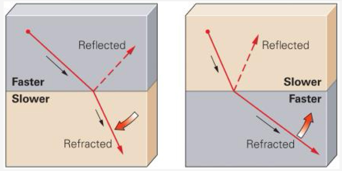
  • When a wave hits a boundary between two different materials, it may undergo refraction.

  • Refraction: waves bend as it passes through the boundary, which often changes speed.
Important discoveries from seismic waves (3)

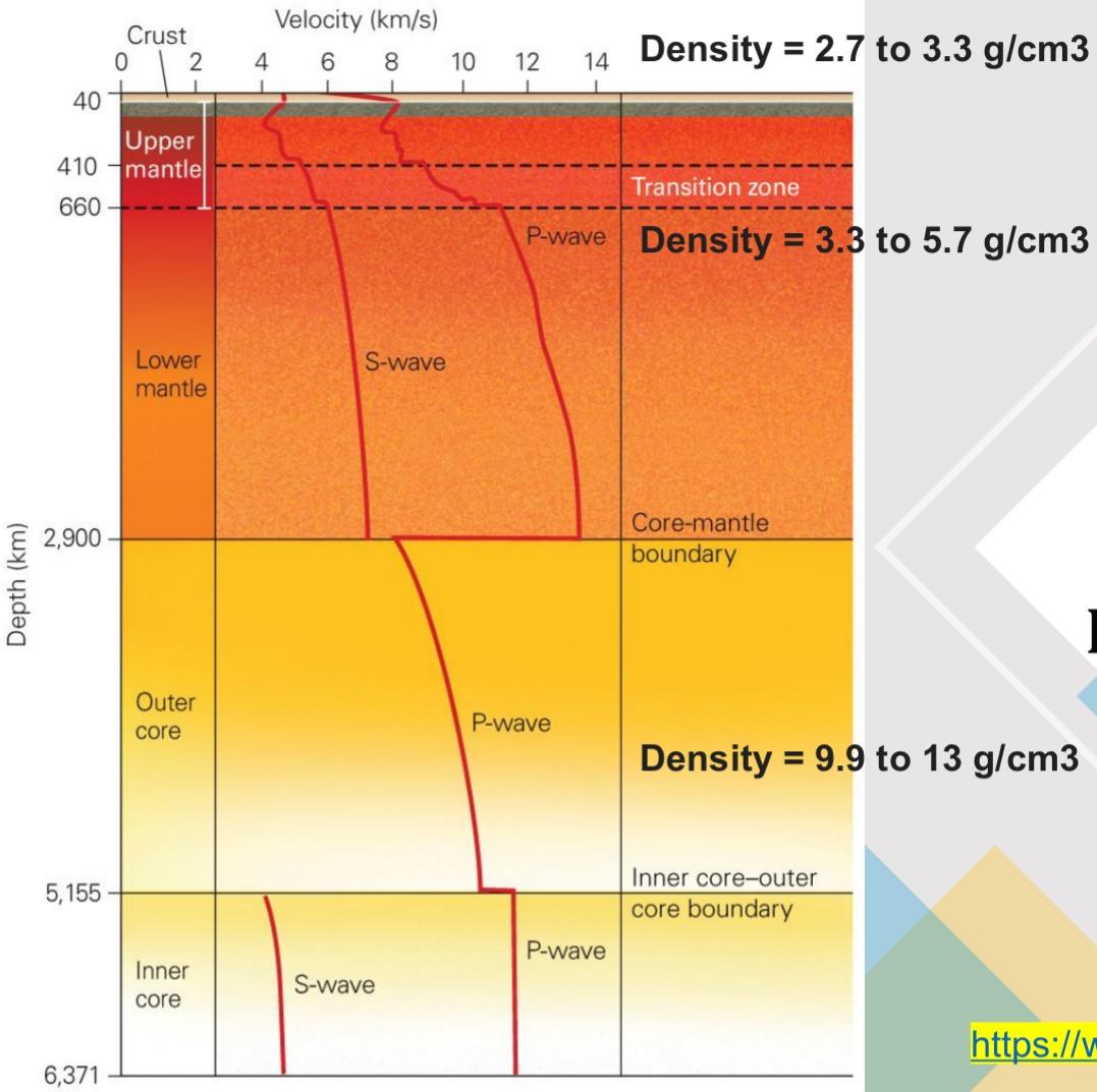
  • 3 main layers of earth: the crust, mantle (upper and lower), and the core (outer and inner).

  • Seismic waves move slower in continental crust because its made of different types of rock (granite vs. basalt).

  • P-waves pass through liquid and solid, S-waves only pass through solid.

  • The outer core is molten liquid.

  • Asthenosphere: the layer in the mantle beneath the ocean that is partially molted.

    • Where waves travel slower than in more shallow areas.

    • Low velocity zone

  • Mohorovicic discontinuity (Moho): a distinct boundary between the crust and the mantle where seismic waves are refracted.

Structure of upper mantle from waves (5)

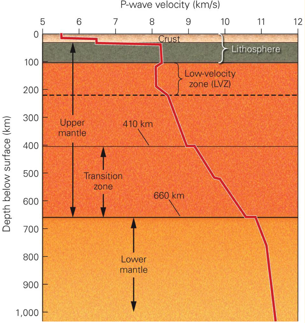
  • The boundary between crust and mantle is distinguished by a jump in seismic wave velocity (the Moho)

  • Low-velocity zone (LVZ) occurs beneath the crust (from 100-200 km) - the asthenosphere

    • P- and S- waves slow down is the asthenosphere.

  • Below LVZ, seismic-wave velocity increases with depth.

    • Upper mantle (220-660 km)

    • Transition zone (410-660 km)

    • Lower mantle (660-2900 km)

Why shadow zones happen (6)

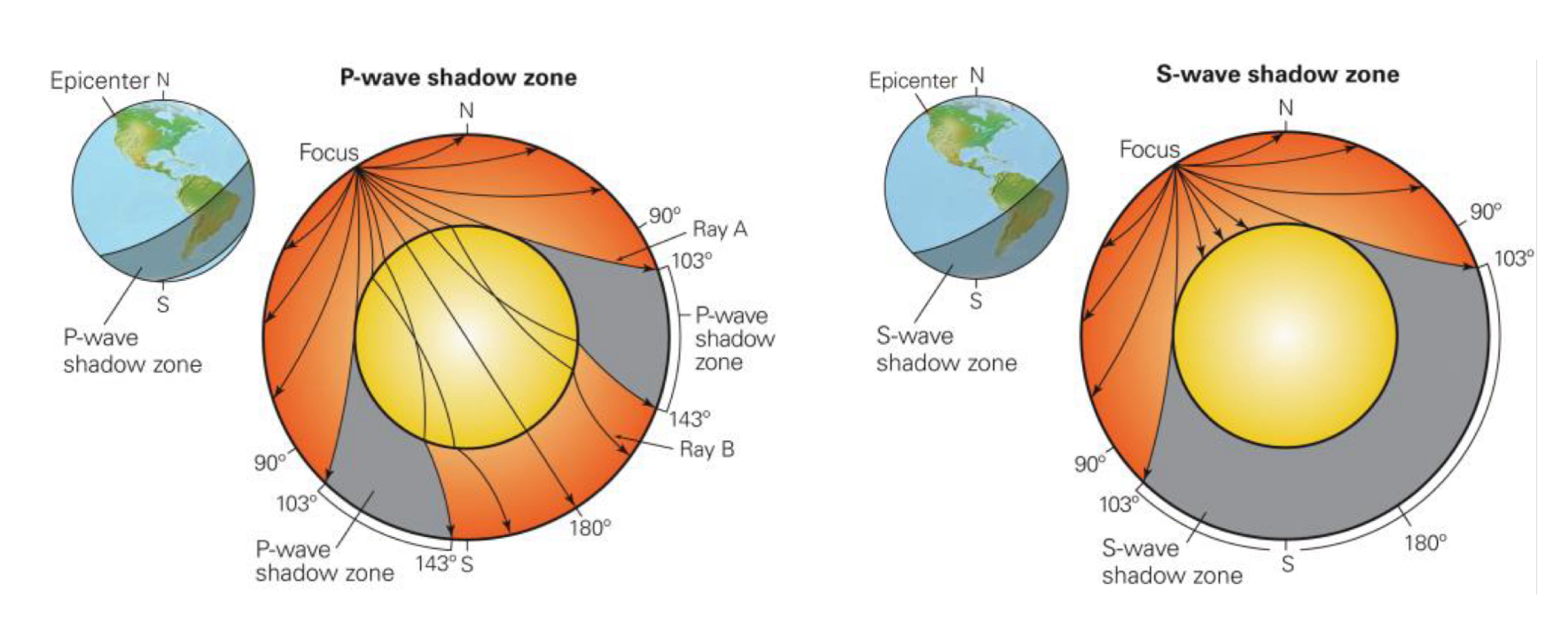
  • Liquid outer core, solid inner core

  • P-wave shadow zone

    • P-waves do not arrive at seismometers between 103° and 143° from the epicenter, due to refraction of waves entering a material that slows their velocity.

    • P-waves reflect off a boundary within the core.

  • S-wave shadow zone

    • S-waves do not arrive at seismometers between 103° and 180°

    • S-waves do not travel through liquids

  • Exact depth of inner core determined later by seismic waves created during nuclear explosions.
Structure of the core from waves (7)
Alfred Wegener and continental drift (16)

  • German meteorologist

  • Hypothesized that continents used to fit together as a supercontinent (Pangea)

Evidence to support continental drift (17-20)

  • Continents seems to fit together

  • Climatic belts - horizontal bands of different climates that surround the Earth

  • Matching geologic units

  • Distribution of fossils

Age of the seafloor (28)

  • Deep ocean cores reveal that as you move away from the mid-ocean ridge, the ocean floor becomes older.

Earthquakes and plate boundaries (29)
Paleomagnetism related to seafloor spreading stripes (31, 34, 35)

  • Paleomagnetism: studies how the Earth's magnetic field is recorded in rocks, helping us understand past tectonic movements and changes in the magnetic field over time.

  • Iron minerals within rocks preserve a record of the magnetic field present during their formation.

  • As magma solidifies, iron-bearing minerals align with Earth's magnetic field, preserving a magnetic signature in the rock.

  • A timeline of magnetic reversals over the past 4 million years shows varying lengths of time for normal and reverse magnetic polarity.

  • Magnetometers towed by ships moving perpendicular to the mid-ocean ridges recorded alternating strong and weak magnetic fields.

  • Positive (strong) and negative (weak) magnetic anomalies lined up to form “stripes” on the ocean floor. These stripes are symmetric around the mid-ocean ridge.
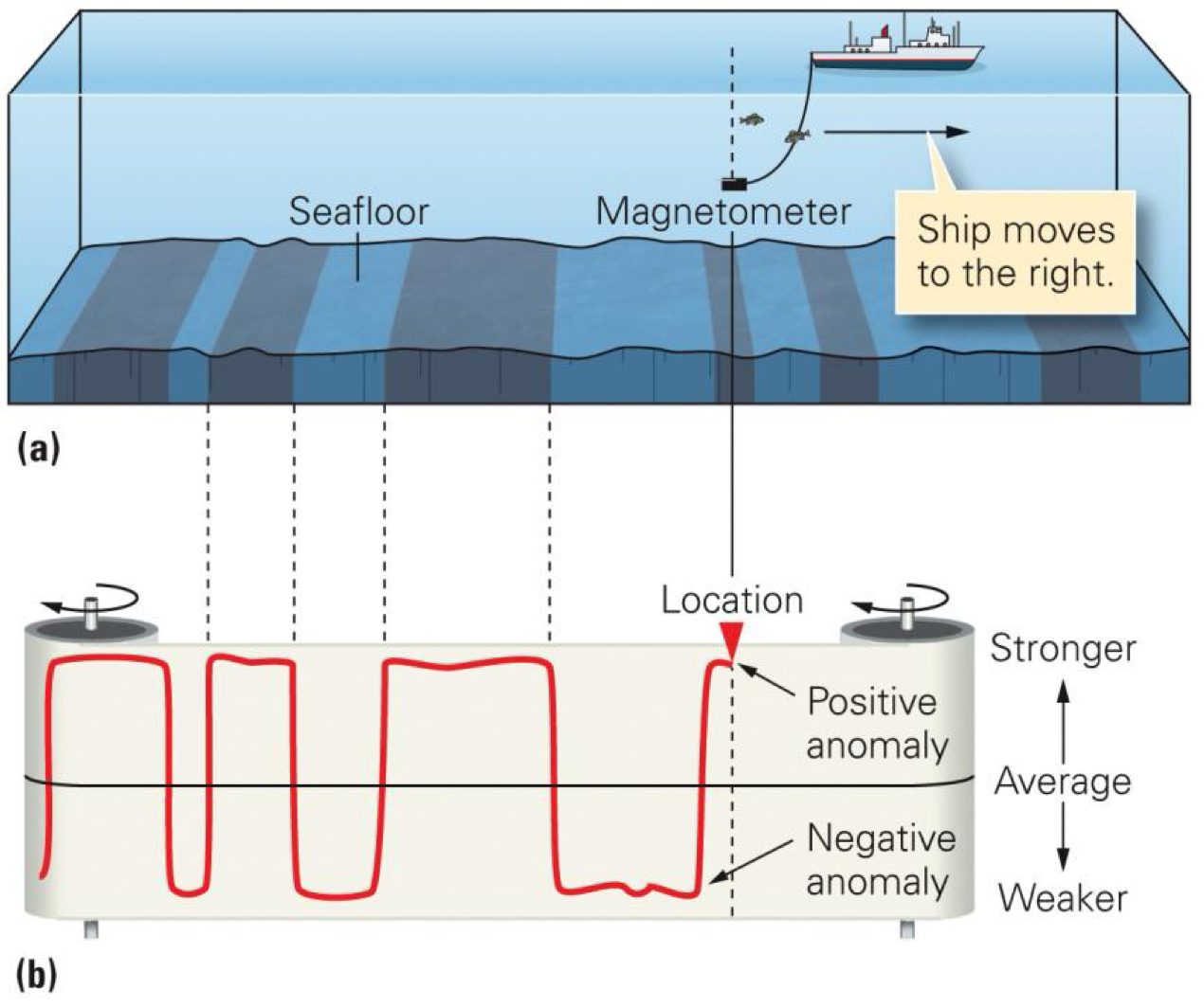
Plate tectonics is the unifying theory (40)
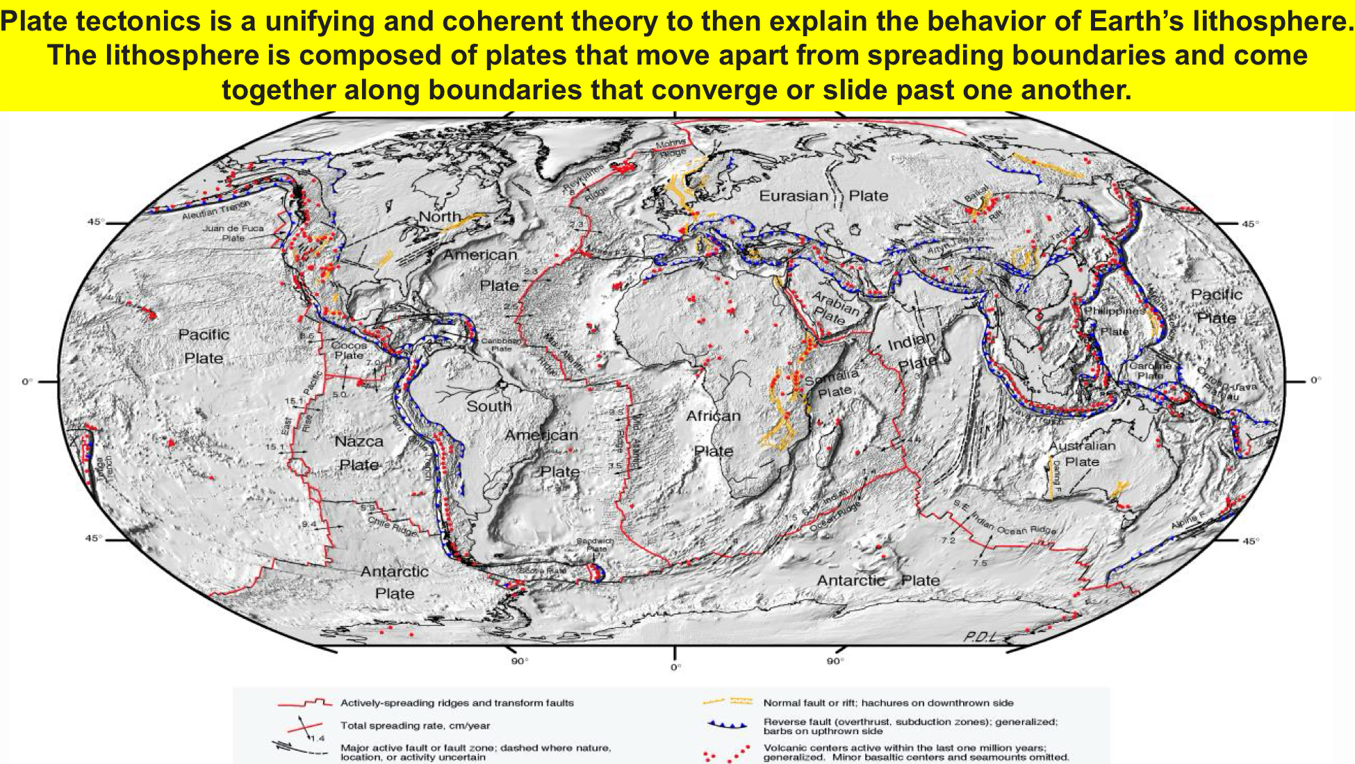
Earth’s plate boundaries and ocean vs. continental crust (do not need to memorize plate names) (44, 45)
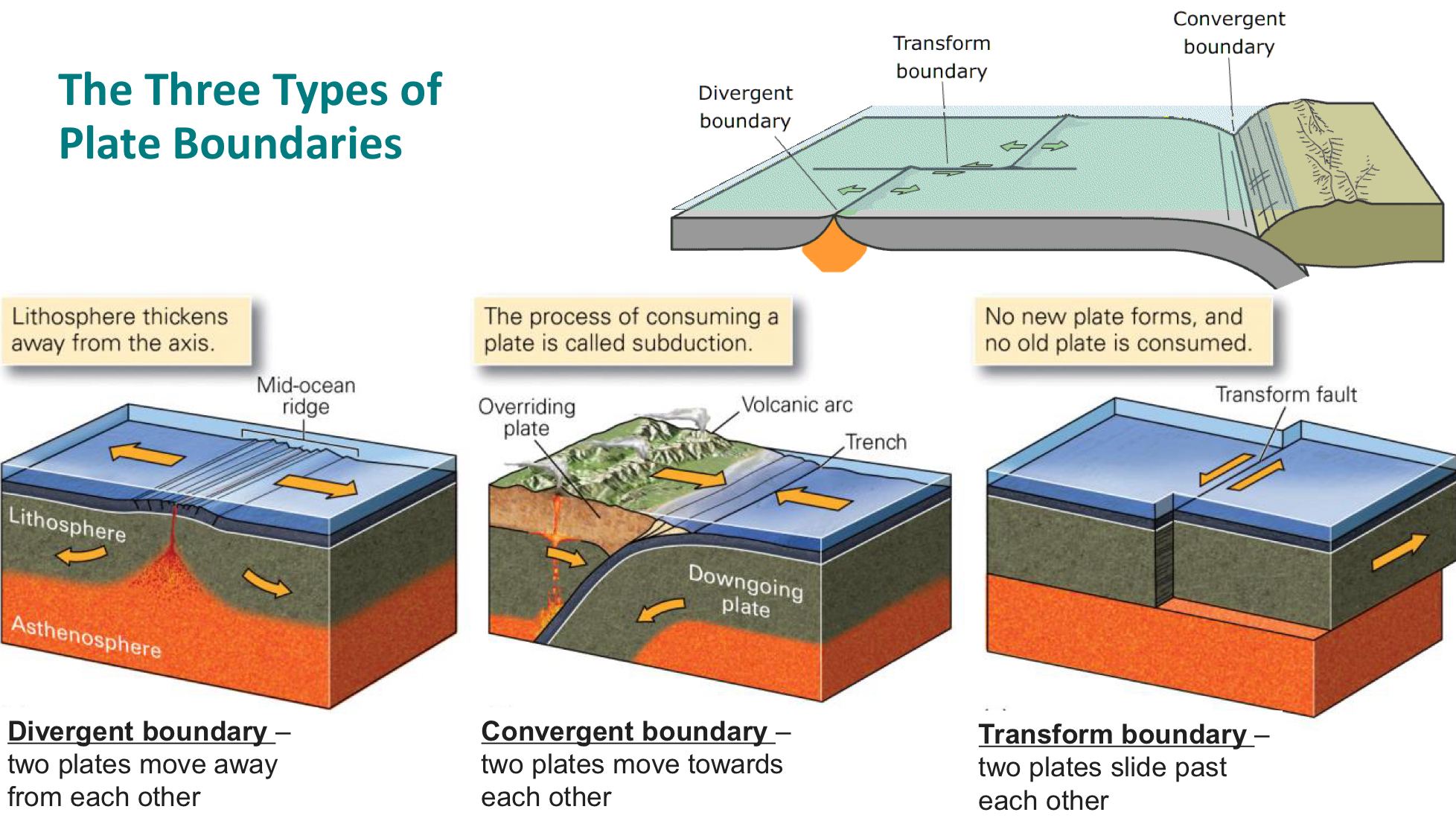
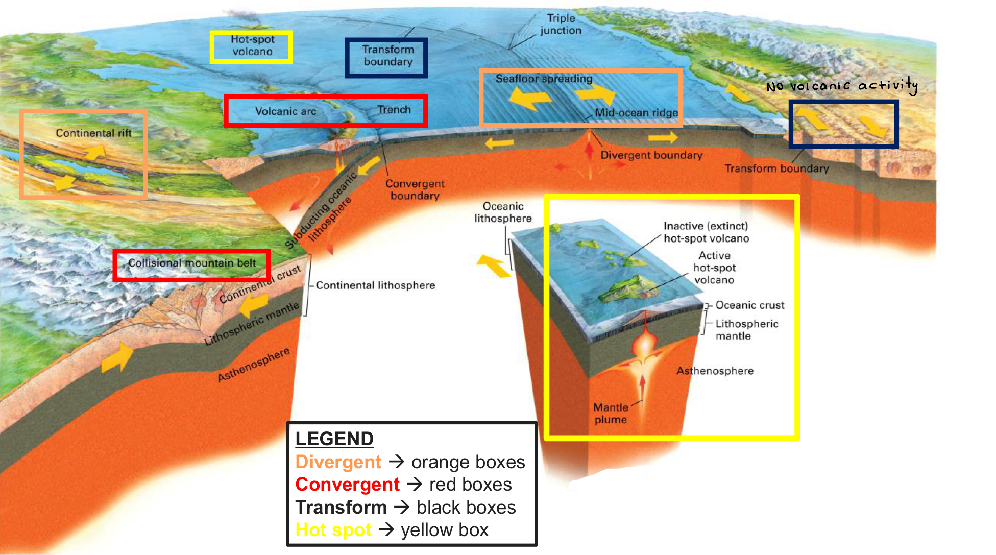
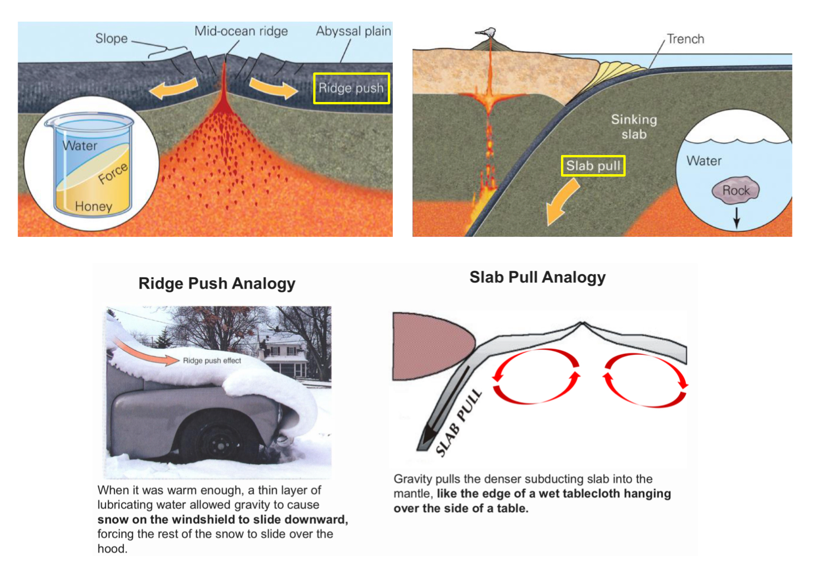
The 3 forces driving plate movement (46, 47)

  • Ridge push: develops because of the gravitational energy associated with the topographic elevation of the mid-ocean ridge.

  • Slab pull: develops because old oceanic lithosphere is denser than the underlying asthenosphere, so it sinks.
Class discussion

  • How does plate tectonics explain

    • Basalt?

      • Divergent mid-ocean ridges

      • Decompressional partial melting

      • Igneous

      • Hazards: effesive volcanism

    • Andesite?

      • Convergent subduction zones

      • Flux partial melting

      • Igneous

      • Hazards: Explosive volcanism

    • Granite?

      • Convergent volcanic arc

      • Heat transfer

      • Igneous

      • Hazard: Explosive volcanism

    • Sedimentary rocks?

      • Orogenesis lifts crust

      • Erosion breaks down crust

    • Metamorphic rocks

      • Plate tectonics leads to subduction zones and diffusion

      • Friction and intrusion

    • Climate?

      • Causes volcanoes and mountains to form and these can also contribute to a change in climate.

    • Life?

      • Plate tectonics allows heat from Earth's interior to escape to the surface, forming continents and other geological features necessary for life to emerge.

  • Will tectonism ever stop? No


Chapter 11 - Biography of Earth

Eons and Eras

  • Hadean → Archean → Proterozoic → Phanerozoic

  • Eras of Phanerozoic

    • Paleozoic → Mesozoic → Cenozoic

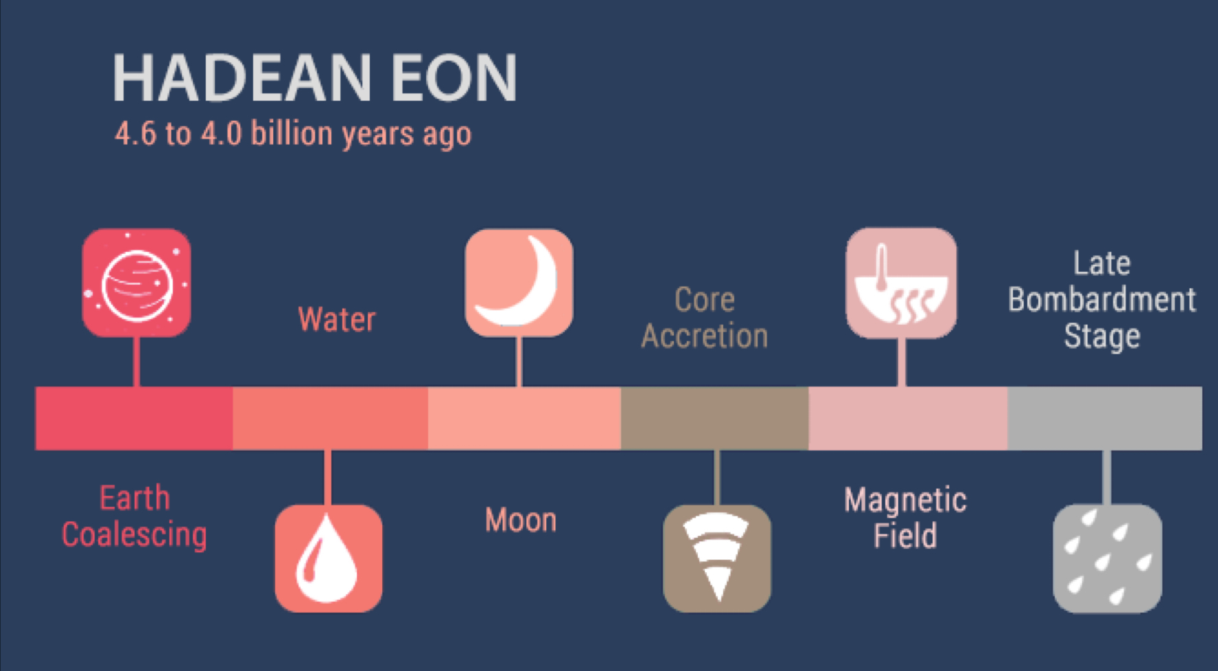
Major events of the Hadean (4)
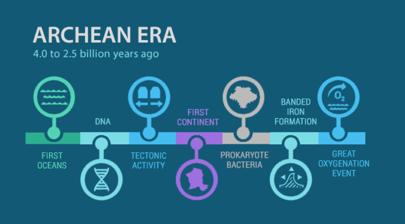
Major events of the Archean (9)
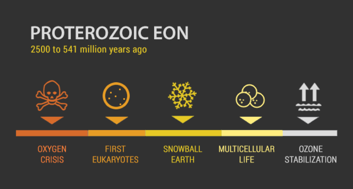
Major events of the Proterozoic (16)
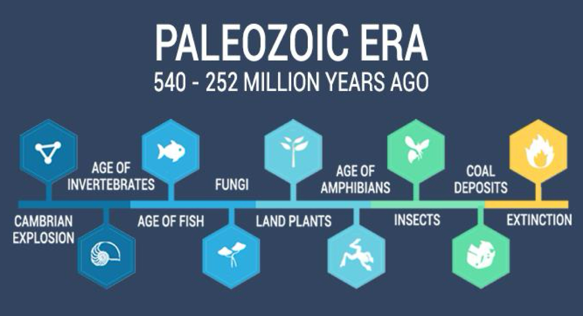
Major events of the Paleozoic (Age of fishes) and ends in a mass extinction (25)

  • Extinction (Permian extinction, largest of all extinctions)
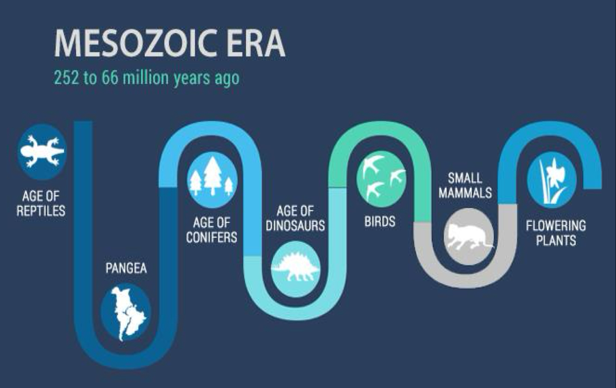
Major events of the Mesozoic (Age of dinos) and ends in a mass extinction (38)
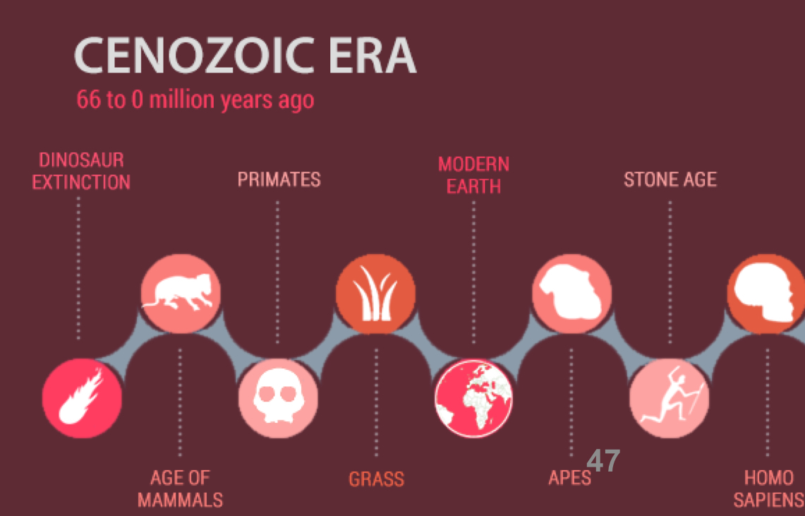
Major events of the Cenozoic (Age of mammals) (47)
Human evolution (54)

  • The Pleistocene: the time which Homo sapients evolve

  • Most megafauna went extinct

  • The Holocene: an interglacial period where human began to widely modify the landscape.

    • Follows the Pleistocene period

  • We now live in the Anthropocene - defined by humans overwhelming impact on climate and the environment.

Future Earth (55)

  • Supercontinent Amasia - 200 million years from now


Major Events to Consider

When and how the magnetosphere formed

  • The Hadean Eon, 4.54 Ga

  • Differentiation formed Earth’s layers.

  • Dense elements were toward the core.

  • A solid inner core and liquid outer core could generate Earth’s magnetosphere.

When and how the ozone formed

  • 2.4-2.2 Ga

  • Oxygens formed to create O3

  • It built up in the stratosphere and created Earth’s ozone layer.

  • The magnetosphere and ozone then provided protection for life to evolve

What caused the Great Oxygenation Event (O2)

  • O2 went up because of cyanobacteria (blue-green algae) proliferation.

  • The cyanobacteria threatened their own existence through their own waste oxygen, choking out what had been very high carbon dioxide concentrations.

What caused Snowball Earth

  • As atmosphere was oxygenated, greenhouse gas levels were diluted.

  • Earth was covered in sea ice and glaciers about 33° latitude (tipping point).

  • Land was barren rock, chemical weathering, then as continental glaciers and sea ice grew, solar insolation was reflected and continued global cooling.

Paleozoic explosion of multicellular life which leads to development of first vertebrates, organisms colonize land (forests and amphibians) and ends with massive volcanism in the Permian leading to a mass extinction

  • Mesozoic life recovers to diversity dinos and ends with Cretaceous-Paleogene mass extinction.

  • Cenozoic life recovers to diversity mammals, towards the end leads into the Pleistocene Ice Ages, humans evolve and disperse across the planet.

S

GEOL 101 Exam Review 3

Chapter 9 - Geologic Structures

Cratons and shields (4)

  • Craton: very old, strong, and stable continental crust. The oldest rocks on Earth.

  • Two cratonic provinces

    • Shields: consist of Precambrian igneous and metamorphic rocks, exposed at the surface.

    • Platforms: sedimentary cover that is draped over Precambrian shield basement rock.

Plate interactions and the 4 types of orogenesis (7-11)

  • Orogenesis: the process of mountain formation.

  • Convergence→←: mountains form where new crust has been added onto the craton.

    • Oceanic to continental collisions: subduction and exotic terranes

    • 1. Subduction

      • Subduction-related continental volcanic arc forms on the overriding plate. Accretionary prisms thicken laterally and grow upward. A fold-thrust belt develops landward of the orogen.

      • Uplift takes place because

        • 1. Compression shortens and thickens the crust

        • 2. Addition of plutons below the surface

        • 3. Volcanic material added at the surface

    • 2. Accretion of exotic terranes

      • Exotic terranes consist of island fragments of continental crust that has a separate geologic history before being sutured to the overriding plate at a convergent margin.

      • Western North America is an amalgamation of exotic terranes

    • 3. Continental to continental collisions convergence

      • When continents collide, ocean basins close and oceanic crust is pushed beneath continental crust. This action brings two pieces of continental crust together. Because continental crust is too light to sink into the Earth's mantle, it stops the process of subduction.

      • The center of the belt consists of high-grade metamorphic rocks. Fold thrust belts extend outward on either side.

      • Uplift takes place because collision leads to crustal thickening due to thrust faulting and flow folding.

  • Divergence←→: mountains also form where crust has been ripped apart from it.

    • 4. Continental rifting

      • Normal faulting in continental rifts create fault-block mountains and basins.

      • Thinning crust results in decompressional melting, which adds volcanic mountains, increases heat flow, and expands and uplifts rocks.

Types of deformation (22)

  • Rotation (tilting): change in spatial orientation by tilting.

  • Displacement (fracturing): change in location by fracturing.

    • Jointing

    • Faulting

  • Distortion (folding): change in shape by folding.

  • Brittle (shallow in crust):

    • Occurs at low temperature and pressure conditions.

    • Causes rock to break by fracturing.

    • Can occur by quick movements.

    • Displacement and rotation.

  • Ductile (deep in crust):

    • Occurs at higher temperature and pressure conditions.

    • Causes rock to deform by flowing and folding.

Stress leads to strain (24-27)

  • Stress: the force applied across a unit area.

    • A large force per area results in more deformation.

    • A small force per area results in little deformation.

    • If equal force were applied to small and large areas, the small area would deform more.

  • Strain: a change in shape or volume in response to a stress.

  • Stress is the cause, strain is the effect.

  • Compression, tension, and shear:

  • If the stress is compression, then the strain would be shortening.

    • Compression takes place when an object is squeezed.

    • Deformation shortens and thickens the crust.

      • Can fold, fault, or tilt rocks and leads to mountain building.

  • If the stress is tension, then strain would be elongation.

    • Tension occurs when the ends of an object are pulled apart.

    • Deformation lengthens and thins the crust.

      • Can fault, or tilt rocks and leads to crustal thinning and rifting.

  • If the stress is shear, then strain would be shear.

    • Shear develops when surfaces slide parallel but opposite past one another.

    • Deformation neither thickens or thins the crust.

      • Can fault rocks and leads to plate slippage.

Fault definition

  • Faults: planar breaks in the crust that show displacement.

    • Micro to macro in scale.

  • Types of faults are classified by their relative motion and geometry (vertical, horizontal, or dipping).

  • Dip-slip faults: characterized by blocks that move parallel to the dip of the fault (vertical).

Dip-slip: Normal fault and example (33)

  • Normal fault: hanging wall moves down relative to footwall.

  • Brittle - tensional stress, like in regions experiencing crustal extension.

  • Example: Basin and Range

  • Death Valley

Dip-Slip Reverse/thrust faults and example (34, 35)

  • Reverse fault: hanging wall moves up relative to the footwall - high angle > 30°

  • Brittle - compressional stress, like in regions experiencing convergence.

  • Death Valley

  • Thrust fault: a type of reverse fault but with a low angle dip, < 30°.

  • Brittle - compressional stress, like convergence creating large mountain belts.

  • Las Vegas, Keystone Thrust

Strike-slip fault and example (36)

  • Strike-slip faults: when blocks move parallel to the fault plane strike. Tend to be vertical.

  • Right lateral strike-slip fault: fault block appears to move sideways and to the right past the observer’s block.

    • Only horizontal movement.

    • No large vertical motion across the fault.

    • California, San Andreas Fault

  • Left lateral strike-slip fault: fault block appears to move sideways and to the left past the observer’s block.

    • No large vertical motion across the fault.

    • California, Garlock Fault

Folds

  • Folds: occur where rock has been deformed deep below the surface from tectonic compression (continental to continental convergent boundaries).

  • Folds can form in a variety of shapes, sizes, and geometries (slide 53).

  • Orogenic settings produce large volumes of folded rock.

  • Rock must be hot or under pressure to move in a plastic manner.

  • Compression acts differently on:

    • Thin vs. thick layers

    • Crystalline vs. clastic layers

Anticlinal fold and Synclinal fold (54-55)

  • Anticline fold: a fold that looks like an arch. The limbs dip out and away from the hinge.

  • Syncline fold: a fold that opens upward like a trough. The limbs dip inward and toward the hinge.

Practice identifying structures (61, 62)

  • Dome: a fold with the appearance of an overturned bowl, exposes older rock in the center.

  • Basin: a fold shaped like an upright bowl, exposes younger rocks in the center.

Stress review (63)

Class Questions:

  • When erosion exceeds the rate of uplift, a mountain will appear to be reduced in elevation.

  • The type of deformation that takes place depends on temperature, pressure, rate of deformation, and amount of force.


Chapter 8 - Earthquakes

Frequency of earthquakes (4)

  • Common, thousands of small earthquakes everyday (<3.0)

    • More than a million detectable earthquakes a year.

  • Several hundred large earthquakes occur each year (3.0 to <8.0)

    • Very large ones occur much less frequent, 1 a year, or less (8.0 to <10.0)

Location of earthquakes along plate boundaries and depth (10-13)

  • Earthquakes at plate boundaries

    • Shallow: divergent and transform

      • Occurs within the top 60 km of the crust.

    • Intermediate and deep: convergent

      • Intermediate occurs between 60-300 km depth.

      • Deep occurs between 300-660 km depth.

  • Divergent Plate Boundaries

    • Mid Ocean Ridges (MORS)

      • Two types of faulting typify MORS; normal faults at the spreading ridge axis and strike-slip faults along the transforms.

      • MOR earthquakes are shallow (<10 km deep) and generally low energy.

    • Continental Rift Zones

      • Continental rifts occur where tension and stretching creates normal faults.

      • Rifting generates shallow earthquakes, as well, except these normal faults are on land so impact structures and people.

        • Examples: Basic and Range Province, Rio Grande Rift (New Mexico, East African Rift

  • Transform Plate Boundaries

    • Large continental transform earthquakes happen in the shallow crust often cause major disasters.

    • The San Andreas Fault runs through western California, where the Pacific plate moves north and the North American plate moves south.

    • The San Andreas Fault is highly active, with hundreds of earthquakes each year, moving at a rate of 6cm/year.

  • Convergent Plate Boundaries

    • Convergent plate boundaries have shallow, intermediate, and deep earthquakes.

    • Normal faults form where the down going slab bends the overriding plate downward.

    • Large thrust faults occur at the contact between plates when the overriding plate can snap back, creating a huge megathrust earthquake → these can cause tsunamis.

    • Earthquakes are rare below 660 km as mantle is too ductile.

Seismic waves, body vs. surface waves (20, 21)

  • Seismic waves: waves of energy generated when rock in the crust breaks; causes shaking during earthquakes.

  • Earthquakes produce waves of energy which arrive in a distinct sequence and with distinct motion.

    • Body waves: (P-waves and S-waves)

    • Surface waves (L-waves and R-waves)

  • Energy releases moves in all directions, like ripples in a pond.

  • Body waves: in earth’s interior they lose their amplitude rapidly as they get farther from the earthquakes because they spread out inside the volume of the earth.

  • Ability for seismic waves to travels through material depends on the type of material and the rock type.

    • Highly fractured rock and crushed material absorbs more seismic energy.

    • More compact or crystalline material allows seismic waves to transfer faster.

  • Seismic waves travel faster through solids.

  • S-waves can’t travel through liquids.

Class Question (22)

  • Suppose you are buying a house in an earthquake-prone area. What option is likely to stay safe during an earthquake?

    • A house in the Sierras of California, built on granite (its built on solid bedrock).

Type, speed, and level of damage of seismic waves (24-27, 31)

  • P-waves: fastest seismic waves that can travel through solids, liquids, and gases.

    • Compressional waves travel in the same direction that the waves move.

      • Material is compressed and expanded as the wave passes through it.

      • Produced rapid, bucking, up and down motion.

    • Moves about 4-7 km/s

  • S-waves: travels perpendicular to wave movement.

    • Shear waves

    • Back and forth motion, higher in amplitude

    • Stronger than P-waves, cause extensive damage.

    • Arrives second

    • Travels through solids only.

    • Travels about 2-5 km/s

  • L-waves: surface waves that travel along Earth’s exterior.

    • Love waves

    • Slowest, arrives third, follow quickly behind S-waves

    • Most destructive.

    • L-waves are S-waves that intersect the land surface.

    • Move the ground back and forth like writhing snake.

  • R-waves: P-waves that intersect the land surface.

    • Rayleigh waves

    • Last to arrive

    • Cause ground to ripple up and down like water and ripples

    • Last longer that other waves

    • Cause extensive damage

Earthquake magnitude (38)

  • Magnitude scales: logarithmic, each step up represent 10x more ground motion (maximum amplitude).

  • Magnitude is related to the energy released.

  • Each step up represents an increase of 32x more energy.

  • Magnitude scales examples:

    • Richter scale: best near epicenter

    • Moment magnitude scale: most accurate and considers rock strength, surface area of fault rupture, and amount of movement.

Types of damage from earthquakes (40)

  • Infrastructure damages: buildings, bridges, and roads break or collapse.

  • Landslides and avalanches: shaking causes material on steep slopes to fail.

  • Liquefaction: shallow saturation turns sediment to quicksand.

  • Fire: most common, shaking topples stoves, candles, power lines, and breaks gas mains.

  • Tsunamis: displacement of the sea floor by an earthquake creates mega-waves.

Major earthquakes and their related damages because of location (42, 45, 46)

  • San Francisco (1906)

    • Strike-slip fault, rupture seam was 430 km long x 15 km deep (6,500 km² of slippage)

    • Horizontal displacement was 15 feet with a visible scar 280 miles long.

    • Magnitude: 7.9

    • San Andreas Fault

    • Most damage caused by fire

  • Nepal (2015)

    • Compression from northward push of the Indian subcontinent into southern Asia.

    • Magnitude: 7.8

    • Aftershock: 6.6

    • 7,000 km² section of a thrust fault.

    • Displacement up to 3 m (9.8 ft)

    • Causes entire towns to collapse

    • Triggered landslides and avalanches throughout the Himalayas (including Mt. Everest)

  • Sumatra megathrust (2004)

    • Megathrust earthquake in subduction trench off northwest Sumatra

    • 3rd largest earthquakes ever recorded

    • Magnitude: 9.1

    • Displacement: 15 m and fault ruptured 1,500 km along the trench, over 22,000 km² of total displacement.

    • Caused entire planet to vibrate up to 1 centimeter.

    • Caused smaller earthquakes in other parts of the world.

    • Giant tsunami destroyed coastlines around the Indian Ocean. Waves 100 ft high.

      • Banda Aceh, Sumatra was hit the hardest. Tsunami erased entire communities, buildings, and people.


Chapter 2 and Interlude D - Plate Tectonics

Refraction pattern of seismic waves (2)

  • When a wave hits a boundary between two different materials, it may undergo refraction.

  • Refraction: waves bend as it passes through the boundary, which often changes speed.

Important discoveries from seismic waves (3)

  • 3 main layers of earth: the crust, mantle (upper and lower), and the core (outer and inner).

  • Seismic waves move slower in continental crust because its made of different types of rock (granite vs. basalt).

  • P-waves pass through liquid and solid, S-waves only pass through solid.

  • The outer core is molten liquid.

  • Asthenosphere: the layer in the mantle beneath the ocean that is partially molted.

    • Where waves travel slower than in more shallow areas.

    • Low velocity zone

  • Mohorovicic discontinuity (Moho): a distinct boundary between the crust and the mantle where seismic waves are refracted.

Structure of upper mantle from waves (5)

  • The boundary between crust and mantle is distinguished by a jump in seismic wave velocity (the Moho)

  • Low-velocity zone (LVZ) occurs beneath the crust (from 100-200 km) - the asthenosphere

    • P- and S- waves slow down is the asthenosphere.

  • Below LVZ, seismic-wave velocity increases with depth.

    • Upper mantle (220-660 km)

    • Transition zone (410-660 km)

    • Lower mantle (660-2900 km)

Why shadow zones happen (6)

  • Liquid outer core, solid inner core

  • P-wave shadow zone

    • P-waves do not arrive at seismometers between 103° and 143° from the epicenter, due to refraction of waves entering a material that slows their velocity.

    • P-waves reflect off a boundary within the core.

  • S-wave shadow zone

    • S-waves do not arrive at seismometers between 103° and 180°

    • S-waves do not travel through liquids

  • Exact depth of inner core determined later by seismic waves created during nuclear explosions.

Structure of the core from waves (7)

Alfred Wegener and continental drift (16)

  • German meteorologist

  • Hypothesized that continents used to fit together as a supercontinent (Pangea)

Evidence to support continental drift (17-20)

  • Continents seems to fit together

  • Climatic belts - horizontal bands of different climates that surround the Earth

  • Matching geologic units

  • Distribution of fossils

Age of the seafloor (28)

  • Deep ocean cores reveal that as you move away from the mid-ocean ridge, the ocean floor becomes older.

Earthquakes and plate boundaries (29)

Paleomagnetism related to seafloor spreading stripes (31, 34, 35)

  • Paleomagnetism: studies how the Earth's magnetic field is recorded in rocks, helping us understand past tectonic movements and changes in the magnetic field over time.

  • Iron minerals within rocks preserve a record of the magnetic field present during their formation.

  • As magma solidifies, iron-bearing minerals align with Earth's magnetic field, preserving a magnetic signature in the rock.

  • A timeline of magnetic reversals over the past 4 million years shows varying lengths of time for normal and reverse magnetic polarity.

  • Magnetometers towed by ships moving perpendicular to the mid-ocean ridges recorded alternating strong and weak magnetic fields.

  • Positive (strong) and negative (weak) magnetic anomalies lined up to form “stripes” on the ocean floor. These stripes are symmetric around the mid-ocean ridge.

Plate tectonics is the unifying theory (40)

Earth’s plate boundaries and ocean vs. continental crust (do not need to memorize plate names) (44, 45)

The 3 forces driving plate movement (46, 47)

  • Ridge push: develops because of the gravitational energy associated with the topographic elevation of the mid-ocean ridge.

  • Slab pull: develops because old oceanic lithosphere is denser than the underlying asthenosphere, so it sinks.

Class discussion

  • How does plate tectonics explain

    • Basalt?

      • Divergent mid-ocean ridges

      • Decompressional partial melting

      • Igneous

      • Hazards: effesive volcanism

    • Andesite?

      • Convergent subduction zones

      • Flux partial melting

      • Igneous

      • Hazards: Explosive volcanism

    • Granite?

      • Convergent volcanic arc

      • Heat transfer

      • Igneous

      • Hazard: Explosive volcanism

    • Sedimentary rocks?

      • Orogenesis lifts crust

      • Erosion breaks down crust

    • Metamorphic rocks

      • Plate tectonics leads to subduction zones and diffusion

      • Friction and intrusion

    • Climate?

      • Causes volcanoes and mountains to form and these can also contribute to a change in climate.

    • Life?

      • Plate tectonics allows heat from Earth's interior to escape to the surface, forming continents and other geological features necessary for life to emerge.

  • Will tectonism ever stop? No


Chapter 11 - Biography of Earth

Eons and Eras

  • Hadean → Archean → Proterozoic → Phanerozoic

  • Eras of Phanerozoic

    • Paleozoic → Mesozoic → Cenozoic

Major events of the Hadean (4)

Major events of the Archean (9)

Major events of the Proterozoic (16)

Major events of the Paleozoic (Age of fishes) and ends in a mass extinction (25)

  • Extinction (Permian extinction, largest of all extinctions)

Major events of the Mesozoic (Age of dinos) and ends in a mass extinction (38)

Major events of the Cenozoic (Age of mammals) (47)

Human evolution (54)

  • The Pleistocene: the time which Homo sapients evolve

  • Most megafauna went extinct

  • The Holocene: an interglacial period where human began to widely modify the landscape.

    • Follows the Pleistocene period

  • We now live in the Anthropocene - defined by humans overwhelming impact on climate and the environment.

Future Earth (55)

  • Supercontinent Amasia - 200 million years from now


Major Events to Consider

When and how the magnetosphere formed

  • The Hadean Eon, 4.54 Ga

  • Differentiation formed Earth’s layers.

  • Dense elements were toward the core.

  • A solid inner core and liquid outer core could generate Earth’s magnetosphere.

When and how the ozone formed

  • 2.4-2.2 Ga

  • Oxygens formed to create O3

  • It built up in the stratosphere and created Earth’s ozone layer.

  • The magnetosphere and ozone then provided protection for life to evolve

What caused the Great Oxygenation Event (O2)

  • O2 went up because of cyanobacteria (blue-green algae) proliferation.

  • The cyanobacteria threatened their own existence through their own waste oxygen, choking out what had been very high carbon dioxide concentrations.

What caused Snowball Earth

  • As atmosphere was oxygenated, greenhouse gas levels were diluted.

  • Earth was covered in sea ice and glaciers about 33° latitude (tipping point).

  • Land was barren rock, chemical weathering, then as continental glaciers and sea ice grew, solar insolation was reflected and continued global cooling.

Paleozoic explosion of multicellular life which leads to development of first vertebrates, organisms colonize land (forests and amphibians) and ends with massive volcanism in the Permian leading to a mass extinction

  • Mesozoic life recovers to diversity dinos and ends with Cretaceous-Paleogene mass extinction.

  • Cenozoic life recovers to diversity mammals, towards the end leads into the Pleistocene Ice Ages, humans evolve and disperse across the planet.

robot