Rivers
As rivers flow from their beginning to their end, they change the landscape and create features along the way.
Source - where river begins
Course - route river takes as it flows from upland area down through its valley until it enters sea
Tributary - a stream/river which joins a larger river
Mouth - place where river enters sea/lake
Estuary - where river mouth is tidal
River basin - the entire area which is drained by river and its tributaries
Watershed - the high ground that separates two river basins
The ways river change the landscape:
Erosion (wearing it away)
Transportation (moving material downstream)
Deposition (dropping the material)
Erosion Rivers erode through a number of processes:
Hydraulic action - the force of moving water erodes pieces of rock from banks and beds of river. The eroded material is transported down through river’s course and is referred to as the ‘load’.
Abrasion (also called corrasion) - the load erodes and wears away riverbed and banks, deepening and widening river channel.
Solution - river water dissolves rock particles such as particles.
Attrition - the load is also in collision with itself. Pebbles and stones rub against one another and are worn down and smoothened.
The rate of erosion depends on:
Size of river (river erodes faster when it is in flood)
Speed of river
Hardness of rock
Transportation
Transportation is the moving of the load downstream.
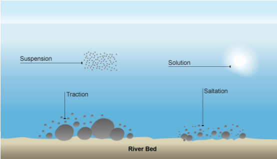
Deposition
Deposition is the dropping of the load. Rivers deposit their load when:
They lose speed
There is a reduction in waters in river channel
They flow into a lake or sea
The slop of river is reduced
The Changing River Valley
The nature of a river changes as it flows from upland down to its mouth. Three stages can be identified: youthful (upper valley), mature (middle valley) and old age (old valley).
The Features of a Youthful River
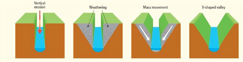
The processes of erosion in an upland area form the features of a youthful river. At this stage, the river cuts down into the rock. This process is called ‘vertical erosion’.
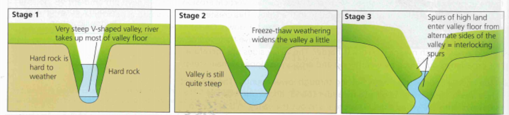
V-Shaped Valleys
These valleys have steep sides and narrow floors. It is formed by vertical erosion, which deepens the valley. The steep sides are then weathered and mass movement causes the sides to move downslope into the river. This gives the valley its ‘V-shape’.
Interlocking spurs
These are areas of high ground that jut out from each side of the valley. They seem to interlock rather like pieces of a jigsaw. If the river meets an area of hard rock, it is unable to cut through it. Instead the river flows around it while still eroding downwards. This results in a series of interlocking spurs.
Potholes
These are circular-shaped hollows found on the riverbed. When the riverbed is uneven, the water begins to swirl around. Pebbles that are carried by the swirling water cut down into the riverbed and create hollows, known as potholes. This is the process of abrasion.
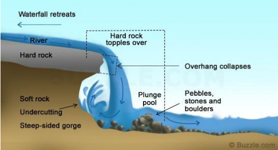
Waterfalls
Waterfalls are created where a layer of hard rock lies over a layer of soft rock.
When the water flows down the slope, the soft rock erodes faster than the hard rock.
The soft rock is worn away underneath the hard rock creating an overhang.
The water now falls rather than flows and the force of the falling water creates a plunge pool.
Example of waterfall is Torc Waterfall (Killarney)
The Features of a Mature River
The river is much bigger at the mature stage as many tributaries have joined it. There is still some vertical erosion, but here the valley is also widened by sideways erosion.
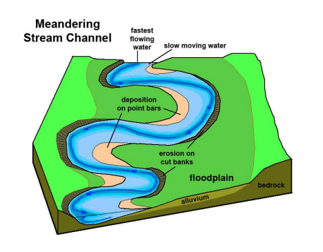
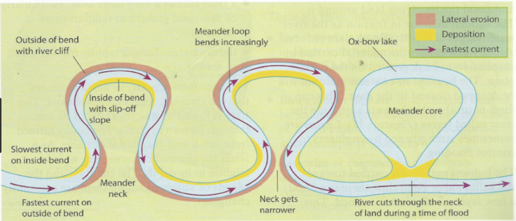
Meanders
Meanders are bends that are found along the mature course of the river. Meanders are formed by a combination of lateral (sideways) erosion and deposition.
The water on the outer bend of a meander is deeper and flows more quickly. The river has more erosive power.
The water on the inner bend is shallow and flows more slowly. At this point, deposition occurs, as the river does not have the ability to carry load any further.
Over time, they become more and more pronounced
The Features of an Old River
At the old stage, the river is slowly flowing over low-lying ground, which is almost level. This means that the river has very little energy to erode. The river uses its energy to transport the load. When the load gets too heavy to carry, deposition will occur.
Oxbow lakes
Oxbow lakes are horseshoe-shaped lakes. These are formed when a meander is cut off from the river. The neck of land between the meander loops becomes narrower and even more pronounced because of erosion.
Eventually, during a time of flood, the river will cut across the narrow neck.
The river at the cut off point has very little energy and deposits its load.
These deposits eventually seal off both ends of the meander, forming an oxbow lake.
Flood Plains
These are relatively flat areas of land on either side of an old river.
When a river burst its banks and floods the surrounding land, the water quickly loses its speed and deposits a layer of fine, fertile soil, called alluvium, which is rich in minerals. After many periods of flooding and further deposition, a thick covering of fertile land known as a flood plain is created.
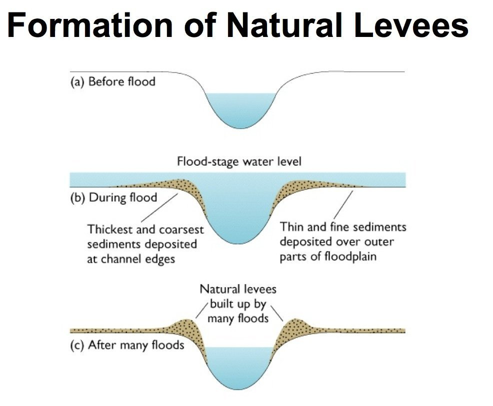
Levees
These are raised banks found alongside a river at its old stage.
When the river is in flood and spreads out over the flood plain, it deposits its load of rich alluvium.
It drops the larger particles close to the edge of the river and transports the lighter, smaller particles further away.
These larger particles gradually build up to form a levee.
An example of a levee is at the old stage of the River Liffey.
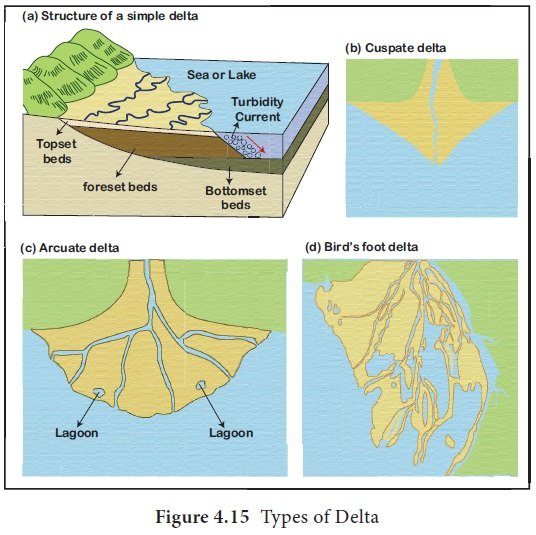
A delta is a triangular area of land formed when a river deposits its load as it flows into a lake or sea.
Rivers and People
Examples of human interaction with rivers include:
Hydroelectric power stations (HEP station)
Settlement
Transport
Industry
Tourism and leisure
Dams
Dams are built across rivers and have positive and negative effects.
Positive effects
HEP stations can be built near dams to use energy from rushing water to generate electricity
Reservoirs form behind dam and these can be used to provide urban water supplies
Reservoir lakes can be used for leisure activities like water sport.
Negative effects
Can affect spawning grounds of fish and it can affect fish farming
May involve movement of people from their homes
May also mean loss of good agricultural land due to flooding
Other Uses of Rivers
Rivers provide many positive opportunities for humans:
Sites for settlement
Natural route ways for transportation
Provide us with rich agricultural land
Used for leisure pursuits (rowing)
They can also bring negative effects:
Can become polluted from sewage
Can flood causing devastation to farmland and property
Case Study
Mallow Flooding
· River Blackwater, Cork
· Records of flooding from 1628
· Common occurrence