Unit 4 Test
Weathering and Soil
Upco Notes Pages 130-135 and 138
Weathering- the chemical and physical breakdown of rocks on or at the Earth’s surface into smaller fragments.
Weathering is the preparation for erosion
Erosion- the movement of weathered material from one place to another.
Response to the effect of the environment on Earth’s crust
Weathering agents- Change the physical and/or chemical characteristics of the rocks.
Climate is the most important factor in the weathering process
Weathering Types
The two types of weathering are physical and chemical
Physical weathering
Physical weathering- occurs when a rock is cracked, split, or broken into smaller pieces called sediments.
No change in rock composition
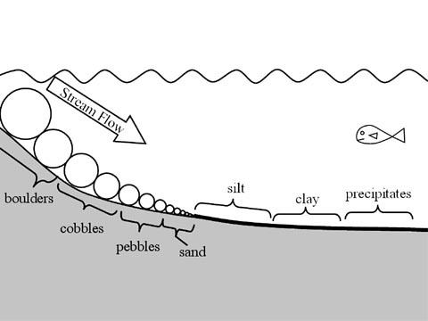
Sediments- Classified by size as boulders, cobbles, pebbles, sand, silt, clays, and dissolved particles.
Frost action- The breakup of rocks caused by alternate freezing and thawing of water.
Water condenses or seeps into the smaller cracks or spaces in rock as well as larger openings is more porous than before
Repeated freezing and expanding of water in these spaces will cause the rock to crumble
Abrasion- Physical wearing down of rocks as they trub or bounce against each other. Water or wind or gravity pick up other rocks
Mostly in dry windy areas, ex; under glaciers, stream channels
Exfoliation- Peeling away large sheets of loosened material at the surface of a rock.
Root wedging- Large shrubs grow through cracks in boulders may break the rock apart.
Chemical weathering
Chemical weathering- occurs when a rock is broken down by chemical action resulting in a change in the composition of the rock.
Agents Oxygen, rainwater, carbon dioxide, and acids produced by decaying plants and animals.
Oxidation- Occurs when oxygen unites chemically with minerals
Ex; When oxygen combines with iron, rust (iron oxide) is formed
Looks different in different types of rocks.
Hydration- when waters unite chemically with minerals.
Certain minerals such as hornblende and feldspar unite with water, they crumble into small particles of clay
Carbonation- when carbon dioxide unites chemically with minerals.
When carbon dioxide is dissolved in water, it forms weak carbonic acid
Carbon acid readily dissolves large masses of limestone, creating caves, caverns, and other structures in the bedrock
Acid Precipitation- Comes from acids mixed with rain or snow
Ex: Burning fossils fuels
Groundwater- Contains weak acids which dissolve some kinds of rocks
Sinkholes- Saucer shaped holes in the surface of the land are left when carbonic acid dissolves limestone in the ground.
Karst topography- A limestone area pitted with sinkholes
Stalactites- Limestone deposits on the ceiling and floor.
Icicle shaped
“C” Ceiling
Stalagmites- Deposits which “grow up” from the ground
“G” ground
Organic decay- occurs when acids, which are formed when plants and animals decay, dissolves in water
Soil- the part of the weathered regolith in which rooted plants will grow. It is composed primarily of particles of rocks, minerals, and organic matter, and consists of all three states of matter. Solid, sand and clay make up the bulk of the soil while minerals and decayed organic matter supply it with nutrients. Liquid water allows the chemical actions necessary to produce a mature soil. Air and the gases, oxygen and nitrogen, present mainly in solution, provide the soil with nutrients and increase the weathering processes in the soil.
Particle size- The weathering rate of rock material varies inversely with particle size.
The smaller the particles the greater the weathering rate
Larger solid pieces of rock weather more slowly than smaller and loose pieces of the same rock
Mineral Composition- Rock particles weather at different rates depending on their mineral composition.
Hard rocks= slower weathering
Soft rocks= faster weathering
Abrasion- the grinding and bumping of one rock against another.
Transported sediment- Rock material that has been transported from its place of origin to another location.
Residual sediment- Rock material that has weathered and remained in its place of origin.
Transporting agents- Forces which move sediments from one place to another.
Mass movement- When the Earth moves downslope under the influence of gravity.
Gravity- Primary Driving force behind all transporting (erosional) systems.
Soil Profile- As soils mature they grow richer, developing a series of layers called soil profile. Each layer has a different texture, colors, and composition
Topsoil- The top layer of the soil
Most organic matter
Best for growing plants
Subsoil- Under the topsoil
Rich in clay sized particles
Running Water
UPCO Pages 137-141 143-146
Erosion- The transportation of loose sediments or rocks produced by weathering.
Major agents include; gravity, running water, glaciers, wind, and waves.
Transported sediments- Rock material that has been transported from its place of origin to another location.
More common than residual.
Residual sediment- Rock material that has been weathered and remained in its place of origin.
Abrasion- The grinding and bumping of one rock against another.
Tauls- Angular deposits of broken rock along the base of a cliff.
-------------------------------------------------------------------------------------------
Transporting Agents
Transporting Agents- Forces which move sediments from one place to another.
Gravity- The primary force behind all transporting (erosional) systems.
Provide the agent with enough kinetic energy to transport sediments.
Running water- The primary agent of erosion on Earth.
Most running water is found in streams or rivers.
Stream- Any running water forms a stream.
Sediments transported by streams tend to become round as a result of abrasion.
Features include; V-shaped valleys, deltas, flood plains, and meanders.
Watershed- The area drained by a stream and its tributaries.
Carrying Power- The ability of a stream to move particles of different size
The greater the stream’s carrying power, the larger the size it can carry.
The carrying power of a stream depends mainly on the velocity of the stream.
Stream Velocity- The average velocity (speed) of a stream depends on stream discharge and gradient.
Stream Discharge- The volume of water in the stream.
Gradient- The steepness of the slope down which the stream is flowing.
Channel- Where there is less friction with banks of the river and the atmosphere.
Stream Load- The material a stream carries.
Carried out in 3 major ways.
Dissolved particles in solution.
Fine sediments of clay, silt and colloids in suspension.
Larger sand and pebbles that are bounced, pushed, or rolled along the stream bed.
Saltation- The bouncing or rolling of material along a stream bed.
V-shaped- Valleys carved by streams or rivers.
U-shaped- Valleys carved by glaciers.
Deposition
Deposition- The final step in an erosional-depositional system.
Sedimentation- When the carrying power of a transporting agent decreases and some of the particles being carried by that agent will be dropped and deposited.
Precipitation- The process by which dissolved minerals precipitate or “fall” out of solution when the liquid (water) portion of the solution evaporates.
Factors affecting deposition
Particle size- The settling rate of particles is determined mostly by particle size.
Beds- Most sediments deposited in water form horizontal layers called beds.
Graded bedding- shows vertical sorting within the bed, with sediment sizes decreasing from bottom to top.
Particle shape- May determine it’s settling rate
Smooth, spherical, (round) particles settle faster than angular, flatter particles because they have less friction.
Particle density- Influences the rates at which sediments settle out of running water and wind.
A particle of the same shape and higher-density will settle faster than the low density particles.
Velocity of transporting medium- The velocity of transporting medium determines when the sediments will be released and sedimentation can occur.
Sediment-laden flow- As it decreases there is a loss of carrying power and the larger heavier denser particles settle out first.
Horizontal Sorting- As a stream or river enters a large body of water such as a lake or ocean, its velocity decreases as distance from its mouth increases, producing horizontal sorting.
The larger denser sediments settle out first.
The smaller less dense particles carry out farther.
Glaciers
UPCO Notes 189-223
Glaciers- A large, long lasting masson of ice which forms on the land and moves downslope because of gravity.
It forms due to the compaction and recrystallization of snow where more snow accumulates than melts away over a period of time
Glacial Erosion- Includes; the formation of U-shaped valleys, parallel scratches, and grooves in bedrock
Glacial features include marines, drumlins, Kettle lakes, Finger Lakes and outwash plains
Valley glacier- Also known as an Alpine Glacier, is a glacier that is confined to a valley and flows from higher to lower elevations.
Most present day glaciers in the United States and Canada are of the valley type.
Ice Sheet- A thick mass of ice that covers a large area of land over 50,000 square kilometers is an ice sheet
Only two ice sheets exist today, Antarctica and Greenland.
The glacier that covered eastern North America during the ice ages was called the laurentide ice sheet.
Iceberg- When a glacier reaches a body of water the blocks of ice may break off and float free.
Zone of Accumulation- The upper part of a glacier where more snow falls than melts.
In the lower part of the glacier more snow melts than falls.
Snow line- The boundary between the zone of accumulation and the lower part of the glacier.
Meltwater- In the summer when ice melts below the Slow line and it produces large amounts of water from the melting snow it is called melt water.
Glacial movement- Glaciers advance down slope under the influence of gravity and their own weight.
They move from less than a few millimeters a day to more underlying material.
Glaciers move more rapidly at the surface than at the deeper levels, and faster in the center than at the sides where there is less friction with the valley walls.
Striations- Long scratches and grooves on the bedrock.
Cirque- A bull shaped erosional scar on the side of a mountain formed by Frost action and headward erosion of the glacier.
The same processes that enlarge a circle also create sharp Peaks and ridges.
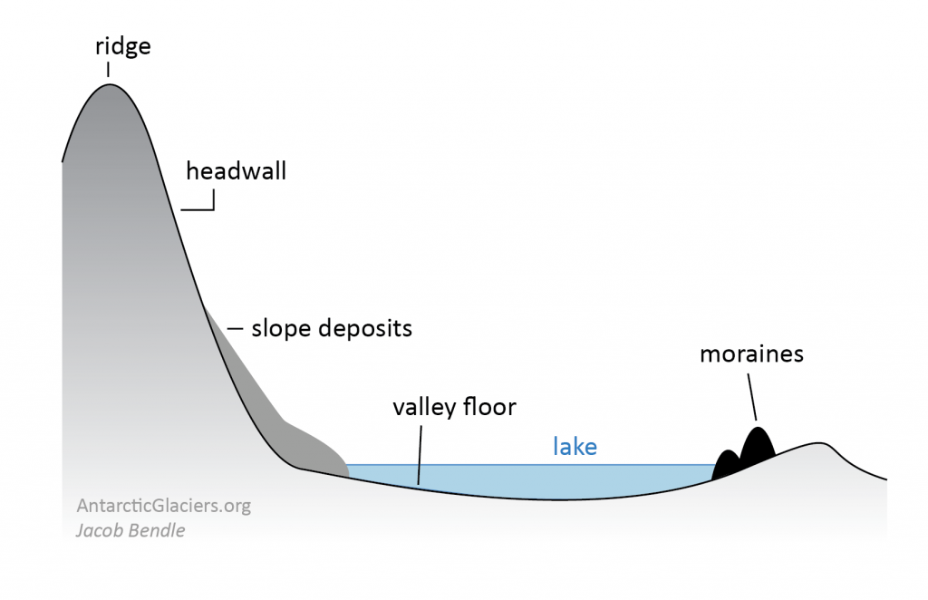
Horn- The sharp peak that remains after cirques have cut back into a mountain on three or more sides.
Aretes- When two cirques “eat” into a ridge from both sides, a jagged, knife- edge is formed.
Drift- Sediment carried by glaciers or the meltwater of glaciers.
Till- Unsorted rock material and unlayered rock material deposited directly by glaciers.
Erratic- A large rock deposited by a glacier that is different from the rock beneath it.
Outwash- Rock material deposited by the meltwater of a glacier.
Moraine- Mass of glacial tail left Behind after a glacier has melted.
End moraine- When the front end of a glacier remain stationary for period of years and the two piles up in a ridge along the front edge of the ice.
Terminal Moraine- Indicates the farthest advance of a glacier.
Recessional Moraine- Build up when the glacier recedes for awhile and then become stationary.
Lateral Moraine- Piles of till along the sides of a glacier.
Medial Moraine- When two glaciers come together the adjacent lateral moraines join and are carried by a single ridge of till.
Ground Moraine- A Fairly thin layer of till
Drumlin- Shaped like an inverted bowl of spoon with a long axis parallel to the direction of ice movement.
Stratified- Layered, well-sorted deposits.
Outwash Plain- A body of out wash that forms a broad plain beyond the moraine.
Kames- Short steep sided hills of outwash that originated as meltwater streams or lake deposits.
Kettle lakes- When an ice block forms and then melts it leaves a steep sided hole behind.
Esker- When the glacier melts the sinuous deposits from the river.
Loess- Fine grained wind-blown deposits of dust.
Plateaus- Large regions having horizontal rock structure at high elevations above sea level.
Often heavily dissected by streams so that they have steep valley slopes.
Drainage Basin- The area drained by a stream or system of streams.
Plains- An extensive region of low elevation where the land is level or gently rolling.
Dendritic pattern- Branching similar to that of the limbs or roots of trees.
Trellis pattern- Develops in valley-and- rugged terrain.
Rectangular pattern- Develops strongly jointed and faulted areas where the streams tend to follow the joint pattern.
Radial pattern- where streams radiate out from a central point on a large single peak such as on a volcano or rounded hill.
Dynamic equilibrium- A delicate balance of multiple environmental factors exists in all landscapes. A change in any one of the factors results in a modification of the landscape and the establishment of a new equilibrium.