Fieldwork (IB)
What is Fieldwork?
Fieldwork is a cornerstone of geographic learning. It's more than just studying textbooks or maps; it's about actively engaging with the world. Fieldwork allows students to step outside the traditional classroom walls and use this real-world environment as a laboratory.
There are three key aspects to fieldwork:
- Observation: Hone skills to identify and record geographical data. This data could include anything from landforms and vegetation to human settlements and infrastructure.
- Recording: The information gathered needs to be documented. This might involve taking notes, sketching maps and diagrams, or even capturing photographs and videos.
- Analysis and Interpretation: Once data is collected, it is analyzed and interpreted to understand the relationships between humans and the physical environment. This analysis could involve identifying patterns, trends, and cause-and-effect relationships.
By combining these elements, fieldwork allows one to learn about geography and experience it firsthand. Students can see how geographical theories studied in class play out in the real world.
Identifying a Fieldwork Topic
Choosing the right topic is crucial for a successful fieldwork project. Here's a breakdown of the key characteristics to consider:
- Short and Precise: Keep it clear and concise. The topic should clearly state what is being studied and where. It should be easy to understand at a glance.
- Researchable and Clear: Make sure there's enough information available to gather and analyze. A topic that's too broad or lacks sufficient data will be difficult to investigate effectively.
- Geographically Relevant: Remember, geography is all about the relationship between humans and the physical environment. The topic should focus on this connection.
- Unambiguous: Avoid topics that could be interpreted in multiple ways. A clear and well-defined topic will lead to a more focused and insightful study.
For example, instead of a broad topic like "Urbanization", a more focused and geographically relevant option could be "The impact of urban sprawl on green spaces in [City Name]."
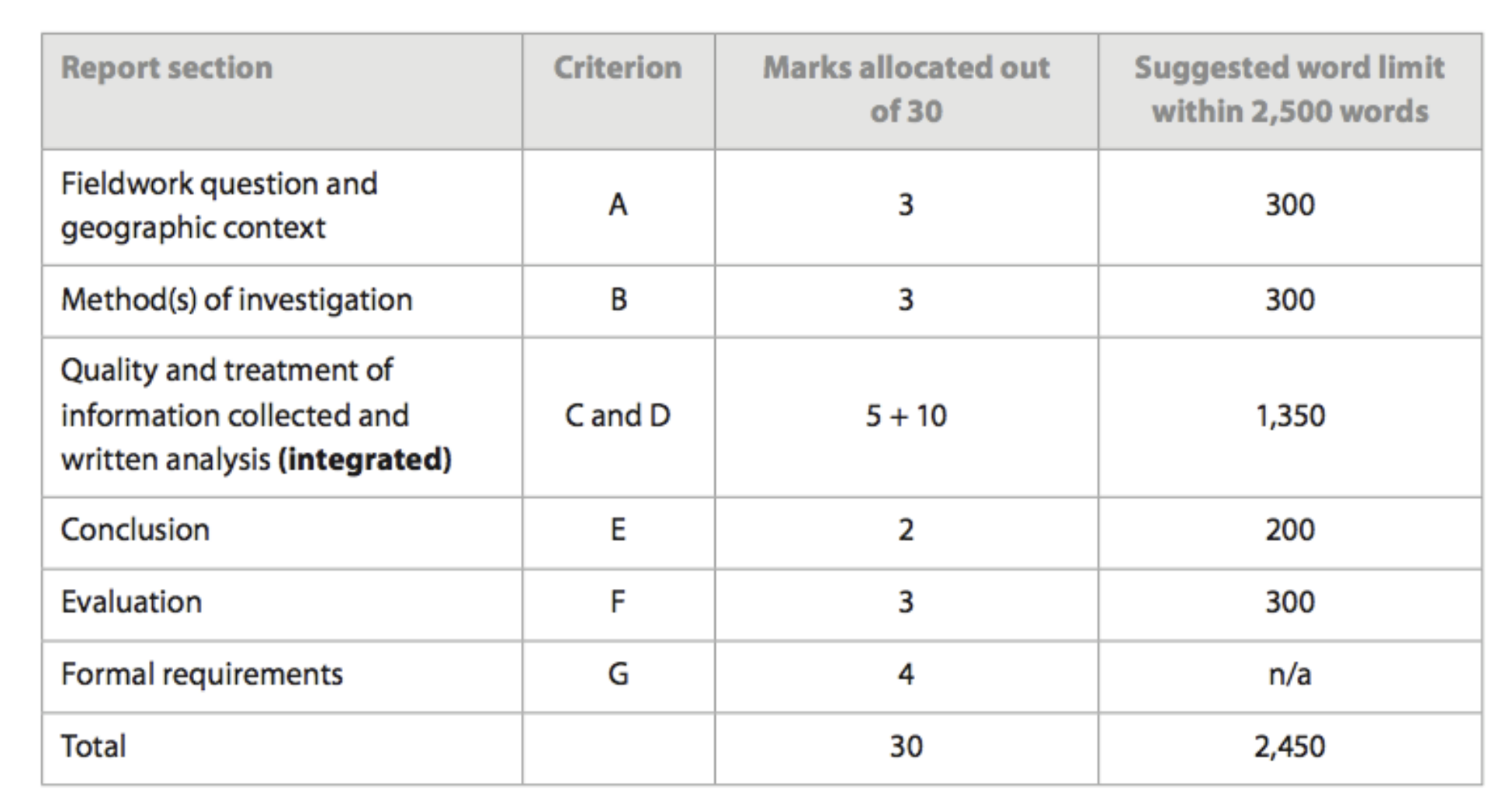
Formal Requirements
There are specific formatting and presentation guidelines for the fieldwork report. These ensure clarity, consistency, and proper referencing of work. Here are some key points to remember:
- The IA must not exceed 2500 words. Only footnotes of less than 15 words and text boxes with less than 10 words in them, the bibliography, and appendices are excluded from the word count.
- The IA is a piece of fieldwork based on primary data.
- The topic must relate to the syllabus and have a spatial element to it.
- It must be on a local scale, but not necessarily close to the local area of the school.
- Two or three hypotheses are recommended.
- Good map work with annotations and photographs that help to give locational context is recommended.
- It may be a good idea to use double spacing for your writing - check with a teacher.
- If using questionnaires, avoid questions that give Yes/No answers as this will limit the way data can be presented. Avoid long qualitative answers which will impinge on the word count.
- Creative presentation of data is rewarded, including hand-drawn graphs and charts.
- The focus of the write-up is the analysis, purely descriptive work will not produce high grades.
- Teacher support is vital. Seek advice from your teacher for completion of your work.
- Academic honesty is of the utmost importance - use consistent, clear referencing.
Formulating Objectives
Objectives are like mini-goals for the fieldwork project. They provide a clear direction for the research and help stay focused. Here are some key characteristics for effective objectives:
- Specific: Clearly state what the aim is to achieve with the fieldwork. Don't use vague terms like "understand" or "learn more about." Be specific about what aspects you want to understand or learn.
- Measurable: How will you know if you've achieved your objectives? Formulate them in a way that allows you to measure your progress and evaluate the success of your fieldwork.
- Focused and Narrow: Don't try to cover too much ground. Keep your objectives focused on a specific aspect of your chosen topic.
- Realistic and Achievable: Be realistic about what you can achieve within the timeframe and resources available for your fieldwork.
- Logical: Structure your objectives in a logical flow. Typically, they start with understanding the location and background, then move on to specific aspects, and finally consider future prospects.
- Related to the Topic: Don't simply repeat your topic in your objectives. They should elaborate on what you'll be investigating within the broader topic.
For example, an objective for the topic "The impact of urban sprawl on green spaces in [Your City Name]" could be: "To analyze the change in green space coverage within a specific district of [Your City Name] over the past decade due to urban development."
Data Collection Methods
There are various tools and techniques that can be used to gather data during fieldwork. Choosing the right method depends on the specific topic.
Here's a closer look at some common data collection methods used in geography fieldwork:
- Observation:
This is a fundamental skill in geography. It involves using your senses to actively record information about the environment. Here are some things to keep in mind:
Advantages: Useful in situations where interviewing isn't feasible, allows for studying natural processes as they unfold.
Limitations: Can be subjective (influenced by your own biases), and limited in scope for large areas or complex phenomena.
- Interviewing:
Talking to people directly can provide valuable insights and perspectives.
Advantages: Offers first-hand information from people who live or work in the area you're studying.
Limitations: Interviewer bias can influence responses, and language barriers may be a challenge.
- Recording:
This involves capturing information in a permanent form for later analysis.
Advantages: Creates a lasting record of your observations, and allows for organization and presentation of data.
Limitations: Weather conditions can damage notes or equipment, and lost materials can hinder analysis.
- Measurement:
This method is useful when you need to quantify specific aspects of your environment.
Advantages: Provides precise and objective data for analysis, and allows for comparison with existing data sets.
Limitations: Requires proper use of tools (which may be limited in availability), accuracy can be affected by tool malfunction or user error.
- Sampling:
Since it's often impractical to study an entire population, sampling allows you to collect data from a representative subset.
Advantages: Saves time and resources, and allows for detailed investigation of a smaller group.
Limitations: Incomplete data can lead to inaccurate conclusions if the sample isn't truly representative.
- Sketch Map Drawing:
Creating a sketch map is a visual way to document the spatial relationships between different features in your study area.
Advantages: Helps visualize the layout and connections between geographical elements, and provides a clear reference point for your observations.
Limitations: Whilst it can increase your final grade, accurate sketching requires skill and time.
Presenting Your Findings
Once you've collected your data, it's time to showcase your findings! Here are two key aspects to consider:
- Geographical Significance:
Explain how your fieldwork results contribute to the broader understanding of geography. This might involve:
- Relating your findings to existing geographical knowledge about the area.
- Highlighting the relationships between physical and human aspects of the environment.
- Problems Encountered:
Be honest about any challenges you faced during data collection. Explain how these problems may have affected your results and what you might do differently next time.
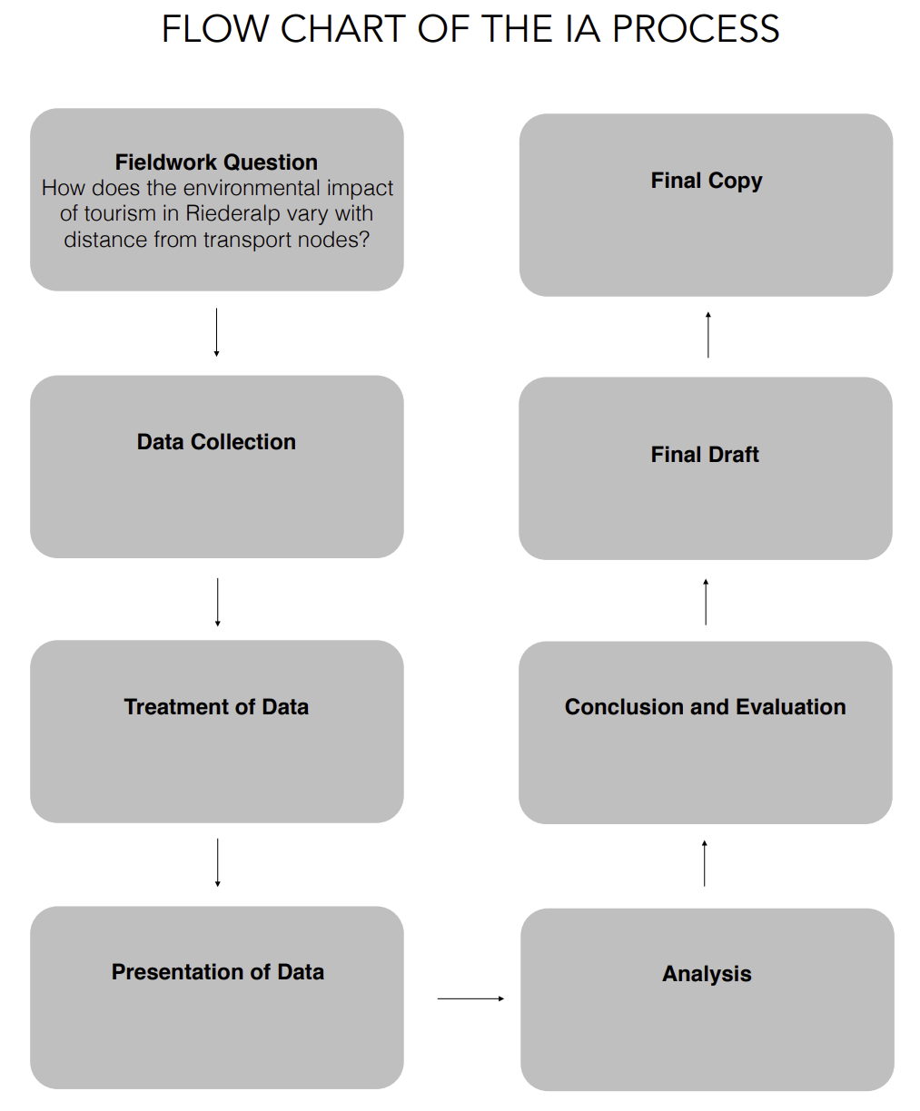
Follow-up Activities
Fieldwork doesn't end with data collection. Here are some essential follow-up steps:
- Data Analysis: This is where you make sense of your data. Organize, sort, and interpret the information you gathered. Look for patterns, trends, and connections between different data points.
- Refine Fieldwork Materials: Finalize any sketches, maps, or tables you created during data collection. Ensure they are clear, well-labeled, and ready for inclusion in your report.
- Compare Information: If you worked in a group, compare your findings and combine data for a more comprehensive picture. Discuss any discrepancies and work towards a cohesive analysis.
- Report Writing: Compile your findings into a final report that follows the required format. This typically includes an introduction, methodology, results, discussion, and conclusion sections.
Ethical Considerations:
- Respect for the Environment: Minimize your impact on the study area. Avoid damaging vegetation, disturbing wildlife, or littering.
- Respect for People: If interviewing people, obtain informed consent and ensure anonymity if promised. Be courteous and respectful of their time and privacy.
Safety:
- Plan Ahead: Conduct a risk assessment of your study area and identify any potential hazards.
- Work with a Partner: Never go on fieldwork alone, especially in unfamiliar areas.
- Inform Others: Let someone know where you're going, what you'll be doing, and when you expect to return.
- Be Prepared: Dress appropriately for the weather and terrain. Bring necessary supplies like water, sunscreen, insect repellent, and a first-aid kit.
Technology:
While traditional methods like pen and paper are still valuable, consider using technology to enhance your fieldwork:
- GPS Devices: Track your location and record waypoints for creating accurate maps.
- Digital Cameras: Capture high-quality photos and videos to document your observations.
- Data Collection Apps: Use specialized apps to record observations, conduct surveys, or collect measurements.