Khan Academy + FiveAble Unit 4 APES Notes - Earth's Systems and Resources
4.1 — Plate Tectonics
Convergent boundary — 2 tectonic plates moving TOWARDS each other — EX: Mariana Trench
Subduction takes place as the tectonic plate that is more dense moves under the plate that is less dense
Can be between 2 oceanic plates or a continental and oceanic plate but depending on the plates, different structures can form
2 Oceanic plates — island arcs, oceanic trenches, volcanoes
Oceanic plate and continental plate — mountains and volcanoes
Divergent boundary — 2 tectonic plates moving APART from each other — EX: Mid-Atlantic Ridge
Creates visible fault lines, rift valleys, seafloor spreading, volcanoes, and earthquakes
Seafloor spreading — divergent boundaries on ocean floor
As 2 tectonic plates move apart from each other, magma moves up and the water cools it to form more rocks
Transform boundaries — 2 tectonic plates slide past each other, causing earthquakes — EX: San Andreas Fault
Plates sliding past each other → friction and energy builds up → heat/energy releases quickly → earthquake

4.2 — Soil Formation and Erosion
Soil formation
Starts with parental material → weathering occurs and parental material is broken down into smaller and smaller particles + new particles introduced through deposition → small layer of soil formed allowing moss and other vegetation to grow → more soil horizons form and nutrients are added → soil continues to develop and organisms interact with it
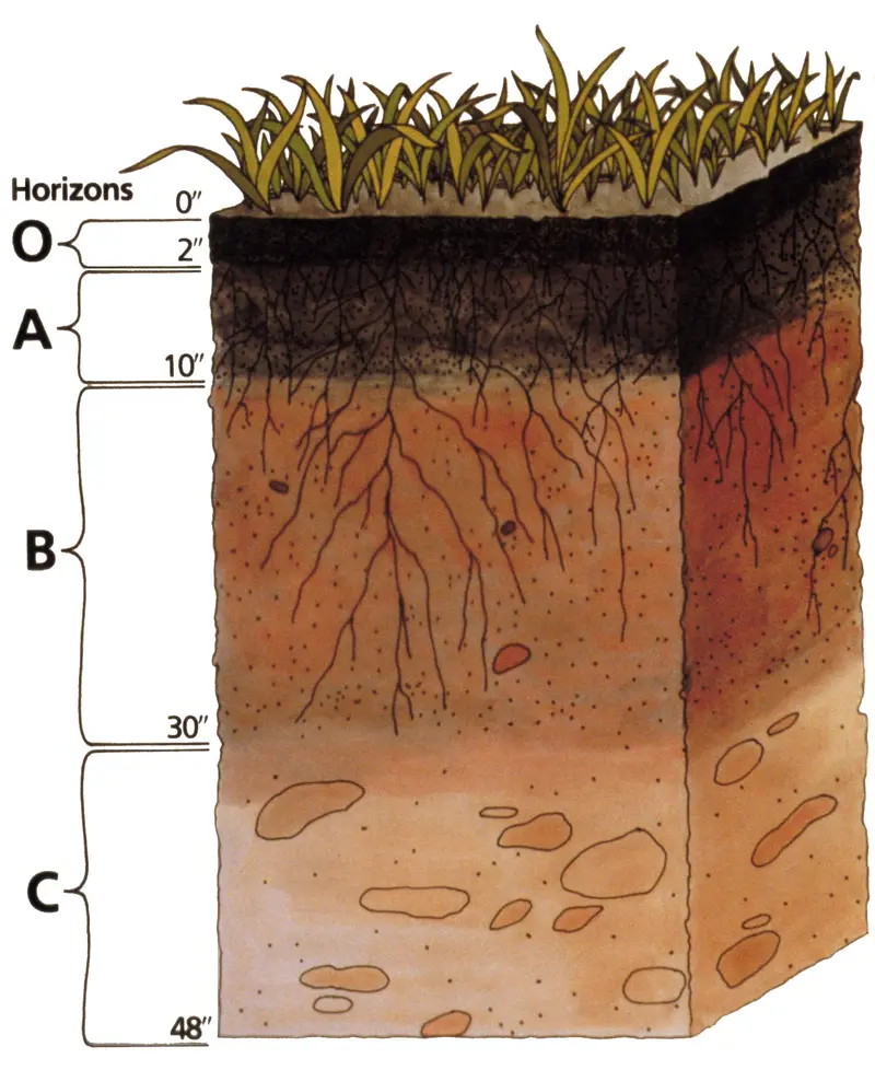
O Horizon (Humus)
Surface litter, like leaves and other decaying matter
A Horizon (Topsoil)
Mixture of organic materials with minerals
E Horizon (Eluviated)
Zone of Leaching, nutrients from upper horizons moves to lower horizons
B Horizon (Subsoil)
Zone of Accumulation where minerals such as iron and other nutrients accumulate
C Horizon (Parent Material)
The material that is broken down to create the soil
Bedrock
Solid rock that lies beneath the parent material and soil

4.3 — Soil Composition and Properties
Water-holding capacity/retention — amount of water that soil can absorb given the effects of gravity upon the soil and the amount of organic matter present
Soil with the most water retention = LOAM = equal amounts of small, medium, and large particles

Porosity — how porous the soil is — larger particles have larger pore sizes
Permeability — ability of nutrients and water to move down soil horizons — larger particles increase permeability of soil b/c there’s more space to move between particles
Fertility — nutrient levels and to what extent it is able to support vegetation

Chemical Properties
Soil pH:
Measures how acidic or basic the soil is
Affected by environment and pollution (e.g., acid rain)
pH impacts which plants can grow
Cation Exchange Capacity (CEC):
Soil particles attract cations (positively charged atoms)
Helps soil hold nutrients and maintain stable pH
High CEC = better nutrient and pH stability
Physical Properties
Aeration:
Ability of soil to let in air, water, and nutrients
Good aeration supports healthy plant growth
Soil Compaction:
How tightly soil particles are packed
High compaction = less pore space, lower aeration and permeability
Permeability:
How easily water and nutrients move through soil
Lower in compacted soils because there's less space for movement
Particle Size (related):
Affects how well soil drains and holds nutrients
Biological Properties
Determined by living things in the soil (e.g., bacteria, fungi, plants)
Varies by biome and climate
Organisms help build soil structure and nutrient content
4.4 — Earth’s Atmosphere
Major gases:
Water vapor — notably concentrated around the equator, where humidity and tropic-like conditions are more common
Greenhouse gases — including methane, carbon dioxide, nitric oxide, and ozone
Ozone — absorbs harmful UV radiation
Layers of the atmosphere:
Troposphere (1) — goes 10km up in altitude and is the shallowest layer of the atmosphere, and temperature decreases as altitude rises — all weather occurs here
Stratosphere (2) — 10km up to 50km in altitude and is mainly compromised of the earth’s ozone layer and the temperature increases with altitude
Mesosphere (3) — 50km to 80km in altitude, with temperature decreasing as you increase in altitude (cold temps all around)
Thermosphere/ionosphere (4) — traps protons, electrons, and other ions given off by the sun, with temperature increasing as altitude increases from UV radiation
Exosphere (5) — highest layer of the earth’s atmosphere and is the upper limit, merges with solar wind and the aurora borealis and aurora australis can be see here at its lowest points with molecules having low density in this atmosphere and with satellites orbiting it
4.5 — Global Wind Patterns
Solar radiation — earth’s axis → heat and solar radiation is unevenly distributed, making heat accumulate at the equator naturally and making the poles colder

Convection cells — found in the atmosphere and moves air from the equator to the poles
Hadley cells occur between 0° and 30° latitudes (directly north and directly south of the equator). At the equator, these cells start with warm, rising air. Then, as the air moves away from the equator, the air falls as cooler air.
Ferrel cells occur between 30° and 60° latitudes. Around the 30° latitude line, the cold, dry air of a Hadley cell falls, pushing warm air up.
Polar cells occur at latitudes greater than 60°. Polar cells start around the 60° latitude line where warm air from the Ferrel cells is pushed up. At higher latitudes, this air cools and falls as dry air on the poles.
Coriolis effect — deflection of moving objects, winds, and ocean currents due to the earth’s rotation, especially at long distances and high altitudes (where the rotation of the earth has the greatest influence)
Trade winds — the winds from the convection cells/high to low pressure
4.6 — Watersheds
Watershed — channel (stream/river) that concentrates runoff (water) to the main discharge point (a large body of water)
Typically, discharge point is the lowest point in the watershed
Headwaters — beginning of a watershed where runoff moves to lower elevation, forming streams and rivers
Streams and rivers diverge and create sub-watersheds but all the runoff discharges into ONE point
Characteristics of a watershed:
Size and area — reflects amount of runoff and what’s created by the runoff
Length and slope — runoff rate
Length of a watershed — how long it takes for runoff to reach discharge point
Type of soil — amount of runoff absorbed by soil
Vegetation — prevents erosion
4.7 — Solar Radiation and Earth’s Seasons
Main source of energy — solar radiation — affects different biomes during any season in specific ways like the length of a day
Latitude — solar radiation hits equator more
Season’s earth and tilt
Temperature differences/seasons caused by the orbit of the sun
Transition periods between summer and winter = equinoxes during every spring and fall/autumn
Solstices = highest and lowest points of the sun throughout the year
4.8 — Earth’s Geography and Climate
Factors that influence climate:
The sun
Earth’s orbit
Greenhouse gases
Volcanoes (Emit gases and ash into the atmosphere, influencing climate patterns and the distribution of sunlight)
Ocean currents (stores heat energy present on earth)
Land masses (blocks movement of air masses)
Rain shadow effect (occurs when moist air rises over a mountain range, leading to precipitation on the windward side and dry conditions on the leeward side, impacting local ecosystems and weather patterns).

4.9 — El Niño and La Niña
El Niño
Warms pacific ocean between South America and Papua New Guinea
Occurs when trade winds weaken, causing the west coast of S/A to experience warmer waters
Allows thermocline to move deeper
Causes higher precipitations in drier climates on the west coast but colder winters in southeastern US

La Niña
Cooling of pacific ocean between Papua New Guinea and South America — opposite of El Nino
Occurs when trade winds get stronger, pushing warm coastal further away from South America’s coastline
Deeper and colder waters rise — upwelling
Greater impacts:
Rapid climate changes causes species to suffer or require location due to their niche not allowing extremely warm/cold environments
Ocean heat capacity decreases and it is unable to absorb as much energy as needed, warming the planet