Hydrology Notes
INFILTRATION
Infiltration is the process of water penetrating into the soil.
Factors Affecting Infiltration Rate
Condition of the soil surface
Vegetative cover
Soil properties
Porosity
Hydraulic conductivity
Moisture content
Unsaturated and Saturated Flow
Unsaturated flow: Flow through a porous medium when some voids are occupied by air.
Saturated flow: Occurs when voids are filled with water.
Water Table
Interface between saturated and unsaturated flow.
Atmospheric pressure prevails at the water table.
Saturated flow occurs below the water table, and unsaturated flow occurs above it.
Control Volume Analysis
Consider a control volume with sides of lengthsdx, dy, and dz, having a volume of dxdydz.
The volume of water contained is \theta dxdydz. Where \theta is not defined in the document.
Darcy Flux
Darcy flux - Flowthrough the control volume
Defined as q = \frac{Q}{A}where Q is the volumetric flow rate and A is the soil area.
Darcy's Law
Relates Darcy flux (q) to the rate of head loss per unit length of medium.
For vertical flow, the head loss per unit length is the change in total head (\delta h) over a distance (\delta z), i.e., \frac{\delta h}{\delta z}.
Expressed as q = -K \frac{\delta h}{\delta z}, where K is hydraulic conductivity.
Unsaturated Flow Characteristics
Void spaces are partially filled with water.
Water is attracted to particle surfaces through electrostatic forces.
Suction head (\psi) - is the energy due to soil suction forces. (use average)
Total head (h) - is the sum of suction and gravity heads: h = \psi + z.
Darcy's law for unsaturated flow:
q = -K \frac{\partial(\psi + z)}{\partial z}.
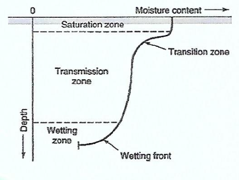
Green Ampt Method
Describes soil moisture distribution during downward movement.
Moisture Zones
Infiltration Rate
f: Rate at which water enters the soil surface (in/hr or cm/hr).
Potential infiltration rate: Rate when water is ponded; actual rate is less if no ponding.
Cumulative Infiltration
F: Accumulated depth of water infiltrated.
Expressed as F(t) = \int_{0}^{t} f(x) dx.
Infiltration rate: f\left(t\right)=\frac{dF\left(t\right)}{dt} .
Rainfall Hyetograph
Illustrates rainfall pattern as a function of time.
Increase in cumulative infiltration from time t to t + \Delta t is F(t + \Delta t) - F(t).
Rainfall excess: Rainfall that is neither retained nor infiltrated.
Green and Ampt Model
Simplified infiltration model.
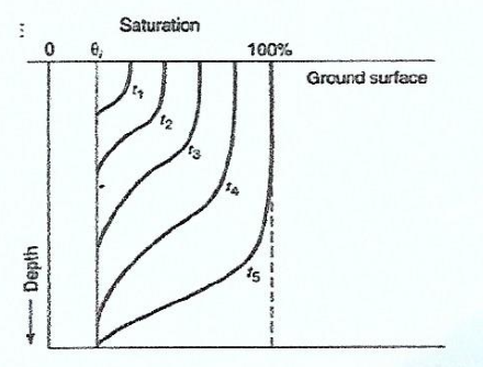
Wetting front: Sharp boundary dividing soil with moisture content \theta_i below and saturated soil with porosity n above.
Wetting front has penetrated to depth L in time t.
Water is ponded to a small depth h_0 on the surface.
Vertical Column of Soil
Consider a unit horizontal cross-sectional area.
Moisture content increases from \theta_i to n as the wetting front passes.
Increase in water stored: L(n - \thetai) = L\Delta\theta = F, where \Delta\theta = n - \thetai.
Cumulative infiltration: F(t) = L(n - \theta_i) = L\Delta\theta (Equation 7.4.17).
Darcy's Law Application
Expressed as q = -K \frac{\Delta h}{\Delta z} (Equation 7.4.18).
q = -f because q is positive upward and f is positive downward.
Boundary Conditions
Point 1 at the surface: h1 = h0.
Point 2 at the wetting front: h_2 = -\psi - L.
Darcy's law: f = K \frac{h_0 - (-\psi - L)}{L} (Equation 7.4.20a).
Assuming h_0 is negligible: f = K \frac{\psi + L}{L} (Equation 7.4.20b).
Wetting Front Depth
From Equation 7.4.17: L = \frac{F}{\Delta\theta}.
Substituting into Equation 7.4.20: f = K \frac{\psi \Delta\theta + F}{F} (Equation 7.4.21).
Differential Equation
Since f = \frac{dF}{dt}, Equation 7.4.21 becomes: \frac{dF}{dt} = K \frac{\psi \Delta\theta + F}{F}.
Solving for F
\frac{F}{\psi \Delta\theta + F} dF = K dt.
\int \frac{F + \psi \Delta\theta - \psi \Delta\theta}{\psi \Delta\theta + F} dF = \int K dt.
F(t) - \psi \Delta\theta { \ln[F(t) + \psi \Delta\theta] - \ln(\psi \Delta\theta) } = Kt (Equation 7.4.22a).
F(t) - \psi \Delta\theta \ln \left( 1 + \frac{F(t)}{\psi \Delta\theta} \right) = Kt (Equation 7.4.22b).
Green-Ampt Equation
Equation 7.4.22: Cumulative infiltration.
Infiltration rate: f = K \left[ \frac{\psi \Delta\theta}{F(t)} + 1 \right] (Equation 7.4.23).
If h0 is not negligible, substitute \psi + h0 for \psi in Equations 7.4.22 and 7.4.23.
Successive Substitution
Rearranging Equation 7.4.22: F(t) = Kt + \psi \Delta\theta \ln \left( 1 + \frac{F(t)}{\psi \Delta\theta} \right) (Equation 7.4.24).
Green-Ampt Parameters
n: Porosity
\theta_e: Effective porosity
\psi: Wetting front soil suction head (cm)
K: Hydraulic conductivity (cm/h)
\Delta\theta = (1 - S_e)n.
S_e: Effective saturation
\Delta\theta in terms of initial saturation Si: \Delta\theta = n - \thetai = (1 - S_i)n (Equation 7.4.26).
Sample Problem: Green-Ampt Method
Silty clay soil.
Time increments: 0.1 hr up to 6 hr.
Initial effective saturation: 20%.
Continuous ponding.
Ponding Time
Elapsed time between rainfall start and ponding.
Using Green-Ampt equation with constant rainfall intensity i.
Substituting F = it_p into Equation 7.4.23: i = K \left( \frac{\psi \Delta\theta}{F} + 1 \right).
Solving for tp: tp = \frac{K \psi \Delta\theta}{i(i - K)}.
Other Infiltration Methods
Ф-index Method
Constant abstraction rate.
Horton's Equation
Empirical relation: f = fc + (f0 - f_c)e^{-kt} (Equation 7.4.28).
Cumulative infiltration: Ft = fc t + \frac{(f0 - fc)}{k} (1 - e^{-kt}) (Equation 7.4.29).
Richard's Equation
Solved by Philip (1957, 1969).
Cumulative infiltration: F = St^{1/2} + Kt (Equation 7.4.30).
Infiltration rate: f(t) = \frac{1}{2}St^{-1/2} (Equation 7.4.31).
S: Sorptivity.
As t \to \infty, f(t) \to K.
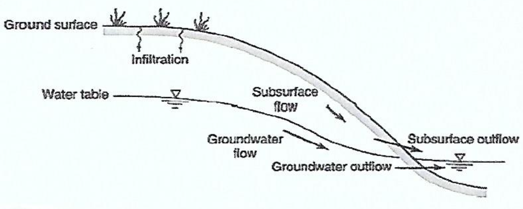
SUBSURFACE FLOW
Groundwater
Rocks below a certain depth are saturated.
Water flows towards lower elevation at equal pressure.
Water flows towards lower pressure at equal elevation.
Flow varies with material; larger holes mean faster flow.
Advantages of Groundwater
Less seasonal variation than surface water.
High biological purity due to slow movement.
Constant temperature.
Available virtually everywhere if deep enough.
Groundwater Properties
All water beneath the surface.
Occupies pores.
Porous media contains numerous small pores.
Pores contain fluids (water and air).
Pores act as fluid conduits.
Rock types and pore arrangement affect storage and flow.
Important Processes
Infiltration creates soil moisture.
Subsurface flow through soil.
Groundwater flow.
Soil Zones
Zone of aeration: Pores contain water & air.
Soil water zone: Water moves down (up) during infiltration (evaporation).
Vadose zone: Water held by capillary forces; near field capacity.
Capillary zone: Saturated at base, near field capacity at top; water pulled up from the water table.
Energy of Water in Soil
Cohesion: Water molecules attract each other.
Adhesion: Attraction between soil particles and water.
Meniscus: Curved air-water interface as water drains.
Determined by:
Pressure potential.
Gravity potential.
Osmotic potential: Water moves from low to high solute concentration.
Factors Affecting Water Movement
Soil texture (particle size).
Pore space.
Soil moisture content.
Slope of soil/rock layer.
Rates of Flow
Typical groundwater flow: 0.01 m/yr to 100 m/yr.
Permeability varies greatly; clean sandstone may have K = 0.1 m/s, while clay can have K = 1E-10 m/s.
Aquifers and Aquitards
Aquifer: Yields sufficient water.
Aquitard: Does not yield enough water.
Unconfined aquifer.
Confined aquifer.
Water Table
Intersects the land surface at lakes, ponds, and streams.
Streams can gain water from or lose water to the groundwater system.
Water table is closest to the surface at streams.
Perched water table.
Groundwater Use
Drawdown: Depression of piezometric surface due to pumping.
Cone of depression: Lowering of piezometric surface around a well.
Shape depends on hydraulic conductivity, storativity, and layer thickness.
Geologic Action by Groundwater
Weathering and cementation.
Karst: Erosion by groundwater, forms caves and sinkholes that collapses.
Types of Aquifers
Aquifer: Stores and transmits water.
Unconsolidated deposits: sand and gravel, sandstones etc.
Aquiclude: impermeable boundaries of aquifers; stores, doesn't transmit.
Clays and less shale
Aquitard: transmit don't store.
Shales and less clay
Leaky confining layers of aquifers
Confined aquifer: Bounded by impervious layers.
Unconfined aquifer:Bounded by a water table.
Groundwater Contamination
Plumes: Created when contaminants enter the aquifer.
Processes affecting plume movement:
Advection
Dispersion
Retardation
Chemical precipitation
Biotransformation
Plume Movement Processes
Advection: water carries substance
Dispersion: Spreading caused by advection
Retardation: Contaminants held to aquifer solids temporarily
Chemical Precipitation: heavy metals react with soils to precipitate in solid form.
Biotransformation: Chemicals change form or are destroyed
RUNOFF AND STREAMFLOW
Surface Runoff
Water that travels over the ground surface to a channel.
Peak Runoff Estimation by Rational Method
Q_p = CIA
C is runoff coefficient, i is rainfall intensity (m/s), A is watershed area (m²) and Q_p is peak runoff (cms)
Important for sizing storm water conveyance structures.
Limitations of Rational Method
Runoff coefficient isn't dependent Rainfall rate and antecedent moisture conditions
Rainfall is not uniform over the catchment area; Limit application to areas smaller than 80 has. (ASCE)
Higher coefficients should be used for less frequent storms as smaller percentage of rainfall abstraction
Streamflow
Measure of water volume transported by a stream.
Stream Parameters
A stream begins at its headwaters, often in the mountains, fed by an underground spring or the runoff from rain and snow melt
Measured by determining the cubic feet per second or gallons per hour.
Factors Influencing Flow Velocity
Depth of stream channel
Width of stream channel
Roughness of stream bottom
Slope or incline of surrounding terrain
Factors Influencing Stream Volume
Weather or climate
Seasonal changes
Merging tributaries
Human impact
Measurement
Discharge: volume of water that flows past a point during a specific time, Usually reported as the number of cubic feet of water passing a point each second (cfs)
Stillings wells are used to measure a streamflow
Watershed
Area of draining to a stream
Streamflow generated by water entering surface channels
Affected by Physical, vegetative, and climatic features and Geologic considerations
Annual Hydrographs and Storm Hydrographs
Baseflow Separation Techniques
Straight line method
Fixed base method
Variable slope method
DIRECT RUNOFF AND EXCESS RAINFALL
Excess (effective) rainfall
Rainfall that is not retained or infiltrated
Becomes direct runoff
Excess rainfall hyetograph(excess rainfall vs time)
Abstraction (losses)
Phi Index
Difference between total and excess rainfall hyetographs
Constant rate of abstraction yielding excess rainfall hyetograph with depth equal to depth of direct runoff
a = \sum{m=1}^{M} (Rm - A_t)
Water Runoff Coefficients
Ratio of the peak rate of direct runoff to the average intensity of rainfall in a storm
Ratio of runoff to rainfall over a given time period
\frac{\sum Rd}{\sum Rm}