PMT notes notes - Coasts
Classifying coasts
The coast is an open system as it receives inputs from outside the system, transfers within the system and gives outputs away from the coast and into other systems
The other systems that interact with the coastal system can be terrestrial, atmospheric or oceanic
However, sediment cells are closed systems, as sediment does not get transferred from one cell to another
Sediment cells and Feedback Loops
There are 11 sediment cells in England and Wales. They have:
Sources - where the sediment originates from (cliffs or eroding sand dunes)
Through flows - Movement of sediment along the shore through longshore drift
Sinks - Locations where depositional landforms are created (ie. spits, salt marshes, dunes)
Under normal conditions, the coastal system operates in dynamic equilibrium - where inputs and outputs are in a constant state of change but remain in balance
The coastal system has mechanisms which enhance changes, taking it away from dynamic equilibrium, but it also has mechanisms that balance changes, taking the system back towards equilibrium
Negative feedback loops lessen change which has occurred within the system
For example, a storm could erode a large amount of a beach, taking it out of dynamic equilibrium, as there is larger input of sediment into the system than output. This works thus:
When the destructive waves lose their energy, excess sediment is deposited as an offshore bar
The bar dissipates the wave energy and protects the beach from further erosion
Over time the bar gets eroded instead of the beach
Once the bar has gone normal conditions ensue and the system returns to dynamic equilibrium
Positive feedback loops exacerbate change in a system, making it more unstable and taking it away from dynamic equilibrium:
People walking over sand dunes destroys vegetation that is growing there and causes erosion
As the roots from the vegetation have been holding the dunes together, the dunes now erode quicker.
Eventually the sand dunes will be completely eroded, leaving more of the beach open to erosion taking the beach further away from dynamic equilibrium
The Littoral Zone
The littoral zone is the area of the coast where land is subject to wave action. It is constantly changing and varies due to:
Short-term factors such as tides and storm surges
Long-term factors such as changes in sea level and climate change
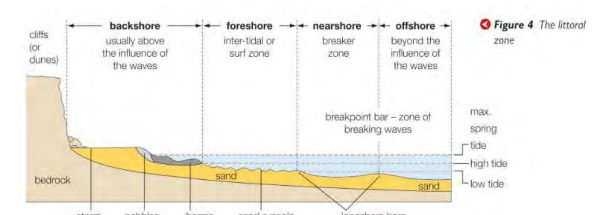
There are several subzones within the littoral zone:
Backshore - area above high tide level only affected by very high tides
Foreshore - area where most wave processes occur
Offshore - the open sea
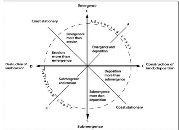
Valentine’s Classification
A Valentine’s Classification describes the range of coastlines that can occur
An advancing coastline is a coastline that is growing out into the foreshore - land emerging or deposition is usually the prominent process here
Alternatively, a coastline may be retreating due to the land submerging or erosion being the prominent process
Post-glacial adjustment / post-glacial rebound - When there is isostatic sea level change as a result of the land rebounding from melting glaciers
Emergent or submergent coastlines may be due to post-glacial adjustment
One axis on the classification shows emergence to submergence, and the other shows erosion to deposition. One diagonal axis shows a coast in equilibrium, and the other diagonal axis goes from fully advancing to fully retreating
Erosional processes
Erosion is a process which involves the removal of sediment from a coastline by different types of erosion, not by one type acting by itself
Processes of erosion:
Corrasion - Sand and pebbles are picked up by the sea from an offshore sediment sink are hurled against the cliffs at high tide, causing the cliffs to be eroded
Abrasion - The process where sediment is moved along the shoreline, causing it to be worn down over time
Attrition - Wave action causes rocks and pebbles to hit against each other, wearing each other down to become smaller and rounder - is an erosional process on the coastline, but has little impact on erosion of the coastline itself
Hydraulic action - As a wave crashes onto a rock or cliff face, air is forced into cracks, joints and faults within the rock. The high pressure causes the cracks to force apart and widen when the wave retreats and the air expands. Over time this causes the rock to fracture.
Cavitation - Bubbles within the water may implode under high pressure creating tiny jets that erode the rock
Corrosion (Solution) - The mildly acidic seawater can cause alkaline rock such as limestone to be eroded in a process similar to carbonation weathering
Wave Quarrying - Where breaking waves that hit the cliff face exert a pressure up to 30 tonnes per square metre. These waves can enlarge joints and remove large chunks of rock in one vibration
Erosion rates are highest when:
Waves are high and have a long fetch
Waves approach the coast perpendicular to the cliff (so all the wave energy is in the direction of the cliff)
It is high tide - waves travel higher up the cliff so a larger area of the cliff face can be eroded
Heavy rainfall has occurred - water percolates (filters gradually through porous rock) through permeable rock, weakening the cliff
It is winter - destructive waves are the largest and most destructive during winter
Vulnerability to Erosion
Clastic rocks - Made of sediment particles cemented together
Crystalline rocks - Made of interlocking mineral crystals
The resistance of a rock will determine its vulnerability to erosion, and is influenced by various factors:
Whether rocks are clastic or crystalline - sedimentary rocks are clastic and are therefore more vulnerable to erosion, whereas igneous and metamorphic rocks are crystalline, and are therefore less vulnerable to erosion
The amount of cracks, fractures and fissures - the more weaknesses there are in a rock, the more open it is to erosional processes, especially hydraulic action
The lithology of the rock - the type of rock directly affects its vulnerability to erosion, with igneous having the most resistant lithology
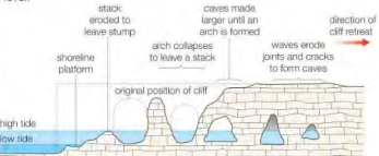
Erosional Landforms
The sequence from a fault to a stump occurs on a headland.
Erosion widens faults in the base of the headland, widening over time to create a cave
The cave will widen due to both marine erosion and sub-aerial processes
This will then erode to the other side of the headland, creating an arch
The arch continues to widen until it is unable to support itself, falling under its own weight through mass movement, leaving a stack as one side of the arch becomes detached from the mainland
With marine erosion attacking the base of the stack, eventually the stack will collapse into a stump
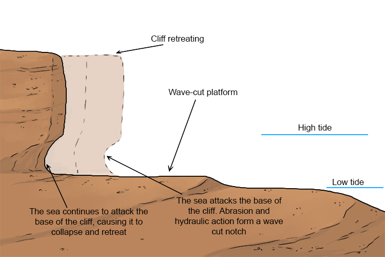
Wave cut platforms:
Marine erosion attacks the base of a cliff, creating a notch of eroded material between the high and low tide mark
As the notch becomes deeper, the cliff face is undercut and becomes unstable, falling under its own weight
This leaves behind a platform of the unaffected cliff base beneath the wave-cut notch, as the cliff retreats
Through the process of repeated wave-cut notches and platforms, new cliff faces are created as the land retreats
Blowhole:
A blowhole is a combination of two features: a pot hole on top of a cliff created by chemical weathering, and a cave formed through marine erosion
As the cave erodes deeper into the cliff face and the pothole deepens, they may meet
In this case, a channel is created where the incoming waves can travel through and up the cliff face, causing water to splash out the top of the blowhole when energetic waves hit the cliff face
Transport and deposition
Longshore drift (littoral drift):
Sediment is predominantly transported along the coast through the process of longshore drift
It transports sediment along the beach and sometimes even between sediment cells
Process:
Waves hit the beach at an angle determined by the direction of the prevailing wind
The waves push sediment in this direction and up the beach as the swash
Due to gravity, the wave then carries sediment back down the beach in the backwash
This moves sediment along the beach over time
It is one of the reasons that you move across while swimming in the sea
Traction - Large, heavy sediment rolls along the sea bed, being pushed by currents
Saltation - Smaller sediment bounces along the sea bed, being pushed by currents
Suspension - Small sediment is carried within the water column
Solution - Dissolved material is carried within the water
Effectiveness of transportation:
The impact of transportation depends on the severity of the angle that waves travel onto the land
Swash-aligned - Wave crests approach parallel to the coast so there is limited longshore drift. Sediment does not travel far or fast
Drift-aligned - Waves approach at a significant angle, so longshore drift causes the sediment to travel far up the beach
Likelihood of deposition:
Deposition occurs when a wave loses energy, meaning that the sediment becomes too heavy to carry
Deposition is a gradual and continuous process - a wave will not just spontaneously drop all of its sediment
Gravity-settling - Wave energy becomes low so heavy rocks and boulders are first deposited, and then the next heaviest sediment and so on
Flocculation - Rock particles that float (such as clay) will in theory never be deposited, however they will clump and stick together due to chemical attraction and then sink due to the resulting weight
Depositional Landforms
Spits:
A spit is a long, narrow strip of land which is formed due to deposition
Longshore drift occurs along the coast line but as the waves lose energy (every time the wave breaks it loses energy), they deposit their sediment
Over time this creates a spit, which forms when the coastline curves around or reaches an estuary, but longshore drift and deposition carries on in the original direction of the coast
Periodically, the prevailing wind will change direction, causing a hook shape to appear
Over time, the sheltered area behind a spit can turn into a salt marsh
The length of a spit is influenced by surrounding currents or rivers
For example, if a spit spans part of an estuary, then the river current will prevent it from going all the way across the river, and therefore a recurved spit end is formed
Bars:
A spit is formed
Over time, this spit crosses across a bay and links up two sections of coast
The water within the bay is then called a lagoon, as it is sheltered from the open sea
Tombolo:
A tombolo is a bar or beach that connects the mainland to an offshore island
It is formed due to wave refraction off the coastal island, leading to deposition of sediments
Sometimes they are covered at high tide, which can mean people get trapped sometimes
Cuspate Foreland:
Only occurs with triangular shaped headlands
Longshore drift along each side of the headland will create beaches
These beaches meet and form a cuspate foreland, which sticks out perpendicular to the direction of the coastline

Offshore bars:
A region offshore where sand is deposited, as waves don’t have enough energy to carry the sediment to the shore
Formed if the wave breaks early, depositing its sediment as an offshore bar
They can also be formed from the strong backwash in storms, as sediment is carried off the beach and offshore
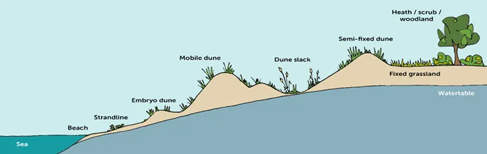
Sand dunes
Tidal range - The distance between high tide and low tide
Berm - Raised section in which shingle or sand is deposited, it is above the high tide mark
Sand dunes occur when prevailing winds blow sediment to the back of the beach, and therefore the formation of dunes requires large quantities of sand and a large tidal range. This allows the sand to dry out, so that it is light enough to be picked up and carried by the wind to the back of the beach. Frequent, strong winds are also necessary
The dunes develop thus:
Embryo dunes - Upper beach area (above the berm)where sand starts to accumulate around a small obstacle, such as driftwood, a wooden peg or a ridge of shingle
Yellow dunes - As more sand accumulates and the dune grows, vegetation may develop on the upper and back dune surfaces, which stabilise the dune - yellow dunes are the tallest of all the dune types
Grey dunes - Sand develops into soil with lots of moisture and nutrients as vegetation dies and fertilises the soil, enabling more varied plant growth
Dune slack - The water table rises closer to the surface, so plants that need lots of moisture can be present here
Heath and woodland - Sandy soils develop as there is a greater nutrients content, allowing for less saline plants to grow. Trees can also grow, with the coastal woodland also acting as a windbreak
Stability of depositional landforms
Depositional landforms are mostly formed of unconsolidated sediment (sand with very little vegetation and with small sediments)
Therefore, during major storms, large amounts of sediment can be eroded or transported elsewhere, which can remove a landform, sometimes entirely, from one region of the sediment cell
Depositional landforms depend on a continuous supply of sediment to stay in dynamic equilibrium, which may see some landforms changed as their dynamic equilibrium shifts