Earth Surface Processes
Intro to Earth Surfaces
Topography - surface of the earth
Earth’s acne
Water
36,000,000,000,000,000 gallons
Reservoir = temporary storage places for water (earth’s pimple patch??)
Residence time
Oceans = 97.20%
Ice = 2.15%
Groundwater = 0.62%
All others = 0.03%
Lakes
Rivers
Ponds
Atmosphere
Water fluxes
Flux - the forces that move water from one reservoir to another
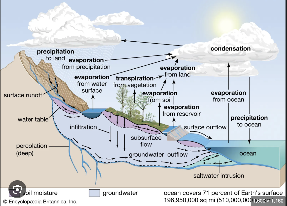
The Water Cycle
Hydrologists = hydrology
Hydrology is the study of water
The Hydrologic cycle - how water moves
Desert
The clouds are scaring the hoes (water)
Can be found on the other side of the mountain
Precipitation = rain, sleet, snow (it’s falling water so like the sky’s hormones are going crazy)
I’ll update the picture and finish the notes once he’s done lecturing so don’t sweat the details (and don’t focus on my bad spelling)
P = R + I + E + T
Precipitation
Runoff
Infiltration
Evaporation
Transpiration
Runoff
Rivers, Streams, Flash floods
flux → Reservoirs
water flows downhill
bc of gravity
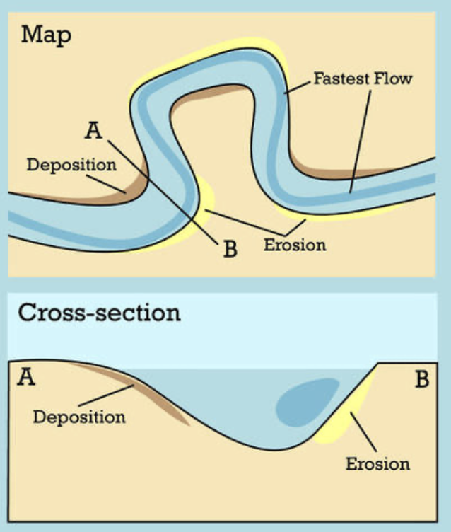
Top part of the picture is upland streams and the main river is the lowland river
When it rains
Water hits land → runs off or can seep into the ground → runoff goes to drainage base (land indents guiding water to river) → river
Upland streams v. Lowland rivers
Upland streams
…_…_…_ = Channel (important stream) on a map
Straight Channel - can cut through rock 🤨 and you can’t walk across it safely or it looks like 😄 -v- 🤕
can be a V-shaped valley
V-shaped valley formed from when water is so fast it slowly cuts down the rock forming a sharp valley
Intermittent Channel - a mostly dry channel bc the water is too fast ☹
water can go fast (100mph)
it’s sonic basically

Upland Streams continued
Stream Load - things carried by water in the stream
the water is rock shaming but carries it regardless
Mostly Sand & gravel
The big stuff is called the “bed load”
MAX load = competence
Suspended load floats. Defies Gravity igs

Lowland rivers
Perennial Channel
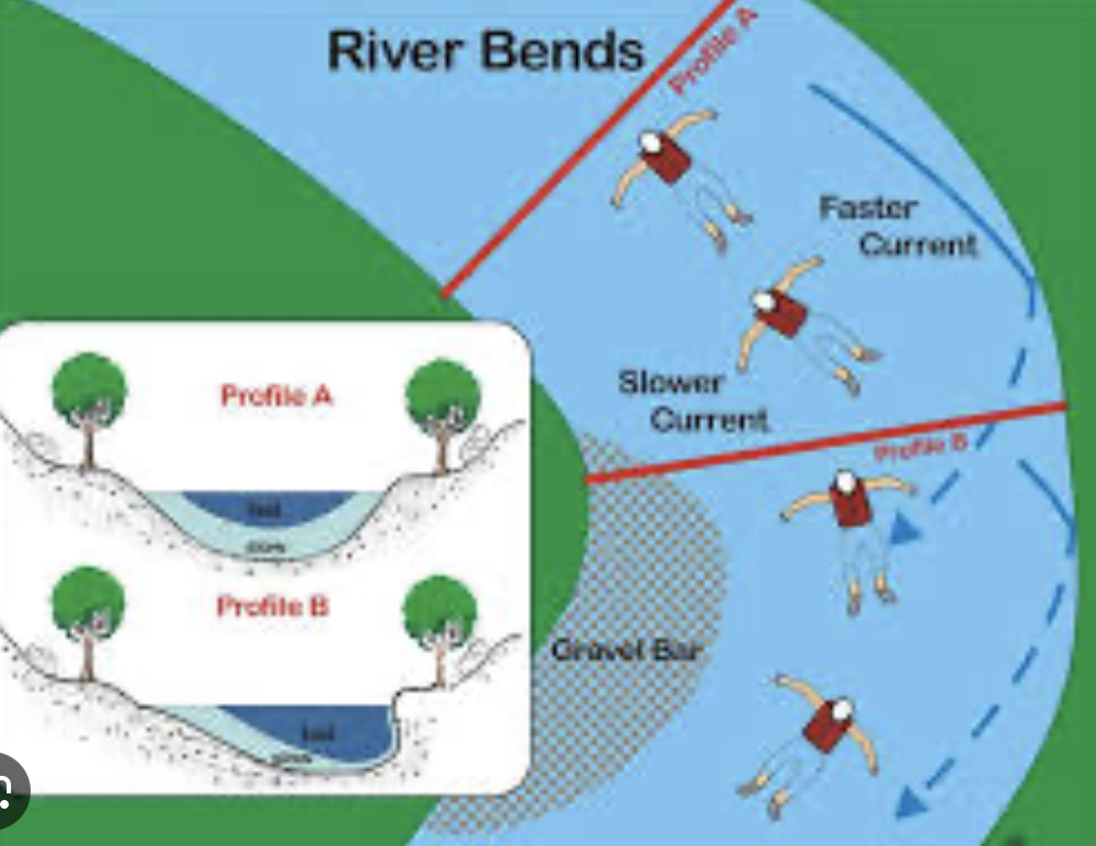
Lots of meanders ( curves/turns/bends in the river)
Wide Channels
Like 2 miles
If you try to walk across it looks like 😃 -~u- 🤕
Each side of the river (the land right next to the river) is a flood plain (wider the river→ wider the floodplain)
Water flow is slow
Both
capacity = maximum
competence = maximum size of load (is the stream strong enough to push it)
Work together to slowly destroy mountains
Upload streams (Very fast water flow)
Intermittent channels
Straight channels
small channels
deep V-shaped valleys (down cutting)
Low capacity
High competence
Runoff - Upland streams + Lowland Rivers
Bank
Floodplain
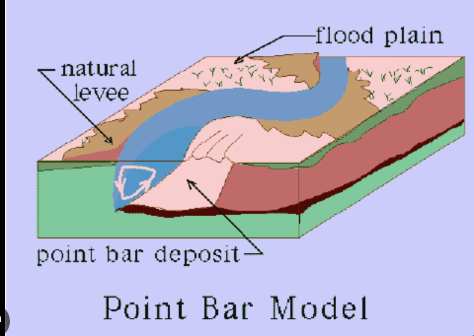
don’t build on cut back side of a river
making U-shaped valleys
side-cutting
happens when the river is done side cutting
Well they happen simultaneously
BUT SLOW
AI version of water notes…
Water is an essential component of the Earth's systems and plays a significant role in various processes:
Topography: The shape and features of the Earth's surface, which influence water movement and storage.
Water Sources: Earth holds approximately 36,000,000,000,000,000 gallons of water. The distribution is as follows:
Oceans: 97.20% of Earth's water is stored in oceans.
Ice: 2.15% is in ice and glaciers.
Groundwater: 0.62% is found underground.
Other Sources: 0.03% includes lakes, rivers, ponds, and the atmosphere.
Reservoirs: These are temporary storage places for water, impacting the residence time of water in different compartments.
Water Fluxes: The movement of water between different reservoirs is driven by various forces, termed fluxes, which determine how water transitions from one state to another (e.g., from liquid to vapor, from surface to groundwater).
Understanding these processes helps in grasping the dynamics of the Earth's hydrological cycle and the significance of water in sustaining various ecosystems and human activities.
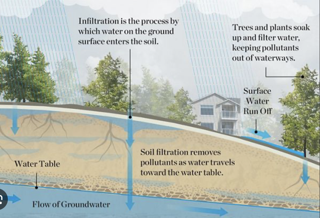
Infiltration
Flux
infiltration → groundwater
underground water that is MOVING
it creates features
flux → reservoir
Need good
Porosity
porosity = % open space in loose sediment/rock
Granite cracks easy, but not porous
sand is very porous
clay has tinyyyyy particles and NOT POROUS (low porosity)
Permeability
permeability = interconnected nature between pores or openings
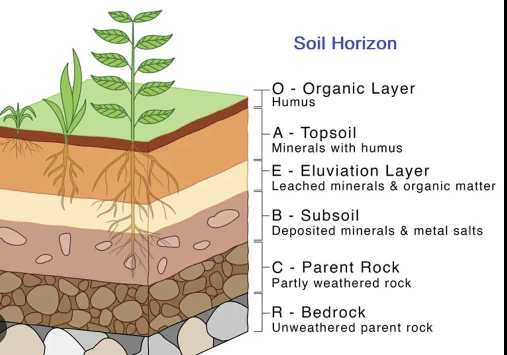
Soil profile - weathered rock + organic material
Regolith - weathered rock
Bedrock
Unsaturated zone - pores have air and water
Saturated zone - pores 100% full of water
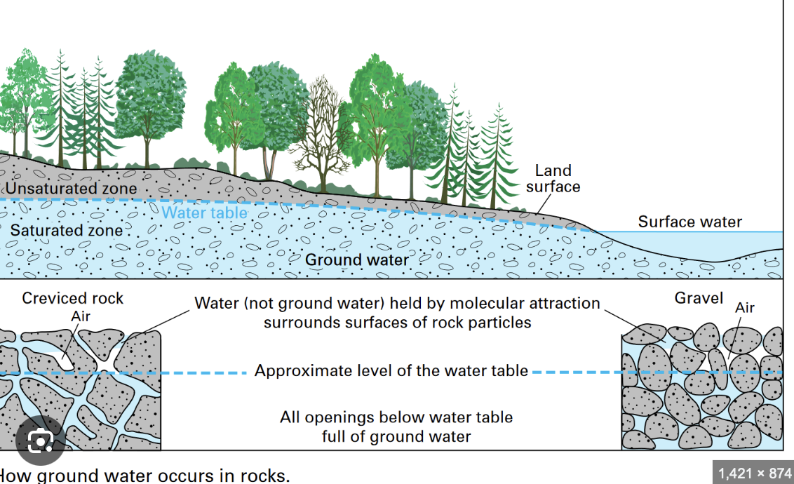
Aquitards - doesn’t let the water flow easily
Slows it down/stops it
R***** water
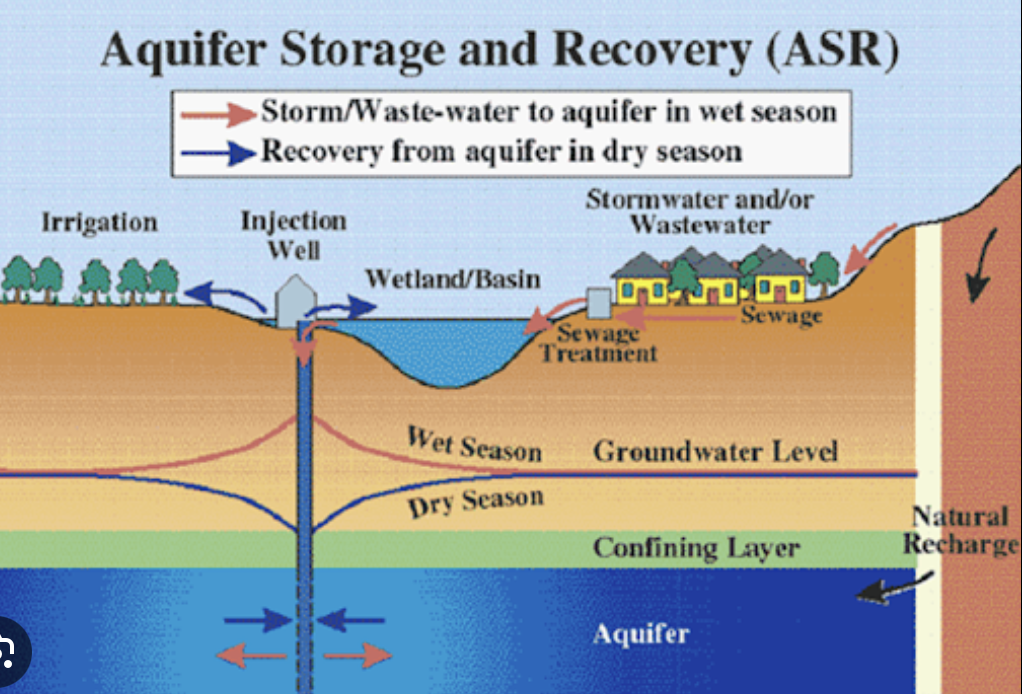
Aquifer - lets water flow easily
They’re surrounded (layered) with each other
lots of pressure I fear
water is thicc bro
she’s heavy
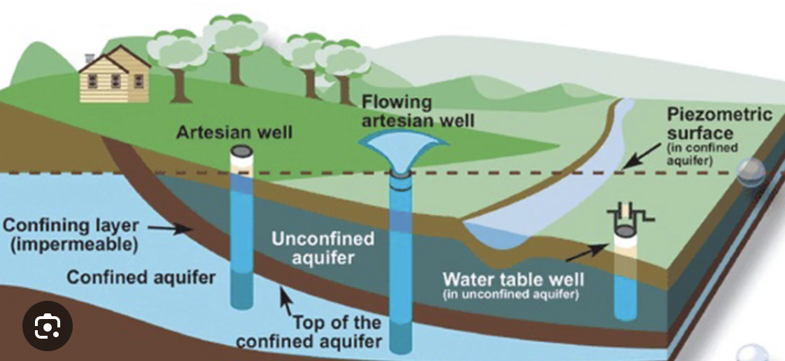
Unconfined Aquifer
Water Table
Confined Aquifer
Artesian wells
water form river (rio grande)
Wells filter what water plants CANNOT
boil water notices bc of low pressure
*artificial pressure tho igs
LBV building
Impermeable pure clay
over time a little water table built up above the main water table
So TAMIU has Perch water tables
baby water table perched on the main one
the library too ❤
easy to find perch water tables
mineral gipson (idk how to spell it)
looks like quartz
it’s malleable
groundwater is loaded with dissolve gipson (i still don’t now how to spell it)
Infiltration - Groundwater
Karst Topography
Karst
Dissolved
Bedrock = limestone
limestone is made of the crunchy parts of dead critters (light snack for the rock)
Limestone doesn’t like acidity
H2O +CO2 → H2CO3
second thingy is carbonic acid
rainwater dissolves away limestone
Limestone is basically a type of rock that forms from tiny bits of dead sea animals and plants that sink to the ocean floor. Over a really long time, these bits get squished together to make a solid rock. It's kind of like a giant sandy beach, but instead of just sand, it’s full of little pieces of creatures. If you mess with limestone using something acidic, like vinegar, it fizzes and bubbles because the acid is reacting with the rock. So, it’s like the rock is having a tiny fizzy party when it meets acid!
Dripstone, also known as stalactites and stalagmites, are formations that look like icicles inside caves. They happen when water drips from the ceiling of a cave and leaves behind tiny bits of minerals as it drips. Over a long time, these minerals build up and create these cool rock shapes. Think of it as nature's way of making rock candy, but instead of candy, it creates pointy rocks hanging from the ceiling and from the floor!
caves. They/re cool.
weird water wearing away rock
Sinkhole
when dumbasses build on top of caves and it actually falls down
Sinkhole lake
water hole below water table full of water
and silly geese slowly seep into it if they build heavy stuff on top of it
sinkhole but like with water
ground water makes caves
Deserts & Dry Climates
Desert - region on the earth that over a long period of time receives less than 10 inches of rainfall per year
some science books say 25cm (but we think in freedom units)
3 different types of deserts identified based on where they are
Tropics region (equator area) not a desert this was click bait (idk what I’m supposed to right)
low lat desert (subtropical)
mid lat desert (rain shadow)
High lat desert (polar)
Sub tropical deserts
It’s hot so we have a lot of deserts
lots of attention from the sun
Polar deserts
no rain <3
It’s cold (af)
Rain Shadow Deserts

Mid lat
Think that one magic schoolbus episode - the desert one
FLASH FLOODS
this is a big one
makes crazy features in deserts
Wind does the bare minimum
Eolian Processes (wind processes)
Big word for silly goose wind activity
Eolis was the god of wind the silly goose
air and movement
treating wind like water?
wind has load (little rocks and stuffs it carries ❤ )
loess → clay and fine salt
This is dust
removes loess from environment
ends up dumped in the rain or a wet area
Pedestal rock - that cartoon ahh looking rock is real
Fluval Processes
rivers
streams
flash floods
death valley california
plate tectonics
comit broke up that
basin and range
laredo is in the laredo basin
which is why it’s so damn hot
knocks off rounded peices of mountains into
ALLUVIAN FANS
idk what it is but i’ll google it
Bagada - wtv this is
little dots mean intermittent streams (streams that only exist when it rains
make funky looking lakes
they’re actually large mud puddles
playa lakes
stores knock the mountains down → fills up valleys → becomes death valley (yippie)
Inselberg
Rocky hill
bye bye desert, hello beach front house 😍
Shoreline Processes
Waves do most of the shaping
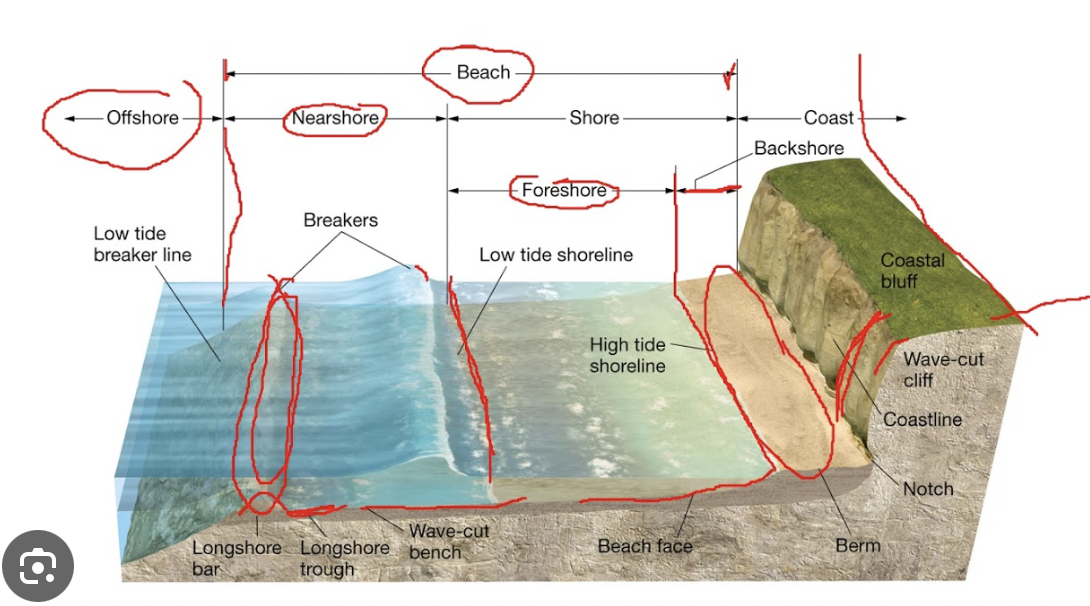
water is heavy
Shoreline isn’t straight
~
Wave bending = wave refraction
bend
like water bending lol
Foamy area = surf
Shoreline Processes involve the shaping and changing of coastal landscapes primarily through the action of waves. Waves are responsible for most of the erosion and deposition activities along shorelines. Two key concepts in shoreline processes are:
Wave Bending (Wave Refraction): This occurs when waves approach the shore at an angle and are bent, leading to the concentration of wave energy on certain parts of the shoreline, affecting erosion and deposition patterns.
Fills in the bays
cuts off the headlands
California coast is a young shoreline
she a curvy shoreline
Eastern side of the United States is an old shoreline
More straight
Impact of Waves: Waves constantly shape coastlines by eroding materials and transporting sediments, leading to features like beaches, cliffs, and coastal dunes.
Human activities significantly impact shorelines in various ways, including:
Coastal Development: Constructing buildings, roads, and other infrastructure alters natural landscapes and can lead to increased erosion or habitat destruction.
Dredging and Sand Mining: These practices can remove sediment from the seabed, affecting the natural sediment flow and leading to altered coastal dynamics.
Sea Walls and Jetties: While intended to protect shorelines from erosion, these structures can disrupt natural wave patterns and sediment transport, often leading to increased erosion down the coast.
Pollution: Runoff from urban areas and agricultural lands can pollute coastlines, harming marine life and disrupting ecosystems.
Climate Change: Rising sea levels and increased storm frequency due to climate change threaten coastal areas, leading to more severe erosion and habitat loss.
Overall, human impact on shorelines can disrupt local ecosystems, increase vulnerability to natural disasters, and affect the long-term stability of coastal landscapes.
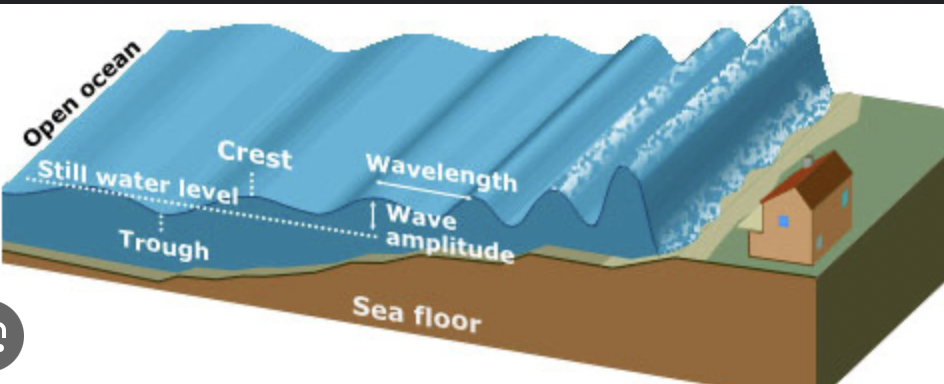
The wavelength of a wave can be calculated using the formula:
Wavelength (λ) = Wave Speed (v) / Frequency (f)
Where:
Wavelength (λ) is measured in meters (m).
Wave Speed (v) is the speed of the wave in meters per second (m/s).
Frequency (f) is the number of waves that pass a point in one second, measured in hertz (Hz).
For example, if a wave travels at a speed of 10 m/s and has a frequency of 2 Hz, the wavelength would be:
λ = 10 m/s ÷ 2 Hz = 5 meters.
In coastal areas, water moves faster in the offshore zone, where the waves are still approaching the shore, compared to the slower-moving water in the nearshore zone and on the beach where waves are breaking. This difference in water speed contributes to varying levels of erosion and deposition along the shore. Fast-moving water often leads to more significant erosion of the coastline, creating features such as cliffs and sea stacks, while slower water can result in the deposition of sediments, forming beaches and sandbars.
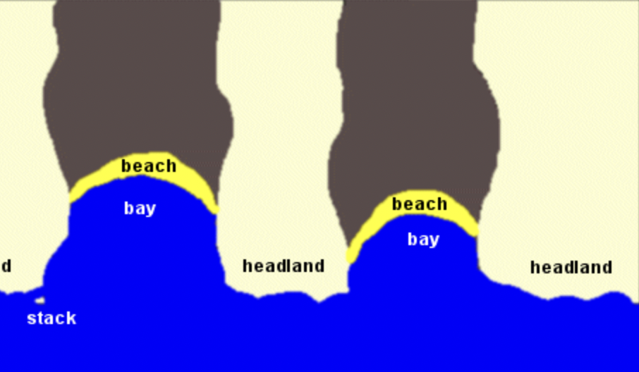
Headlands: These are prominent points of land that extend into a body of water, formed through the erosion of softer rock along the coastline while the harder rock remains intact. Headlands often experience strong wave action, leading to significant erosion along their sides. The process can result in vertical cliffs and steep shorelines.
Bays: Bays are recessed areas in the coastline that are partially enclosed by land. They occur where softer rock has eroded away, allowing water to fill these depressions. Bays can provide calm waters, making them good locations for harbors and recreational activities. They often have gently sloping shores and can serve as important habitats for varied marine life.
Beach Formation: Beaches are formed through the accumulation of sediments brought in by wave action. As waves approach the shore, they transport sand, pebbles, and other materials with them. When waves break upon the shore, they lose energy and deposit these sediments, gradually forming the beach.
Beach drifts
Beach Formation: Beaches are formed through the accumulation of sediments brought in by wave action. As waves approach the shore, they transport sand, pebbles, and other materials with them. When waves break upon the shore, they lose energy and deposit these sediments, gradually forming the beach.
Beach drifts occur as the waves push sand and sediment along the shore in a process influenced by the angle at which waves hit the beach. This sideways movement of sediment can lead to the continuation of beach expansion or erosion and affects the shape and characteristics of the shoreline.
Called a spit
the point in the beach drift
How Water Breaks: Water breaks when waves reach shallow waters, causing them to slow down and increase in height. When the wave crest becomes too steep to support its weight, it collapses and spills over, creating a 'breaking wave.' This process enhances the movement of sediments along the beach as the backwash from the wave pulls materials back toward the ocean.
In oceanography, a groin is a structure built out into the water from a beach to prevent erosion and manage sediment deposition. Groins are typically constructed of rock, concrete, or other materials and extend perpendicularly from the shore. They work by trapping sand that is moved along the coastline by waves and currents, helping to maintain the width of the beach on one side while potentially causing erosion on the other side due to changes in water flow. Groins are a common coastal engineering solution used in beach management.
A lagoon is a shallow body of water separated from a larger sea or ocean by a barrier such as a coral reef, sandbar, or barrier island. Lagoons can be classified into two main types: coastal lagoons, which are close to the coast and often created by sediment deposition, and atoll lagoons, which are found within atolls and surrounded by coral reefs. Lagoons provide important habitats for various marine species and serve as breeding grounds for fish and other wildlife. They also play a significant role in filtering pollutants and protecting coastlines from wave action.
Longshore Currents:
Longshore currents are coastal currents that move parallel to the shore, resulting from waves hitting the shore at an angle.
These currents are significant for sediment transport along the coastline, moving sand and other materials.
As waves approach the shore, they become refracted, intensifying the current and facilitating the erosion and deposition processes that shape beaches.
Sea Stacks:
Sea stacks are geological formations that occur when a headland is eroded over time, leaving isolated columns of rock in the sea.
They are formed by the relentless erosion of waves at the base of a cliff, leading to the collapse of the cliff face, while the harder rock remains standing.
Sea stacks are often found near coastal areas with significant wave action and can become important landmarks in the landscape.
Tides are caused primarily by the gravitational forces exerted by the moon and the sun on Earth's oceans. The moon, being closer to the Earth, has a stronger influence on tides compared to the sun, even though the sun is much larger. Here's how it works:
Gravitational Pull: The moon's gravitational force pulls water toward it, causing a bulge or high tide on the side of the Earth facing the moon.
Centrifugal Force: As the Earth and moon orbit a common center of mass (the barycenter), the centrifugal force created by this movement results in a second bulge on the opposite side of the Earth, causing another high tide.
Low Tides: Between these high tide bulges, the water level is lower, resulting in low tides.
Sun's Influence: The sun also exerts gravitational forces on Earth's waters; when the sun, moon, and Earth align (during full moons and new moons), the tidal effects are amplified, leading to higher high tides and lower low tides, known as spring tides. When the sun and moon are at right angles to each other relative to Earth, the tides are less pronounced, creating neap tides.
Overall, the interaction between gravitational forces, the Earth's rotation, and the positions of the sun and moon create the regular rise and fall of sea levels known as tides.
MARS STOLE ROCKS FROM THE ASTEROID BELT
they’re two timing whores ☹
it’s not a true moon
gravity wants to stretch everything
Rock and metal don’t stretch
Water does tho
The moon generates bulges with it’s magnetic pull
generating daily tides
bulge = high tide
low side of bulge = low tide
The fact we have a moon and the earth rotates gives us tides
The end.
monthly tides
Earth’s period
bi-monthly
super high tides and super low tides
Hormonal waves tbh
Real name - Spring tides
Neap tides
More energy in the waves in the spring tide
so the processes move faster/ are stronger for spring tides
meanwhile they’re slowed down for neap tides
hurricane fast - spring tide season
hurricane slow - neap tide season
Lunar phases
Moon plays hard to get
moon is lit by the sun
through reflected sunlight
moon isn’t a lightbulb
Lunar phases significantly influence monthly tides due to the gravitational forces exerted by the moon and its position relative to the Earth and the sun.
Here’s a detailed breakdown of how lunar phases affect tide predictions:
Phases of the Moon and Tidal Influence
New Moon and Full Moon (Spring Tides):
During the new moon and full moon phases, the sun, moon, and Earth are aligned.
This alignment amplifies the gravitational pull on the Earth's water, resulting in higher high tides and lower low tides, known as spring tides.
These tides are characterized by their significant vertical changes in water levels due to the combined gravitational forces.
First Quarter and Last Quarter (Neap Tides):
During the first quarter and last quarter phases, the moon is at a right angle to the sun concerning the Earth.
This position leads to lower tidal ranges because the sun's gravitational force partially offsets that of the moon.
These lower high tides and higher low tides are referred to as neap tides, which occur approximately one week after spring tides.
Monthly Tidal Patterns
28-Day Cycle: The lunar cycle lasts about 29.5 days from one new moon to the next, influencing the cycle of spring and neap tides within this period.
Tidal Predictions: The predictable patterns of the moon's phases allow scientists and researchers to forecast tides effectively.
Harmonic Tidal Models: These models use historical tidal data combined with the lunar phase information to improve tidal predictions.
Conclusion
Understanding how lunar phases govern the gravitational dynamics contributing to tidal patterns allows researchers and coastal planners to better predict and prepare for tidal variations, which is vital for navigation, flood management, and ecological health.