
2024 Test Prep Remote Pilot Notes
Introduction
To take an FAA Airman Knowledge Test, all applicants must establish an FAA Tracking Number by creating a profile in the Integrated Airman Certification and Rating Application system at iacra.faa.gov.
Then visit faa.psiexams.com to register for your exam and take FAA-created practice tests to become familiar with the computer testing platform.
Answer every question because some may later be marked “no right answer,” and you’ll be given full credit if you choose one.
Chapter 1: Regulations
The rules about small unmanned aircraft systems are outlined in the National Airspace System (NAS) for purposes OTHER than hobby and recreation
these rules are specified in Title 14 of the Code of Federal Regulations (14 CFR) Part 107, “Small Unmanned Aircraft Systems”. This part addresses sUAS classification, certification, and operational limitations and applies to the operation of certain civil small unmanned aircraft within the NAS.
A small, unmanned aircraft includes the criteria:
weighs less than 55 pounds (25 kg), including everything that is onboard/attached to aircraft (not 55 pounds and below! LESS THAN 55 pounds, like 49.999!)
are operated without the possibility of direct human intervention from within or on the aircraft
Different terms for small, unmanned aircraft: UA, UAS, and sUAS
an sUAS includes the unmanned aircraft itself and its associated elements that are required for safe operation, such as communication links and components that control the aircraft
Control station (CS): an interface used by the remote pilot or the person manipulating the controls to control the flight path of the sUA
Corrective lenses: spectacles or contact lenses
Model aircraft: a UA that is:
capable of sustained flight in the atmosphere
flown within the visual line-of-sight (VLOS) of the person operating the aircraft; and
flown for hobby or recreational purposes
Person manipulating the controls: a person other than the remote PIC who is controlling the flight of an sUAS under the supervision of the remote PIC
Public aircraft: means any of the following
an aircraft used only for the U.S. government
and aircraft owned by the government and operated by any person for purposes related to crew training, equipment development, or demonstration
an aircraft owned by the government of a state, the D.C., or a territory or possession of the U.S., etc
an aircraft exclusively leased for at least 90 continuous days by the government of a state, the D.C., etc
an aircraft owned or operated by the armed forces or chartered to provide transportation or other commercial air service to the armed forces
Remote pilot-in-command (remote PIC or remote pilot): a person who holds a remote pilot certificate with an sUAS rating and has the final authority and responsibility for the operation and safety of an sUAS operation conducted under Part 107
Small unmanned aircraft (sUA): a UA weighing less than 55 pounds and can be flown without the possibility of direct human intervention from within or on the aircraft
Small unmanned aircraft system (sUAS): a sUAand its associated elements (including communication links and the components that control the sUA) that are required for the safe and efficient operation of the SUA in the NAS
Unmanned aircraft (UA): an aircraft operated without the possibility of direct human intervention from within or on the aircraft
Visual observer (VO): a person acting as a flightcrew member who assists the sUA remote PIC and the person manipulating the controls to see and avoid other air traffic or objects aloft or on the ground
Remote Pilot Certification
Pilot certifications listed the certification level which defines the privileges and limitations of that certificate holder, such as remote pilot, private pilot, flight instructor, etc.
it will include the category of aircraft as well in which the pilot is qualified to fly it
A SUA is a “rating”
A person acting as a remote PIC of an sUAS in the NAS under Part 107 MUST obtain a Remote Pilot Certificate with an sUAS rating issued by the FAA before operation
Requirements for a Part 107 Remote Pilot Certificate:
be at least 16
be able to read, speak, write, understand English
be in a physical and mental condition that would not interfere with the safe operation of sUAS
fulfill training and testing requirements
renew every 24 months
The application for the test must be submitted to a Flight Standards Office (FSDI), a designated pilot examiner (DPE), an airman certification representative for a pilot school, a certified flight instructor, or another person authorized by an FAA Administrator to process it
You must pass a background check
Remote Pilot Privileges
The remote pilot must:
be designated before each flight (but can change during the flight)
ensure that the operation poses no undue hazard to people, aircraft, or poverty in the event or loss of control of the aircraft for any reason
operate the small unmanned aircraft to ensure compliance with all applicable provisions and regulations
Being able to safely operate the sUAS relies on the physical and mental capabilities of the remote PIC, person manipulating the controls, VO, and any other direct participant in sUAS operation
Another certified pilot may take over the controls if he or she is certified , both capable of maintaining VLOS of the sUAS, and without loss of the operation
Supporting Crew Roles
A person without a Remote Pilot Certificate may operate a sUAS as along as he or she is directly supervised by a remote PIC and the PIC can take over if something goes wrong (see Part 107)
The remote PIC can take over the controls by:
using a “buddy box” system that uses two control stations (CS): one for the person manipulating the flight controls, and one for the remote PIC that allows the remote PIC to override the other CS and immediately take controls of the sUAS
or the remote PIC standing close enough to the person manipulating the controls to take control
employ the use of an automation system whereby the remote PIC could immediately engage that system to put the sUA in a pre-programmed “safe” mode
An autonomous operation is when the autopilot on board the sUA performs certain functions without direct pilot input
the remote PIC must still be able to change routing or altitude
The role of VOs is to alert the rest of the crew about potential hazards during sUAS operations
they are optional
they must be positioned in a location where they are able to see the sUAS continuously and sufficiently to maintain VLOS, and possess a means to effectively communicate the sUAS position and the position of other aircraft to the remote PIC and person manipulating the controls
Falsification, Reproduction, or Alteration
The FAA may take appropriate action against an sUAS owner, operator, remote PIC, or anyone else who fraudulently or knowingly provides false records or reports, or otherwise reproduces or alters any record, reports, or other info for fraudulent purposes
Accident Reporting
The remote PIC must report any sUAS accident to the FAA within 10 days if:
serious injury to any person or any loss of consciousness
damage to any property, other than the small unmanned aircraft, if the cost is greater than $500 to repair/replace property
The report must be submitted to FAA Regional Operations Center (ROC) or FSDO electronically (faa.gov/uas) or by phone
The report should have:
sUAS remote PIC’s name and contact info
sUAS remote PIC’s airman certificate number
sUAS registration number issued to the aircraft, if required (FAA registration number)
location of the accident
date of the accident
time of the accident
person(s) injured and extent of injury
property damaged and extent of damage
description of what happened
A serious injury qualifies as Level 3 or higher on the Abbreviated Injury Scale (AIS) of the Association for the Advancement of Automotive Medicine, used by medical personnel
Certain sUAS accidents must also be reported to the NTSB
FAA Inspections
You must carry, in case of an FAA inspection, the following documentation:
Pilot certificate
Aircraft registration
Any necessary waiver or exemption
other documentation related to the operation
sUAS Registration
Owners must register the sUAS if it greater than 0.55 pounds, less than 55 pounds, and operated under the provisions of Part 107
The aircraft must be registered by someone over the age of 13
A Certificate of Aircraft registration expires 3 years after the date of issue unless it is renewed
An sUAS operation requires a Foreign Aircraft Permit if it involves a civil aircraft that is:
registered in a foreign country
owned, controlled or operated by someone who is not a U.S. citizen or permanent resident
Before operation, mark the sUAS to identify that it is registered with the FAA. The marking must be:
a unique identifier number
legible and durable
visible
Remote Identification (Remote ID)
Remote ID is the ability of a drone in flight to provide ID and location info via radio frequency (ex: Bluetooth) that can be received by other parties. This includes:
a unique identifiers for the drone
the drone’s latitude, longitude, geometric altitude, and velocity
an indication of the latitude, longitude, and geometric altitude of control station (standard) or takeoff location (broadcast module)
A time mark
Emergency status (standard remote ID drone only)
No person may operate a sUA within the airspace of the U.S. unless it meets the requirements of 14 CFR unless authorized by FAA
Standard remote ID broadcasts ID and location info about the drone and its control station
A remote ID broadcast module is an alternative remote ID device that broadcasts ID and location info about the drone and its takeoff location in accordance with the remote ID rule’s requirements
The Certificate of Aircraft Registration of the unmanned aircraft used in the operation must include the serial number of the remote ID broadcast module, or the serial number of the unmanned aircraft must be provided to the FAA in a notice of ID prior to the operation
Operations without remote ID may also be conducted in an FAA-recognized ID area (FRIA)
Preflight Action and Inspection
The remote PIC must complete a preflight familiarization, inspection, and other actions, such as crew-member briefings, prior to beginning flight operations. Like so:
assess the operating environment including local weather conditions, local airspace, flight restrictions, the location of persons and property on the surface, and other ground hazards
inform any supporting crewmembers about the operation and their roles (such as operating conditions, emergency procedures, contingency procedures, roles and responsibilities of each person involved in the operation, as well as potential hazards)
Inspect the sUAS to see that it is in a condition for safe operation (control links between control station and the small unmanned aircraft are working properly, enough power, objects carrier are secure,
Maintain documents required in the event of an FAA inspection
Carriage of Hazardous Material
A sUA cannot carry any hazardous material
Hazardous material is anything the Secretary of Transportation has determined is capable of posing an unreasonable risk to health, safety, and property when transported
Operation at Night
For operations under civil twilight and night, the sUAS must be equipped with anti-collision lights that are capable of being visible for at least 3 SM
The PIC may momentarily reduce light if it impacts night vision
Civil twilight is the period of time before sunrise and after sunset when the sun is not more than six degrees below the horizon
14 CFR Part 1 defines night as the time between the end of evening civil twilight and beginning of morning civil twilight
Civil twilight lasts about 30 minutes after sunset or before sunrise
Visual Line of Sight (VLOS)
The sUAS must remain with VLOS of flight crewmembers
without the aid of any device other than corrective lenses (glasses/contacts)
The sUA must be operated closely enough to the CS to ensure visibility requirements are met during small unmanned aircraft operations
For operational necessity, the remote PIC may maneuver the sUA so he or she loses sight of it briefly (ex: looking at the edge of a rooftop)
Operating Limitations
The sUAS must be operated in accordance with the following:
cannot be flown faster than a ground speed of 87 knots (100 mph)
Cannot be flown higher than 400 ft above ground (unless flown within a 400-ft radius of a structure and not flown higher than 400 ft above the structure’s immediate uppermost limit)
Crewmembers must operate within the following limitations:
minimum visibility, as observed from the location of the control station, must be no less than 3 SM
minimum distance from clouds must be no less than 500 ft below a cloud and 2,000 ft horizontally from a cloud
Right-of-Way Rules
No person may operate a sUA that interferes with operations and traffic patterns at any airport, heliport, or seaplane base
The remote PIC has to yield right-of-way to all other aircraft, manned or unmanned, and avoid hazards
referred to as see and avoid
To satisfy this, the remote PIC must:
know the location of flight path of his or her sUA at all times
be aware of other aircraft, persons, property nearby
be able to maneuver the sUA to
avoid a collision
prevent other aircraft from having to take evasive action
Avoid operating anywhere where the presence of his or her sUA may interfere with operations at the airport, such as approach corridors, taxiways, runways, and helipads
Yield right-of-way to all other aircraft, including aircraft operating on the surface of the airport
First-person view camera cannot satisfy this requirement, but VOs can
Operation Over Human Beings
No person may operate an sUAS over a human being unless:
That human being is directly participating in the operation of the sUAS
They are under a covered structure/stationary vehicle that gives protection from a falling sUAS
the operation meets the requirements of at least one of the operational categories specified in Sub-part D of Part 107 outlined below:
To conduct Category 1 Operations the sUAS must meet the requirements of 107.110
To conduct Category 2 Operations the sUAS must meet the requirements of 107.115
To conduct Category 3 Operations, the sUAS must meet the requirements of 107.125
To conduct Category 4 Operations the sUAS must meet the requirements of 107.140
There are 4 categories of operations over people.
Category 1: The aircraft weighs no more than 0.55 pounds AND has no exposed rotating parts (that would cause lacerations). The Tello aircraft meets these criteria, with the propellor guards installed. Note that if you intended sustained flight over open air assemblies of people, the aircraft must also have remote ID. The Tello as configured out of the box fails on that account (it has no remote ID).
Category 2: "... must not be capable of causing an injury to a human being that is more severe than an injury caused by a transfer of 11 ft-lbs of kinetic energy from a rigid object." This is to be certified by the manufacturer or modifier of the aircraft. As in category one, there must be no exposed rotating parts that can cause laceration. Remote ID is also required.
Category 3: This increases the allowable transfer of energy to 25 ft-lbs; prohibits flying over open-air assemblies of people; and requires the operation to be over a restricted access area in which all people present are aware of the UAS operation OR the pilot doesn't maintain sustained flight over people unless they are protected by a structure or inside a stationary vehicle. Remote ID is not mentioned explicitly for this category of operations but remote ID is required for operations except in very specific areas (FAA-Recognzed Identification Areas (FRIAs)), so you should assume it is required. There are a few AgEagle drones certified for Category 3.
Category 4: If you don't fit into one of the above 3 categories, you must get an airworthiness certification - just like for crewed aircraft - for your drone from the FAA. Remote ID is required.
No person may operate an sUAS over a human inside a moving vehicle unless it means 1 of 4 operational categories for operations over people
To conduct Cat 1: the sUAS must remain within or over a closed- or restricted-access site, all human beings made aware that an sUAS may fly over them, and the sUAS must not maintain sustained flight over the moving vehicle
To conduct Cat 4: the sUAS must have an airworthiness certificate and be operated in accordance with the operating limitations specified
For all operations conducted under Cat 2 and 3 the sUAS must meet a means of compliance (MOC) and be listed on a current Declaration of Compliance (DOC)
the MOC must consist of a test, analysis, and inspection of procedures for the sUAS detailing how the sUAS meets the requirements for Cat 2 and Cat 3
it should include conditions, environments, and methods, as applicable
this info needs to be submitted along with a compliance explanation of how application of the MOC fulfills the requirements
Operation from Moving Vehicles or Aircraft
Part 107 allows sUAS operation from a moving land or water vehicle over a sparsely populated or unpopulated area, but no controlling it from an aircraft
sUA that are transporting another person’s property for compensation or hire may not be operated from any moving vehicle
Operations from moving vehicles are subject to the same restrictions that apply:
PIC must maintain VLOS
the VO and PIC must maintain communication
no reckless operation (don’t drive while controlling it)
Privacy and Other Considerations
No person may operate a drone in a careless manner that may endanger another person or property
Part 107 also prohibits allowing an object to be dropped from a drone in a way that causes undue hazard to persons or property. Such as:
operations that interfere with manned aircraft operations
operating an sUAS over persons not directly participating in the operation
loading the sUAS beyond its capabilities where it loses control
You may operate an sUAS to transport another person’s property for compensation if you comply with also:
the total weight of the sUA is below 55 pounds
the sUAS operation must be within bounds of a state
no items may be dropped from the aircraft that damage person or property
you may not operate it from a moving vehicle or vessel
carriage of hazardous material is not permitted
stay in VLOS of the pilot
Alcohol and Drugs
Part 107 does not allow operation of an sUAS if the remote PIC or VO is unable to carry out duties
ex: drugs, alcohol, over-the-counter medication
A refusal to submit to a test to indicate the percentage of blood alcohol is grounds for:
denial of an application for a Remote Pilot Certificate with a sUAS Rating for up to 1 year
suspension or revocation of a Remote Pilot Certificate with an sUAS rating
Change of Address
A remote PIC must update the FAA Airman’s Certification Branch within 30 days if they move
Or their privileges are taken away
Waivers
A remote PIC must apply for a waiver if they determine the operation cannot be conducted within the regulatory structure of Part 107
proposing a safe alternative
The Administrator may issue a CoW authorizing a deviation from any regulation specified in 14 CFR as listed below:
operation from a moving vehicle or aircraft (but not for compensation)
anti-collision light required for operations at night
VLOS during operation (not for compensation)
visual observer
operation of multiple small unmanned aircraft systems
yielding right of way
operation over people
operation in certain airspace
operating limitations for small unmanned aircraft
operations over moving vehicles
After submitting your CoW application and supporting documentation via faadronezone.faa.gov, you will receive notification stating reasons for denial or approval
then you get a complete form with direct provisions
Chapter 2: National Airspace System
Introduction
The Remote Pilot Certificate with an sUAS Rating will allow operation of an sUAS in the National Airspace System (NAS)
There are 2 categories of airspace or airspace areas:
Regulatory (Class A, B, C, D, and E airspace areas, restricted, and prohibited areas)
Nonregulatory (Class G airspace, Military Operations Areas, warning areas, Alert Areas, controlled firing areas)
Class A, B, C, D, and E airspace areas are referred to as controlled airspace
Class G airspace areas are referred to as uncontrolled airspace
The Chart Supplement U.S. determines what kind of airspace, ATC facilities, and traffic you can expect near the airport closest to your operations
The aeronautical map most commonly used by manned pilots are the Sectional Aeronautical Chart and the Terminal Area Chart (TAC)
NOTAMs
Notices to Air Missions (NOTAMs) provide the most current info available and can be found by visiting faa.gov
They provide time-critical info on airports and changes that affect the NAS
sUAS remote PIC should check for NOTAMs before each flight to determine if there are any applicable airspace restrictions
NOTAM info is classified into 5 categories:
NOTAM (D) or distant
transmitted with hourly weather reports
issued every 28 days in Notices to Air Missions publication
Flight Data Center (FDC) NOTAMs
issued by the National Flight Data Center (NFDC) and contain regulatory info such as temporary flight restrictions or an amendment to instrument approach procedures
issued every 28 days in Notices to Air Missions publication
An FDC NOTAM will be issued to designate a temporary flight restrictions (TFR). The NOTAM will begin with the phrase “FLIGHT RESTRICTIONS” followed by the location of the temporary restriction, effective time period, area defined in statute miles, and altitudes affected. It will also include the FAA coordination facility and telephone number, the reason for the restriction, and any other info deemed appropriate
pointer NOTAMs
highlight or point out another NOTAM, such as the issuance of an FDC or NOTAM (D), which will assist pilots in cross-referencing important info that might not be found under an airport or NAVAID identifier
Special Activity Airspace (SAA) NOTAMs
issued when Special Activity Airspace will be active outside the published schedule times and when required by the published schedule; pilots and other users are still responsible to check published schedule times for Special Activity Airspace as well as any NOTAMs for that airspace
Military NOTAMs
pertain to U.S. Air Force, Army, Navy, and Marine NAVAIDs/airports that are part of the NAS
Temporary flight restrictions, or TFRs, are inclusive of sUAS operations; so the remote PIC should check for NOTAMs before each flight to determine if there are any applicable airspace restrictions
Common TFRs that relate to sUAS operations include:
presidential TFRs and NOTAMs
emergency response
standing TFRs (e.g. stadiums for sporting events)
Other Airspace Resources
Additional resources on the subject of airspace include ACs and the AIM
ACs are issued systematically by the FAA to inform the aviation community of non-regulatory material of interest
Airscape Classification
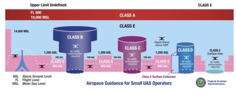
Airspace Guidance for Small UAS Operators chart above, according to air traffic laws
The remote PIC should be aware of the type of airspace in which they will be operating their sUA
AGL: above ground level
MSL: meters above sea level
FL: flight level
Class A (Alpha): Above. 18,000 MSL to 60,000 MSL.
Class B: (Bravo) Big. From surface to 10,000 MSL around busy airports, surrounded by shelves at increasingly high levels. Extends 30 nautical miles out.
Class C: (Charlie) Next largest airports (2 layers of shelves). From surface to 4,000 feet AGL within 5 nautical miles of the airport and from 1,200 ft AGL to 4000 ft AGL within 50-10 nautical miles of the airport.
Class D: (Delta). Smaller airports. (1 layer of shelves). From the surface to 2,500 ft AGL within 5 nautical miles of the airport. May have “bump-outs” to accommodate local conditions. You need clearance to fly here.
Class E (Echo): Everywhere. Begins at 1,200 ft AGL, 700 ft AGL in some, and all the way to the surface in some.
Back to Class E (Echo) in space.
Class G (Golf): Ground (typically stems to 1200 ft and in some places 700 feet). The take-off and landing space of aircraft.
Prohibited areas: blocks of airspace within which the flight of aircraft is prohibited. Examples include the airspace around the White House and U.S. Capitol building.
Restricted areas: denote the presence of unusual, often invisible hazards to aircraft such as artillery firing, aerial gunnery, or guided missiles. Penetration of restricted areas without authorization of using or controlling agency may be extremely hazaroud to the aircraft and its occupants. Per Part 107, entry into restricted airspace is not authorized without permission from the controlling agency.
Warning areas: contain the same hazardous activities as those found in restricted areas, but are located in international airspace
Alert areas: may contain a high volume of pilot training activites or an usual type of aerial activity. Pilots should be particularly alert when flying in these areas. Pilot of participating aircraft as well as pilots transiting the area are equally responsible for collison avoidance.
Military Operations Areas (MOAs): consist of airspace established for the purpose of separating certain military training activites from IFR traffic; pilots should exercise extreme caution while flying within an active MOA, prior to entering that they should contact the controlling agency for traffic advisories
Military Training Routes (MTRs): have been developed for use by the military for the purpose of conducting low-altitude, high-speed training; established below 10,000 MSL for operations at speed in excess of 250 knots
Aircrafts are requested to remain at least 2,000 ft above the surface of Natinoal Parks, National Monuments, Wilderness and Primitive Areas, and National Wildlife Refuges
Local Airport Advisory (LAA): an advisory service provided by Flight Service facilities, located on the landing airport, include local airport advisories, automated weather reporting with voice broadcasting, and a continuous Automated Surface Observing System (ASOS)
Topography
A geographic coordinate system was made to identify points on the surface of the earth
The equator is equidistant from the poles
The lines running east and west, parallel to the equator are called parallels of latitude, and are used to measure angular distance north or south of the equator (they are usto ed to measure distance north or south of the equator)
Lines called meridians of longitude are drawn from pole to pole at right angels to the equator
Any specific geographical point can be located by reference to its longitude and latitude
Airport Operations
When operating in the vicinity of an airport, the remote PIC must be aware of all traffic patterns and approach corridors to runways and landing areas. Sources for this data include the Sections Chart and the Chart Supplement U.S.
Remote PICs are prohibited from operating their sUA in a manner that interferes with operations and traffic patterns at airports, heliports, and seaplane bases
A manned aircraft may alter its flightpath, delay its landing, or take off in order to avoid an sUAS that may present a potential conflict or otherwise affect safe flight path
ATC towers are established to promote the safe, orderly and expeditious flow of air traffic
the tower controller will issue instructions for aircraft to follow the desired flight path while in the airport traffic area whenever necessary by using terminology
manned aircraft use this same terminology to self-announce position and intentions, consistent with recommended traffic advisory procedures
Remote PICs should avoid operating in the traffic pattern or published approach corridors used by manned aircraft
The remote PIC should operate the sUA in such a way that the manned aircraft pilot does not need to alter his or her flightpath in the traffic pattern or on a published instrument approach in order to avoid a potential collision
The FAA has the authority to approve or deny aircraft operations based on traffic density, controller workload, communication issues, or any other type of operations that could be potentially impact the safe and expeditious flow of air traffic in that airspace
When ATC authorization is required, it must be requested and granted before any operation in that airspace
The remote PICs should contact the appropriate ATC facility as soon as possible prior to any operation in Class B, C, and D airspace and within the lateral boundaries of the surface area of Class E airspace designated for an airport
When ATC authorization is not required, remote pilots should monitor the CTAF to stay aware of manned aircraft communications and operations
For recurring or long-term operations in a given location, prior authorization could include a Letter of Agreement (LOA) established with the controlling ATC facility for that airspace, to establish sUAS operating procedures
this LOA will outline the ability to integrate into the existing air traffic operation and may improve the likelihood of access to the airspace where operations are proposed
All areas on -airport that are used for certain cargo and passenger functions, including screening, must be a Security Identification Display Area (SIDA)
a SIDA is that portion of an airport within the United States, specified in the security program, in which individuals must display an airport-issued or approved identification and carry out other security measures
Airport Markings and Signs
Remote pilots should be familiar with standard airport markings and signs
Runway numbers and letters are determined from the approach direction
the number is the magnetic heading of the runway rounded to the nearest 10^degree (so 183 would become 18)
if there is more than one runway facing the same direction, the runway will have letters to differentiate between left (L), right (R), or center (C)
Stopways are found extending beyond some usable runways
these areas are marked by chevrons, and while they appear usable, they are suitable only as overrun areas
A closed runway which is unusable for various reasons and may be hazardous, even though it may appear usable, will be marked by an “X”
A basic runway may only have centerline markings and runway numbers
airports supporting instrument operations, higher volumes, and larger aircraft may use additional runway markings
Aircraft use taxiways to transition from parking areas to the runway
Taxiways are identified by a continuous yellow centerline stripe and may include edge markings to define the edge of the taxiway
When a taxiway approaches a runway, there may be a holding position marker; these consist of four yellow lines (two solid and two dashed), where the aircraft is to hold
beyond this point an aircraft is considered to be on the runway
There are 6 types of signs that may be found at airports
Mandatory instruction signs: red background with white inscription, which denote an entrance to a runway, critical area, or prohibited area
Location signs: black with yellow inscription and a yellow border, no arrows; they are used to identify a taxiway or runway location, to identify the boundary of the runway, or identity an instrument landing system (ILS) critical area
Direction signs: yellow background with black inscription; it identifies the designation of the intersecting taxiway(s) leading out of an intersection
Destination signs: yellow background with black inscription and arrows; these provide info on locating area like runways, terminals, cargo area, and civil aviation areas
Information signs: yellow background with black inscription; used to provide the pilot with info on areas that cannot be seen from the control tower, applicable radio frequencies, and noise abatement procedures; the airport operator determines the need, size, and location of these signs
Runway distance remaining signs: black background with white numbers; the numbers indicate the distance of the remaining runway in thousands of feet
Collision Avoidance
A key component to avoiding both manned and unmanned aircraft is active collision avoidance procedures
Scanning the sky for other aircraft is a critical factor in collision avoidance
Remote piltos and VOs must develop an effective scanning technique that maximizes visual capabilities
Effective scanning is accomplished with a series of short, regularly space eye movements
Each movement should not exceed ten degrees and each area should be observed for at least one second
Any aircraft that appears to have no relative motion and stays in one scan quadrant is likely to be on a collision course
If a target shows neither lateral nor vertical motion but increases in size, take evasive action
Another critical component in avoidance is avoiding operations near and under moored balloons and helicopters
The helicopter community performs their critical operations typically at 1,000 ft or less and often in wire/obstruction rich environment
Inflight Hazards
Although most sUAS can’t be operated in precipitation or other adverse weather conditions, remote PICs should be aware that status electricity buildup (P-static) can occur when an aircraft in flight comes in contact with rain, snow, fog, sleet, hail, volcanic ash, dust; any solid or liquid particles
In a short time, a substantial negative charge will develop on the skin of the aircraft
if the aircraft is not equipped with static dischargers, or has an ineffective static discharger system, when a sufficient negative voltage level is reached the aircraft may develop a phenomenon called a “corona,” a luminous manifestation of the static electricity accumulation
Such buildups may discharge from the extremities of the aircraft such as the wing tips, horizontal stabilizer, vertical stabilizer, antenna, propeller tips, etc
The visual discharge of static electricity is referred to as “St. Elmo’s fire”
P-static can also disrupt communications between the sUAS and the control station which may have a significant detrimental impact on the ability to control or retrieve the sUAS
Some sUAS use static dischargers to address this problem
Recently, the use of lasers has had more of an impact on all types of flight operations
Most skeletal structures are supported by guy wires, which are very difficult to see in good weather and can be invisible at dusk
Collision with wildlife often causes damage or loss of control to aircraft
Pilots should exercise caution when observing the presence of wildlife nearby
Chapter 3: Weather
Introduction
The remote PIC should always check and consider the weather conditions prior to and during every sUAS flight
Factors that affect sUAS performance and risk management include:
Atmospheric pressure and stability
wind and currents
uneven surface heating
visibility and cloud clearance
precipitation
The major source of all weather is the sun
Every physical process of weather, change, or variation of weather patterns is accompanied by or is a result of unequal heating of the Earth’s surface
Unequal heating of Earth’s atmosphere creates a large air-cell circulation pattern (wind) because the warmer air has a tendency to rise (associated with low pressure systems) and the colder air settles or descends (with high pressure systems) and replace the rising warmer air
Different surfaces radiate heat in varying amounts
The resulting uneven heating of the air creates small areas of local circulation called convective currents
Convective currents can cause turbulent air that has the potential to dramatically affect the remote PIC’s ability to control unmanned aircraft at lower altitudes
plowed ground, rocks, sand, barren land, pavement, and urban areas give off a large amount of heat and are likely to result in updrafts
Water, trees, and other areas of vegetation tend to absorb and retain heat and are likely to result in downdrafts
Wind
Wind and currents can affect sUAS performance and maneuvrability during all phases of flight
Be vigilant at low altitudes, in confined areas, near buildings or other manmade structures, and near natural obstructions (mountains). Consider:
obstructions on ground affect flow of wind
high winds may make it difficult to maintain a geographical position in flight and may consume more battery power or preclude aircraft control and recovery
Local conditions, geological features, and other anomalies can change the wind direction and speed close to the Earth’s surface
When operating close to buildings, winds blowing against the building could cause strong updrafts that can result in ballooning or a loss of positive control
The intensity of the turbulence associated with ground obstructions depends on the size of the obstacle and the primary velocity of the wind
The same condition is even more noticeable when flying in mountainous regions
While the wind flows smoothly up the windward side of the mountain and the upward currents help to carry an aircraft over the peak of the mountain, the wind on the leeward side does not act in a similar manner
As air flows down the leeward side of the mountain, the air follows the contour of the terrain and is increasingly turbulent
This tends to push an aircraft into the side of a mountain
The stronger the wind, the greater the downward pressure and turbulence become
Due to the effect terrain has on the wind in valleys or canyons, downdrafts can be severe
Even small hills or odd shaped terrain can have similar effects on local wind conditions
Air Masses and Fronts
When a body of air comes to rest on, or moves slowly over, an extensive area having fairly uniform properties of temperature and moisture, the air takes on these properties
The area over which the air mass acquires its identifying distribution of temperature and moisture is its source region
As this air mass moves from its source region, it tends to take on the properties of the new underlying surface
The trend toward change is called air mass modification
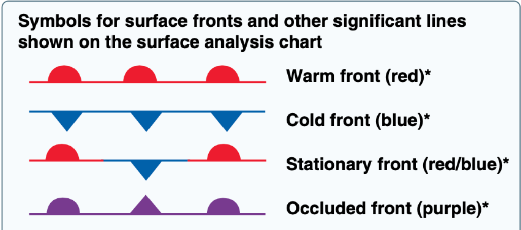
When an air mass that is different in such properties advances upon a dissimilar air mass, the division line is referred to as a front
A ridge is an elongated area of high pressure
A trough is an elongated area of low pressure
All fronts lie in troughs
A cold front is the leading edge of an advancing cold air mass
Cold fronts are often accompanied by poor weather ahead of the front, which passes relatively quickly
Once the front has passed, there is a wind shift and, due to the increased wind speeds, turbulence is common for a period of time
More severe cold fronts can produce thunderstorms, hail, and tornadoes
A warm front is the leading edge of an advancing warm air mass
Warm fronts move about half as fast as cold fronts and have more widespread effect on weather
they are often preceded by lowered ceilings, increased precipitation, and reduced visibilities
Remote PICs should be aware of ambient and approaching weather systems as they can significantly impact their operations and safety of flight
Frontal waves and cyclones (areas of low pressure) usually form on slower-moving cold fronts or stationary fronts
These types of systems are often accompanied by conditions that may be unfavorable to sUAS operations
The physical manifestations of a warm or cold front can be different with each front
They vary with the speed of the air mass on the move and the degree of stability of the air mass being overtaken
A stable air mass forced aloft will continue to exhibit stable characteristics, such as stratus clouds, calm air, steady precipitation, and poor visibility, while an unstable air mass forced to ascend will continue to be characterized by cumulus clouds, turbulence, showery precipitation, and good visibility
Frontal passage will be indicated by the following discontinuities:
a temp change
a continuous decrease in pressure followed by an increase as the front passes
a shift in the wind direction, speed, or both
Atmospheric Stability
Atmospheric stability is defined as the resistance of the atmosphere to vertical motion
A stable atmosphere resists any upward or downward movement
An unstable atmosphere allows an upward or downward disturbance to grow into a vertical (convective) current
Determining the stability of the atmosphere requires measuring the difference between the actual existing (ambient) temperature lapse rate of a given parcel of air and the dry adiabatic lapse rate
Because sUAS operate at low altitudes, it may seem as though lapse rate may not be a factor but the stability of the local air mass can have a significant impact on ambient conditions
Unstable air can often result in weather conditions unfavorable to sUAS operations
A stable layer of air would be associated with a temp inversion (a condition in which warm air is situated above cool or cold air)
Warming from below, on the other hand, would decrease the ability of an air mass
Unstable Air | Stable Air |
|---|---|
Cumuliform clouds | Stratiform clouds and fog |
Showery precipitation | Continuous precipitation |
Rough air (turbulence) | Smooth air |
Good visibility except in blowing obstructions | Fair to poor visibility in haze and smoke |
Visibility and Clouds
As in manned aircraft operations, good visibility and safe distance from clouds enhances the remote PIC’s ability to see and avoid other aircraft
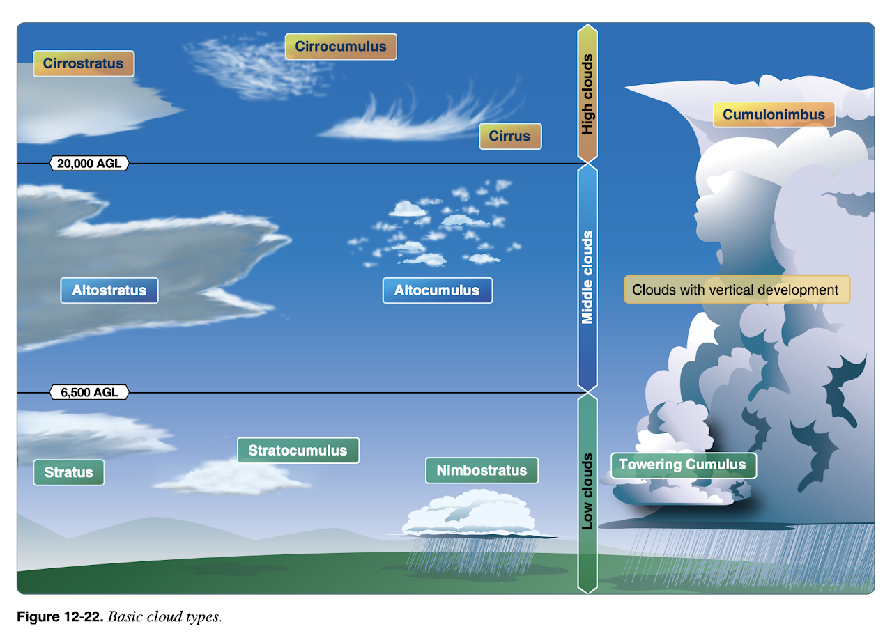
Ceiling & Cloud Cover
The ceiling is the height above the ground (AGL) of the lowest cloud layer that is Broken or Overcast. This is particularly important for crewed aircraft flying under visual flight rules because of weather minimums. For remote aircraft, remember that you must be at least 500ft below the base of a cloud (and 2,000ft or horizontal separation from any cloud).
In aviation weather reports – and particularly METARs & TAFs (below) – sky condition is reported in terms of 1/8s of sky coverage by clouds as follows.
Clear skies (SKC) ... 0/8 cloud coverage
Trace (FEW) ... 1/8 - 2/8 cloud coverage
Scattered (SCT) ... 3/8 - 4/8 cloud coverage
Broken (BKN) ... 5/8 - 7/8 cloud coverage
Overcast (OVC) ... 8/8 cloud coverage
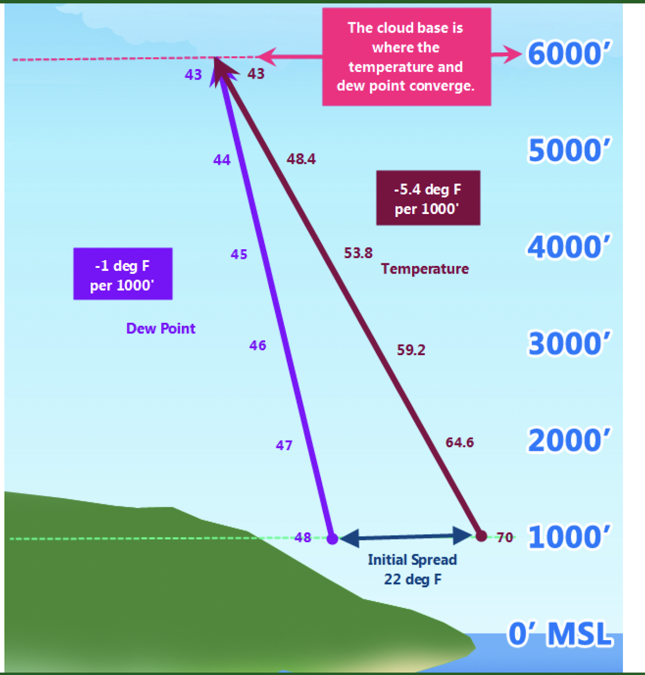
Estimating Cloud Base
You can estimte the height of the cumuliform cloud base by examining the temperature and dewpoint and considering the adiabatic lapse rate. Unsaturated air cools at roughly 5.4F (3.0C) per 1,000ft and dewpoint decreases by about 1F (5/9C) per 1,000ft. Visible moisture - the cloud base - forms when temperature and dewpoint are the same. So if we know the temperature and dewpoint on the ground, we can estimate the height at which they become equal.
(Temperature - Dewpoint) / 4.4F (2.2C) --> the approximate height above ground (AGL) in thousands of feet at which they are equal
The 4.4F (2.2C) is the difference between the cooling rate of the air and the decrease in dewpoint per 1,000ft.
Example: Suppose the temprature is 70F on the ground annd the dewpoint is 48F. Using this formula, we calculate (70-48)/4.4 = 5 x 1,000 = 5,000ft AGL is our estimate of the cloud base (6,000ft MSL in this example).
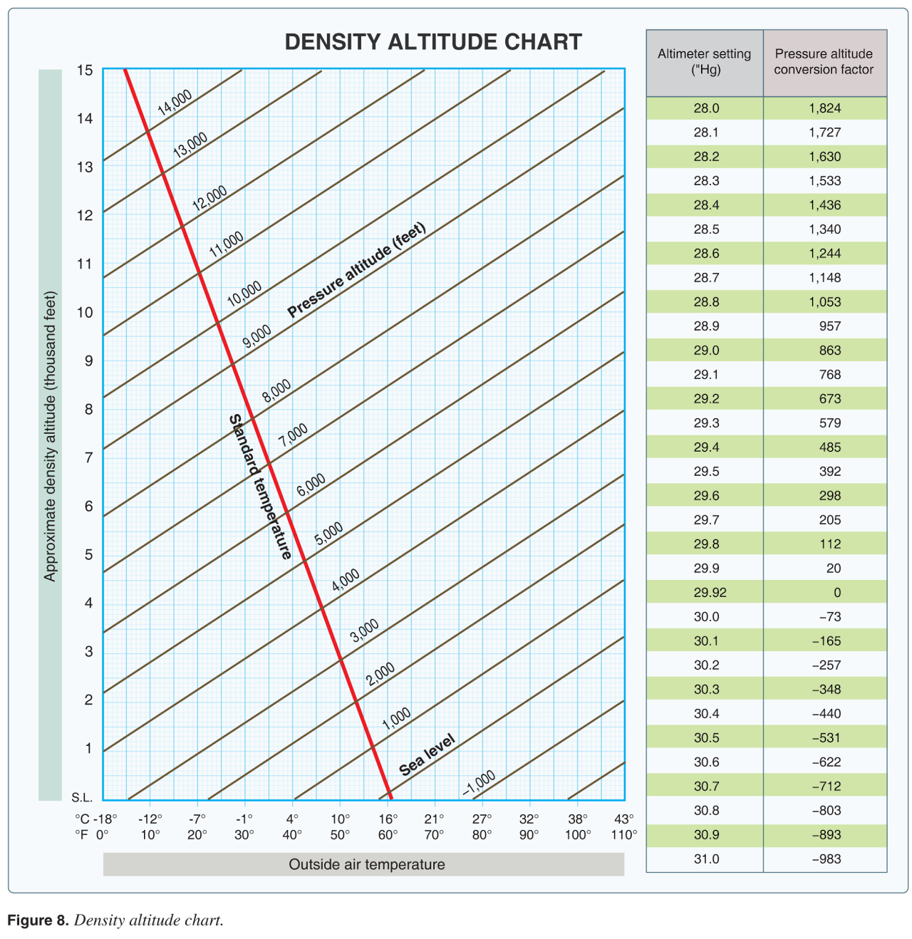
Altitudes, Altimeters, Density Altitude
Altitude is the height above the ground (AGL) or above mean sea level (MSL). Altimeters are devices that measure altitude and report them in MSL.
True altitude is the distance of the aircraft above MSL. Absolute altitude is the distance AGL.
You typically set the barometric pressure of your altimeter before you leave the airport and adjust it along the way. This allows the altimeter to display an indicated altitutde that is close to the true altititude. There is also something called pressure altititude which is what your altimeter would read if you set it to standard pressure (29.92" Hg).
There is a standard pressure (29.92" Hg) and temperature (15C) at sea level and a standard rate at which pressure and temperature change with altitude - that is the only time your altimiter's indicated altitude is the same as the true altitude.
Remote pilots don't need to get too caught up in this because of the altitude (AGL) limitations. BUT one thing you should know about is density altitude [ video - he uses the chart wrong - he should go up to 112' ]. That's pressure altitude corrected for non-standard temperatures. Basically, warm, moist air at high altitudes is less dense than cool, dry air at low altitude. So if it's very hot and humid out, your aircraft will perform as if it we at a higher altitude.
Example: You're on an airstrip at 1,200ft MSL. It's 90F. The barametric pressure is 29.7" mercury.
First, look at the table on the right side. Look for the altimeter setting of 29.7" then look over for the pressure altitude correction factor, which is 205ft. [ If your altimeter reads between the numbers on the chart, you'll need to do a linear interpolation. ]
Next, add that to the elevation of your airstrip to get 1,200 + 205 = 1,405. So just because of the lower than standard pressure, the airfield is as if it were at 1,405ft.
But it's also kinda hot. So now go to the bottom of the graph on the left and find 90F. Follow the blue line up until you hit the 1,405 pressure altitude (black diagonal lines). Well, there is no 1,405 line so you'll need to estimate where it would be between the 1,000ft and 2,000ft lines. It's not going to be exact. Then follow the blue lines straight to the left until you hit the Y-axis and that's your density altitude - about 3,600ft.
So your aircraft is going to perform as if it were at an altitude of 3,600ft MSL.
Weather Information & Forecasts
The FAA's Pilot's Handbook of Aeronautical Knowledge covers aviation weather services in detail (Chapter 13). You should become familiar with this chapter (embedded below). Some of it is more relevant to crewed flight than Part 107 remote flight. There are several key bits of information that you'll want to understand as a remote pilot. As a remote pilot, you are typically concerned with the weather in a relatively small area, whereas pilots of crewed aircraft want to know how the weather will change as they fly large distances.
Unless noted otherwise, images are from the Pilot's Handbook of Aeronautical Knowledge.
Weather Briefings and Forecasts
A good place to get weather information is 1800wxbrief.com. You can create a free account and look at weather briefs focused on an airport near where you will fly - this is called an area brief. These briefings will include Airman's Meterological Information (AIRMET) and Significant Meterological Information (SIGMETS) (think icing, dust storms, thunderstorms, and such).
Some terminolgy they might ask you abotut on the test is the type of weather briefing you are looking at.
Outlook briefing - flight is 6 or more hours from now
Standard briefling - a complete briefing for a flight within the next 6 hours
Abbreviated briefing - you're only asking about a few items, because you've gathered information elsewhere
Note that your sessions on 1800wxbrief are documented on the system, which provides some evidence of due diligence in the event of a mishap.
The National Weather Services' Aviation Weather Center is very comprehensive and also freely available. AIRMETS and SIGMETS are also available here.
UAV Forecast is designed for remote pilots and has a web interface as well as apps for Android and iPhone. Apps like this can give you weather where you're standing or for anyplace you search.
If you have a radio capable of tuning civil aviation frequencies [ 118.0 - 136.975 MHz ] and you are near an airport, you can listen to some of the automated weather reports - AWOS / ASOS / ATIS - that include wind speed and direction, barometric pressure, and density altitude. Many airports also have a phone number you can call to listen to those reports. For example, for Triangle Executive (KTTA), dial 919.708.5382. These numbers can be found on AirNav.com or in the Chart Supplements for each airport.
METARs and TAFs
The FAA has a shorthand for weather reports at airports available to pilots. You're expected to be able to read these reports for the Part 107 exam.
Meterological Aerodrome Reports (METARs) relate current conditions and Terminal Area Forecasts (TAFs) relate predictions for the next 24 hours. There are numerous applications, such as Avia Weather, that decode the shorthand. The Aviation Weather Center TAF (Products / TAF Data) or METAR (Products / METAR Data) pages will also decode for you. But you're expected to know the code for the exam. One fun way to learn the code is to get one of those applications, look at the coded version, and then check your decoding against the official decoding. The FAA key to decoding is below (source).
Chapter 4: Preflight Considerations
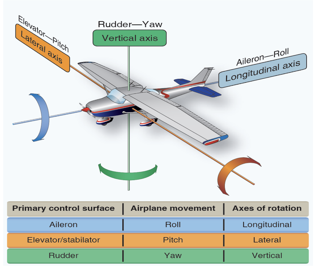
Pitch (nose up or down), roll (left or right wing up or down for banked turns), and yaw (rotation round the vertical axis) on fixed wing aircraft (pictured above) have equivalents on quadcopters.
For a quacopter, pitch is controlled by moving the right stick forward (nose down) or backward (nose up) causing the aircraft to move forward or backward. Roll is controlled by moving the right stick left (tilt left) or right (tile right) causing the aircraft to move left or right. Yaw is contolled by moving the left stick left or right, causing the nose of the aircraft to rotate left or right. Remember, all of this happens because of differential speeds of the propellers.
Speed & Altitude
Key points ...
Maximum allowable ground speed of your aircraft is 87knots (100mph)
Maximum allowable altitude is 400ft AGL ... unless flown with a 400ft radius of a structure, in which case it can be flown more than 400ft above the structure's uppermost height
Ways to determine speed include ...
GPS on the aircraft that reports ground sped
Dead reckoning: measure time flying between points of known distance and do the math
Use a radar gun
Ways to determine altitude include ...
Altimeter or GPS on the aircraft
Compare to height of known structure or terrain
Measure 400ft on the ground to get perspective on how far it is and the visual size of the aircraft at that distance
Loading and Weight & Balance
Key points ...
If you overload your aircraft (exceed maximum gross weight) you will not have enough lift to take off or to maintain flight
Excess weight reduces flight performance, including climb rate, maximum altitude (MSL), endurance, and maneuverability
If you push the center of gravity of your aircraft outside a safe envelope, you may not be able to control the aircraft. In any event, your aircraft will be less stable.
The center of gravity can change during flight (e.g., if you're taking on or jetissoning materials) and you must ensure it is always within the safe envelope
Look to information from the manufacturer about gross weight and calculating center of gravity
Load also increases when turning the aircraft - see load factor charts
Visit the FAA's Weight & Balance Handbook for many more details.
Stalls
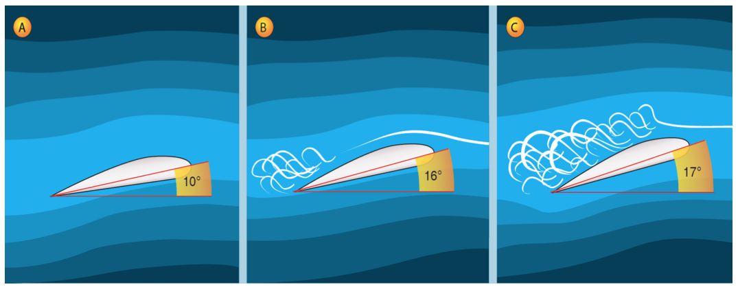
Airfoils - wings, propellors, rotors - create lift by moving through the air.
The angle at which an airfoil moves through the air - defined as the angle between the airfoil chord and relative wind - is called the angle of attack.
When the angle of attack increases into the 18-20 degree range - the critical angle of attack - the movement of air over the top of the airfoil becomes turbulent and lift is lost.
This is a stall and the aircraft will be pulled by gravity toward the ground.
The angle of attack must be reduced (nose down) to regain lift.
A stall can occur at any airspeed or altitude once the critical angle of attack is exceeded.
Vortex Ring State
Rotor-type remote aircraft are most likely to stall when descending rapidly in a vertical straight line.
The turbulence when doing this can disrupt lift through a phenomenon called vortex ring state - basically, the aircraft is descending into it's own downdraft and loses lift.
To avoid a vortex ring state, descend at a reasonable rate and with some lateral motion so that the aircraft is always moving out of the turbulence it creates.
To recover, add forward or sideways motion; do NOT try to ascend out of it because that will just make things worse.
Many modern drones have programming to prevent descent rapid enough to cause this problem.
Other Performance Factors
Density altitude ("thin" air), wind (changes power requirements), cold (ice formation), and excessive heat (overheating) can all reduce the performance of you aircraft
As remote pilot in command, it is your responsibility to consider these factors
Chapter 5: Operations
As remote pilot in command, you are fully responsible for ensuring a safe operation.
Preflight Inspection & Planning
Develop a preflight inspection routine to be carried out before each flight, even if the flights are one after the other. It should include all components of the Umcrewed Aircraft System, including aircraft, controllers, batteries, cameras, antennas, and so forth.
Use the manufacturer's recommendations, if they have any, and develop your own guidelines to ensure that all components are safe to use.
Use checklists like the Flight Risk Assessment Tool to evaluate the mission itself.
Gather as much information as you can about the site where you'll be flying, the weather, who to call in an emergency, and so forth.
Make sure you and your crew are qualified and fit for the mission - see Human Factors & Aviation Decision Making.
There are several example checklists in the Resource Library.
Communications
Learn about aviation communications by reading the text and listening in on liveatc.net. Some small airports - like Raleigh Executive Jetport (KTTA) that we visited - have observation areas with radios so that you can hear the pilots talking.
The Airspace & Airports page of this website has some sample communications (for a landing pattern).
Monitor the Common Traffic Advisory Frequency (CTAF) if you are operating near an airport. You can find the CTAF on aeronautical charts, chart supplements, or through AirNav. The default frequency if none are published for the airport is 122.9 MHz.
Remember that ATC permission is required before flying in controlled airspace in almost all circumstances. Even if you're going to operate near a Class G airport, I highly recommend contacting the airport manager to talk with them about your operation before beginning - it can save you all sorts of headaches. Aviation is NOT an endeavor in which it is better to seek forgiveness than permission.
Remote Aircraft Control Frequencies
Most small remote aircraft operte at 2.4 GHz (to transmit video and photos) and 5.8 GHz (for control), both of which are regulated by the Federal Communications Commission.
Both of these frequencies are also used for wireless computer networks (WiFi).
Thus, your aircraft is subject to interference from these networks and can also be blocked by buildings and other structures between the control station and the aircraft.
Crew Resource Management
If more than one person is involved in the operation, that will need to be managed. Please visit the Crew Resource Management page in the Basic Piloting Skills section for details.
Human Factors & Aeronautical Decision Making
Remote pilots do not need an aviation medical certificate BUT they may not participate in a mission as Remote Pilot in Command, Visual Observer, or manipulator of the controls if they know or have reason to believe they have a physical or mental condition that would prevent safe execution of their duty.
Common factors that may affect a mission participant include ...
Uncorrected vision deficiency
Fatigue (acute, chronic)
Dehydration, heat exhaustion, and heat stroke
Hypothermia
Stress and hyperventilation
Aeronautical Decision Making
Sound decisions are at the heart of aviation safety. The FAA defines aeronautical decision making as a continuous process, including pre-flight, in-flight, and post-flight.
Key factors in aeronautical decision making are
Noting changes that have (or haven't, but should have) occurred
Knowing your biases
Being honest about your abilities
Setting and sticking to personal minimums based on your skills
Resisting external pressure, such as saving money or time, get-there-itis, and fear of embarassment
Have a Plan B (and C) and use it if needed
Evaluate the outcome of your decisions and feed that back into your thinking
IMSAFE
IMSAFE helps pilots assess their condition before flying
Illness - So you have any illness that might affect the flight. Think carefully about the conditions under which the flight will be conducted. For example, is it allergy season for you?
Medication - Are you taking a medication that could cause your concentration to lapse, or in other ways interfere with a safe flight? What are the effects of that allergy pill you just took?
Stress - Be aware of pyschological stresses. Are you worried about something? Are you distracted, constantly thinking about something else? If you can't focus on the flight, maybe you shouldn't fly.
Alcohol (& other such substances) - Just don't. There are specific rules you need to know for the test, but if you're even thinking about measuring yourself against those rules, you probably shouldn't fly.
Fatigue - being tired - chronically or acutely - can affect your physical and mental abilities. Get good sleep and avoid scheduling flights when you expect you'll be tired (how about those mid-afternoon doldrums?)
Eating / Emotion - This letter is used in 2 different ways. Eat well so that you have the reserves to carry you through the flight. And don't forget to stay hydrated. Emotion is related to stress - are you in a good emotional state that will allow you to stay focused on flying?
3-P Model
One model used is the 3-P Model:
Perceive - Gather all information relevant to the mission. In particular, indentify potential hazards.
Process the information from the perspective of flight safety and determine a best course of action.
Perform - Implement the best course of action. The outcome becomes more information to be perceived, so the process is continuous.
5-P Model
The 5-P model is another approach:
Plan - weather, route, fuel
Plane - adequecy for mission
Pilot - proficiency, health
Passengers - involve, brief
Programming - plan ahead for avionics and other automation
PAVE Model
The PAVE model is another flight risk assessment tool.
Pilot. Start here - if you're not fit to fly, the mission is over. Be careful to avoid get-there-itis, the excessive focus on getting to the destination or completing the mission right now, despite risks.
Aircraft. Know your aircraft and be sure to do a pre-flight assessment.
enVironment. Understand the environment in which you'll operate: weather, time, air traffic.
External pressures. Be aware of and resist external pressures to conduct the mission in the face of high risks. And avoid setting yourself up for this. For example, planning to arrive at a location just in time for an important meeting.
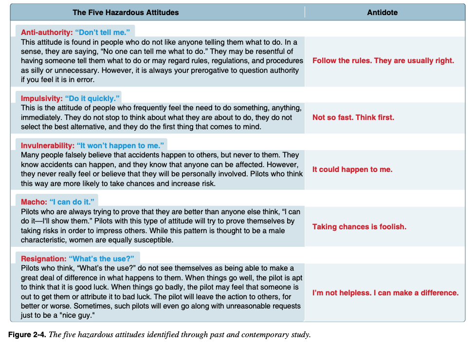
Hazardous Attitudes
The FAA highlights 5 hazardous attitudes, how they can get you into trouble, and how you can overcome them. [I need to make this chart accessible]
Abnormal Situations & Emergencies
An abnormal situation is one that was not intended or planned for, but that do not pose imminent danger or collision or harm. Examples are lost links, lost GPS, having to land at an alternate landings site.
Emergencies place people or property in imminent danger of harm. Examples include flyaways and battery fires.
With all abnormal and emergency situations, your first recourse is to follow aircraft manufacturer recommendations.
Lost Link
Control of the aircraft is through radio communication between the aircraft and the control station. An interrepution in that communication is called a lost link. Note that a lost link is not a flyaway and, on its own, is not considered an emergency.
Many drones have pre-programmed lost link procedures designed to allow you time to re-establish communication. Look to your user manual to know what your aircraft will do. For example, the DJI Mini-2 will return to home if the link is lost. Be sure to set the return-to-home altitude high enough to avoid obstacles. Also, brief your crew on lost link procedures.
Steps to take in the event of a lost link include ...
Keep visual contact with the aircraft
Make sure the controller is still powered on
Move closer to the aircraft
Try to initate the return-to-home procedure manually
Contact ATC as needed
Once (if) the link is re-established, land the aircraft as quickly as possible.
GPS Loss
As remote pilot in command, you should be ready to control your aircraft manually in the event GPS becomes unavailable. This is abnormal, but also not an emergency.
Even if you are flying manually already, loss of GPS can result in the inability of the aircraft to hover in a stable way, especially if there are winds. You may continue to operate the aircraft without GPS, if GPS is not mission critical. If you are having trouble controlling the aircraft, you should land as quickly as possible, including at an alternative landing site.
Before flying, check NOTAMS for potential GPS outages.
Flyaway
Flyaways are when aircraft control is lost - often starting as a lost link - and cannot be regained. This is an emergency. If pre-programmed failure routines are not properly set or also fail, the aircraft just flies off and will keep flying until it runs out of power. Then it will crash. Some aircraft allow you to turn off the propellers in mid-flight. Consider whether this is a better option than allowing the aircraft to keep flying away.
Take note of the battery level, speed, and direction of the aircraft when the flyaway begins. This will allow you to estimate where it will run out of power.
Contact ATC if you are in or near controlled airspace. Use maps to pinpoint potential crash sites.
You may chose to contact local authorites, though they will be unlikely to do anything about the situation until the aircraft crashes.
Flight Termination
Flight termination is ending a flight carefully and deliberately.
As part of planning, you should know how you will terminate a flight if you encounter abnormal or emergency situations that you feel are dangerous or from which you cannot recover.
Know where and how you will land and what you will do once you have landed the aircraft.
Collision
If your aircraft collides with anything, release all controls sticks right away.
If the aircraft stabilizes, fly away from the object you collided with and land as soon as possible.
If the aircraft remains unstable, strongly consider manually shutting down the rotors and allowing it to fall from the sky.
In making this decison, evaluate what is directly underneath vs where the aircraft is otherwise going.
Your main goals are to protect people, other living things, and property.
Battery Fires
Most modern uncrewed aircraft are powered by lithium batteries. These batteries are highly flammable, can self-ignite if overcharged, overheated, mishandled, defective, or damaged.
Batteries should be stored safely such that they cannot be short-circuited (i.e., metal cannot connect battery terminals). For extra safety, store them in a fire-proof battery bags.
When these batteries do catch fire, it's difficult to stop. Water does not help. Use a Type D extinguisher designed for chemical and metal fires. Cover the burning batteries with sand or soil to smother the fire.
2024 Test Prep Remote Pilot Notes
Introduction
To take an FAA Airman Knowledge Test, all applicants must establish an FAA Tracking Number by creating a profile in the Integrated Airman Certification and Rating Application system at iacra.faa.gov.
Then visit faa.psiexams.com to register for your exam and take FAA-created practice tests to become familiar with the computer testing platform.
Answer every question because some may later be marked “no right answer,” and you’ll be given full credit if you choose one.
Chapter 1: Regulations
The rules about small unmanned aircraft systems are outlined in the National Airspace System (NAS) for purposes OTHER than hobby and recreation
these rules are specified in Title 14 of the Code of Federal Regulations (14 CFR) Part 107, “Small Unmanned Aircraft Systems”. This part addresses sUAS classification, certification, and operational limitations and applies to the operation of certain civil small unmanned aircraft within the NAS.
A small, unmanned aircraft includes the criteria:
weighs less than 55 pounds (25 kg), including everything that is onboard/attached to aircraft (not 55 pounds and below! LESS THAN 55 pounds, like 49.999!)
are operated without the possibility of direct human intervention from within or on the aircraft
Different terms for small, unmanned aircraft: UA, UAS, and sUAS
an sUAS includes the unmanned aircraft itself and its associated elements that are required for safe operation, such as communication links and components that control the aircraft
Control station (CS): an interface used by the remote pilot or the person manipulating the controls to control the flight path of the sUA
Corrective lenses: spectacles or contact lenses
Model aircraft: a UA that is:
capable of sustained flight in the atmosphere
flown within the visual line-of-sight (VLOS) of the person operating the aircraft; and
flown for hobby or recreational purposes
Person manipulating the controls: a person other than the remote PIC who is controlling the flight of an sUAS under the supervision of the remote PIC
Public aircraft: means any of the following
an aircraft used only for the U.S. government
and aircraft owned by the government and operated by any person for purposes related to crew training, equipment development, or demonstration
an aircraft owned by the government of a state, the D.C., or a territory or possession of the U.S., etc
an aircraft exclusively leased for at least 90 continuous days by the government of a state, the D.C., etc
an aircraft owned or operated by the armed forces or chartered to provide transportation or other commercial air service to the armed forces
Remote pilot-in-command (remote PIC or remote pilot): a person who holds a remote pilot certificate with an sUAS rating and has the final authority and responsibility for the operation and safety of an sUAS operation conducted under Part 107
Small unmanned aircraft (sUA): a UA weighing less than 55 pounds and can be flown without the possibility of direct human intervention from within or on the aircraft
Small unmanned aircraft system (sUAS): a sUAand its associated elements (including communication links and the components that control the sUA) that are required for the safe and efficient operation of the SUA in the NAS
Unmanned aircraft (UA): an aircraft operated without the possibility of direct human intervention from within or on the aircraft
Visual observer (VO): a person acting as a flightcrew member who assists the sUA remote PIC and the person manipulating the controls to see and avoid other air traffic or objects aloft or on the ground
Remote Pilot Certification
Pilot certifications listed the certification level which defines the privileges and limitations of that certificate holder, such as remote pilot, private pilot, flight instructor, etc.
it will include the category of aircraft as well in which the pilot is qualified to fly it
A SUA is a “rating”
A person acting as a remote PIC of an sUAS in the NAS under Part 107 MUST obtain a Remote Pilot Certificate with an sUAS rating issued by the FAA before operation
Requirements for a Part 107 Remote Pilot Certificate:
be at least 16
be able to read, speak, write, understand English
be in a physical and mental condition that would not interfere with the safe operation of sUAS
fulfill training and testing requirements
renew every 24 months
The application for the test must be submitted to a Flight Standards Office (FSDI), a designated pilot examiner (DPE), an airman certification representative for a pilot school, a certified flight instructor, or another person authorized by an FAA Administrator to process it
You must pass a background check
Remote Pilot Privileges
The remote pilot must:
be designated before each flight (but can change during the flight)
ensure that the operation poses no undue hazard to people, aircraft, or poverty in the event or loss of control of the aircraft for any reason
operate the small unmanned aircraft to ensure compliance with all applicable provisions and regulations
Being able to safely operate the sUAS relies on the physical and mental capabilities of the remote PIC, person manipulating the controls, VO, and any other direct participant in sUAS operation
Another certified pilot may take over the controls if he or she is certified , both capable of maintaining VLOS of the sUAS, and without loss of the operation
Supporting Crew Roles
A person without a Remote Pilot Certificate may operate a sUAS as along as he or she is directly supervised by a remote PIC and the PIC can take over if something goes wrong (see Part 107)
The remote PIC can take over the controls by:
using a “buddy box” system that uses two control stations (CS): one for the person manipulating the flight controls, and one for the remote PIC that allows the remote PIC to override the other CS and immediately take controls of the sUAS
or the remote PIC standing close enough to the person manipulating the controls to take control
employ the use of an automation system whereby the remote PIC could immediately engage that system to put the sUA in a pre-programmed “safe” mode
An autonomous operation is when the autopilot on board the sUA performs certain functions without direct pilot input
the remote PIC must still be able to change routing or altitude
The role of VOs is to alert the rest of the crew about potential hazards during sUAS operations
they are optional
they must be positioned in a location where they are able to see the sUAS continuously and sufficiently to maintain VLOS, and possess a means to effectively communicate the sUAS position and the position of other aircraft to the remote PIC and person manipulating the controls
Falsification, Reproduction, or Alteration
The FAA may take appropriate action against an sUAS owner, operator, remote PIC, or anyone else who fraudulently or knowingly provides false records or reports, or otherwise reproduces or alters any record, reports, or other info for fraudulent purposes
Accident Reporting
The remote PIC must report any sUAS accident to the FAA within 10 days if:
serious injury to any person or any loss of consciousness
damage to any property, other than the small unmanned aircraft, if the cost is greater than $500 to repair/replace property
The report must be submitted to FAA Regional Operations Center (ROC) or FSDO electronically (faa.gov/uas) or by phone
The report should have:
sUAS remote PIC’s name and contact info
sUAS remote PIC’s airman certificate number
sUAS registration number issued to the aircraft, if required (FAA registration number)
location of the accident
date of the accident
time of the accident
person(s) injured and extent of injury
property damaged and extent of damage
description of what happened
A serious injury qualifies as Level 3 or higher on the Abbreviated Injury Scale (AIS) of the Association for the Advancement of Automotive Medicine, used by medical personnel
Certain sUAS accidents must also be reported to the NTSB
FAA Inspections
You must carry, in case of an FAA inspection, the following documentation:
Pilot certificate
Aircraft registration
Any necessary waiver or exemption
other documentation related to the operation
sUAS Registration
Owners must register the sUAS if it greater than 0.55 pounds, less than 55 pounds, and operated under the provisions of Part 107
The aircraft must be registered by someone over the age of 13
A Certificate of Aircraft registration expires 3 years after the date of issue unless it is renewed
An sUAS operation requires a Foreign Aircraft Permit if it involves a civil aircraft that is:
registered in a foreign country
owned, controlled or operated by someone who is not a U.S. citizen or permanent resident
Before operation, mark the sUAS to identify that it is registered with the FAA. The marking must be:
a unique identifier number
legible and durable
visible
Remote Identification (Remote ID)
Remote ID is the ability of a drone in flight to provide ID and location info via radio frequency (ex: Bluetooth) that can be received by other parties. This includes:
a unique identifiers for the drone
the drone’s latitude, longitude, geometric altitude, and velocity
an indication of the latitude, longitude, and geometric altitude of control station (standard) or takeoff location (broadcast module)
A time mark
Emergency status (standard remote ID drone only)
No person may operate a sUA within the airspace of the U.S. unless it meets the requirements of 14 CFR unless authorized by FAA
Standard remote ID broadcasts ID and location info about the drone and its control station
A remote ID broadcast module is an alternative remote ID device that broadcasts ID and location info about the drone and its takeoff location in accordance with the remote ID rule’s requirements
The Certificate of Aircraft Registration of the unmanned aircraft used in the operation must include the serial number of the remote ID broadcast module, or the serial number of the unmanned aircraft must be provided to the FAA in a notice of ID prior to the operation
Operations without remote ID may also be conducted in an FAA-recognized ID area (FRIA)
Preflight Action and Inspection
The remote PIC must complete a preflight familiarization, inspection, and other actions, such as crew-member briefings, prior to beginning flight operations. Like so:
assess the operating environment including local weather conditions, local airspace, flight restrictions, the location of persons and property on the surface, and other ground hazards
inform any supporting crewmembers about the operation and their roles (such as operating conditions, emergency procedures, contingency procedures, roles and responsibilities of each person involved in the operation, as well as potential hazards)
Inspect the sUAS to see that it is in a condition for safe operation (control links between control station and the small unmanned aircraft are working properly, enough power, objects carrier are secure,
Maintain documents required in the event of an FAA inspection
Carriage of Hazardous Material
A sUA cannot carry any hazardous material
Hazardous material is anything the Secretary of Transportation has determined is capable of posing an unreasonable risk to health, safety, and property when transported
Operation at Night
For operations under civil twilight and night, the sUAS must be equipped with anti-collision lights that are capable of being visible for at least 3 SM
The PIC may momentarily reduce light if it impacts night vision
Civil twilight is the period of time before sunrise and after sunset when the sun is not more than six degrees below the horizon
14 CFR Part 1 defines night as the time between the end of evening civil twilight and beginning of morning civil twilight
Civil twilight lasts about 30 minutes after sunset or before sunrise
Visual Line of Sight (VLOS)
The sUAS must remain with VLOS of flight crewmembers
without the aid of any device other than corrective lenses (glasses/contacts)
The sUA must be operated closely enough to the CS to ensure visibility requirements are met during small unmanned aircraft operations
For operational necessity, the remote PIC may maneuver the sUA so he or she loses sight of it briefly (ex: looking at the edge of a rooftop)
Operating Limitations
The sUAS must be operated in accordance with the following:
cannot be flown faster than a ground speed of 87 knots (100 mph)
Cannot be flown higher than 400 ft above ground (unless flown within a 400-ft radius of a structure and not flown higher than 400 ft above the structure’s immediate uppermost limit)
Crewmembers must operate within the following limitations:
minimum visibility, as observed from the location of the control station, must be no less than 3 SM
minimum distance from clouds must be no less than 500 ft below a cloud and 2,000 ft horizontally from a cloud
Right-of-Way Rules
No person may operate a sUA that interferes with operations and traffic patterns at any airport, heliport, or seaplane base
The remote PIC has to yield right-of-way to all other aircraft, manned or unmanned, and avoid hazards
referred to as see and avoid
To satisfy this, the remote PIC must:
know the location of flight path of his or her sUA at all times
be aware of other aircraft, persons, property nearby
be able to maneuver the sUA to
avoid a collision
prevent other aircraft from having to take evasive action
Avoid operating anywhere where the presence of his or her sUA may interfere with operations at the airport, such as approach corridors, taxiways, runways, and helipads
Yield right-of-way to all other aircraft, including aircraft operating on the surface of the airport
First-person view camera cannot satisfy this requirement, but VOs can
Operation Over Human Beings
No person may operate an sUAS over a human being unless:
That human being is directly participating in the operation of the sUAS
They are under a covered structure/stationary vehicle that gives protection from a falling sUAS
the operation meets the requirements of at least one of the operational categories specified in Sub-part D of Part 107 outlined below:
To conduct Category 1 Operations the sUAS must meet the requirements of 107.110
To conduct Category 2 Operations the sUAS must meet the requirements of 107.115
To conduct Category 3 Operations, the sUAS must meet the requirements of 107.125
To conduct Category 4 Operations the sUAS must meet the requirements of 107.140
There are 4 categories of operations over people.
Category 1: The aircraft weighs no more than 0.55 pounds AND has no exposed rotating parts (that would cause lacerations). The Tello aircraft meets these criteria, with the propellor guards installed. Note that if you intended sustained flight over open air assemblies of people, the aircraft must also have remote ID. The Tello as configured out of the box fails on that account (it has no remote ID).
Category 2: "... must not be capable of causing an injury to a human being that is more severe than an injury caused by a transfer of 11 ft-lbs of kinetic energy from a rigid object." This is to be certified by the manufacturer or modifier of the aircraft. As in category one, there must be no exposed rotating parts that can cause laceration. Remote ID is also required.
Category 3: This increases the allowable transfer of energy to 25 ft-lbs; prohibits flying over open-air assemblies of people; and requires the operation to be over a restricted access area in which all people present are aware of the UAS operation OR the pilot doesn't maintain sustained flight over people unless they are protected by a structure or inside a stationary vehicle. Remote ID is not mentioned explicitly for this category of operations but remote ID is required for operations except in very specific areas (FAA-Recognzed Identification Areas (FRIAs)), so you should assume it is required. There are a few AgEagle drones certified for Category 3.
Category 4: If you don't fit into one of the above 3 categories, you must get an airworthiness certification - just like for crewed aircraft - for your drone from the FAA. Remote ID is required.
No person may operate an sUAS over a human inside a moving vehicle unless it means 1 of 4 operational categories for operations over people
To conduct Cat 1: the sUAS must remain within or over a closed- or restricted-access site, all human beings made aware that an sUAS may fly over them, and the sUAS must not maintain sustained flight over the moving vehicle
To conduct Cat 4: the sUAS must have an airworthiness certificate and be operated in accordance with the operating limitations specified
For all operations conducted under Cat 2 and 3 the sUAS must meet a means of compliance (MOC) and be listed on a current Declaration of Compliance (DOC)
the MOC must consist of a test, analysis, and inspection of procedures for the sUAS detailing how the sUAS meets the requirements for Cat 2 and Cat 3
it should include conditions, environments, and methods, as applicable
this info needs to be submitted along with a compliance explanation of how application of the MOC fulfills the requirements
Operation from Moving Vehicles or Aircraft
Part 107 allows sUAS operation from a moving land or water vehicle over a sparsely populated or unpopulated area, but no controlling it from an aircraft
sUA that are transporting another person’s property for compensation or hire may not be operated from any moving vehicle
Operations from moving vehicles are subject to the same restrictions that apply:
PIC must maintain VLOS
the VO and PIC must maintain communication
no reckless operation (don’t drive while controlling it)
Privacy and Other Considerations
No person may operate a drone in a careless manner that may endanger another person or property
Part 107 also prohibits allowing an object to be dropped from a drone in a way that causes undue hazard to persons or property. Such as:
operations that interfere with manned aircraft operations
operating an sUAS over persons not directly participating in the operation
loading the sUAS beyond its capabilities where it loses control
You may operate an sUAS to transport another person’s property for compensation if you comply with also:
the total weight of the sUA is below 55 pounds
the sUAS operation must be within bounds of a state
no items may be dropped from the aircraft that damage person or property
you may not operate it from a moving vehicle or vessel
carriage of hazardous material is not permitted
stay in VLOS of the pilot
Alcohol and Drugs
Part 107 does not allow operation of an sUAS if the remote PIC or VO is unable to carry out duties
ex: drugs, alcohol, over-the-counter medication
A refusal to submit to a test to indicate the percentage of blood alcohol is grounds for:
denial of an application for a Remote Pilot Certificate with a sUAS Rating for up to 1 year
suspension or revocation of a Remote Pilot Certificate with an sUAS rating
Change of Address
A remote PIC must update the FAA Airman’s Certification Branch within 30 days if they move
Or their privileges are taken away
Waivers
A remote PIC must apply for a waiver if they determine the operation cannot be conducted within the regulatory structure of Part 107
proposing a safe alternative
The Administrator may issue a CoW authorizing a deviation from any regulation specified in 14 CFR as listed below:
operation from a moving vehicle or aircraft (but not for compensation)
anti-collision light required for operations at night
VLOS during operation (not for compensation)
visual observer
operation of multiple small unmanned aircraft systems
yielding right of way
operation over people
operation in certain airspace
operating limitations for small unmanned aircraft
operations over moving vehicles
After submitting your CoW application and supporting documentation via faadronezone.faa.gov, you will receive notification stating reasons for denial or approval
then you get a complete form with direct provisions
Chapter 2: National Airspace System
Introduction
The Remote Pilot Certificate with an sUAS Rating will allow operation of an sUAS in the National Airspace System (NAS)
There are 2 categories of airspace or airspace areas:
Regulatory (Class A, B, C, D, and E airspace areas, restricted, and prohibited areas)
Nonregulatory (Class G airspace, Military Operations Areas, warning areas, Alert Areas, controlled firing areas)
Class A, B, C, D, and E airspace areas are referred to as controlled airspace
Class G airspace areas are referred to as uncontrolled airspace
The Chart Supplement U.S. determines what kind of airspace, ATC facilities, and traffic you can expect near the airport closest to your operations
The aeronautical map most commonly used by manned pilots are the Sectional Aeronautical Chart and the Terminal Area Chart (TAC)
NOTAMs
Notices to Air Missions (NOTAMs) provide the most current info available and can be found by visiting faa.gov
They provide time-critical info on airports and changes that affect the NAS
sUAS remote PIC should check for NOTAMs before each flight to determine if there are any applicable airspace restrictions
NOTAM info is classified into 5 categories:
NOTAM (D) or distant
transmitted with hourly weather reports
issued every 28 days in Notices to Air Missions publication
Flight Data Center (FDC) NOTAMs
issued by the National Flight Data Center (NFDC) and contain regulatory info such as temporary flight restrictions or an amendment to instrument approach procedures
issued every 28 days in Notices to Air Missions publication
An FDC NOTAM will be issued to designate a temporary flight restrictions (TFR). The NOTAM will begin with the phrase “FLIGHT RESTRICTIONS” followed by the location of the temporary restriction, effective time period, area defined in statute miles, and altitudes affected. It will also include the FAA coordination facility and telephone number, the reason for the restriction, and any other info deemed appropriate
pointer NOTAMs
highlight or point out another NOTAM, such as the issuance of an FDC or NOTAM (D), which will assist pilots in cross-referencing important info that might not be found under an airport or NAVAID identifier
Special Activity Airspace (SAA) NOTAMs
issued when Special Activity Airspace will be active outside the published schedule times and when required by the published schedule; pilots and other users are still responsible to check published schedule times for Special Activity Airspace as well as any NOTAMs for that airspace
Military NOTAMs
pertain to U.S. Air Force, Army, Navy, and Marine NAVAIDs/airports that are part of the NAS
Temporary flight restrictions, or TFRs, are inclusive of sUAS operations; so the remote PIC should check for NOTAMs before each flight to determine if there are any applicable airspace restrictions
Common TFRs that relate to sUAS operations include:
presidential TFRs and NOTAMs
emergency response
standing TFRs (e.g. stadiums for sporting events)
Other Airspace Resources
Additional resources on the subject of airspace include ACs and the AIM
ACs are issued systematically by the FAA to inform the aviation community of non-regulatory material of interest
Airscape Classification
Airspace Guidance for Small UAS Operators chart above, according to air traffic laws
The remote PIC should be aware of the type of airspace in which they will be operating their sUA
AGL: above ground level
MSL: meters above sea level
FL: flight level
Class A (Alpha): Above. 18,000 MSL to 60,000 MSL.
Class B: (Bravo) Big. From surface to 10,000 MSL around busy airports, surrounded by shelves at increasingly high levels. Extends 30 nautical miles out.
Class C: (Charlie) Next largest airports (2 layers of shelves). From surface to 4,000 feet AGL within 5 nautical miles of the airport and from 1,200 ft AGL to 4000 ft AGL within 50-10 nautical miles of the airport.
Class D: (Delta). Smaller airports. (1 layer of shelves). From the surface to 2,500 ft AGL within 5 nautical miles of the airport. May have “bump-outs” to accommodate local conditions. You need clearance to fly here.
Class E (Echo): Everywhere. Begins at 1,200 ft AGL, 700 ft AGL in some, and all the way to the surface in some.
Back to Class E (Echo) in space.
Class G (Golf): Ground (typically stems to 1200 ft and in some places 700 feet). The take-off and landing space of aircraft.
Prohibited areas: blocks of airspace within which the flight of aircraft is prohibited. Examples include the airspace around the White House and U.S. Capitol building.
Restricted areas: denote the presence of unusual, often invisible hazards to aircraft such as artillery firing, aerial gunnery, or guided missiles. Penetration of restricted areas without authorization of using or controlling agency may be extremely hazaroud to the aircraft and its occupants. Per Part 107, entry into restricted airspace is not authorized without permission from the controlling agency.
Warning areas: contain the same hazardous activities as those found in restricted areas, but are located in international airspace
Alert areas: may contain a high volume of pilot training activites or an usual type of aerial activity. Pilots should be particularly alert when flying in these areas. Pilot of participating aircraft as well as pilots transiting the area are equally responsible for collison avoidance.
Military Operations Areas (MOAs): consist of airspace established for the purpose of separating certain military training activites from IFR traffic; pilots should exercise extreme caution while flying within an active MOA, prior to entering that they should contact the controlling agency for traffic advisories
Military Training Routes (MTRs): have been developed for use by the military for the purpose of conducting low-altitude, high-speed training; established below 10,000 MSL for operations at speed in excess of 250 knots
Aircrafts are requested to remain at least 2,000 ft above the surface of Natinoal Parks, National Monuments, Wilderness and Primitive Areas, and National Wildlife Refuges
Local Airport Advisory (LAA): an advisory service provided by Flight Service facilities, located on the landing airport, include local airport advisories, automated weather reporting with voice broadcasting, and a continuous Automated Surface Observing System (ASOS)
Topography
A geographic coordinate system was made to identify points on the surface of the earth
The equator is equidistant from the poles
The lines running east and west, parallel to the equator are called parallels of latitude, and are used to measure angular distance north or south of the equator (they are usto ed to measure distance north or south of the equator)
Lines called meridians of longitude are drawn from pole to pole at right angels to the equator
Any specific geographical point can be located by reference to its longitude and latitude
Airport Operations
When operating in the vicinity of an airport, the remote PIC must be aware of all traffic patterns and approach corridors to runways and landing areas. Sources for this data include the Sections Chart and the Chart Supplement U.S.
Remote PICs are prohibited from operating their sUA in a manner that interferes with operations and traffic patterns at airports, heliports, and seaplane bases
A manned aircraft may alter its flightpath, delay its landing, or take off in order to avoid an sUAS that may present a potential conflict or otherwise affect safe flight path
ATC towers are established to promote the safe, orderly and expeditious flow of air traffic
the tower controller will issue instructions for aircraft to follow the desired flight path while in the airport traffic area whenever necessary by using terminology
manned aircraft use this same terminology to self-announce position and intentions, consistent with recommended traffic advisory procedures
Remote PICs should avoid operating in the traffic pattern or published approach corridors used by manned aircraft
The remote PIC should operate the sUA in such a way that the manned aircraft pilot does not need to alter his or her flightpath in the traffic pattern or on a published instrument approach in order to avoid a potential collision
The FAA has the authority to approve or deny aircraft operations based on traffic density, controller workload, communication issues, or any other type of operations that could be potentially impact the safe and expeditious flow of air traffic in that airspace
When ATC authorization is required, it must be requested and granted before any operation in that airspace
The remote PICs should contact the appropriate ATC facility as soon as possible prior to any operation in Class B, C, and D airspace and within the lateral boundaries of the surface area of Class E airspace designated for an airport
When ATC authorization is not required, remote pilots should monitor the CTAF to stay aware of manned aircraft communications and operations
For recurring or long-term operations in a given location, prior authorization could include a Letter of Agreement (LOA) established with the controlling ATC facility for that airspace, to establish sUAS operating procedures
this LOA will outline the ability to integrate into the existing air traffic operation and may improve the likelihood of access to the airspace where operations are proposed
All areas on -airport that are used for certain cargo and passenger functions, including screening, must be a Security Identification Display Area (SIDA)
a SIDA is that portion of an airport within the United States, specified in the security program, in which individuals must display an airport-issued or approved identification and carry out other security measures
Airport Markings and Signs
Remote pilots should be familiar with standard airport markings and signs
Runway numbers and letters are determined from the approach direction
the number is the magnetic heading of the runway rounded to the nearest 10^degree (so 183 would become 18)
if there is more than one runway facing the same direction, the runway will have letters to differentiate between left (L), right (R), or center (C)
Stopways are found extending beyond some usable runways
these areas are marked by chevrons, and while they appear usable, they are suitable only as overrun areas
A closed runway which is unusable for various reasons and may be hazardous, even though it may appear usable, will be marked by an “X”
A basic runway may only have centerline markings and runway numbers
airports supporting instrument operations, higher volumes, and larger aircraft may use additional runway markings
Aircraft use taxiways to transition from parking areas to the runway
Taxiways are identified by a continuous yellow centerline stripe and may include edge markings to define the edge of the taxiway
When a taxiway approaches a runway, there may be a holding position marker; these consist of four yellow lines (two solid and two dashed), where the aircraft is to hold
beyond this point an aircraft is considered to be on the runway
There are 6 types of signs that may be found at airports
Mandatory instruction signs: red background with white inscription, which denote an entrance to a runway, critical area, or prohibited area
Location signs: black with yellow inscription and a yellow border, no arrows; they are used to identify a taxiway or runway location, to identify the boundary of the runway, or identity an instrument landing system (ILS) critical area
Direction signs: yellow background with black inscription; it identifies the designation of the intersecting taxiway(s) leading out of an intersection
Destination signs: yellow background with black inscription and arrows; these provide info on locating area like runways, terminals, cargo area, and civil aviation areas
Information signs: yellow background with black inscription; used to provide the pilot with info on areas that cannot be seen from the control tower, applicable radio frequencies, and noise abatement procedures; the airport operator determines the need, size, and location of these signs
Runway distance remaining signs: black background with white numbers; the numbers indicate the distance of the remaining runway in thousands of feet
Collision Avoidance
A key component to avoiding both manned and unmanned aircraft is active collision avoidance procedures
Scanning the sky for other aircraft is a critical factor in collision avoidance
Remote piltos and VOs must develop an effective scanning technique that maximizes visual capabilities
Effective scanning is accomplished with a series of short, regularly space eye movements
Each movement should not exceed ten degrees and each area should be observed for at least one second
Any aircraft that appears to have no relative motion and stays in one scan quadrant is likely to be on a collision course
If a target shows neither lateral nor vertical motion but increases in size, take evasive action
Another critical component in avoidance is avoiding operations near and under moored balloons and helicopters
The helicopter community performs their critical operations typically at 1,000 ft or less and often in wire/obstruction rich environment
Inflight Hazards
Although most sUAS can’t be operated in precipitation or other adverse weather conditions, remote PICs should be aware that status electricity buildup (P-static) can occur when an aircraft in flight comes in contact with rain, snow, fog, sleet, hail, volcanic ash, dust; any solid or liquid particles
In a short time, a substantial negative charge will develop on the skin of the aircraft
if the aircraft is not equipped with static dischargers, or has an ineffective static discharger system, when a sufficient negative voltage level is reached the aircraft may develop a phenomenon called a “corona,” a luminous manifestation of the static electricity accumulation
Such buildups may discharge from the extremities of the aircraft such as the wing tips, horizontal stabilizer, vertical stabilizer, antenna, propeller tips, etc
The visual discharge of static electricity is referred to as “St. Elmo’s fire”
P-static can also disrupt communications between the sUAS and the control station which may have a significant detrimental impact on the ability to control or retrieve the sUAS
Some sUAS use static dischargers to address this problem
Recently, the use of lasers has had more of an impact on all types of flight operations
Most skeletal structures are supported by guy wires, which are very difficult to see in good weather and can be invisible at dusk
Collision with wildlife often causes damage or loss of control to aircraft
Pilots should exercise caution when observing the presence of wildlife nearby
Chapter 3: Weather
Introduction
The remote PIC should always check and consider the weather conditions prior to and during every sUAS flight
Factors that affect sUAS performance and risk management include:
Atmospheric pressure and stability
wind and currents
uneven surface heating
visibility and cloud clearance
precipitation
The major source of all weather is the sun
Every physical process of weather, change, or variation of weather patterns is accompanied by or is a result of unequal heating of the Earth’s surface
Unequal heating of Earth’s atmosphere creates a large air-cell circulation pattern (wind) because the warmer air has a tendency to rise (associated with low pressure systems) and the colder air settles or descends (with high pressure systems) and replace the rising warmer air
Different surfaces radiate heat in varying amounts
The resulting uneven heating of the air creates small areas of local circulation called convective currents
Convective currents can cause turbulent air that has the potential to dramatically affect the remote PIC’s ability to control unmanned aircraft at lower altitudes
plowed ground, rocks, sand, barren land, pavement, and urban areas give off a large amount of heat and are likely to result in updrafts
Water, trees, and other areas of vegetation tend to absorb and retain heat and are likely to result in downdrafts
Wind
Wind and currents can affect sUAS performance and maneuvrability during all phases of flight
Be vigilant at low altitudes, in confined areas, near buildings or other manmade structures, and near natural obstructions (mountains). Consider:
obstructions on ground affect flow of wind
high winds may make it difficult to maintain a geographical position in flight and may consume more battery power or preclude aircraft control and recovery
Local conditions, geological features, and other anomalies can change the wind direction and speed close to the Earth’s surface
When operating close to buildings, winds blowing against the building could cause strong updrafts that can result in ballooning or a loss of positive control
The intensity of the turbulence associated with ground obstructions depends on the size of the obstacle and the primary velocity of the wind
The same condition is even more noticeable when flying in mountainous regions
While the wind flows smoothly up the windward side of the mountain and the upward currents help to carry an aircraft over the peak of the mountain, the wind on the leeward side does not act in a similar manner
As air flows down the leeward side of the mountain, the air follows the contour of the terrain and is increasingly turbulent
This tends to push an aircraft into the side of a mountain
The stronger the wind, the greater the downward pressure and turbulence become
Due to the effect terrain has on the wind in valleys or canyons, downdrafts can be severe
Even small hills or odd shaped terrain can have similar effects on local wind conditions
Air Masses and Fronts
When a body of air comes to rest on, or moves slowly over, an extensive area having fairly uniform properties of temperature and moisture, the air takes on these properties
The area over which the air mass acquires its identifying distribution of temperature and moisture is its source region
As this air mass moves from its source region, it tends to take on the properties of the new underlying surface
The trend toward change is called air mass modification
When an air mass that is different in such properties advances upon a dissimilar air mass, the division line is referred to as a front
A ridge is an elongated area of high pressure
A trough is an elongated area of low pressure
All fronts lie in troughs
A cold front is the leading edge of an advancing cold air mass
Cold fronts are often accompanied by poor weather ahead of the front, which passes relatively quickly
Once the front has passed, there is a wind shift and, due to the increased wind speeds, turbulence is common for a period of time
More severe cold fronts can produce thunderstorms, hail, and tornadoes
A warm front is the leading edge of an advancing warm air mass
Warm fronts move about half as fast as cold fronts and have more widespread effect on weather
they are often preceded by lowered ceilings, increased precipitation, and reduced visibilities
Remote PICs should be aware of ambient and approaching weather systems as they can significantly impact their operations and safety of flight
Frontal waves and cyclones (areas of low pressure) usually form on slower-moving cold fronts or stationary fronts
These types of systems are often accompanied by conditions that may be unfavorable to sUAS operations
The physical manifestations of a warm or cold front can be different with each front
They vary with the speed of the air mass on the move and the degree of stability of the air mass being overtaken
A stable air mass forced aloft will continue to exhibit stable characteristics, such as stratus clouds, calm air, steady precipitation, and poor visibility, while an unstable air mass forced to ascend will continue to be characterized by cumulus clouds, turbulence, showery precipitation, and good visibility
Frontal passage will be indicated by the following discontinuities:
a temp change
a continuous decrease in pressure followed by an increase as the front passes
a shift in the wind direction, speed, or both
Atmospheric Stability
Atmospheric stability is defined as the resistance of the atmosphere to vertical motion
A stable atmosphere resists any upward or downward movement
An unstable atmosphere allows an upward or downward disturbance to grow into a vertical (convective) current
Determining the stability of the atmosphere requires measuring the difference between the actual existing (ambient) temperature lapse rate of a given parcel of air and the dry adiabatic lapse rate
Because sUAS operate at low altitudes, it may seem as though lapse rate may not be a factor but the stability of the local air mass can have a significant impact on ambient conditions
Unstable air can often result in weather conditions unfavorable to sUAS operations
A stable layer of air would be associated with a temp inversion (a condition in which warm air is situated above cool or cold air)
Warming from below, on the other hand, would decrease the ability of an air mass
Unstable Air | Stable Air |
|---|---|
Cumuliform clouds | Stratiform clouds and fog |
Showery precipitation | Continuous precipitation |
Rough air (turbulence) | Smooth air |
Good visibility except in blowing obstructions | Fair to poor visibility in haze and smoke |
Visibility and Clouds
As in manned aircraft operations, good visibility and safe distance from clouds enhances the remote PIC’s ability to see and avoid other aircraft
Ceiling & Cloud Cover
The ceiling is the height above the ground (AGL) of the lowest cloud layer that is Broken or Overcast. This is particularly important for crewed aircraft flying under visual flight rules because of weather minimums. For remote aircraft, remember that you must be at least 500ft below the base of a cloud (and 2,000ft or horizontal separation from any cloud).
In aviation weather reports – and particularly METARs & TAFs (below) – sky condition is reported in terms of 1/8s of sky coverage by clouds as follows.
Clear skies (SKC) ... 0/8 cloud coverage
Trace (FEW) ... 1/8 - 2/8 cloud coverage
Scattered (SCT) ... 3/8 - 4/8 cloud coverage
Broken (BKN) ... 5/8 - 7/8 cloud coverage
Overcast (OVC) ... 8/8 cloud coverage
Estimating Cloud Base
You can estimte the height of the cumuliform cloud base by examining the temperature and dewpoint and considering the adiabatic lapse rate. Unsaturated air cools at roughly 5.4F (3.0C) per 1,000ft and dewpoint decreases by about 1F (5/9C) per 1,000ft. Visible moisture - the cloud base - forms when temperature and dewpoint are the same. So if we know the temperature and dewpoint on the ground, we can estimate the height at which they become equal.
(Temperature - Dewpoint) / 4.4F (2.2C) --> the approximate height above ground (AGL) in thousands of feet at which they are equal
The 4.4F (2.2C) is the difference between the cooling rate of the air and the decrease in dewpoint per 1,000ft.
Example: Suppose the temprature is 70F on the ground annd the dewpoint is 48F. Using this formula, we calculate (70-48)/4.4 = 5 x 1,000 = 5,000ft AGL is our estimate of the cloud base (6,000ft MSL in this example).
Altitudes, Altimeters, Density Altitude
Altitude is the height above the ground (AGL) or above mean sea level (MSL). Altimeters are devices that measure altitude and report them in MSL.
True altitude is the distance of the aircraft above MSL. Absolute altitude is the distance AGL.
You typically set the barometric pressure of your altimeter before you leave the airport and adjust it along the way. This allows the altimeter to display an indicated altitutde that is close to the true altititude. There is also something called pressure altititude which is what your altimeter would read if you set it to standard pressure (29.92" Hg).
There is a standard pressure (29.92" Hg) and temperature (15C) at sea level and a standard rate at which pressure and temperature change with altitude - that is the only time your altimiter's indicated altitude is the same as the true altitude.
Remote pilots don't need to get too caught up in this because of the altitude (AGL) limitations. BUT one thing you should know about is density altitude [ video - he uses the chart wrong - he should go up to 112' ]. That's pressure altitude corrected for non-standard temperatures. Basically, warm, moist air at high altitudes is less dense than cool, dry air at low altitude. So if it's very hot and humid out, your aircraft will perform as if it we at a higher altitude.
Example: You're on an airstrip at 1,200ft MSL. It's 90F. The barametric pressure is 29.7" mercury.
First, look at the table on the right side. Look for the altimeter setting of 29.7" then look over for the pressure altitude correction factor, which is 205ft. [ If your altimeter reads between the numbers on the chart, you'll need to do a linear interpolation. ]
Next, add that to the elevation of your airstrip to get 1,200 + 205 = 1,405. So just because of the lower than standard pressure, the airfield is as if it were at 1,405ft.
But it's also kinda hot. So now go to the bottom of the graph on the left and find 90F. Follow the blue line up until you hit the 1,405 pressure altitude (black diagonal lines). Well, there is no 1,405 line so you'll need to estimate where it would be between the 1,000ft and 2,000ft lines. It's not going to be exact. Then follow the blue lines straight to the left until you hit the Y-axis and that's your density altitude - about 3,600ft.
So your aircraft is going to perform as if it were at an altitude of 3,600ft MSL.
Weather Information & Forecasts
The FAA's Pilot's Handbook of Aeronautical Knowledge covers aviation weather services in detail (Chapter 13). You should become familiar with this chapter (embedded below). Some of it is more relevant to crewed flight than Part 107 remote flight. There are several key bits of information that you'll want to understand as a remote pilot. As a remote pilot, you are typically concerned with the weather in a relatively small area, whereas pilots of crewed aircraft want to know how the weather will change as they fly large distances.
Unless noted otherwise, images are from the Pilot's Handbook of Aeronautical Knowledge.
Weather Briefings and Forecasts
A good place to get weather information is 1800wxbrief.com. You can create a free account and look at weather briefs focused on an airport near where you will fly - this is called an area brief. These briefings will include Airman's Meterological Information (AIRMET) and Significant Meterological Information (SIGMETS) (think icing, dust storms, thunderstorms, and such).
Some terminolgy they might ask you abotut on the test is the type of weather briefing you are looking at.
Outlook briefing - flight is 6 or more hours from now
Standard briefling - a complete briefing for a flight within the next 6 hours
Abbreviated briefing - you're only asking about a few items, because you've gathered information elsewhere
Note that your sessions on 1800wxbrief are documented on the system, which provides some evidence of due diligence in the event of a mishap.
The National Weather Services' Aviation Weather Center is very comprehensive and also freely available. AIRMETS and SIGMETS are also available here.
UAV Forecast is designed for remote pilots and has a web interface as well as apps for Android and iPhone. Apps like this can give you weather where you're standing or for anyplace you search.
If you have a radio capable of tuning civil aviation frequencies [ 118.0 - 136.975 MHz ] and you are near an airport, you can listen to some of the automated weather reports - AWOS / ASOS / ATIS - that include wind speed and direction, barometric pressure, and density altitude. Many airports also have a phone number you can call to listen to those reports. For example, for Triangle Executive (KTTA), dial 919.708.5382. These numbers can be found on AirNav.com or in the Chart Supplements for each airport.
METARs and TAFs
The FAA has a shorthand for weather reports at airports available to pilots. You're expected to be able to read these reports for the Part 107 exam.
Meterological Aerodrome Reports (METARs) relate current conditions and Terminal Area Forecasts (TAFs) relate predictions for the next 24 hours. There are numerous applications, such as Avia Weather, that decode the shorthand. The Aviation Weather Center TAF (Products / TAF Data) or METAR (Products / METAR Data) pages will also decode for you. But you're expected to know the code for the exam. One fun way to learn the code is to get one of those applications, look at the coded version, and then check your decoding against the official decoding. The FAA key to decoding is below (source).
Chapter 4: Preflight Considerations
Pitch (nose up or down), roll (left or right wing up or down for banked turns), and yaw (rotation round the vertical axis) on fixed wing aircraft (pictured above) have equivalents on quadcopters.
For a quacopter, pitch is controlled by moving the right stick forward (nose down) or backward (nose up) causing the aircraft to move forward or backward. Roll is controlled by moving the right stick left (tilt left) or right (tile right) causing the aircraft to move left or right. Yaw is contolled by moving the left stick left or right, causing the nose of the aircraft to rotate left or right. Remember, all of this happens because of differential speeds of the propellers.
Speed & Altitude
Key points ...
Maximum allowable ground speed of your aircraft is 87knots (100mph)
Maximum allowable altitude is 400ft AGL ... unless flown with a 400ft radius of a structure, in which case it can be flown more than 400ft above the structure's uppermost height
Ways to determine speed include ...
GPS on the aircraft that reports ground sped
Dead reckoning: measure time flying between points of known distance and do the math
Use a radar gun
Ways to determine altitude include ...
Altimeter or GPS on the aircraft
Compare to height of known structure or terrain
Measure 400ft on the ground to get perspective on how far it is and the visual size of the aircraft at that distance
Loading and Weight & Balance
Key points ...
If you overload your aircraft (exceed maximum gross weight) you will not have enough lift to take off or to maintain flight
Excess weight reduces flight performance, including climb rate, maximum altitude (MSL), endurance, and maneuverability
If you push the center of gravity of your aircraft outside a safe envelope, you may not be able to control the aircraft. In any event, your aircraft will be less stable.
The center of gravity can change during flight (e.g., if you're taking on or jetissoning materials) and you must ensure it is always within the safe envelope
Look to information from the manufacturer about gross weight and calculating center of gravity
Load also increases when turning the aircraft - see load factor charts
Visit the FAA's Weight & Balance Handbook for many more details.
Stalls
Airfoils - wings, propellors, rotors - create lift by moving through the air.
The angle at which an airfoil moves through the air - defined as the angle between the airfoil chord and relative wind - is called the angle of attack.
When the angle of attack increases into the 18-20 degree range - the critical angle of attack - the movement of air over the top of the airfoil becomes turbulent and lift is lost.
This is a stall and the aircraft will be pulled by gravity toward the ground.
The angle of attack must be reduced (nose down) to regain lift.
A stall can occur at any airspeed or altitude once the critical angle of attack is exceeded.
Vortex Ring State
Rotor-type remote aircraft are most likely to stall when descending rapidly in a vertical straight line.
The turbulence when doing this can disrupt lift through a phenomenon called vortex ring state - basically, the aircraft is descending into it's own downdraft and loses lift.
To avoid a vortex ring state, descend at a reasonable rate and with some lateral motion so that the aircraft is always moving out of the turbulence it creates.
To recover, add forward or sideways motion; do NOT try to ascend out of it because that will just make things worse.
Many modern drones have programming to prevent descent rapid enough to cause this problem.
Other Performance Factors
Density altitude ("thin" air), wind (changes power requirements), cold (ice formation), and excessive heat (overheating) can all reduce the performance of you aircraft
As remote pilot in command, it is your responsibility to consider these factors
Chapter 5: Operations
As remote pilot in command, you are fully responsible for ensuring a safe operation.
Preflight Inspection & Planning
Develop a preflight inspection routine to be carried out before each flight, even if the flights are one after the other. It should include all components of the Umcrewed Aircraft System, including aircraft, controllers, batteries, cameras, antennas, and so forth.
Use the manufacturer's recommendations, if they have any, and develop your own guidelines to ensure that all components are safe to use.
Use checklists like the Flight Risk Assessment Tool to evaluate the mission itself.
Gather as much information as you can about the site where you'll be flying, the weather, who to call in an emergency, and so forth.
Make sure you and your crew are qualified and fit for the mission - see Human Factors & Aviation Decision Making.
There are several example checklists in the Resource Library.
Communications
Learn about aviation communications by reading the text and listening in on liveatc.net. Some small airports - like Raleigh Executive Jetport (KTTA) that we visited - have observation areas with radios so that you can hear the pilots talking.
The Airspace & Airports page of this website has some sample communications (for a landing pattern).
Monitor the Common Traffic Advisory Frequency (CTAF) if you are operating near an airport. You can find the CTAF on aeronautical charts, chart supplements, or through AirNav. The default frequency if none are published for the airport is 122.9 MHz.
Remember that ATC permission is required before flying in controlled airspace in almost all circumstances. Even if you're going to operate near a Class G airport, I highly recommend contacting the airport manager to talk with them about your operation before beginning - it can save you all sorts of headaches. Aviation is NOT an endeavor in which it is better to seek forgiveness than permission.
Remote Aircraft Control Frequencies
Most small remote aircraft operte at 2.4 GHz (to transmit video and photos) and 5.8 GHz (for control), both of which are regulated by the Federal Communications Commission.
Both of these frequencies are also used for wireless computer networks (WiFi).
Thus, your aircraft is subject to interference from these networks and can also be blocked by buildings and other structures between the control station and the aircraft.
Crew Resource Management
If more than one person is involved in the operation, that will need to be managed. Please visit the Crew Resource Management page in the Basic Piloting Skills section for details.
Human Factors & Aeronautical Decision Making
Remote pilots do not need an aviation medical certificate BUT they may not participate in a mission as Remote Pilot in Command, Visual Observer, or manipulator of the controls if they know or have reason to believe they have a physical or mental condition that would prevent safe execution of their duty.
Common factors that may affect a mission participant include ...
Uncorrected vision deficiency
Fatigue (acute, chronic)
Dehydration, heat exhaustion, and heat stroke
Hypothermia
Stress and hyperventilation
Aeronautical Decision Making
Sound decisions are at the heart of aviation safety. The FAA defines aeronautical decision making as a continuous process, including pre-flight, in-flight, and post-flight.
Key factors in aeronautical decision making are
Noting changes that have (or haven't, but should have) occurred
Knowing your biases
Being honest about your abilities
Setting and sticking to personal minimums based on your skills
Resisting external pressure, such as saving money or time, get-there-itis, and fear of embarassment
Have a Plan B (and C) and use it if needed
Evaluate the outcome of your decisions and feed that back into your thinking
IMSAFE
IMSAFE helps pilots assess their condition before flying
Illness - So you have any illness that might affect the flight. Think carefully about the conditions under which the flight will be conducted. For example, is it allergy season for you?
Medication - Are you taking a medication that could cause your concentration to lapse, or in other ways interfere with a safe flight? What are the effects of that allergy pill you just took?
Stress - Be aware of pyschological stresses. Are you worried about something? Are you distracted, constantly thinking about something else? If you can't focus on the flight, maybe you shouldn't fly.
Alcohol (& other such substances) - Just don't. There are specific rules you need to know for the test, but if you're even thinking about measuring yourself against those rules, you probably shouldn't fly.
Fatigue - being tired - chronically or acutely - can affect your physical and mental abilities. Get good sleep and avoid scheduling flights when you expect you'll be tired (how about those mid-afternoon doldrums?)
Eating / Emotion - This letter is used in 2 different ways. Eat well so that you have the reserves to carry you through the flight. And don't forget to stay hydrated. Emotion is related to stress - are you in a good emotional state that will allow you to stay focused on flying?
3-P Model
One model used is the 3-P Model:
Perceive - Gather all information relevant to the mission. In particular, indentify potential hazards.
Process the information from the perspective of flight safety and determine a best course of action.
Perform - Implement the best course of action. The outcome becomes more information to be perceived, so the process is continuous.
5-P Model
The 5-P model is another approach:
Plan - weather, route, fuel
Plane - adequecy for mission
Pilot - proficiency, health
Passengers - involve, brief
Programming - plan ahead for avionics and other automation
PAVE Model
The PAVE model is another flight risk assessment tool.
Pilot. Start here - if you're not fit to fly, the mission is over. Be careful to avoid get-there-itis, the excessive focus on getting to the destination or completing the mission right now, despite risks.
Aircraft. Know your aircraft and be sure to do a pre-flight assessment.
enVironment. Understand the environment in which you'll operate: weather, time, air traffic.
External pressures. Be aware of and resist external pressures to conduct the mission in the face of high risks. And avoid setting yourself up for this. For example, planning to arrive at a location just in time for an important meeting.
Hazardous Attitudes
The FAA highlights 5 hazardous attitudes, how they can get you into trouble, and how you can overcome them. [I need to make this chart accessible]
Abnormal Situations & Emergencies
An abnormal situation is one that was not intended or planned for, but that do not pose imminent danger or collision or harm. Examples are lost links, lost GPS, having to land at an alternate landings site.
Emergencies place people or property in imminent danger of harm. Examples include flyaways and battery fires.
With all abnormal and emergency situations, your first recourse is to follow aircraft manufacturer recommendations.
Lost Link
Control of the aircraft is through radio communication between the aircraft and the control station. An interrepution in that communication is called a lost link. Note that a lost link is not a flyaway and, on its own, is not considered an emergency.
Many drones have pre-programmed lost link procedures designed to allow you time to re-establish communication. Look to your user manual to know what your aircraft will do. For example, the DJI Mini-2 will return to home if the link is lost. Be sure to set the return-to-home altitude high enough to avoid obstacles. Also, brief your crew on lost link procedures.
Steps to take in the event of a lost link include ...
Keep visual contact with the aircraft
Make sure the controller is still powered on
Move closer to the aircraft
Try to initate the return-to-home procedure manually
Contact ATC as needed
Once (if) the link is re-established, land the aircraft as quickly as possible.
GPS Loss
As remote pilot in command, you should be ready to control your aircraft manually in the event GPS becomes unavailable. This is abnormal, but also not an emergency.
Even if you are flying manually already, loss of GPS can result in the inability of the aircraft to hover in a stable way, especially if there are winds. You may continue to operate the aircraft without GPS, if GPS is not mission critical. If you are having trouble controlling the aircraft, you should land as quickly as possible, including at an alternative landing site.
Before flying, check NOTAMS for potential GPS outages.
Flyaway
Flyaways are when aircraft control is lost - often starting as a lost link - and cannot be regained. This is an emergency. If pre-programmed failure routines are not properly set or also fail, the aircraft just flies off and will keep flying until it runs out of power. Then it will crash. Some aircraft allow you to turn off the propellers in mid-flight. Consider whether this is a better option than allowing the aircraft to keep flying away.
Take note of the battery level, speed, and direction of the aircraft when the flyaway begins. This will allow you to estimate where it will run out of power.
Contact ATC if you are in or near controlled airspace. Use maps to pinpoint potential crash sites.
You may chose to contact local authorites, though they will be unlikely to do anything about the situation until the aircraft crashes.
Flight Termination
Flight termination is ending a flight carefully and deliberately.
As part of planning, you should know how you will terminate a flight if you encounter abnormal or emergency situations that you feel are dangerous or from which you cannot recover.
Know where and how you will land and what you will do once you have landed the aircraft.
Collision
If your aircraft collides with anything, release all controls sticks right away.
If the aircraft stabilizes, fly away from the object you collided with and land as soon as possible.
If the aircraft remains unstable, strongly consider manually shutting down the rotors and allowing it to fall from the sky.
In making this decison, evaluate what is directly underneath vs where the aircraft is otherwise going.
Your main goals are to protect people, other living things, and property.
Battery Fires
Most modern uncrewed aircraft are powered by lithium batteries. These batteries are highly flammable, can self-ignite if overcharged, overheated, mishandled, defective, or damaged.
Batteries should be stored safely such that they cannot be short-circuited (i.e., metal cannot connect battery terminals). For extra safety, store them in a fire-proof battery bags.
When these batteries do catch fire, it's difficult to stop. Water does not help. Use a Type D extinguisher designed for chemical and metal fires. Cover the burning batteries with sand or soil to smother the fire.