AP Human Review
Unit 1
Maps
Maps have various purpose and depictions. They depict spatial patterns, where things are located on Earth. Spatial patterns represent relative distance, social cultural, or political differences that can’t be depicted on maps, absolute distance, an actual measurement that can be depicted on a map, absolute direction, a measurable and depictable distance, and relative direction, the location of something in relation to something else. These spatial patterns can also be shown as clustered or dispersed. Every map has scale (of map), the relation to the maps size in the real world; small scale means the object you’re observing is smaller as you zoom out while it becomes larger when you zoom in, larger vs. smaller scale maps. Maps are then subdivided into reference maps and thematic maps. Reference maps show geographic locations to reference, while thematic maps show geographic data and phenomena. Thematic maps include Chloropleth (maps using shading of colors to show data) maps, Dot-distribution (maps using dots to show clustering of phenomena), gratulated symbol (altered size of symbols to show data), isoline (varying thickness in lines to show data), and cartograms (distorted size of area to show data). However, maps have drawbacks, namely distortions. These distortions vary based on the purpose of the map. Maps to know are the Mercator Projection which is useful for navigation but has distortion at the poles which causes Eurocentric criticisms, the Peters Projection using accurate sizes with odd shapes to contend Mercator, the Polar projection which is a birds-eye view with distortion at the edges, the Galls-Peter project which has accurate shapes and sizes but an overall strange map shape, and the Robinson projection which compromises the Peters and Mercator to serve as the best overall pick with distortion focused to the very edges.
Geographic data
Data used to form maps. Data is either quantitative or qualitative. Quantitative dats is numbers-based and uses raw data to produce results while qualitative data is descriptive and language-based. This data can be gathered using geospatial tech (GPS, GIS, etc. that uses geographic data from overhead to analyze said data for location [GPS] or patterns [GIS]) or remote sensing which utilizes imagery and existing population data to visualize population patterns. Data can also be physically gained thorough media reports, the census, field work, etc. Geographic data is then used for individual use. Businesses and organizations can also use this data is for decisions about opening shops, political decisions such as legislators campaigns, government budgeting, and the overall shifts in population patterns. Absolute location refers to the exact, coordinate location of something versus relative location which refers to the location of something in relation to something else, including distance or time. The absolute location never changes, but relative can based on things such as traffic. This also relates to space which is the measurements and location of something but place is made by the characteristics of something, the memories. In addition to this, transportation networks between spaces or places represent spatial interaction, the amount of connections available, but the use and function of these connections are the flow. Building off this, the connection and spatial interaction between areas lessens as you get further and further away from each other, this is known as distance decay. As the world globalizes this distance decay becomes weaker because the time-space compression increases as we have more developments to improve transportation and communication. We can also use geographic patterns to represent geographic data including random dispersal, linear dispersal, and a dispersed pattern is spaced throughout a large area, less random.
Human-environment interaction
Humans use natural resources some renewable but others non-renewable. This poses the issue of sustainability, which relates to pollution and the health of the environment. Land-use is another interaction that describes how human affect the land they live upon. Everything built on this land is part of the built-environment which varys based on the local culture, the cultural landscape that is reflected by the build-environment. Environmental determinism says that the landscape determines how we develop and live, but possibilism says that regardless of the environment humans can overcome the environmental challenges. Environmental determinism theory justified colonialism for many Europeans during the 19th century. This theory has developed into the idea that societies with more technology are less culturally influenced by their environment.
Scale of Analysis
Scale of analysis is different from maps and uses data to draw conclusions based on the amount of land you’re observing. Global scale looks at data throughout the whole Earth, Regional scale studies larger regions like Eurasia/North America and compares multiple regions, National scale looks at data in a given country and then comparing it to another country like Haiti poverty rate vs DR poverty rate, and the local scale goes inside of a country and can differ whether it be a single state or county. The further you zoom in the larger the scale because you’re looking at more detail, the inverse. Alterations in the scale of analysis in one data set provides different results and variations in patterns. Regions are geographical areas that can be used for analysis. Formal regions share definte traits like acknowledged ethnicites, functional/nodal regions share similar functions from a center-point like a pizza place with boundaries of delivery, formal and functional regions can overlap, and the last region is vernacular/perceptional which is based on the peoples perception of a place, unofficial and the boundaries are blurry. Regardless of the region, these borders can be transitional or moving where they become contested.
Unit 2
Population Distribution
Population distribution is how close/far/clustered/dispersed humans are and why they are this way. One physical factor that impacts population distribution is environment, humans live in the mid-latitudes or where the weather is milder. Another physical factor is lowlands where it is easier to build, farm, and function overall. However, this theory is only applicable to mid-latitudes where the environment permits these factors. Humans also settle along bodies of waters by choice. Population distribution is also influenced by human factors such as culture attachment to a given area of land. Economics can encourage humans to seek more benefits and also push them away from areas of bad economics. Humans will also tend to settle in areas with history that traces back to migration patterns that exist today. Politics can also push and pull migrants away from appealing or unappealing factors that force or attract migrants. Population density is how many people occupy a given area of land, physiological density is how many people occupy the farm land, and agricultural density is based on how many farmers live in farm land. These measurements, however, aren’t always accurate because of scattered or concentrated density. The spread of people can also influence economic and political decisions such as the seats in government, the distribution of government funds, and how accessible services are. Population density also poses concerns of carrying capacity and how much resources are used by different socioeconomic classes.
Population Composition
Population composition describes demographic factors such as race, age, gender, etc. that form a population. Age is divided into 2 groups consisting of those in the work-force aged 15-64 and those under 15 and above 65. These two cohorts can then be used to calculate the dependency ratio or how much pressure is on the working population (dependents/workers). Sex ratio is another factor that measures the ratio of men to women based on population. Population pyramids are data charts that represent ages and genders and it can be used to help predict population patterns pyramid = high growth. narrower but still wider = slow growth, even = steadied growth, and wider at top = population decline.
Population Dynamics
Population dynamics are factors that affect population growth/decline. The fertility rate is used to determine the amount of children being born. It can be calculated through crude birth rate, the number of births per 1000 people, or through the total fertility rate, how many children are born per women in their childbearing years, 15-49 (more reliable method). The total fertility rate can also represent access to healthcare where more healthcare = less babies. TFR, 2.1 is the bare minimum growth. Mortality rate is the inverse; it represents death. The crude birth rate shows the number of deaths per 1000 years, life expectancy is how long someone is expected to live, and infant mortality rate is how many children die before 1 per 1000 live births (more reliable method for access to healthcare). The CBR and CDR can be used to find the rate of natural increase, which shows population growth/decline.
Influence on Population
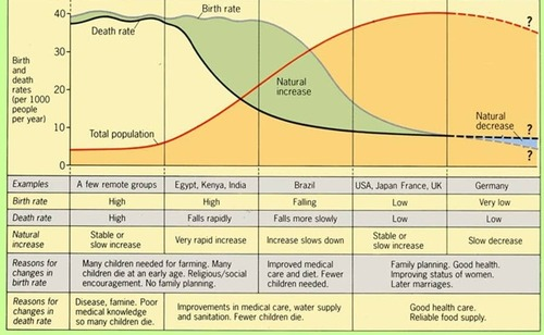
Populations can also increase through migration which can skew data, knowing this is important for analyzing RNI. Doubling time describes how long it would take for the population to double in total. Population dynamics can also be impacted by cultural values, less/more female opportunity less/more babies. Governments can also influence the RNI by impacting antinatalist or pronatalist policies that encourage births. Lastly, economics can boost or deflate births based on economic opportunity for families. The Demographic Transition Model reflects growth and changes in human population through 5 stages of development. This model, however, is based on European society and isn’t always applicable. Similar to the DTM, the Epidemiological transition model shows the development of disease through 5 stages of advancement in society. The ETM is slightly flawed because it doesn’t account for poverty or variations in history or regions suffering from certain diseases. Thomas Malthus believed that the constant increase in life expectancy and growth would mean more food used, so, eventually, the world would fall into widespread famine. Malthus said there should be less children to prevent this. However, technological advancements have proven a solution to this issue.
ETM
Stage one has little to know prevention and humans can die of most anything, the Black Death shows this stage, population grows
Death rate declines because of improved sanitation and medicines to prevent previous disease, but CDR is still high
Birth rate declines and life expectancy increase, causing higher risk of degenerative diseases
Life expectancy is at the highest point because of the most advanced technologies, causing fluctuations in birth/death
Secret 5th stage shows resistances in modern medicines heightening the deadliness of previously cured diseases

DTM
High stationary stage: represents Agrarian and pre-industrial society where birth and death rates are high due to a lack of contraceptives and adequate healthcare. No nations are in stage 1
Early expanding stage: represents early industrial revolution with high births and less deaths because of improved medicines
Late expanding stage: birth and death rates decline because of better education and less of a need for children, but there is still slow population growth
Low stationary stage: Deaths and births even out because of advanced medicines and more concerns on aging-populations
Natural decrease stage: a new stage that has formed because the death rate exceeds the death rate
Importance of population
Population data is important to governments because it allows them to pass certain policies to limit or increase population growth, anti/pronatalist policies. China’s one-child policy shows a good example of antinatalist policies limiting population growth. Pronatalist policies encourage births by making having children cheaper and easier via free daycare, increased leave from work, etc. As an alternative, governments can use immigrants as a population stimulation.
Females’ role
Womens’ status impacts the fertility rate: more opportunity/education = less babies, less opportunity/education = more babies. Family planning and contraceptives can work to limit or control births. However, when womens’ status improves babies that ARE born are more likely to live/reduce infant mortality rates. Ernst Ravenstein developed a set of rules or laws explaining how and why people migrate including women. Ravenstein states that women are more likely to undergo domestic migrations while men are more likely to migrate to another country. For women, their migration is usually rural to urban.
Aging Population
Aging population describes a decreasing dependency that has a lower fertility rate where the middle area of a population pyramid is larger than the bottom. Aging populations can impact political decisions by having a majority vote, more attention will also be paid to aging demographics because they make up more of the population, aging populations can also cause imbalances in economics because social security funds are funded by the working population.
Migration Patterns
Migrants can either emigrate of immigrate, emigrate is leaving immigrate is entering. These processes can occur because something is pushing them out for political, economic, social, or environmental reasons. There are also pull factors that attract migrants for the same reason. Migrants can also face intervening obstacles that prevent them from getting to their destination, especially when your destination is further away. The inverse of this is intervening opportunities when migrants face obstacles that can pull them away from or impact their journey to their final destination, such as a new job. This is largely due to the fact that migrants immigrate in phases and not at once, this is where intervening opportunity can cause you to settle somewhere else. All of these obstacles, pushes, pulls, or opportunity are related to social, cultural, political, environmental, or economic factors. On a deeper level, migration can either be forced or voluntary. Forced migrants can be called refugees if they emigrate to find safety from dangerous conditions. Refugees can seek asylum in foreign countries, but if they stay inside their country they are referred to as internally displaced persons, similar but different. For voluntary migration, there are seven different types:
Transnational migration - migrants move to different countries, but remain in contact or connection with their home through devices or remittances. These migrants can also move in between 2 countries but regardless they are experiencing two cultures.
Transhumance migration - Less common, migrants who move because of their lifestyle, nomadic herders
Internal migration - people who migrate inside of their country
Chain migration - a series of migration that occurred because of someone starting the chain, one after another
Step migration - migration that occurs with barriers or opportunities to prevent one fell swoop
Guest work migration - migrants who are seeking work and move to countries needing guest workers
Rural-to-urban migration - migration that is encouraged by economic activity or any other pull factors related to urban environments
Effects of Migration
Migration can have political impact with fluctuations in population distribution and thus government seats. Disliked or non-native migrants can harass or harm immigrants that are culturally different, possibly causing targeted policies. Countries receiving immigrants can experience economic benefits through increased participation in the workforce. Vice versa, origin countries may experience a lack or freeing of jobs having positive or negative economic effects. Lastly, migrants can send back remittances to boost origin countries’ economy. Culturally, immigrants can bring their culture with them diversifying their new country, but family structures can also be strained.
Unit 3
What is culture
Culture describes shared aspects or traits of a society. Some traits of culture can be easily observed while others cannot. Most observable traits fall into 3 categories: food, architecture on varying scales, and land use. Every culture has unique traits that project certain cultural belief. Cultural relativism is liking your own culture but accepting or appreciating another. Ethnocentrism is the opposite wherein one likes their own culture but to the extent that they dislike or don’t accept others. Xenophobia describes the dislike of foreignerns or foreign cultures/practices.
Use of culture
Culture is imprinted on a cultural landscape that describes how people “show” or practice their culture on the physical land. These is done through:
Agricultural practices - How farming is done can invoke a great sense of place
Industrial practices - Economic activity specific or aligned with an areas history or culture can appear on the cultural landscape.
Religion - Religious architecture distinguishes an areas location based on the religion and the style of architecture
Language - Language spoken or put on signs can act as nod towards the local culture, but it can also be taken a step further in unique areas like Chinatown
Traditional & Postmodern architecture - Different styles of architecture can show values or use of resources on a culture to culture basis. For example, rural or traditional architecture in Latin America vs. fancy, artistic architecture in the United States.
These 4 practices can invoke a sense of place, but they can also make an area feels placeless, where the practices are generic or non-identifying. Also, use of the cultural landscape through multiple generations and cultures can reflect sequent occupancy. Sequent occupancy is an effect that displays multiple cultures through one of the 5 traits above, such as Angkor Watt. The values of culture can also impact the composition of the land. For example, Americans didn’t like Chinese immigrants, so when they settled in the US, they clustered together in ethnic neighborhoods to feel more welcome. Attitudes towards gender can also impact the use of the land such as women in the workforce increasing the number of childcare centers. Partitioning of land to indigenous socities also contributes to alterations in land use.
Cultural Patterns
When we use our cultural practices to make a home we are placemaking. However, the memories and values of what we did on that land is a sense of place. Dialects, religions, and ethnic traits all contribute to our sense of place. These factors bringing people together are centripetal but when they push people apart such as divergencies between dialects, religions, ethnicities, etc. they are centrifugal.
Cultural Diffusion
Cultural Diffusion is the spread of a hearth, the origin, of a culture. Diffusion occurs in multiple ways that have varying effects and processes.
Relocation Diffusion - People move away from the hearth and carry their culture with them
Expansion Diffusion - A broad type of diffusion where traits spread from the hearth, not just/always the people
(Reverse) Hierarchical Diffusion - The spread of traits from developed or socially “higher” areas downwards or the reverse.
Contagious Diffusion - Traits spread and spread amongst people rapidly but without regard to the individuals
Stimulus Diffusion - Cultural traits spread but they are tweaked or adjusted depending on the area they spread to
Cultural patterns can also be spread through imperialism and colonialism. During the waves of European imperialism, traits were spread throughout colonized countries such as French in Algeria or Portuguese in Brazil. These forms of cultural diffusion have had broad effects on different scales. For example, the hybridization or widespread/lingua franca of languages has resulted from the introduction of new cultural traits around the world or in specific regions. Culture and cultural practices are created and used by humans which is key to understand because of the many changes in these practices that occur at both small and large scales. On a small scale, diffusion can impact a single individual or a local community, affecting their practices of foreign cultures. However, large-scale changes have been facilitated through globalization. Globalization is a process that interconnects the world economically, socially, and politically. Not only does globalization increase the amount of connections between cultures but it also forms a reliance on each other. Urbanization has had a similar effect of reliance because many different cultures are packed together in small cities. These urban cities expose cultures to each other but also allow them to undergo diffusion and the creation of new cultural traits. However, this is selective to urban cities. Rural individuals are able to take part in this diffusion through the media, technological changes, global politics, and economics. All four of these processes facilitate diffusion to rural individuals that aren’t in a culturally diverse environment.
Culture unnamed
As more exposure occurs, cultures undergo divergence or convergence, wherein they join together and cultures become more similar to the adoption of traits but the opposite can happen where cultures are exposed to other traits but reject this to practice their own culture. One of the main catalysts for these processes is time-space convergence where time and necessary communication needed for interaction between cultures grows less because of technological developments. However, overexposure can also lead to the diminishment of some cultural traits because cultures become less and less distinct, especially in regard to indigenous languages. Languages are split into categories are split into 3 categories: family, the broadest category containing languages of similar background with some slight similarities but limited understanding, branches, certain languages can somewhat understand each other but not fully, and dialects are subsets of a specific language with clear understanding and only a few differences. Religions are divided into two categories, universalizing and ethnic. Universalizing religions have spread far from their hearth and have values that are applicable to most places in the world, making them a global religion with variations based on where its practiced. Ethnic religions are exclusive to their hearth other than relocation diffusion and have values that are specific to their ethnicity and wouldn’t be universal. The diffusion of religion can be identified on maps or toponyms, the name of a place. Constantinople changing to Istanbul represents the change of a toponyms because of culture.
Universal | Ethnic |
Christianity | Hinduism |
Islam | Judaism |
Buddhism | Shintoism |
Sikhism | Chinese rel. |
Effects of Cultural Diffusion
Cultural diffusion has varying effects that are characterized based on the extent of the effects.
Assimilation - The full conversion of someone to the majority culture, leaving behind many traits of their original culture, both forced and voluntary
Acculturation - Adoption of some traits while also continuing to practice ones own culture
Syncretism - The exposure to two different cultures to create one new culture or cultural trait with distinction from the two
Multiculturalism - Where multiple cultures keep their own traits without adopting any or many traits from other cultures
Unit 4
Political Geography
Political Geography is the arrangement and division of how political power is distributed and how boundaries are drawn. A state is a body of people and land under a single sovereign government. Sovereignty means the power to govern one’s country or self. The nation is a group of people who are united by similar cultural beliefs and practices. A nation-state is a state that consists primarily of one nation. A stateless nation is a group of people who have shared history, beliefs, and distinct cultural traits without their own state, but they are trying to get one. A multi-state nation is a nation that is spread across multiple states but is less independent and may have its own state. Finally, a multinational state is a diverse state that has many nations. Separate from these is an autonomous state that has partial independence within a larger state that has higher power.
Determining Factors of Political Geography
Several factors have greatly impacted the current and future political geography. These are sovereignty, a state’s political power to govern activities within its borders, nation-states, nations that want an independent state like the Kurds, and self-determination, the desire to form a government and have independent rule (rebellion and revolution). Historical processes have also had a significant influence on political geography. Imperialism is the extension of political power across borders into another state. Colonialism has had a similar effect, but more direct because of a direct presence in a colonized country. For example, the European powers’ division of African countries during the colonial period has impacted tensions and borders within Africa today. As a result of this, many countries have undergone independence movements that have divided and created new countries. Lastly, devolution has created or preserved states facing struggles. Devolution is the distribution of power from a central, federal level to individual bodies within a country.
Territory and Political Power
Territoriality is the connection of people to a given area of land. Territoriality leads to the desire and exertion of political power. However, imperialism still exists, which is why territoriality is relevant. The main way of this is neo-colonialism, which is a term used to describe the extortion of economic or political power to control poorer countries forced into an arrangement. This causes an over-reliance of periphery countries on the economic activity of core countries. Territorial power can attract imperialism from core countries that attempt to lay claim to the land. States can also control chokepoints that are essential for economic activity, which can be extorted for economic gain, usually access to trade.
Political Boundaries
Boundaries have features that categorize them: defining, explicit statements of where boundaries begin and end, delimitating, actually drawing and showing a boundary on a map, demarcating, using a physical object to indicated where the boundary is in person, and administrating, government activity to manage the entering and exiting of a boundary. Boundaries are still disputed, though: definitional, disagreement over the written distinguishing of a boundary, locational, physical boundaries that move over time, transitional, operational, conflict over the functioning of the administrative feature of a border, and allocation, disagreement when natural or valuable resources are divided or blocked by a border. Treaties can also form Demilitarized zones that can’t have any borders. Policy agreements are where conferences or meetings are held to agree on the formation of borders that benefit those delimiting them. Sea boundaries have different regulations. All countries on the seas have 12 nautical miles around their border. In addition to this, countries have exclusive economic zones spanning 200 miles off their coast where they have access to economic activities such as trade and the collection of natural resources. Disputes over EEZs are settled by the United Nations Convention on the Law of the Sea (UNCLOS).
Types of Political Boundaries
There are types of boundaries characterized by the features listed above: antecedent boundaries, boundaries formed before settlement, subsequent boundaries made after people have settled an area and given it some form of cultural landscape, consequent boundaries, decided based on regional cultural and ethnic composition and landscape, superimposed, boundaries made by foreign and higher powers without regard to local cultural landscapes, geometric, boundaries based on a mathematical shape or degree, usually straight, and relic, a former boundary that is no longer in use by still has historical significance or current influence.
Internal Boundaries
Boundaries within a country can influence political processes such as redistricting. Redistricting, namely in the US, is determined based on a census whose data is used to help decide upon equal boundaries. However, redistricting isn’t always fair because of gerrymandering. The majority party in the US draws boundaries to benefit their party. Government is also organized based on two types of governance. Unitary where there is one central authority that has sole governance over local states that have some governance under the authority of the central body. This system is more efficient at applying policies across the country, but they don’t always reflect the whole population’s ideology. The other system is a federal state with one central authority that has national influence but also distributes power to local levels. This is helpful in better reflecting each individual’s opinions. Contradictory policies can be passed that differentiate local and federal legislation. In addition to this, the federal government can face struggles with efficiency because it doesn’t have absolute or great power.
Devolution: Causes and Effects
Devolution can occur because of physical barriers preventing collaboration from central areas. Ethnic separatism can cause internal conflict because of rivaling ethnicities within a country. Ethnic cleansing is similar but more violent, which facilitates self-determination. Terrorism is a form of protest against the federal government in the desire for sovereignty. Conflicts in economic activity can cause federal involvement, which may not always be favorable for locals. Social preferences can cause slowing in government because of opposing ideologies. Irridentism is when a country has citizens who affiliate with a foreign state and want to convert their original country’s land to the country they identify with. Devolution can have significant political, economic, and social results. Autonomous regions that have almost complete self-governance within a larger political entity can be formed. Subnational political units can form with new political structures to accommodate social or economic preferences. There are a few essential examples: Canada giving more power to Quebec to aapease French speakers who have distinct social differnecs from the rest of Canada, Belgium giving separate legislatures to Walloons and Flanders with separate economic activities, Spain supporting various autonomous units to prevent desires of self-governance and promote democracy, and Nigeria who was split to 3 ethnics groups that caused the devolution of power into 36 states. Balkanization is a form of devolution where ethnic conflicts get so extreme that a single state splits up.
Supranationalism
Technological developments also challenge sovereignty because of improved communication and the organization of rebellions. Another challenging factor is supranationalism, wherein states give up some power to participate in supranational organizations. Supranationalism has become more relevant due to environmental concerns requiring global support and involvement. Supranational organizations can also provide countries with various economic benefits through a single economy. Similarly, trade organizations can be formed to reduce trade barriers for economic growth. Lastly, military alliances provide security for member states through collective involvement. These supranational organizations are big because they are giving up sovereignty, but also creating a system of international politics and global connections.
Centrifugal and Centripetal Forces
Centrifugal forces can cause a failed state wherein states aren’t able to cover or manage basic necessities. This government is now completely diminished or uninvolved. Centrifugal forces can also cause extreme gaps in development across a state. Centripetal forces can unite ethnically similar individuals, causing a sense of pride for one’s ethnicity. Better internal development can bring citizens together by establishing a sense of nationalism. Cultural cohesion can promote pride for a country, thereby uniting its people.
Unit 5
What is Agriculture
Agriculture, by definition, is the growing and raising of domesticated plants and animals. Physical and environmental conditions, the soil and topography, as well as the arrangement of landscapes like mountains and rivers, are important for the effectiveness of growing crops. The climate is the pattern of weather throughout time; climate affects the type of crops you can grow. Tropical climate is good overall because of warm temperatures and a lot of precipitation. The Mediterranean climate is also good for farming, with clear skies, precipitation, and mild winters. However, agricultural practices in these climates and around the world vary.
Types of Agriculture/Farming
Intensive farming uses a lot of labor and resources to maximize the yield: market gardening, small scale with high quality, and for a close market, plantation agriculture, requires lots of resources and high-quality products to sell on a large-scale at a distant market, and mixed crop/livestock, uses grown grain to feed livestock who’s fertilizer (poop) is put back into the crops. All intensive agriculture is for market and profit, not personal use. Extensive farming uses less-expensive products for farming lower yields: shifting cultivation, using plots of land before they are existed and repeating the process through slash-burn reuse, nomadic herding, raising livestock across a large amount of land and living “on-the-go” in areas unfit for crops, and ranching, using large spaces of land to grow livestock, sold for their hide/wool/meat in areas unsuitable for crops.
Origins of Agriculture and Development
Farming originated from the first agricultural revolution in Mesopotamia (Fertile Crescent), the Nile River, the Indus River Valley (India), South East Asia, and Central America. This development allowed them to settle in a single area, leading to civilizations, leading to increased interaction and technology, spreading their new knowledge. This exchange was the diffusion of farming techniques between Europe and the Americas, the Columbian Exchange. Indigenous peoples’ diets improved, and they could hunt better with the horse. Europe received maize and potatoes, improving their nutrition. The Second Agricultural Revolution spread from Europe. This changed the organization of farmland and led to rural to urban migrations because wealthy landowners privatized, known as the Enclosure Movement. This revolution also spawned many technological developments that increased yields through efficiency, such as the seed drill and the mechanical reaper. Variations in food also improved diets, causing a population boom. The Green Revolution used cross-breeding, chemicals/pesticides, and increased mechanization on a global scale to solve a global food shortage. However, the Green Revolution worsened the environmental quality of land used in farming, and the lack of female involvement in many of the developing countries benefited from the Green Revolution. Also, the Green Revolution led to the monopolization of seeds and farming resources, causing many farmers to be unable to afford modern technologies.
Spatial Organization of Agriculture
Farming settlements impact yield and the surrounding society. Most of the time, farm settlements are clustered to share access to services like schooling and easier access to trade among citizens. However, some farm settlements are dispersed and disconnected, like in the Midwest. Similarly, there are linear settlements, usually along a road or river, for access to farming resources or transportation. The spatial pattern of farm settlements comes in three forms: metes and bounds, based on the physical landscape, and in oblong, clustered shapes, township and range, even square plots clustered into pacts, and long lot settlements, a series of rectangular plots dividing settlements into linear patterns.
Purpose of Agriculture
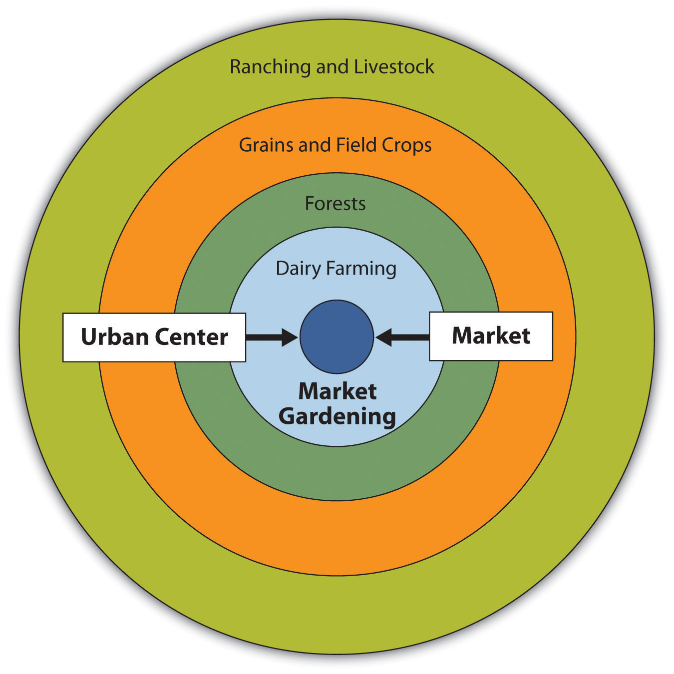
Subsistence agriculture is a method used for a family's diet or a local community. Commercial agriculture is used solely for economic profit; this form is usually through monocropping, a single crop grown for sale. Subsistence agriculture is in developing countries, whereas commercial agriculture is in developed countries. Both forms of farming can be categorized as intensive or extensive. The land used for farming conforms to bid-rent theory, land value decreases the further it is from the market, which is important in determining what category of intensive or extensive it falls into. Intensive market gardening is closer to CBD because of the proximity required by perishability vs. extensive farming, that have less perishable items that can be produced further away. This CBD theory was made by Von Thunen’s model, which predicts the type of agriculture based on distance from the CBD.
Von Thunen
Center dot is CBD
Dairy Farming has the highest perishability, so it requires close proximity.
Timber/forestry is next because wood is heavy, so being close makes transport cheaper.
Barley is next out because it isn’t as perishable or expensive to transport.
Ranching and livestock need the largest amount of land, so they are all the way out.
However, Von Thunen is a little outdated because there are multiple markets that are subject to outside influence. Also, his model doesn’t account for transport through physical barriers in modern vehicles. Lastly, certain farming conditions require special land use.
Economics in Agriculture
Large-scale corporations called agribusinesses that focus on monocropping are replacing traditional family farms. Most are family farms, but they only make up 20% of the product produced. They are maximizing efficiency for profit. Economics has also influenced agriculture through complex commodity chains that are the various processes to get a product to its final destination. Along this chain, it gains value in each step, allowing agribusiness to dominate the chain also known as vertical integration. The overall economic benefit and increased product manufacturing is called the economies of scale. Technology has impacted agriculture by pushing the limits of mass production with fewer resources.
Global/Modern Agriculture
Countries have become more dependent upon each other for food, demand in some places, and supply in others. This dependency is called the global commodity chain, but this has caused concerns with the ethical production of certain products. While international trade and exchange can benefit developing countries, these countries also have to focus on a monocrop, export economy, relying on the demand of importing countries. Global supply chains can be impacted by political relationships such as trade wars, infrastructure, or lack thereof, preventing them from getting involved, and patterns in trade, such as alterations to ethical working conditions.
Effects of Agriculture
Commercializing global agriculture can threaten the environmental quality of farms using chemicals/pesticides, overworking of the land (deforestation), runoff, increased pollution, and salinization. Non-natural farm land in arid areas uses irrigated water, evaporating the water and creating a layer of salt. In response, political bodies have developed policies to combat poor land treatment. Socially, diets have changed because consumers can access a wider variety of food. Women have had less of a role in farming because of its mechanization. Monocropping can be suitable for profit but alterations in demand could cripple the economy. Shifting cultivation is using all the resources of a plot of land and then rotating to another plot. The old plots are rejuvenated through slash-and-burn techniques to fertilize the soil naturally. Terrace farming alters the landscape for sustainable agriculture in the natural landscape. Irrigation is a farming technique that directs farms by rain, dams, or aquifers. This is good for previously unusable land but only in a certain degree. Draining wetlands was used as irrigation, but it was found that wetlands were key to the climate, and were used for arable land. Pastoral nomadism used to be sustainable, but has caused overgrazing and land degradation.
Contemporary Agriculture
Biotech in improving farming has grown controversial because, although it produces more of a better product, it can harm the environment and our diet, namely, aquaculture and GMOs. Individuals can disrupt agriculture through urban farming, growing crops on small plots in metropolitan areas with limited access to healthy foods, consumer supported agriculture (CSA), consumers enter into an agreement with farmers for a share of their product disregarding the global supply chain, organic farming, the use of natural and safe practices to grow products for higher costs, value-added special products, raw products refined into higher-value items, fair trade products, consumers pay more knowing workers are paid and treated fairly, local food movements, growing and purchasing products locally to support smaller famers, and dietary shifts, on varying scales that affect supply and demand.
Challenges with Food Distribution
The food supply is skewed, causing food waste in developed countries and food insecurity in developing countries. People without food don’t have transportation or infrastructure to distribute food to those in need. Certain areas with harsh weather can cause crop losses and serious consequences on the community’s food supply. Suburbanization decreases the amount of land available for farming. The location of food processing facilities impacts the destination of many foodstuffs. Developed countries are the primary holders of these facilities, meaning they receive more food imports than developing countries, whose products can be lost without proper infrastructure. Similarly, there isn’t enough storage globally, and what storage there is is usually in developed countries. Lastly, the government can encourage farmers to grow certain crops for economic activity through subsidies and funding.
Womens’ role
In developing countries, women are excluded from learning agricultural practices and owning land that could be used to practice farming. This has excluded them from farming in developing countries. However, in developed countries, farming has become mechanized, limiting women’s opportunities for involvement. The other reason women don’t participate in farming is that the monopolization of the industry has opened opportunities for management or corporate positions, pulling them away.
Unit 6
Origin and Influence of Cities
Site is the physical location where a city is built, and the landscape features. Situation is how sites are connected to each other, and the relative location based on their surroundings. These determine where a city is built. Situation is used to determine the current functions of cities. Urbanization is based on several factors:
Development of transportation within a city, drawing people in
Access to communication technologies is increasing productivity and connectedness,
Population growth from births and migrations, attracting job opportunities,
Economic development has made cities powerhouses of production and activity,
Government policies have also had an impact on land use in cities, including the infrastructure supporting functions
Urbanization, specifically population growth, has led to mega and metacities with populations of 10,000,000 (mega) and 20,000,000 (meta). Urbanization has also had an impact on the surrounding area: suburbanization, the development of the surrounding areas made for residential purposes outside of urban areas, sprawl, the spreading of urban areas and their effects outwards. Urbanization has caused disconnected suburban communities and traffic congestion.
Landforms
Land forms and use have created new developments in housing and economic activity. Edge cities are communities separate from a major urban area that receive economic and political benefits from their proximity, usually assisted through transportation. Exurbs are outside of suburbs that have connections to the city but are further out. They are the suburbs of the suburbs with more abundant land usually inhabited by wealthier folk. Boomburbs are suburbs that have experienced extreme growth and have over 100,000 residents. Boomburbs are sometimes accidental cities because they are practically cities themselves.
Cities in Globalization
Cities aren’t isolated; they are a part of a global hierarchy. The top of the hierarchy is world cities with heavy social, political, and economic influence on other cities and civilizations worldwide. World cities form through globalization, but they also increase globalization throughout the whole world. Their influence controls different economies, governments, and other bodies. The rank-size rule is a measurement that says that the 2nd largest city is half the biggest, the 3rd largest city is 1/3 of the biggest city, etc. This rule sometimes works, but is limited. The primate rule says that the largest city will have a population much higher than any other city in a country. Christaller’s central place theory describes the arrangement of businesses and settlements in relation to a central point. It is made up of hexagons based on threshold, the amount of consumers needed to support a good/service, and range, the maximum distance consumers are willing to drive for a product. Low-order products are high frequency, high threshold, low range, and common in small settlements. High-order products are low frequency, low threshold, high range, and usually found in large cities. This is based on the gravity model that describes the interactions between cities and their impact, extent, and frequency. Gravity increases with the influence and size of cities, influence/size matters more than distance.
Modern settlement patterns
Land closer to the CBD has more economic activity with a higher population density the closer you get. Zoning ordinances are created to determine the use of land. Land use reflects historical purpose and division, technological capabilities, transportation can show differences in demographic settlement, cycles of development, and infilling is improving useless land for residential housing. Infrastructure is important for providing necessary functions within a city and is a good reflection of its development. Infrastructure can also attract economic and political activity from businesses and government bodies. Urbanization and modern cities require sustainability policies. Smart-growth policies aim to prevent sprawl and protect the environment through improved walkability, public transport, and mixed-use housing. New Urbanism focuses on smart transportation, dense populations, and more local smart-growth policies. Greenbelts promote sustainability by preventing sprawl, “greening” congested cities, and protecting the environment. Slow-growth cities build dense buildings to pack people into cities and convert agricultural land to residential land to prevent sprawl. While some support these developments, others dislike their lack of effort, increased housing costs, loss of history and sense of place, increased population density, and segregation for those who can’t afford it.
Implementation of city development
Data is used by the government to decide what kind of developments need to be made in cities. Quantitative and qualitative data are needed to make these decisions and check each other. Problems arise with these modern developments, namely redlining, using districting to prevent poorer people from gaining the same opportunities as others, blockbusting, evicting richer folk by making them believe that black people are moving in, and housing affordability, disparity in costs preventing poorer folk from affording certain homes and neighborhoods. Governments can influence the rent in certain cities and zones. Citizens of lower socioeconomic status face worse conditions. They also struggle with disamenity zones and zones of abandonment, which have no basic amenities or are uninhabited. The poor have created squatter settlements that have no amenities and are made of abandoned buildings. Governments aren’t always able to control urban areas and must fragment or distribute power to address these issues. Their responses include inclusioning zones that mandate mixed-housing development, which is controversial because those targeted by these may be unable to afford the local supplies. Urban renewal initiatives aim to improve run-down zones that displaced some residents. Similarly, gentrification redevelops areas that force poorer folk out.
Urban Sustainability
Suburban sprawl is caused by cities requiring more resources, worsening the environment because they take up space or need to disperse waste. Cities greatly contribute to global warming through high heat, building materials, and CO2 production. Sanitation quality is also reduced the more urbanized a city is. Pollution from cities also reduces air and water quality. Cities and regions work together to solve these challenges through resource allocation and increased cohesion. Brownfields are abandoned sites that are improved to remove pollutants and repurposed for previously useless land. Urban developments such as greenbelts and green spaces are used to reduce expansion at the cost of land. Policy can also be used to protect green land and prevent further urban development.
The Seven Urban Models
US Models
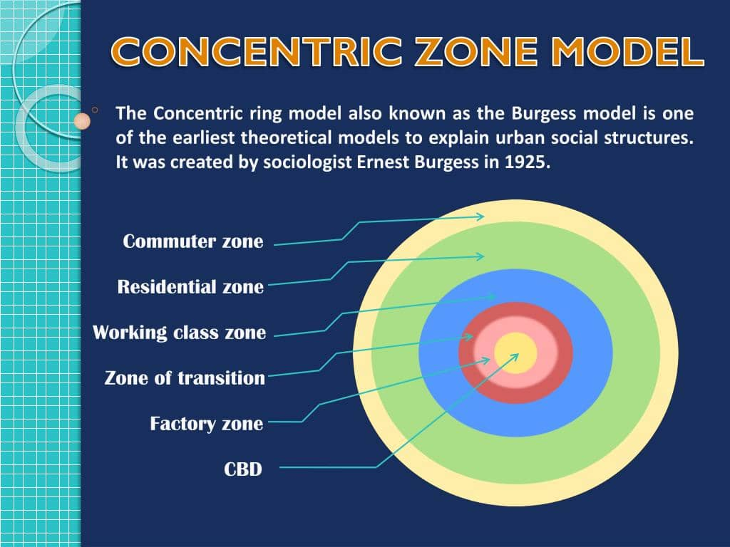
The Burgess Concentric Zone Model, which says that cities expand outwards from the CBD. It has businesses and major institutions in the Middle, the Factory and industrial institutions, mixed land use, and the poorest residents, then working-class residential in industrial areas, middle-class residential with less density, and upper-class residential with generous transportation to support further settlers. It is very theoretical and not realistic, and only considers distance from CBD.
Added direction in addition to distance. It used wedges to reflect transportation, especially trains and electric vehicles. Similar to Burgess with poorer closer to center and richer further with transportation

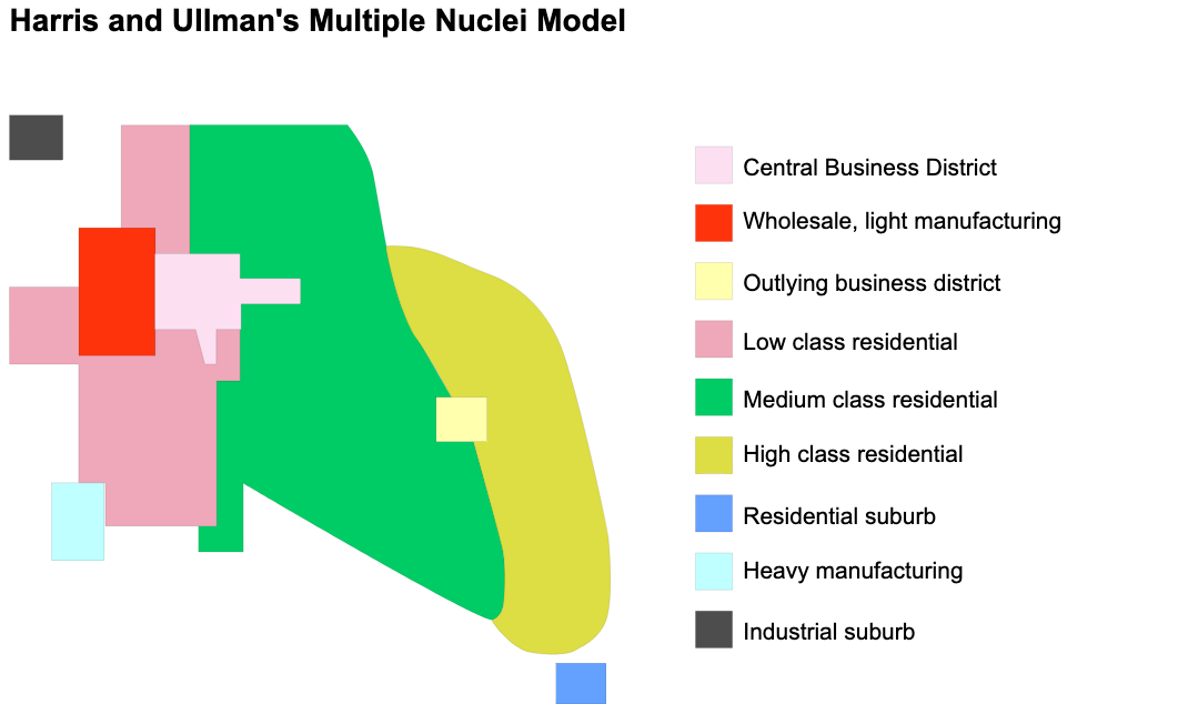
This countered previous two by having multiple nuclei or major locations with acknowledgement to transportation. Functions grew beyond CBD and had multiple primary areas. It didn’t account for the blended nuclei that reduced distinction.
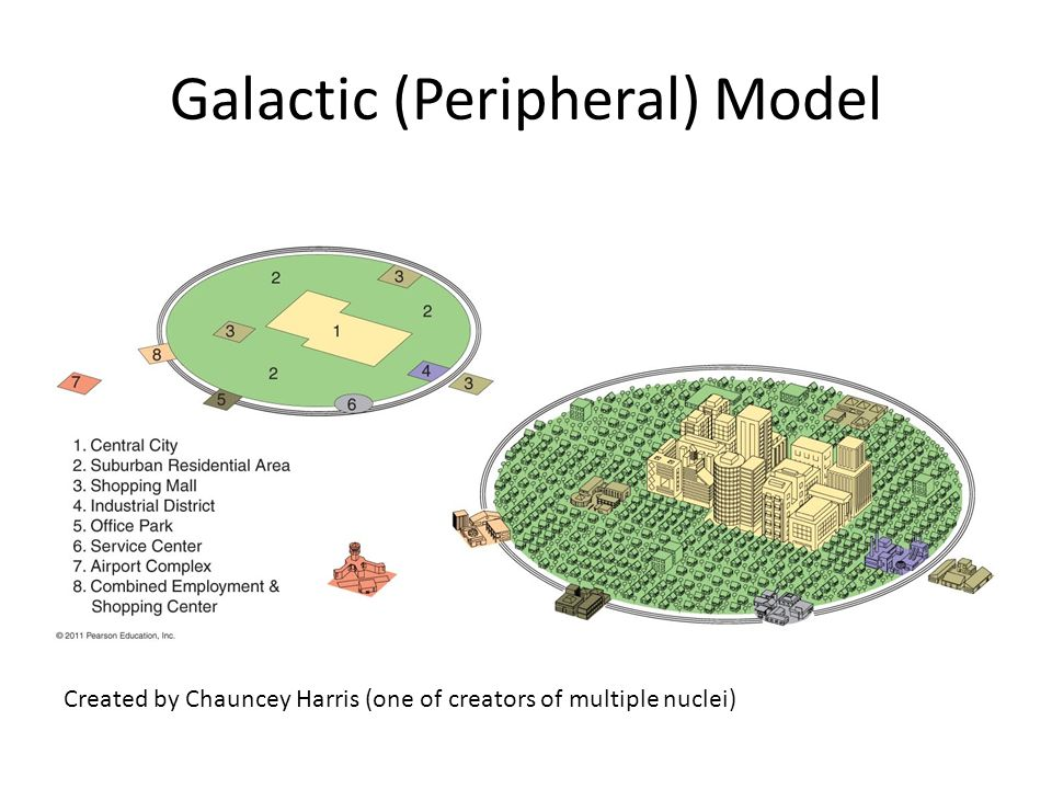
Created to represent developments in urbanization and the common use of cars. CBD influence is decentralized, and goods and services vary based on transportation, which connects multiple sectors. Suburbs and CBD have equal employment. However, this model didn’t account for digital shopping and work that reduced the impact of transportation networks.
Other parts of the World
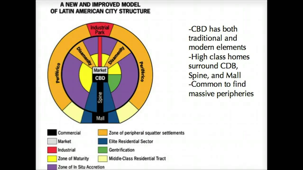
Used to explain Latin America, specifically previous colonies. CBD is influenced by Spanish law and has market. The spine has quality transport with upper-class residents on either side. Inner-purple has poorer individuals. Lastly, the outer edges are squatter settlements with little to no amenities.
Also influenced by colonialism and isn’t focused on CBD but on maritime trading ports. High-class zones are closer to the ports are govt. zones. Mixed/suburbs are mixed with squatter settlements. This model is the only one that has a market gardening zone.

The African Model has 3 CBDs, colonial, traditional market, and modern CBD. Neighboorhoods with unique ethnic traits surround the various CBDs with individual industries. On the very edges are squatter settlements with transportation running throughout.
Unit 7
Industrial Revolution
Agrarian transformed to industrial through mechanization, creating the condition for the modern economy. It impacted industrial societies by increasing the food supply, population growth, migration and urbanization, and hierarchical structures. People started identifying more and more with people of similar hierarchical status. Industrialization also led to increased colonialism because of increased labor, resource demand, and the need for new markets.
Economic Patterns
Economic sectors have developed with increased commercialization:
Primary - extraction of natural resources
Secondary - refining and manufacturing resources
Tertiary - services based on products or knowledge
Quaternary - Tertiary sectors with services but requiring more expertise
Quinary - Tertiary sector with services of the highest expertise with the highest impact
Least-cost theory suggests that factory locations are based won here it would be the cheapest. Transportation costs are the biggest factor in determining where to locate. Whether a product would be located closer or farther from the market, if it gains weight through production, it’s closer. Webber’s model is interested in manufacturing, while Von Thunen’s model was focused on agriculture. Webber’s main limitation was theory, not reality. Facotries have other important factors like energy, special materials, break-of-bulk points, areas where bulk goods are transferred from one mode of transportation to another, and access to transportation. Economic development has caused a hierarchy in countries involvement in global trade and activity; core, semi-periphery, and periphery. Some countries have expanded out of their hierarchical role.
Measures of Economic Development
Development is measured in money as well as education, healthcare, etc. Gross national product measures the total value of citizens’ output of goods and services across the whole world. Gross Domestic Product measures the total value of citizens’ output of goods and services within a country's borders, including services from other countries occurring within a country. Gross National Income is the total money earned by businesses, similar to GNP but with income earned through economic activity. These can be measured per person/per capita, dividing the total number by the population. This helps calculate the even spread and actual level of total development. Formal sectors are regulated and registered under law, but informal sectors are not factored or registered by law, causing inaccuracy in the calculation of income in peripheral countries.
Measures of Social Development
There are also measures of development based on social factors. The Human Development Index is a measure of economic human well-being, such as education and healthcare. The Gender Inequality Index focuses on women’s role in society based on the maternal mortality rate and adolescent birth rate. Lastly, labor market participation is used as a ratio of women to men in the workforce. Gaps between the rich and the poor are also used to measure disparity in social development. Lastly, fertility rate can show development because educated women have fewer children. Equality between men and women is called gender parity. Women’s work includes raising children, teaching school, secretarial work, etc. Even when women take on men’s jobs, they face the wage gap. Microlending is a way to help impoverished women by giving them economic opportunity, changing whole societies.
Theories of Development
Rostow’s theory of economic development states that every country begins at stage one, leading up to the final stage five of development. Assumes every economy develops in isolation and will experience no obstacles in development. Wallerstein’s theory says that distribution is uneven based on core and (semi-) periphery. Core countries are dominant because they developed earlier. Despite colonialism, they have surpassed these impediments and become semi-peripheral countries. Dependency theory says that periphery countries are poor because the global economic system forces them into their position. Also, periphery countries rely on commodity exports which greatly influence their effects.
Trade and the World Economy
Complementarity is that some countries have things that other countries need. Comparative advantage is that countries specialize in certain goods which gives them an advantage. Neoliberal policies support free trade and connectedness. This has also been done through trade organizations like EU and WTO. This includes trade wars exchanged political exertion. International crises can occur because global economics are super connected. Fordism is mass production and consumption of goods; this attracted investments in poorer countries.