Chapter 13 – The Ocean Floor: Comprehensive Bullet-Point Notes
13.1 The Vast World Ocean
Earth as the “Blue/Water Planet”
\approx71\% of Earth’s surface (\approx360\text{ million km}^2) is covered by the ocean.
Remaining \approx29\% (\approx150\text{ million km}^2) is continental & island landmass.
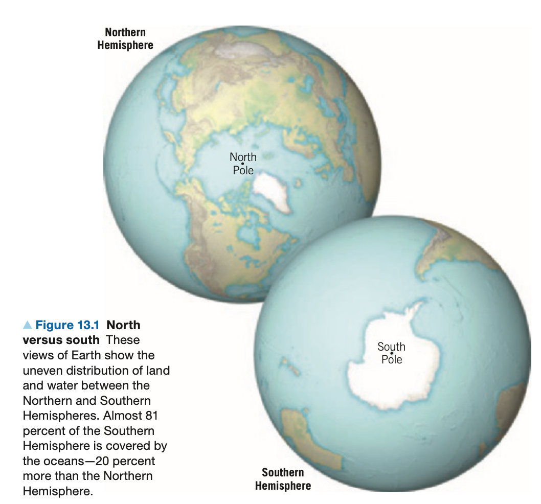
Disproportionate land–water distribution:
Northern Hemisphere = Land Hemisphere: 61\% water vs. 39\% land.
Southern Hemisphere = Water Hemisphere: 81\% water vs. 19\% land.
Four Principal Ocean Basins
Pacific Ocean: Largest geographical feature on the planet
occupies > 1/3 of total surface, > 1/2 of oceanic area.
Average depth \approx3940\text{ m} \,(\sim2.5\text{ mi}); could hold all continents with space left.
Atlantic Ocean:\approx1/2 the area of the Pacific; slightly shallower
bounded by near-parallel continental margins → comparatively narrow.
Indian Ocean: Slightly smaller than the Atlantic; comparable depth; largely a Southern-Hemisphere basin.
Arctic Ocean
Smallest ( \approx7\% of Pacific’s size )
shallowest ( \approx1/4 average depth of other oceans ).
Southern / Antarctic Ocean (informal)
Waters south of 50^\circ S where Antarctic currents converge; composed of southern portions of Pacific, Atlantic & Indian.
Oceans vs Continents
Mean continental elevation \approx840\text{ m} above sea level.
Mean ocean depth \approx3729\text{ m} → oceans are \sim4.5× deeper than continents are high.
Hypothetical perfectly smooth Earth would be submerged by >2000\text{ m} of seawater.
13.2 An Emerging Picture of the Ocean Floor
Bathymetry
Definition: measurement & mapping of ocean depths/topography (bathos = depth, metry = measure).
Historic Beginnings – HMS Challenger (1872-1876)
First global survey; 127,500-km voyage; hand-line soundings recorded deepest point (later named Challenger Deep).
Modern Mapping Technologies
Echo Sounder / Single-beam Sonar
Emits acoustic "ping"; depth = \tfrac12(1500\,\text{m s}^{-1}\times\text{travel-time})
Sidescan Sonar
Tow-fish produces fan-shaped swath images; good for texture but originally lacked accurate depth.
Multibeam Sonar
Hull-mounted array; obtains tens-km-wide depth swaths; cm–m vertical resolution; vessels "mow the lawn" at \sim10$–$20\,\text{km h}^{-1}.
Only \sim5\% of seafloor mapped at high resolution—entire mapping would require >100 ships for centuries.
Satellite Radar Altimetry
Measures sea-surface height anomalies (cm-scale) caused by gravitational attraction of sub-seafloor masses; converts to bathymetric maps.
Key discovery: ocean surface mimics hidden topography (ridges → bulges; trenches → depressions).
Three Major Physiographic Provinces
Continental Margins
Deep-Ocean Basins
Oceanic (Mid-Ocean) Ridges
13.3 Continental Margins
Passive Continental Margins (Atlantic-type)
Tectonically inactive; far from plate boundaries; develop after continental rifting → seafloor spreading.
Broad sediment-rich shelves, slopes & rises.
Continental Shelf
Submerged extension of continent; avg. slope \approx0.1^{\circ}; width from <1 km to >1500 km.
Economically valuable: petroleum reservoirs, fisheries.
Shelf Break: abrupt change to steeper slope.
Continental Slope
Avg. slope \approx5^{\circ} (locally >25^{\circ}); marks transition to oceanic crust.
Continental Rise
Wedge of merged deep-sea fans at base of slope; built by turbidity currents.
Submarine Canyons
Deep valleys incising shelf & slope; carved mainly by episodic turbidity currents (dense, sediment-laden flows); extend beyond rise.
Produce graded-bedded turbidites.
Active Continental Margins (Pacific-type)
Coincident with convergent boundaries (subduction zones) or transform systems; characterized by:
Narrow shelf, steep slope, offshore deep-ocean trench.
Accretionary Wedge: sediments scraped from subducting plate plastered against overriding plate (common in low-angle subduction).
Subduction Erosion: opposite process—sediment & rock peeled from overriding plate, carried downward (steep-angle zones).
Associated phenomena: strong earthquakes, continental volcanic arcs or volcanic island arcs.
13.4 Features of Deep-Ocean Basins
Deep-Ocean Trenches
Long, narrow depressions—the deepest parts of oceans; sites of descending slabs.
Examples: Mariana Trench (Challenger Deep \approx10{,}994\text{ m}), Peru-Chile, Aleutian, Tonga.
Parallel volcanic arcs: island arcs (ocean-ocean) or continental arcs (ocean-continent).
Abyssal Plains
Flattest places on Earth; relief < 3\text{ m} over >1000\text{ km} (
e.g., Argentine Basin).Formed when irregular oceanic crust is buried by thick (>1\text{ km}) blankets of fine terrigenous, biogenous & hydrogenous sediment.
More extensive in Atlantic (few trenches to intercept sediment) than Pacific.
Volcanic Structures
Seamounts: submarine volcanoes; >1\times10^{6} estimated; may form linear chains (e.g., Hawaiian-Emperor).
Volcanic Islands: seamounts that breach sea level (e.g., Tahiti, Galápagos).
Guyots: flat-topped, submerged volcanoes—eroded former islands that subsided with plate motion.
Oceanic Plateaus: massive, thick accumulations of flood basalts from mantle-plume heads (e.g., Ontong Java, Kerguelen); >30\text{ km} thick.
13.5 The Oceanic Ridge System
Global Morphology
World-encircling, >70{,}000\text{ km} long, 2$–$3\text{ km} high swell; width 1000$–$4000\text{ km}.
Segmented (offset by transform faults) & named: Mid-Atlantic Ridge, East Pacific Rise, Mid-Indian Ridge, etc.
Rift Valleys
Deep, fault-bounded troughs (30–50 km wide; walls up to 2500\text{ m} high) along some ridge axes → sites of crustal stretching & magma injection.
Elevated Topography – Thermal Buoyancy
Newly formed lithosphere is hot & less dense; as it moves away it cools, contracts & subsides.
Thickness of oceanic lithosphere increases with age, stabilizing at \sim80$–$100\text{ km} after \sim80 Myr.
Processes & Heat Flow
High heat flow, frequent basaltic volcanism, abundant normal/strike-slip faulting, hydrothermal circulation (black smokers → metal sulfides).
13.6 Seafloor Sediments
Three Genetic Categories
Terrigenous (land-derived): mineral grains weathered from continents; delivered by rivers, wind, glaciers, turbidity currents.
Blanket entire ocean but thin (
abyssal clay accumulation rate \sim1\text{ cm}/10{,}000\text{ yr}).Biogenous (organism-derived): shells/skeletons of planktonic organisms.
Calcareous ooze (CaCO_3) from foraminifera, coccolithophores; dissolves below CCD \sim4500\text{ m}.
Siliceous ooze (SiO_2) from diatoms, radiolarians.
Phosphatic remains from fish bones/teeth.
Hydrogenous (precipitated from seawater):
Manganese nodules: concentric layers of Mn, Fe + Cu, Ni, Co.
Calcium carbonates: direct precipitates in warm, shallow seas → oolitic limestone.
Metal sulfides: precipitated around hydrothermal vents; rich in Fe, Cu, Zn, Ag, Au.
Evaporites: halite (NaCl), gypsum, anhydrite from restricted basins with high evaporation.
Sediments as Climate Archives
Micro-fossil assemblages & isotopic composition reflect surface-water conditions → reconstruct temperature, ice volume, productivity.
Drill cores (e.g., JOIDES/Chikyu/IODP) provide multi-Myr records – crucial for Quaternary Ice-Age studies.
13.7 Resources from the Seafloor
Energy Resources (>$95\%$ of economic value)
Oil & Natural Gas
Origin: buried marine microorganisms in sedimentary basins on continental margins.
Offshore now provides >30\% of global oil; major provinces: Persian Gulf, Gulf of Mexico, North Sea, Brazil, West Africa.
Environmental risks: spills, blowouts (e.g., Deepwater Horizon 2010).
Gas Hydrates
Ice-like clathrates of water + mainly methane; stable beneath >525\text{ m} water or permafrost.
Global volume est. \sim20 quadrillion \text{m}^3 ((\sim2\times) carbon of all other fossil fuels).
Challenges: dissociate at surface P–T; extraction & seafloor stability.
Non-energy Mineral Resources
Sand & Gravel
Used in construction, land reclamation, beach nourishment; second only to petroleum in marine value.
May host placer deposits (gold, tin, titanium, diamonds).
Evaporative Salts
\sim30\% of world’s NaCl from seawater (solar ponds); also Mg, bromine.
Manganese Nodules & CoCrNi-rich Crusts
Potential source of strategic metals; technological & legal hurdles (UNCLOS mining codes) + environmental concerns.
Integrative Connections & Broader Significance
Plate-Tectonic Context
Continental margins, trenches & ridges are surface expressions of divergent, convergent & transform boundaries.
Processes operating underwater mirror those shaping continents (rift valleys vs. East African Rift; volcanic arcs vs. Andes).
Climate–Ocean Feedbacks
Distribution of land & water influences atmospheric circulation; Southern Ocean’s uninterrupted westerlies affect global heat balance.
Sedimentary records supply long-term context for modern climate change debates.
Biosphere Interactions
Hydrothermal vents support chemosynthetic ecosystems independent of sunlight → origin-of-life implications.
Coral-reef development (Darwin’s atoll model) illustrates interplay of volcanism, plate motion & biology.
Human & Ethical Dimensions
Resource extraction vs. environmental stewardship (oil spills, nodule mining, gas-hydrate destabilization).
Mapping & understanding oceans underpin hazard mitigation (tsunamis, submarine landslides) & conservation (marine protected areas).