ch 13 the earth's oceans
expeditions:
hms challenger expedition - 1872-1876
measured deepest point in ocean
the vast world ocean:
71% of earth’s surface is oceans/seas
29% is continents and island
northern hemisphere - land
southern hemisphere - water
4 main ocean basins:
pacific - largest w/ greatest depth
atlantic - ½ size of pacific, less deep
indian: slightly smaller than atlantic, mainly southern hemisphere
artic: 7% size of pacific
bathymetry - measurment of ocean depth and charting shape or topography
echo sounder (sonar)
side-scan sonar - towed behind a ship
multi-beam sonar
satellite alimeter (from space)
3 topographic units of ocean floor:
continental margins
ocean basin floor
mid-ocean ridge
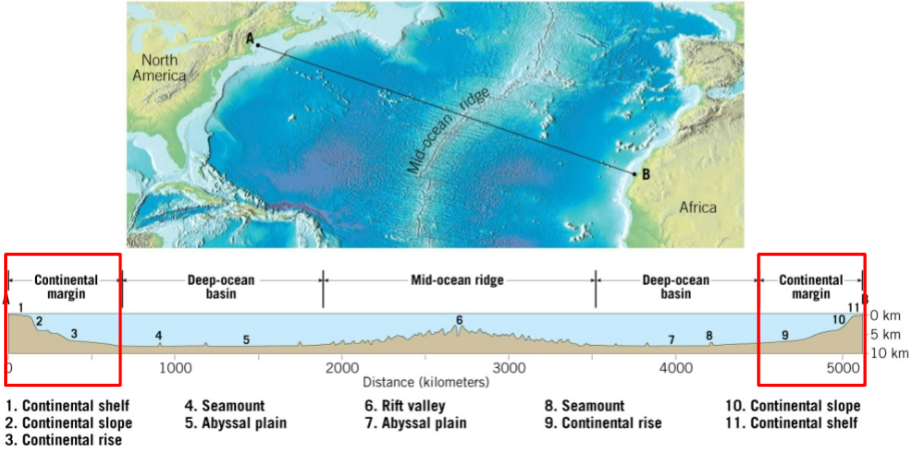
continental margins:
passive - found along coastal areas surrounding atlantic
not associated w/ plate boundaries. they experience little volcanism and earthquakes.
continental shelf - flooded extension of continent with <1 degree slope, contains oil and important mineral, thick accumulations of shallow-water sediments
continental slope - seaward edge of continental shelf, slope between 5-25 degrees, boundary b/w continental and oceanic crust
continental rise - gradual incline that might extend 100’s of km, found where there’s no trenches, thick accumulation of sediment, deep-sea fan
active - continental slop desends abruptly into deep-ocean trench, usually in pacific, subduction zones don’t have sediments, accumulations of deformed sediment of ocean crust form accretionary wedges
deep ocean trenches - long, narrow, deepest parts of ocean, most in pacific, sites where moving lithosphereic plates plunge into mantle, associated wiht volcanic activitiy, volcanic island arcs and continental volcanic arcs
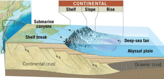
turbidiy currents: downslope movements of dense, sediment filled water. created when sand and mud on continental shelf or slope are dislodged and thrown into suspention. bc muddy water is denser than seawater, it flows down and, eroding and accumulating more sediment
ocean basin floor:
abyssal plains
most level place on earth
all oceans
sites of thick accumulations of sediment. fine sediments from land, precipitated minerals, shells/skeletons of marine organisms
seamounts and guyots
erupt as volcanic island then cool off/solidify
caused them to sink and we call them flat topped guyots
become flat from wave action
mid-ocean ridge:
elevated positions, extensive faulting, and volcanic structers that have developed on newly formed crust
longest topographic feature on earth’s surface
70+km / /43k miles in lengh
23% of earth’s surface
winds through all major oceans
black smoker vents represent outgassing
along axis of some segments are deep down faulted structures, rift valleys
seafloor sediments:
sources: turbidity currents and sediment that slowly settles to bottom from top
thickness varies
pacific - 600 meters or less
atlantic - 500 -1000 meters
trenches - may approach 10 kilometers
carbonate mud is most common sediment on deep-ocean floor
types of seafloor sediments:
terrigenous - weathered from continental rockss, takes years to settle, oxidation produces red and brown sediments
biogenous - shells/skeletons of marine animals/plants, most common are calcareous oozes, siliceous oozes, phosphate rich material from bones, teeth, and scales of fish
hydrogenous sediment - minerals that crystallize directly from seawater. includes manganese nodules, calcium carbonates (limestone), metal sulfides, and evaporites/salf
seafloor resources:
energy resources - oil, gas, gas hydrates
other resouces - sand, gravl, evaporative salts, manganese nodules