Earthquakes
Defining Earthquakes
- Originate with sudden shifting of rock
- When rocks are under significant pressure, and this pressure continues to build until it exceeds the strength of the rocks, they break and shift, releasing the built-up pressure
- This released energy travels outward from the point of breakage and travels in a wave-like motion
- On the ground surface, the wave of motion is felt as the ground shaking, or an earthquake
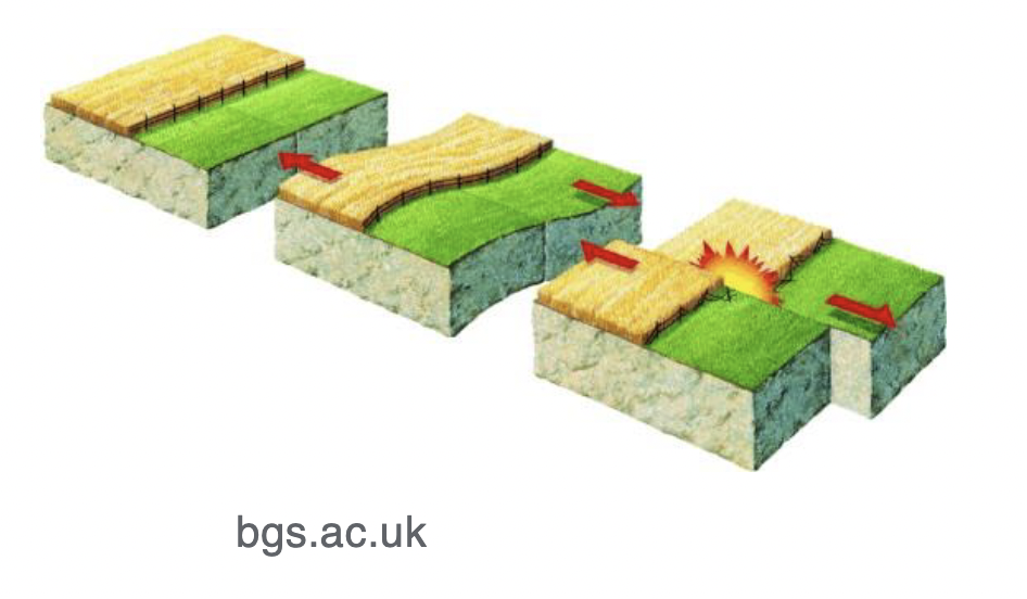
This process is also known as elastic rebound
- Elastic rebound: when the rocks release pressure, they rebound to their undistorted (though now broken) condition
- The breaking and shifting of rocks results in the creation of faults
- Fault: a crack in the rocks along which there has been some kind of movement of the rocks
- A crack is only a fault of the rocks have shifted along the fault
- Faults may shift vertically or horizontally
- The continuous vertical shifting of rocks along faults can produce significant mountain ranges
- Eg. the Teton Mountains of Wyoming
- Every movement of rocks along a fault produces an earthquake; bigger shifts tend to produce bigger earthquakes
- Most earthquakes originate from fault shifts; most fault shifts occur underground
- The point where the fault moves (the point from which the earthquake originates) is called the focus
- The point on the ground surface, directly above the focus, is called the epicenter
- This is marked on most maps as the geographic location of earthquakes
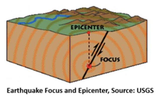
- The energy originates from the focus and travels outward in all directions with wavelike motions
- Seismic waves: the waves of energy traveling through the surrounding rocks
- There are multiple kinds of seismic waves
- Surface wave: a seismic wave that travels on the ground surface
- Sometimes have visible vertical movements in intense earthquakes

- Body wave: a seismic wave that travels through the earth
- Two main types of body waves are p- and s-waves (primary and secondary)
- P-wave: a body wave that travels by compressing and stretching the rocks in a push/pull motion

- S-wave: a body wave that travels through a shaking motion (vertical or horizontal)
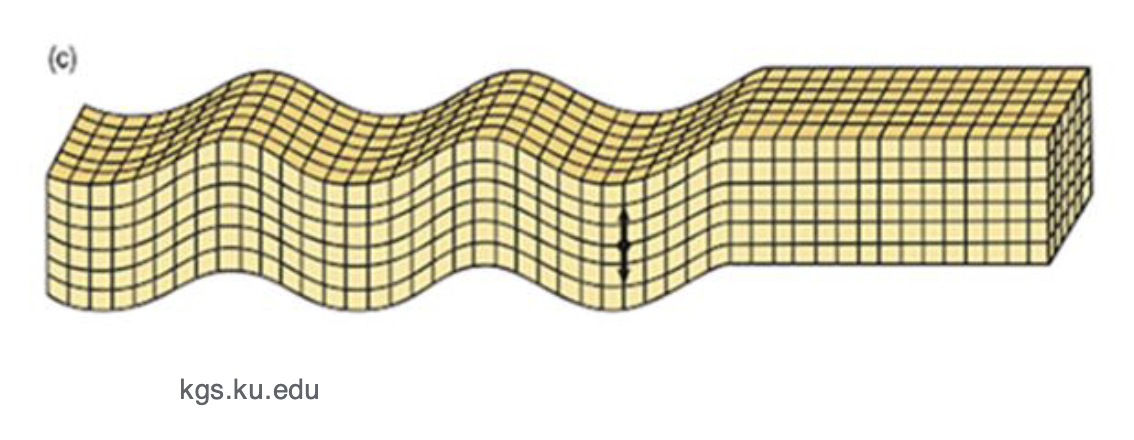
- P-waves travel faster than s-waves
- Earthquakes may also result from the movement of magma rising under a volcano
- Rocks shift, having been deformed by the rising magma and release built-up energy
Measuring Earthquakes
- Seismology: the study of earthquakes
- Seismologist: a geologist who studies earthquakes
- Seismograph: a device used to measure the intensity of earthquakes
- A simple scientific device based on physics (specifically the principle of inertia)
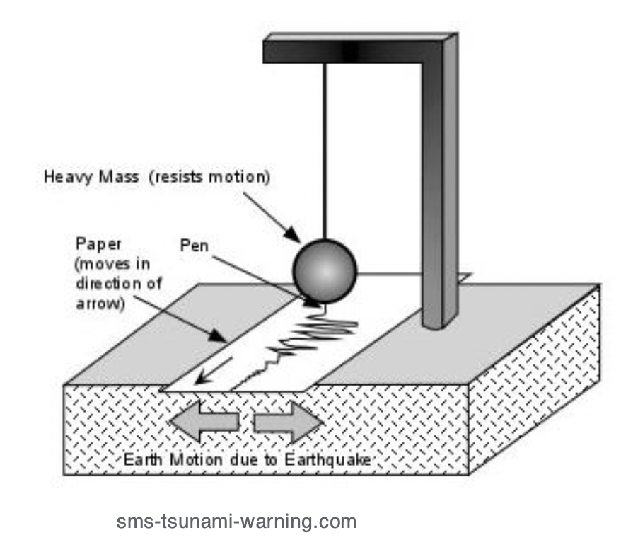
- When an earthquake happens, the ground shakes, shaking the support arm and the wire; the suspended weight remains motionless (inertia)
- If a marking device (eg. a pen) is attached to the weight, the pen also remains motionless
- If paper is added to move steadily below the pen, the paper records the movement of the ground
- Seismogram: the paper record of ground motion recorded by a seismograph
- A simple scientific device based on physics (specifically the principle of inertia)
- Seismographs produce direct records of the amount of ground motion, recording amounts of such motion and timing of seismic events
- Seismometer: a modern version of the seismograph replacing a pen and paper with an electronic transducer
- Ground motion is recorded as a digital signal which can be transmitted by radio to a central office
- Can be set up anywhere in the world
Locating Earthquakes
- Measurement devices record the arrival of surface, p-, and s-waves
- Speed of waves (fastest to slowest):
- P-wave
- S-wave
- Surface wave
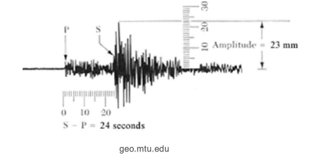
- Based on known travel times, the time difference between the p- and s-waves can be used to estimate the distance from the seismometer to the earthquake’s epicenter
- This just measures distance, and does not indicate which direction the quake came from
- To determine epicenter location, distance measurements are needed from at least three seismic stations to triangulate the center
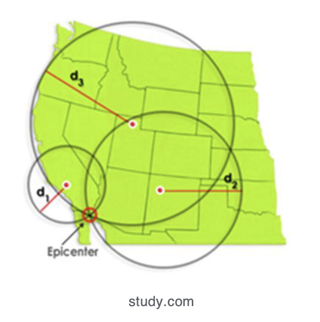
- Because the current seismic network is so large, it’s possible to develop three-dimensional information about earthquakes’ locations
The Size and Strength of Earthquakes
- Seismic data also provides methods of estimation for earthquake size
- The two traditional measurements are intensity and magnitude
- Earthquake intensity: the amount of ground motion and force of shaking
- Intensity measurements can be estimated from seismic measurements, but are more commonly estimated from damage done by earthquakes
- Traditional scale — Mercalli Scale (1-12)
- Because of how seismic waves spread from the epicenter, the intensity dissipates farther from the epicenter (modified somewhat by geological characteristics)
- Intensity measurements provide useful information about the immediate effects of an earthquake but are not helpful in comparing earthquakes from place to place or time to time
- Earthquake magnitude: the amount of energy released when the fault shift releases the built-up pressure that had been stored in the rocks
- Not possible to directly measure this energy release (fault movements happen far underground)
- Estimates the energy release by the indirect evidence of the seismic waves
- Richter Scale: the traditional method of measuring magnitude (1-10)
- Richter used seismograph records and measured the size of the tracing of ground motion on the seismogram
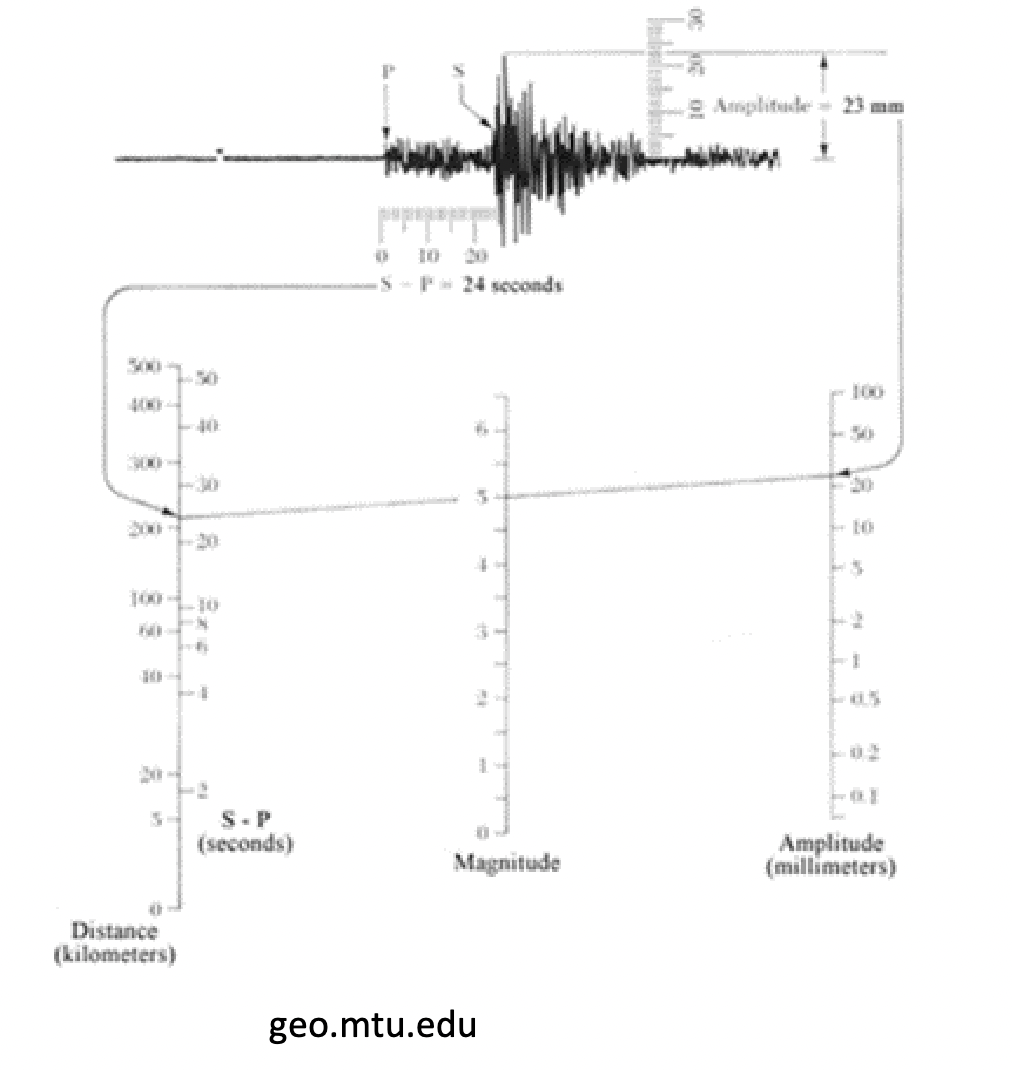
- Connecting the two measurements on the graph yields the magnitude estimate on the middle line
- The Richter scale is logarithmic; each step of 1 is a multiple of 10 on the log scale
- Eg. an earthquake with a magnitude of 4 is…
- 10x smaller than a 5
- 100x smaller than a 6
- 1,000x smaller than a 7
- And so on
- Recently, there’s been some dissatisfaction with the Richter scale → large earthquakes tend to cluster close together and are difficult to differentiate
- Moment Magnitude Scale: a new magnitude scale just like the Richter scale, but larger earthquakes are more spread out
- Measurements are based on:
- The amount of displacement along the fault (how much the fault moves)
- The size of the fault line
- The density of the rocks around the fault line (harder rocks emit energy more efficiently than softer rocks)
- The necessary measurements are more complicated but can be estimated from seismic data with modern technology