Exam 1 Study Guide - ESCI 1101 🌍
Chapter 1:
How is physical geography defined?
Physical geography is the study of all the natural aspects of Earth as our habitat and home.
What are the four major spheres of the Physical Geography?
The four major spheres are of Physical Geography include: Biosphere (life), Lithosphere (solid rock in Earth’s core), Atmosphere (sky), Hydrosphere (water)
What is an open system, closed system, and what are examples of each?
Open system: energy and materials can truly cross the boundaries of the system (there is inputs and outputs).
Example of open system: The planet Earth, the bodies of living beings, rivers and streams that receive water from rain and other sources of flow.
Closed system: system in which energy and materials can not the cross the boundary of the system.
Examples of closed systems: The planet Earth is a closed system to matter, closed biome decoration, a sealed thermos.
What is system equilibrium?
System equilibrium is when the inputs and outputs are balanced by each other in a system.
What is feedback? What are examples of feedback?
Feedback is an adjustment in one part of a system in response to a change that occurred in another part of the system.
Examples of feedback: sweating (negative feedback), greenhouse effect increasing as CO2 increases (positive feedback)
Chapter 2:
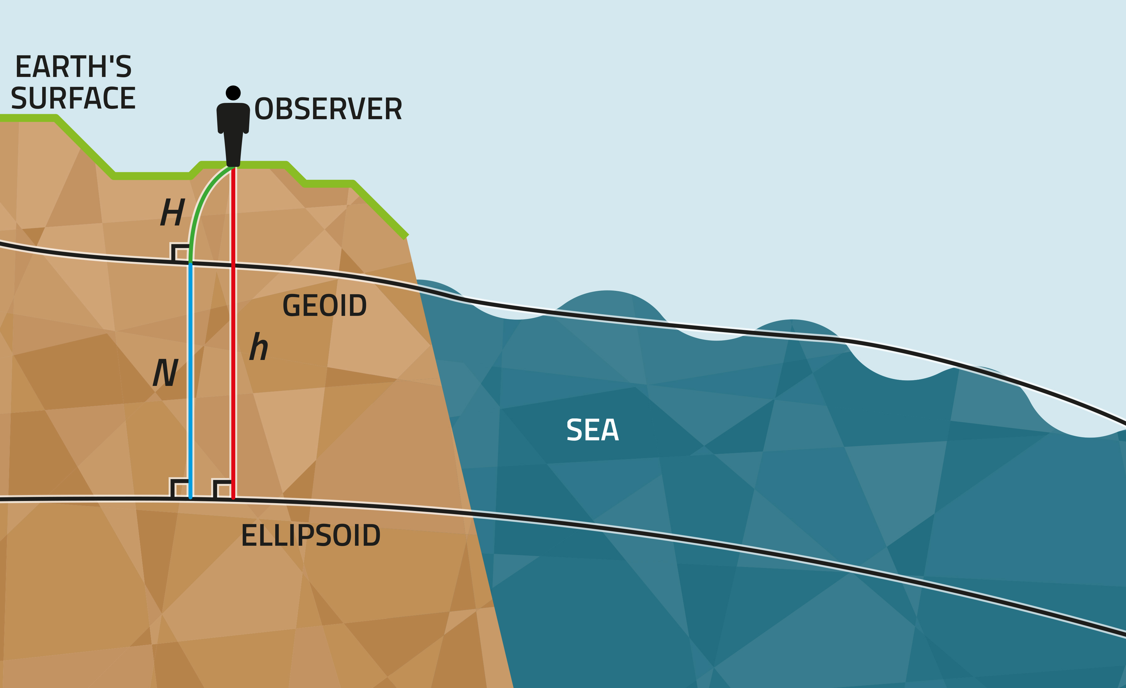
What is a geoid?
A geoid is the hypothetical shape of the Earth, coinciding with the mean sea level and its imagined extension under (or over) land areas.
Why isn’t the Earth a perfect sphere?
The Earth is not a perfect sphere because it is spinning on its axis and has been spinning for a long time and this causes a centrifugal force that makes the Earth bulge at the equator and flatten at the poles. It is instead an oblate spheroid, which is a squished sphere.
What are latitude and longitude?
Latitude: angular distance (distance measured in degrees) north or south of the parallel (the max degrees being 90°S and 90°N).
Longitude: the angular distance between east and west of the prime meridian
What are Parallels and Meridians?
Parallels: lat. lines that circle on the globe connecting all points of equal latitude; the equator is the only parallel that’s a great circle.
Meridians: a line of longitude that forms half of a great circle on the globe and connects all points of equal longitude.
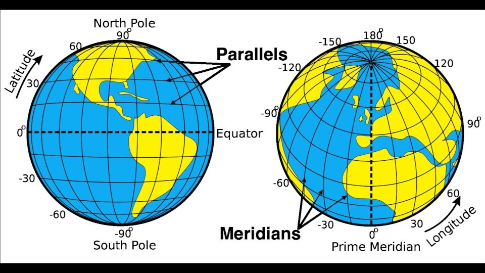
What’s the difference between latitude and longitude and parallels and meridians?
Latitude is the actual angle between the equator and a point on Earth’s surface while parallels are the circles on Earth’s surface that joins points of the same latitude. While meridian is an imaginary great circle on the surface that passes through the poles and longitude is the angular distance measured east or west of the prime meridian.
What is the significance of the Tropics of Cancer/Capricorn and the Artic/Antarctic circles?
These are a part of the five major latitudes on the geographic grid system. The Tropic of Cancer are located at 23.5 degrees north and 23.5 degrees south (Tropic of Capricorn). The sun is directly above the Tropic of Cancer at the summer solstice (June 21), which means that this tropic is the farthest point North on Earth when is overhead at noon. The Tropic of Capricorn marks the southernmost point on Earth where the sun is directly overhead at noon. The Artic Circle marks the southern limit of the area within which the sun does not set (June 21) or rise (December 21) for one day or more each year. In direct opposition of this, The Antarctic Circle marks the northern limit of the area where the sun does not rise (June 21) or set (December 21) for one or more days each year.
What is cartography?
Cartography: the science of mapmaking
What is a thematic map?
Thematic map: a map designed to focus attention on the spatial distribution and pattern of one feature (or a few related ones).
What types of data can be put on a map?
Climate data, vegetation spatial patterns/distributions, soils, earthquake epicenters, lightning strike locations, rainforest, tornado patterns, etc.
What is a map projection? Understand the limitations.
Map Projection: any presentation of the spherical Earth on a flat surface.
Limitations of map projections include: features of given areas, accurate area relationships, true compass directions, uniform distance relationships, or some combo of these other limitations.
What is a map scale? Provide examples.
Map Scale: an expression of the relationship between a distance on the ground and the same distance as it appears on the map.
Verbal Map Scale: a statement about the distance on a map (1 in: 1 mile)
Graphic Bar Scale: a linear graphic that showcases the distances and how they translate onto the map.
Representative Fraction (RF): a ratio between unit of distance on the map to the units represented in reality.
Explain gradients on a contoured map.
Contour lines are isolines that connect points on a map that are at the same elevation above mean sea level (or below sea level) and they follow constant alteration levels on a map. Closely spaced contour lines represent a steeper slope. The gradients on a contoured map are the greater rate of vertical change per unit of horizontal distance as you go up the topography on contour maps.
Why was standard time put into place?
Standard time was put into place so that the entirety of the world could coordinate travel times, weather forecasts instead of running on uncoordinated local time. In 1884 The International Meridian Conference in Washington DC, set standardized time zones and established the prime meridian.
What is remote sensing? GIS? GPS?
Remote sensing: this is the collection of information and data about the environment from a distance. Some examples of it are anything from photography to radar to Infared.
Why is mapmaking so difficult? Why can’t we simply replicate the globe in 2D (size and shape)?
Chapter 3:
When is the Earth closest/farthest from the sun? Names for this.
What is solar radiation?
What is terrestrial radiation?
What is the EM spectrum? What are the types of radiations and strengths?
The Electromagnetic Spectrum is the full range of wavelengths of electromagnetic energy, portions of which constitute such bands as visible light, ultraviolet radiation, infrared radiation, and others.
Radio waves: longwave radiation
Microwaves: longwave radiation
Thermal Infrared waves: longwave radiation
Visible light: shortwave radiation
Ultraviolet waves: shortwave radiation
X-rays: shortwave radiation
Gamma rays: shortwave radiation
What is shortwave vs. longwave radiation?
What are the two reasons that the tropics receive so much more radiation than the poles?
The sun is directly overhead in the equatorial and tropical regions throughout the year. The Sun’s angle is much lower in the poles, so the rays of energy are spread out over a much larger area and are therefore less intense.
The tropics also receive more radiation than they emit.
What is revolution/rotation?
Rotation: the spinning of an object around its own axis
Revolution: the movement of an object around another object or center
Why do we have seasons on Earth?
Seasons are controlled by the amount of solar energy striking the tilted planet at any given time. Because the earth’s orbit is an ellipse instead of a circle, the actual distance from Earth to the sun varies during the year.
What is Axis Parallelism?
Axis Parallelism describes the concept of the tilt of the Earth on its axis not changing from 23.5 degrees no matter what.
What changes from season to season?
The length of daylight and the intensity of sunlight that reaches the Earth’s surface changes from season to season.
What is a solstice/equinox, what months do they occur?
A solstice is the time or date at which the sun reaches its maximum or minimum declination marked by the longest and shortest days (June 21 and December 21)
The equinox is the time or date at which the sun crosses the celestial equator, when day and night are of approximately equal length (September 22 and March 20).
You can divide the atmosphere by temperature/function/composition, what are these regions?
The troposphere: The lowest layer of the atmosphere that exhibits a steady decrease in temperature w/ increasing altitude and contains virtually all atmospheric dust and water vapor.
The stratosphere: this layer is characterized by a fairly constant temperature and ozone concentration. The ice clouds and ozone layer are here. The temperature increases as you move up through the stratosphere because the ozone layer absorbs UV radiation and the absorbed energy results in releases of heat.
The mesosphere: This layer was characterized by temperatures that decrease regularly with the altitude.
The thermosphere: This is the uppermost layer that extends from the mesopause to outer space.
What are the primary gases that make up the atmosphere? Constant vs. Variable
Constant primary gases:
Nitrogen: 78%
Oxygen: 21%
Argon: 1%
Variable Gases:
Water Vapor: 0-4% by volume)
Carbon Dioxide (0.04% by volume)
Methane
Nitrous Oxide
What is the difference between the homosphere and the heterosphere?
The homosphere is the lower part of the atmosphere for up to about sixty miles, whereas the heterosphere is the upper part of the atmosphere. The homosphere is a region of the atmosphere where the composition of gases is relatively constant, whereas the heterosphere is a region of the atmosphere where the composition of gases varies with altitude.
What is the lapse rate? What is the average lapse rate?
The lapse rate is the rate at which air temperature falls with increasing altitude. The average lapse rate is highly variable, and it averages about 6.5 degrees Celsius per kilometer in the troposphere. The temp tends to decrease 3.5 degrees Fahrenheit per 1,000 feet of altitude.
What is the ionosphere vs ozonosphere (ozone layer)?
The ionosphere is the layer of ionized gases concentrated between 80 km and outer limits of the atmosphere. It helps to shield Earth from harmful shortwave radiation and also aids in transmitting broadcast signals. The ozonosphere is the ozone layer which is a concentration of ozone gas in a layer between 20 and 50 km above the Earth’s surface.
Chapter 4:
What is insolation, which areas of the earth receive more and why?
The tropics receive the most insolation are the tropics and the subtropical deserts. This is because these areas have the least cloudiness, the highest angle of incidence of the sun’s rays and the longest duration of sunlight. They are located at the equatorial region received the highest average insolation throughout the year.
What is the reflection, absorption, refraction, transmission of radiation?
Absorption is the transformation of radiant power to another type of energy, usually heat, by interaction with matter. Reflection, transmission, and scattering leave the frequency of the radiation unchanged.
What is albedo?
What kind of surfaces have high albedos?
How do clouds both heat up and cool down the planet?
Clouds cool the Earth’s surface by reflecting incoming sunlight. The clouds warm Earth’s surface by absorbing heat emitted from the surface and re-radiating it back down towards the surface.
What is the greenhouse effect?
What is the conduction/convection of radiation?
Conduction is the transfer of heat within a body or between adjacent matter by means of internal molecular movement.
Convection is the process by which a circulation is produced within an air mass of fluid body (where heated material rises and cooled material sinks). These convection currents account for much of the vertical transfer of heat within the atmosphere.
What is temperature?
What are the differences in the temperature scales?
There are three main temperature scales: Fahrenheit, Celsius, and Kelvin. The boiling point of Fahrenheit is 212 degrees and 100 degrees Celsius. The freezing point of Fahrenheit is 32 degrees and 0 degrees Celsius.
How do thermometers work? Mercury versus alcohol.
Mercury thermometers measure temperature by the expansion and contraction of mercury in a glass tube.
Alcohol thermometers measure temperature by using the expansion and contraction of alcohol in a glass tube. This tube has a bulb at the end that when the temp rise the alcohol expands and moves up the capillary.
What controls the temperature at a given location on earth?
The latitude controls the temperatures as the polar regions have colder annual temperature than any other location on earth. Temperature also decreases with altitude. Water heats and cools more slowly than land so coastal areas tend to have milder temperatures than inland areas.
What does latitude do? Surplus of energy? Deficit?
What is the thermal equator? How does it shift annually?
The thermal equator is a belt encircling Earth that is defined by the set of location having the highest means annual temperature at each longitude around the glove.
What does the evaporation do to the temperature?
What is transparency? Water vs. Land.
What is heat capacity? Water vs. Land.
What’s the difference between marine and continental climate?
Marine climate is generally milder annual temperatures because there is a breeze coming in from the sea and the continental climate is also subject to more fluctuations in overall daily temperatures and has hotter climates.
What and where is the Gulf Stream Current?
The gulf stream current is a strong current in the west Atlantic Ocean
Know which coastal cities have bigger swings in annual temperature and why.
What does altitude do to the temperatures?
The higher the altitude the lower the temperatures.
What are the heat index and wind chill?
Heat index is the what the temperature outside feels like when the actual temperature and the relative humidity are taken into account.
The wind chill is the actual temperature and the cooling of the skin as it is exposed to air to determine what the temperature feels like to humans and it is always a lower temperature then the actual temperature.
Chapter 5:
What is air pressure? Zonal/Meridional Flow? Wind?
How does a barometer work?
Understand how wind directions work (northerly, easterly, etc.)
The winds are always named for the direction that they are coming from.
Leeward, Windward, Upslope, and Downslope — meanings
Windward: facing the wind or situated on the side facing the wind
Leeward: side of the mountain facing away from the wind.
Upslope: winds moving up a hill or mountaintop
Downslope: wind that is directed down a hill or mountaintop
What are prevailing winds?
Prevailing winds are surface winds that blow predominantly from one direction.
What is the pressure gradient force and how does it create wind?
The pressure gradient force moves the wind from high pressure to low pressure areas.
The stronger the pressure gradient force means the stronger the winds.
The weaker the pressure gradient force means the weaker the winds.
What is the Coriolis force? What does it do in the northern hemisphere?
The Coriolis force always blows towards higher pressure. The Coriolis force is a frictions force that acts on objects in motion within a frame of reference.
What does friction do to the wind?
Friction slows down the wind.
How does friction affect the Coriolis force?
Friction reduces the windspeed, which reduces the Coriolis effect.
What is geostrophic wind?
Geostrophic wind is the theoretical wind that would occur if there was an exact balance between the Coriolis affect and the pressure gradient force (flows toward low pressure), while the geostrophic winds blow towards
Where do we see geostrophic wind occur?
Geostrophic wind occurs in middle latitudes.
What is cyclonic flow? (low pressure)
What is anticyclonic flow? (high pressure)
What do surface winds actually look like?
How do you determine the windspeed?
What is the convergence/divergence? Which pressures are they associated with?
How do winds behave at High and Low pressure?
What is the ITCZ, where is it, how does it shift?
What is the monsoon? What areas of the world experience it mostly?
Understand in detail how the Hadley cell works, pressures, winds, trade winds, jet stream.
What is the jet stream?
The jet stream is narrow bands of strong winds that blow from west to east in higher altitudes near the tropopause.
Where does the jet stream move season to season? Know the basics of the jet stream.
Understand how land/sea breezes and mountain breezes work.
Sea breezes: wind moves from the water onto the land during the day as the wind moves from the high pressure water to the low pressure land area
Mountain breezes: wind moves form the land onto the water during the night as the wind moves from the land that is now a high pressure area as it releases heat to the low pressure water.
What is upwelling and downwelling?
What causes the surface of the ocean to circulate?
What are deep currents vs. surface currents?
What are El Nino and La Nina? What happens during each event?
El Nino: is the eastward movement of warm countercurrents in a 22 year cycle
La Nina: is the upwelling of colder water currents near the western side of the americas
Chapter 6:
Where is most of the earths water? Water in equilibrium
The oceans
Understand the phases of water and the changes between them (names).
Know the latent heats of vaporization and condensation.
What is relative humidity?
Understand the general daily pattern in R.H.
What is the saturation?
Can warm air hold more water vapor than cold air?
What is vapor pressure?
How do we classify clouds?
Alto, strato, cirro (from lowest to highest levels)
Clouds are classified by shape and size
What are the different types of fog you can have?
Advection and radiation fog
Understand what rising/sinking (expansion/contraction) of air is does.
What does the term adiabatic mean?
Adiabatic means that a parcel of air compresses and warms w/ no interchange of heat with the atmosphere around it.
What is the difference between the dry and moist adiabatic lapse rates? When do you use them?
How is stability defined in the atmosphere?
How is precipitation formed? Collisions-Coalescence and Bergeron
Snow, Sleet, Freezing Rain, Rain —know the differences.
What are the primary lifting mechanisms in the atmosphere?