AP Human GEO FLASHCARDS
 Introduction to Agriculture
Agriculture
The purposeful cultivation of plants or raising of animal to produce goods for survival.
Climate regions (based on temperature and precipitation) help determine agriculture production.
Settlement Patterns and Survey Methods
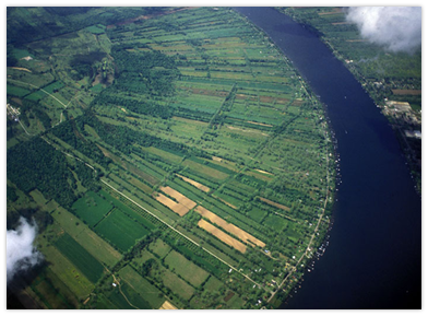
Rural settlement Patterns
Clustered (Nucleated on picture)
Dispersed
Linear
Long Lot
French
Elongated
Mostly found along bodies of water.
Metes and Bounds
Uses landmarks in measurements
Measured in paces and feet
Irregular shapes, not as geometric
East of the Mississippi river and mid-Atlan
tic
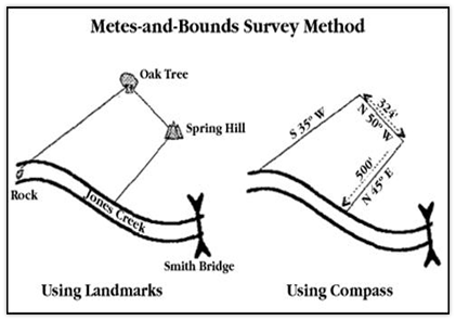
Township and Range
Geometric and use of longitude and latitude
West of Mississippi river after Louisiana purchase (1803)

Agriculture has changed over time because of cultural diffusion and advances in technology.
Early hearths of domestication of plants and animals arose in the Fertile crescent and several other regions of the world, including the Indus River valley, Southeast Asian, and Central America.
Patterns of diffusion, such as the Columbian Exchange and the agricultural revolutions, resulted din the global spread of various plants and animals.
First Agricultural Revolution
AKA Neolithic Revolution
10,000-14,000 years ago
Transition of human societies from hunter-gatherer to farming.
Plant and animal domestication (farming and raising animals).
S and SE
Early domestication of root crops
SW Asia (Fertile Crescent)
Early domestication of seed crops
First planned cultivation of seed crops.
Surplus of wheat and barley
Seed selection and crops/livestock.
Subsistence farming
Growing enough food to survive
Shifting cultivation (slash and burn)
Use of fire to clear land and get nutrients, use land and ten abandon.
Columbian Exchange
New World and Old World.
The Second Agricultural Revolution
Agriculture has changed over time because of cultural diffusion and advances in technology.
New technology and increased food production in the second agricultural revolution led to better diets, longer life expectancies, and more people available for work in factories.
17th and 18th Century (some overlap with industrial Revolution)
Innovations, improvements, and techniques in order to increase output.
Seed drill, livestock, breeding, fertilizer, tools, mechanization.
As more people moved to cities to work in factories, increased agricultural productivity met the new demand and there was surplus.
Better diets=longer life spans.
Agriculture has changed over time because of cultural diffusion and advances in technology.
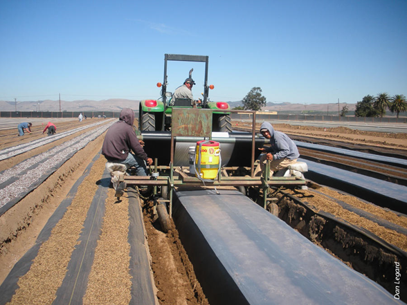
The Green Revolution was characterized in agriculture by the use of high-yield seeds, increased use of chemicals, and mechanized farming.
The Green Revolution had positive and negative consequences for both human populations and the environment.
20th Century-present
The development of higher-yield and fast-growing crops through increased technology, pesticides, and fertilizers. E
Spreads from developed world to developing world.
Food supply keeps up with population increase.
Mechanization
Specialization
Hybridization
GMO's
Chemical Technology )herbicides, pesticides, artificial fertilizers, irrigation, etch).
Industrialization of food production.
Disadvantages
Dependency on chemicals for production
Soul erosion
Vulnerability to pests
Water shortages
Micronutrient deficiencies
Non sustainable methods.
Agricultural Production Regions
Subsistence Agriculture
Production of food primarily for consumption by the farmer's family (less developed/developing countries).
Commercial Farming
Production of food primarily for sale off the farm (developed/more developed countries).
Three factors that distinguish subsistence from commercial
Percentage of farmers in the labor force
The use of machinery
The size of the farm
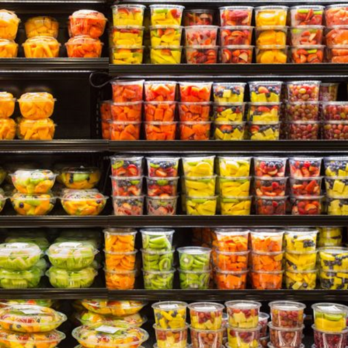
Mono-cropping/monoculture
Dependence on a single agricultural community.
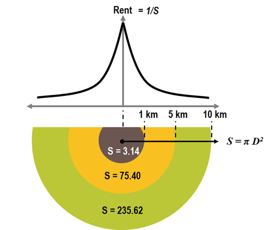
Bid Rent Thery
Intensive and extensive farming practices are determined, in part, by land costs.
he price and demand for land changes as it gets further away from the market.
There is a trade-off between accessibility and land cost.
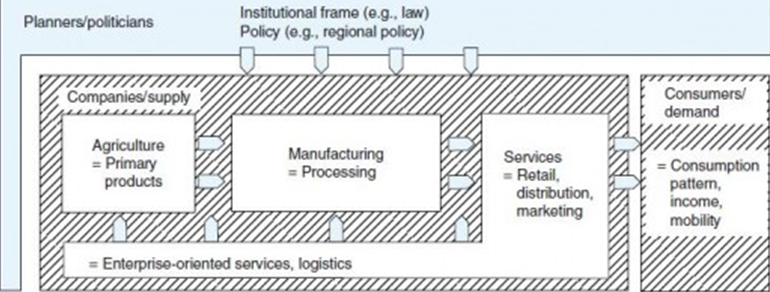
Spatial Organization of Agriculture
Availability of resources and cultural practices influence agricultural practices and land-use patterns
Large-scale commercial agricultural operations are replacing small family farms
Complex commodity chains link production and consumption of agricultural products
Technology has increased economic of scale in the agricultural sector and the carrying capacity of the lad.
Large-scale commercial agricultural operations are replacing small family farms.
Agribusiness:
Businesses that provide the vast array of goods and services that support the agricultural industry.
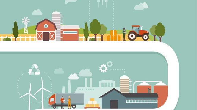
Commodity Chain
A linked system that gather resources, convert them into goods, package them for distribtuion, disperse them, and sell them on the market.
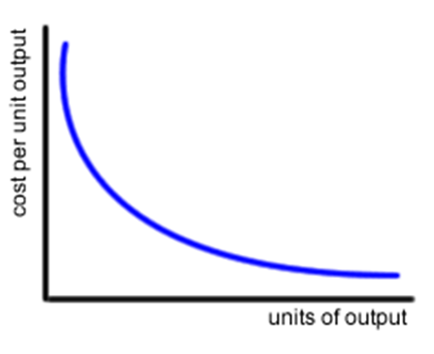
Economic of scale
The reduction in the per unit cost of production as the volume of production increases
The more you produce, the cheaper it gets.
The Global System of Agriculture
Availability of resources and cultural practices influence agricultural practices and land use patterns
Food and other agricultural products are part of a global supply chain
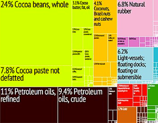
Some countries have become highly dependent on one or more export commodities.
The main element of global food distribution networks are affected by political relationships, infrastructure, and patterns of world trade.
Food and other agricultural products are part of a global supply chain.

Some countries become highly dependent on one or more export commodities.
21 in Sub-Saharan Africa, 14 in Latin American, and the Caribbean, and 6 in the South Pacific islands.
Sugar (7)
Coffee (6)
Bananas (6)
Cotton(5)
Cocoa beans (4)
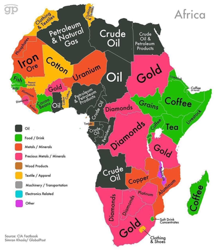
The main element of global food distribution networks are affected by political relationships, infrastructure, and patterns of world trade.
Agricultural innovations
Biotechnology
Genetically modified Organisms (GMOs)
A plant or animal with specific characteristics obtained through the manipulation of genetic makeup.
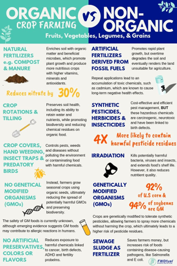
Organic Farming:
Fair-Trade
The movement that tries o provide farmers and workers in peripheral and semi-peripheral countries with a fair price for their products by providing more equitable trading conditions.

Urban Farming
Community-supported Agriculture (CSA)
Individual Food choice:
Value-added specialty products
Goods have some other products in them or item attached to sell for more $
Challenges of Contemporary Agriculture
Food insecurity
Food deserts
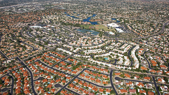
Suburbanization/Urban Sprawl
Suburbs taking over fertile agricultural land.
Women in Agriculture
Agricultural production and consumption patterns vary in different locations, presenting different environmental, social, economic, and cultural opportunities and challenges.
The role of females in food production, distribution, and consumption varies in many places depending on the type of production involved.
Unit 6
The Origin and Influences of Urbanization
The presence and growth of cities vary across geographical locations because of physical geography reasons and resources.
Explain the processes that initiate and drive urbanization and suburbanization.
Site and situation influences the origin, function and growth of cities.
Changes in transportation and communication, population growth, migration, economic development, and government policies influences urbanization.
Urbanization:
The buildup of the central city and the suburban areas. Involves the movement of people and the clustering of people in towns and cities.
5 Hearths of Urbanization
Mesoamerica
Nile Vally
Mesopotamia
Indus Valley
Huang He River Vally
The Origin and Influences of Urbanization
Early cities were in agricultural hearths (crop surplus allowed for large populations)
Later cities were built along trade routes.
Site:
Absolute location, static location often chosen for trade, defense, or religion.
City sites include: hilltop, river confluence, fall-line, oasis, harbor, etc.
Situation:
Relative location, a city's place in the region and the world around it.
Links to the rest of the region/world
Example: Istanbul controlling the straits and land bridge between Europe and Asia.
Influences on Modern Urbanization
Transportation and Communication
Population Growth
Migration
Economic Development
Government Policies
Cities across the World
The presence and growth of cities vary across geographical locations because of physical geography and resources.
Explain the processes that initiate and drive urbanization and suburbanization.
Megacities and megacities are distinct spatial outcomes of urbanization increasingly located in countries of the periphery and semi periphery.
Process of suburbanization, sprawl, and decentralization have created new land-use forms-including edge cities, exurbs, and boom burbs- and new challenges.
Megacities
Mostly in periphery/semi-periphery countries
High population growth and migration
Problems
Chaotic and unplanned sprawling growth
Pollution
Widespread poverty
Megacities
Population of 20+ million
Growing without adequate planning and services
Expanding through the emergence of vast slums
Drawing populations by the millions.
Cities across the world
Because of suburbanization, sprawl, and decentralization, new land-use forms have emerged.
Edge cities: Cities located on the outskirts of larger cities.
Exurbs: A prosperous area beyond the suburbs.
Boom burbs: Large, rapidly growing areas of more that 100,000 residents that are not the biggest city in their region.
Cities and Globalization
Globalization:
The expansion of economic, cultural and political processes on a worldwide scale.
World System Theory:
Describes the spatial and functional relationships between countries in the world economy.
Core: Advanced Countries:
Semi-Periphery: Middle
Periphery: Less developed countries
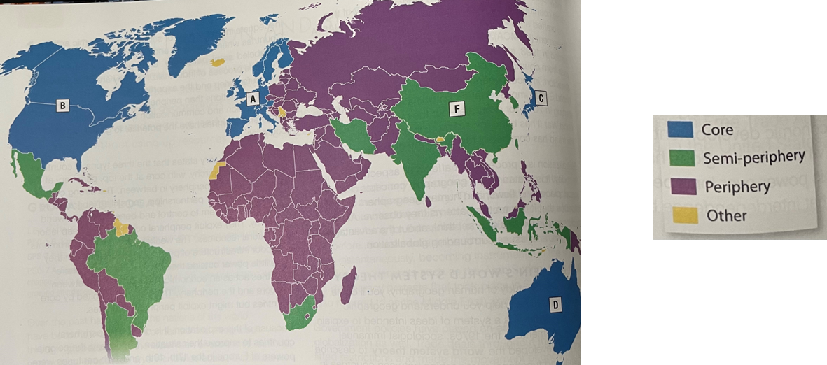
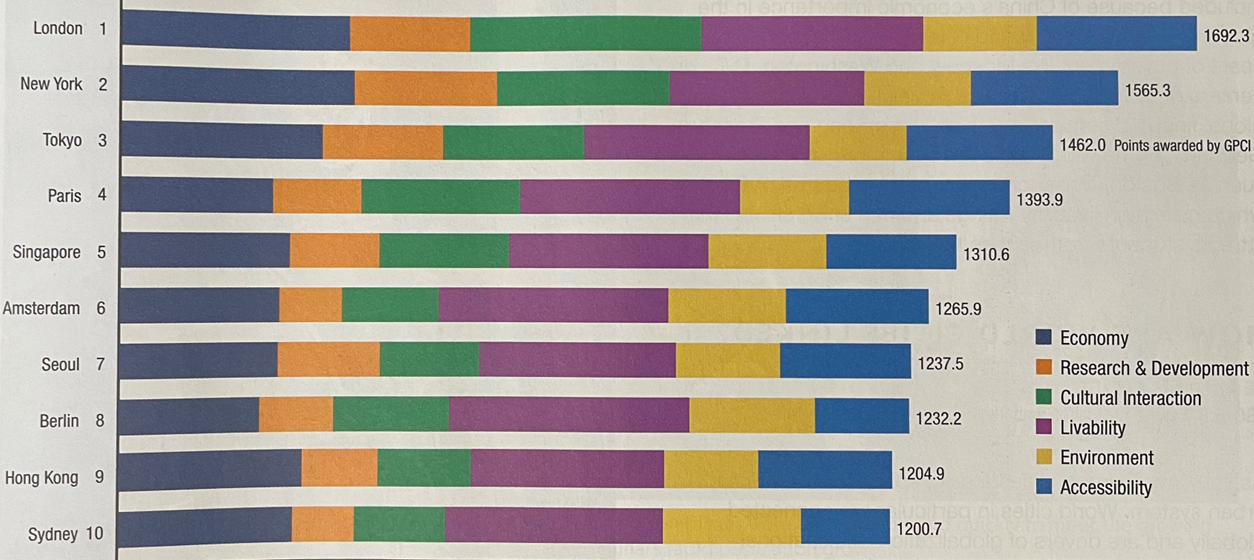
World Cities:
Centers of economic, cultural and political activity that are strongly interconnected and together control the global system of finance and commerce.
Top Tier: NYC, Landon, and Tokyo.
Not always the largest cities but have important services such as banking, advertising, accounting, and legal services.
The size and Distribution of Cities:
Cities and towns are part of interdependent systems that function at regional, national, and international scales.
Traditionally, transportation linkages were most important. Now communication linkages are equally as important.
Geographers studying the relative sizes and spatial relationships of cities have identified common attributes and features and developed models described the urban network.
Rank-size rule
Primate city rule
Gravity model
Christelle's central place theory
Note: These models do not apply to every situation.
Rank-Size Rule
The country's nth-largest settlement is 1/n the population of the largest settlement
Example: the country's 2nd largest settlement is 1/2 the population of the largest settlement.
Primate City
A country's leading city, with a population that is disproportionately greater than other urban areas within the same country.
Indicates unbalanced levels of development because people are moving to one city for economic opportunities.
Examples: Mexico City
Gravity Model
Used to explain the relationship between cities of various sizes
Larger cities will interact more with each other than slammer cities.
Larger cities will draw interaction from smaller cities nearby.
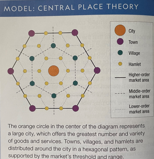
Christelle's Central Place theory
Main function of cities and towns is to provide goods and services to the surrounding area
Threshold: The number of people needed to support a certain good or services.
Range: The distance that someone is willing to travel for a good or service.
Hight order good/services: More expansive, desirable, or unique. Located in cities
Low order good/service: More common goods/services like grocery stores, barber shops, etc.
How far are people willing to travel for a good/service.
The internal structure of cities
The presence and growth of cities vary across geographical locations because of physical geography and resources
Explain the internal structure of cities using various models and theories
Models and theories that are useful for explaining internal structures of cities include the Burgess concentric-zone model, the Hoyt sector model, the Harris and Ullman multiple-nuclei model, the galactic city model, bid-rent theory, and urban models drawn from Latin America, Southeast Asia, and Africa
How are cities laid out?
Social, economic, and spatial processes determine the land-use structure of cities.
People want to maximize their access to jobs, homes, goods, and services.
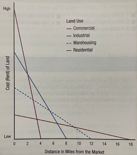
Big Rent Theory
Same Model as the agriculture unit
Land closer to the central business district (CBD) is more expensive because it is in a more desirable location.
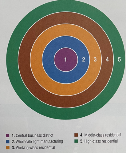
Burgess Concentric-Zone Model
City grows outward from CBD in a series of concentric rings
Zone 1: Most economic activity
Zone 2: Transitional zone, light manufacturing and low-income housing.
Zone 3: Working class housing (near factory jobs), less population density than Zone 2:
Zone 4: Middle class residential
Zone 5: Commuter zone and high class residential lowest population density.
Chicago and Philadelphia.
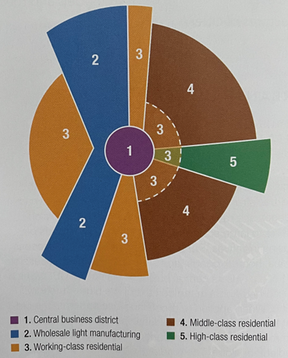
Hoyt Sector Model
Improves Burgess. Zones form in sectors rather than concentric rings
Wedge shaped sectors generally develop along transit routes
Zone 3 (working class residential) develops alongside zone 2 (ligt manufacturing/factory jobs)
Sectors grow and change over time, better homes will be on the periphery and lower income housing closer to the CBD.
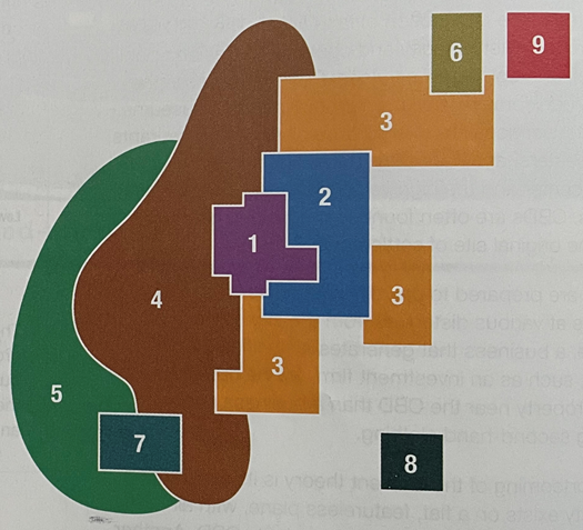
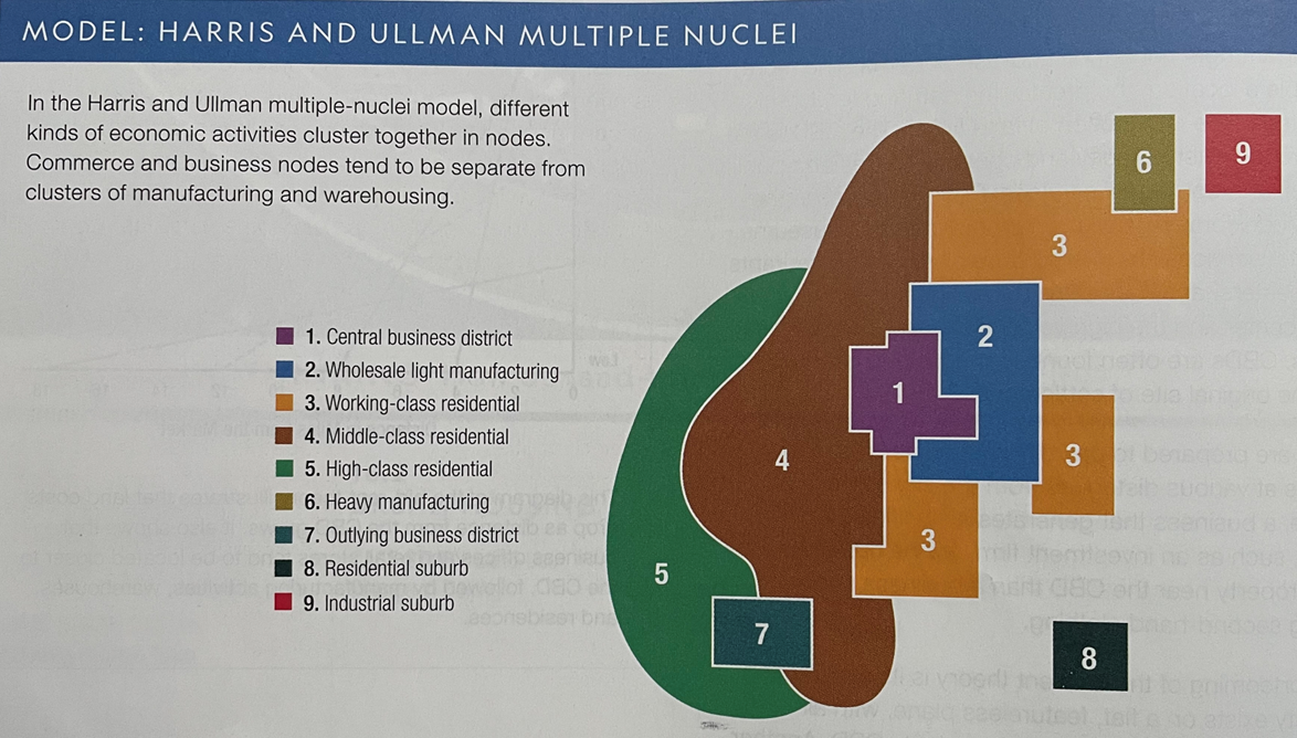
Harris and Ulman Multiple Nuclei Model
Land use varies depending on local context. Different that Burgess and Hoyt
Newer faster growing cities
Location and growth of nodes rely on 5 factors
Highly specialized activities involve specific sites (industry must be near major transport routes)
Related businesses find it beneficial to be near each other forming financial, legal, health districts etc.
Location and growth of nodes rely on 4 factors
Negative consequences of commerce and industry. Some activities do not coexist and repel another.
Economic considerations influence the formation of other kinds of nodes (areas near CBD also have expensive housing, warehouses are located on the outskirts of a city).
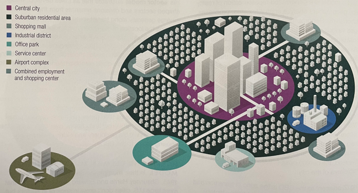
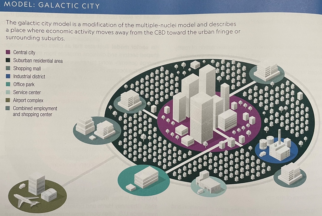
Galactic City Model
Cities have a traditional downtown and loose coalitions of other urban areas
Edge cities
Areas include centers for entertainment, sports, education, R&D, edge cities, newer business centers away from traditional downtown.
Airport on outskirts
Examples: Detroit, LA, and DC metro area.
Latin America City Model
Started during colonization of Latin America. Church, government, businesses at the center with a grand boulevard for the wealthy that extended outward.
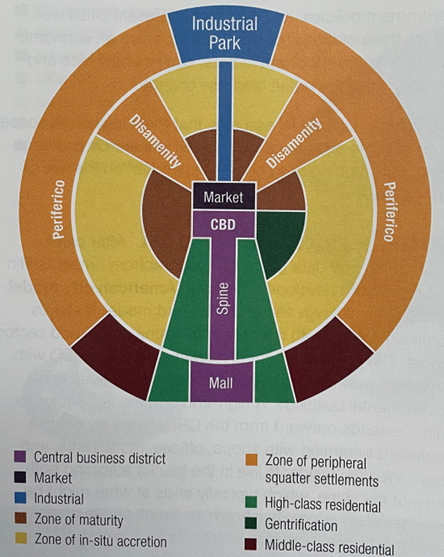
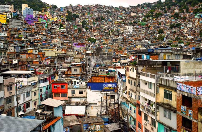
Disamenity Zone:
High poverty urban area in disadvantaged locations (steep slops, flood zones, near rail lines, landfills, or industry). Develop squatter settlements/shantytowns lacking basic infrastructure.
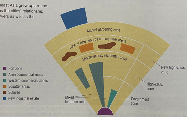
Southeast Asia City Model
SE Asian cities grow around ports. No clearly defined CBD
Shares elements of Burgess concentric zone model
Model was made in 1967, many SE Asian cities now have CBDs.
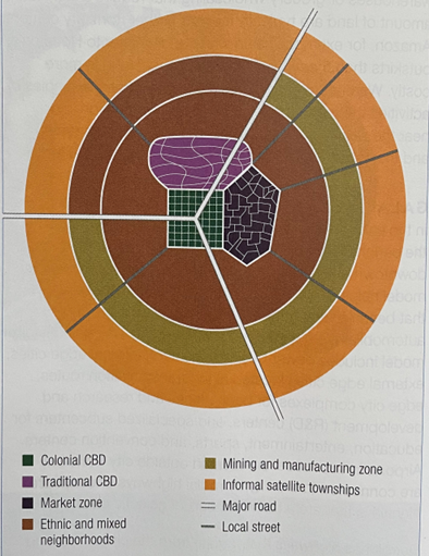
Africa City Model
Shares elements of other models
Colonial CBD: created by colonizers, grid pattern
Traditional CBD: Curbside commerce, one story retail stored.
Market CBD: open air markets
High income neighborhoods and infrastructure in CBDs
Squatter settlements on the outskirts near mining and manufacturing.
---------------------------------------------------------------------
Residential Land Use
Low, Medium, and high density housing.
Varies city by city, and Whitin a city.
US urban areas are less dense than other countries. US cities are newer, other countries are older and the cities develop before advances in transportations.
United States
Urban sprawl happened after widespread use of cars. Cities and suburbs built around roads.
Europe
Cities are built for walking, bicycling, near subways/rails. People can live there without a car.
New York City
Skyscrapers in Manhattan
Most boroughs have mid and low rise buildings
Single family homes in Queens, Brooklyn, the Bronx, and Staten Island.
Average square footage of homes
Australia: 2303 sq feet
Us: 2164 sq feet
Japan: 1023 sq feet
China: 646 sq feet
Culture also affect this. Americans want more privacy (single family homes, backyards, space..
Infilling:
Redevelopment that identifies and develops vacant parcels of land withing previously built areas.
Infrastructure
The attitudes and values of a population, as well as the balance of power within that population, are reflected in the built landscape
Explain how a city’s infrastructure relates to local politics, society, and the environment
The location and quality of a city’s infrastructure directly affects its spatial patterns of economic and social development
Infrastructure:
The many systems and facilities that a country needs in orer to function properly (communication, transportation, sewage, water, electric, etc.)
Well functioning cities need to have well developed infrastructure.
Core countries have infrastructure.
Infrastructure promotes economic and social development
inequality of infrastructure within cities (poorer areas have worse infrastructure).
Examples:
Lagos, Nigeria (6% of houses are on public sewers, poor transportation).
Copenhagen, Denmark, and Amsterdam, Netherlands, (Bicycle transportation, 40% of all trips are on bicycle)
Urban Sustainability
The attitudes and values of a population, as well as the balance of power within that population, are reflected in the built landscape
Identify the different urban design initiatives and practices
Explain the effects of different urban design initiatives and practices
Sustainable design initiatives and zoning practices include mixed-land use, walkability, transportation-oriented development, and smart-growth policies, including New Urbanism, greenbelts, and slow-growth cities
Praise for urban design initiatives include the reduction for sprawl, improved walkability and transportation, improved and diverse housing options, improved livability and promotion of sustainable options. Criticisms include increased housing costs, possible de facto segregation, and the potential loss of historical place or character
Urban Sustainability
Controlling pollution and reducing a city's ecological footprint. Also considers ways to promote economic prosperity and equality. Makes a city more livable.
New Urbanism
School of thought that promotes designing growth to limit the amount of urban sprawl and preserve nature and usable farmland. Increases interactions between people.
Support multiple transit options, preserve historic buildings, respect for local ecology, more parks/open space.
Mixed Land Use
Land is designed for multiple uses such as residential, retail, education, recreation, industry, and office space. Often considers walkability.
Minimizes need to travel outside the area.
Transportation Oriented Development
The creation of dense, walkable, pedestrian-oriented, mixed-use communities centered around or located near a transit station.
Often are pull factors for people to move there.
Smart-Growth Policies
The goal is to create sustainable communities by placing development is convenient locations and designing it to be more efficient and environmentally responsible.
Government can offer financial incentives to builders.
Greenbelts
A ring of parklands, agricultural land, or other types of open space maintained around an urban areas to limit sprawl.
Serves as an urban growth boundary. Helps protect wildlife.
Also gives city resident to connect with nature and enhance their quality of life.
Criticisms
De Facto Segregation
Increased Housing Costs
Redlining
Loss of Historical Sense of Place
Urban Data
The attitudes and values of a population, as well as the balance of power within that population, are reflected in the built landscape.
Explain how qualitative and quantitative data are used to show the causes and effects of geographic change within urban areas
Quantitative data from census and survey data provide information about changes in population composition and size in urban areas
Qualitative data from field studies and narratives provide information about individual attitudes toward urban change
Quantitative Data
Census and survey data provide information about change sin population composition and size in urban areas.
Qualitative Data
Fields studies and narratives provide information about individual attitudes toward urban change.
Unit 7
Unit 7 Notes 5:
World Trade and the Economy
Explain causes and geographic consequences of recent economic changes such as the increase in international trade, deindustrialization, and growing interdependence in the world economy
Complementarity and comparative advantage establish the basis for trade.
Neoliberal policies, including free trade agreements, have created new organizations, spatial connections, and trade relationships, such as the EU, World Trade Organization (WTO), Mercosur, and OPEC, that foster greater globalization.
Government initiatives at all scales may affect economic development, including tariffs.
Global financial crises (e.g., debt crises), international lending agencies (e.g., the International Monetary Fund), and strategies of development (e.g., microlending) demonstrate how different economies have become more closely connected, even interdependent.
World Trade and Economy
Globalization of the world economy. High degree of economic interdependence.
Globalization is expanding the gap between core and periphery countries. Also widening income disparities within a country.
Comparative Advantage
The relative cost advantage a country or organization has to produce certain goods or services for trade.
Ex: If 2 countries can make corn and computers. It does not make sense for the countries to produce both. One will produce corn and one will produce computers.
Complementary Advantage
The mutual trade relationships that exists between two places based on the supply of raw materials and the demand for finished products or services.
Example: US produces apples and exports to Mexico. Mexico produces avocados and exports to US.
Neoliberal Policies
Beliefs that favor free-market capitalism in which trade has no constraints from government. Privatization, deregulation, free trade, etc.
Free trade agreements are an example. These can also be classified as supranational organizations.
World Trade
European Union
Eliminate trade barriers such as tariffs and quotas between countries in Europe.
Mercosur
South American trade agreement. Goals to expand trade, improve transportation, reduce tariffs.
Organization of Petroleum Exporting Countries (OPEC)
Control global oil markets.
World Trade Organization (WTO)
Provide govts with the forum to negotiate trade agreements, settle disputes, and oversee trade rules. Designed to remove obstacles to trade
International Monetary Fund (IMF)
Ensure the stability of international monetary system.
World Bank
Lends money to governments (Epically periphery/semi-periphery)
IMF and WTO are controversial, proponents of free trade argue these organization interfere with free trade.
Government Policies
Tariffs
Taxes on items leaving or entering a country, often used to raise the price of imported goods. Supports locally produced/domestic goods.
Trade Embargos
Policy that can stop flow of critical resources, usually in place for political reasons. (US & Cuba)
International Debt Crisis
Due to global interdependence, if one country experiences financial crisis, that financial crisis is "felt" globally.