

Mass movements - slope processes
Slope processes
Mass movements, Weathering , Erosion
Mass movements
This is the downward movement of rock, soil and debris under the influence of gravity. Mass movements are distinguished from erosional processes because they do not involve transporting media such as water or wind. Various methods have been used to classify these mass movements.
Types of mass movements
A. Slow movements
Soil creep
This takes place at a rate of less than 1cm per year.
Unlike other processes, this takes place continuously.
Occurs on slopes that are steeper than 60
Its most visible effect is the bending of trees and telegraphic poles downslope, as shown below:
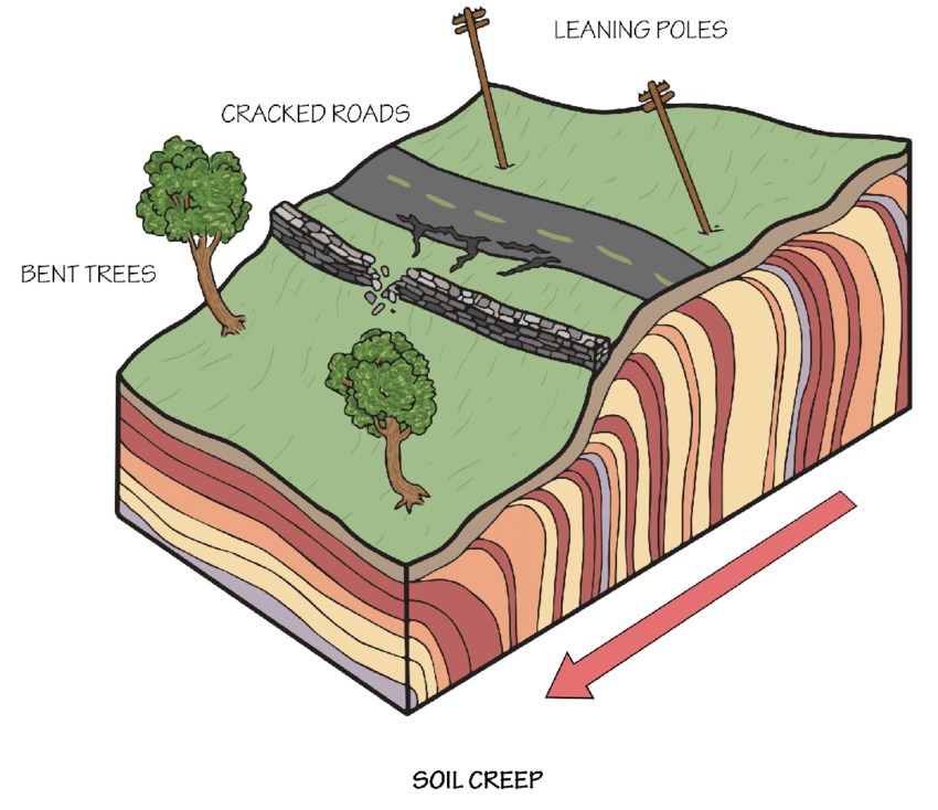
There are two causes of soil creep.
One way is whereby clay minerals absorb water and expand in the process. The expansion that takes place occurs at right angles to the direction of the slope. However, when the minerals contract due to drying, they don’t fall back to their original position but rather to a site that is downslope of the original position due to gravity.
The other way occurs in cold regions where the freezing of saturated regolith has the same effect as the one outlined above. When water-saturated particles freeze, they increase in volume by 9% due to the presence of ice. The process of expansion is perpendicular to the direction of the slope. When the identical particles contract during thawing, they also return to a newer site that is further downslope of the original position
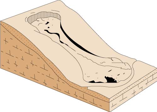
Solifluction
The term comes from the Greek term meaning ‘soil flow’
It occurs at a faster rate than soil creep, i.e. at 5cm to 1m per year
It leaves behind tongue-like solifluction lobes at the bottom of the slope as shown below:
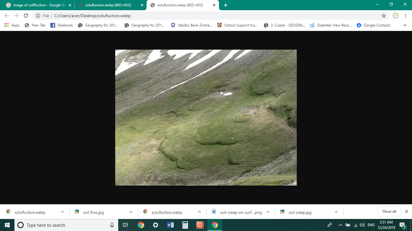
Solifluction occurs mainly in cold regions where vegetation is limited. During the winter season, all the regolith becomes frozen. During the summer season, only the top part of the regolith melts, while the underlying sub-terrain remains fully frozen. Since ET rates are low and the fact that melt water cannot percolate further into the frozen soil, the top part of the soil becomes saturated with water, and so begins to flow downhill as solifluction.
B. The Flow movements
These occur when slope materials have a higher content of fine particles almost 35% by weight. They are generally much faster than the slow movements. The slopes can be gentle, but they are more common on slopes that are more than 100.
Earthflows
These are water-saturated and viscous masses of earth that can move downhill for 1km in just a few hours. They vary in volume from a few cubic up to a million cubic meters.
This movement occurs in humid regions where the water-saturated regolith occurring on relatively steep slopes is triggered into motion by any of the following triggering mechanisms:
Undercutting of steep soil mantled slopes by stream erosion.
The existence of feeder springs which provide a continuous supply of water that eventually saturates the soil.
The occurrence of heavy rainfall that may eventually saturate the soil triggering movement.
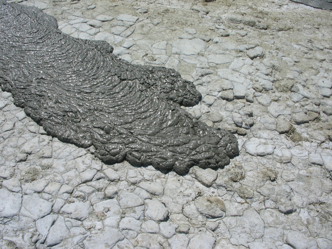
Mudflows
These are more rapid, less viscous and flow on much lower slope ends than earth flows. They, therefore, travel longer distances than the earth flows due to their low viscosity.
Mudflows occur in several situations:
Heavy rainfall may flush out debris that moves downhill into a valley where the debris becomes mixed with water to form a thick paste that then moves along the valley as an ordinary mudflow.
Freshly fallen volcanic ash becomes mixed with heavy falling rainwater or water from snow melted by the volcanic heat to form a hazardous Lahar:
C. Rapid Movements
Landslides
Also known as slumps, these are rapid sliding of masses of earth, rock material or regolith. Landslides move ‘en masse’ i.e., the mass of land that slides on does not suffer internal derangement of particles whereas in the earth flow or the mud flows, there is internal derangement of the particles.
There are two types of landslides: -
Planar Landslides- in this case, the material sliding leaves behind a planar rupture surface as shown below.
Rotational Landslides- in this case, the material leaves behind a curved ruptured surface, as shown below.
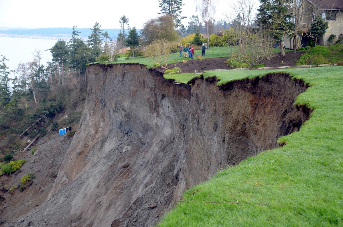


What triggers a landslide?
Lubrication by water plays an important role because the water reduces the original cohesion between two different layers. For example, landslides become quite common where clay soils overlie sand soils.
Over steepening of the slope is due to either road construction or extreme erosion of the outer bank of a meander.
Overloading of slopes by the coming in of extra material from either volcanic eruptions or excess rainfall
Conditions favouring landslides may exist for a long time until a triggering mechanism (such as an earthquake) gives the movement the required impetus.
D. Very Rapid Movements
Rock falls
This is the free-falling of material along a steep slope greater than 400 or along a cliff.
Materials involved could be as little as sand grains or as large as a city block.
The falling blocks disintegrate while collapsing producing much rubble as they fall. The rubble is usually strewn at the base of the slope.
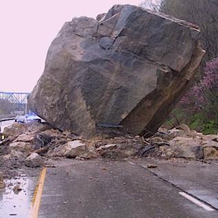
What could trigger a rock fall?
Earthquakes could loosen precariously balanced rocks.
Extreme physical or chemical weathering dislodges large blocks from the mother rock that then rolls down the slope.
Wave erosion may undercut a cliff at its foot, which triggers the overhanging block to rock fall.
Excessive rainfall can also provide enough separation of rock boulders that previously were balanced.
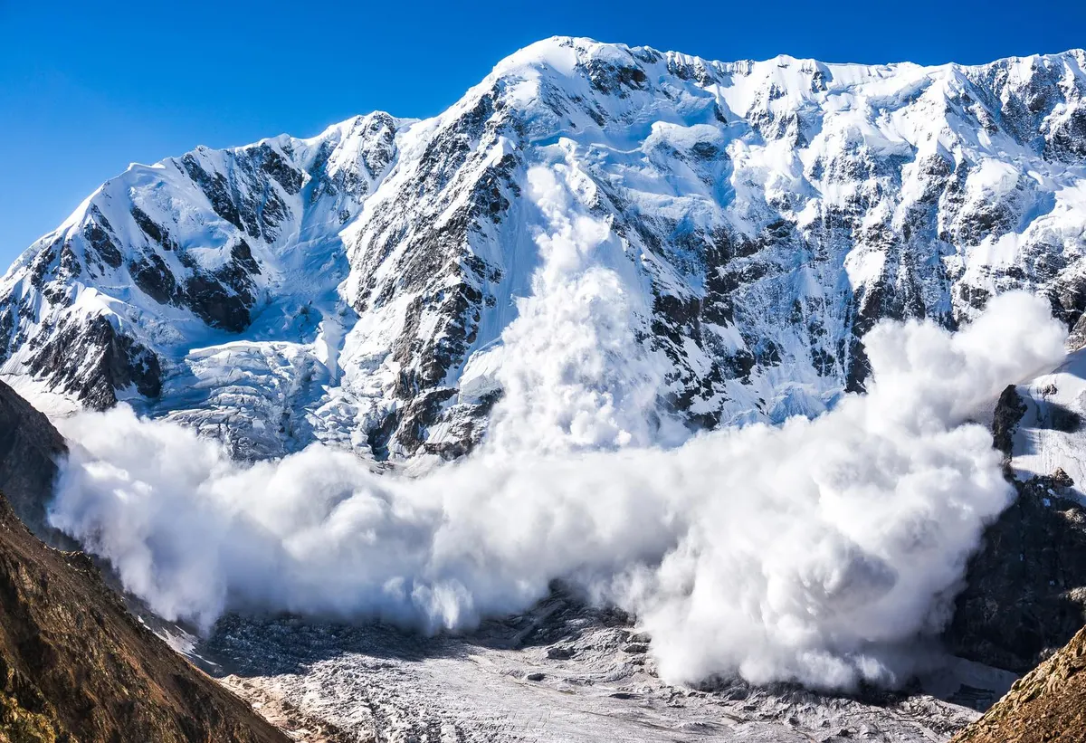
Avalanches
This is the sudden downhill movement of rock, snow and ice. This occurs when the material has reached a threshold mass enough to overcome the frictional force holding the fabric from moving, allowing the material to flow at incredible speeds of more than 40-60km/hr.!
What causes avalanches?
Heavy snowfall that adds extra weight to the already existing ice mass
Deforestation of forests may reduce slope stability causing ice to glide downhill.
Vibrations caused earthquakes, nearby traffic, and man-made explosions to offset a hazardous avalanche or during preparation for ski paths.
Very long, cold, and dry winters may create an earlier snow mass. However, during spring, new snow may accumulate above the old snow. The fresh snow tends to slide above the old snow.
Overland flow on slopes
Overland flow is the unconcentrated movement of water as sheet wash or concentrated into channels such as rills. It is unconcentrated that water does not flow into any distinct channels, such as rills or pipes; rather, it just flows unconcentrated on the surface. Sheet wash is a result of Overland flow. Sheet wash only operates within a few inches deep from the surface, collecting soil in the path. Overland flow occurs by:
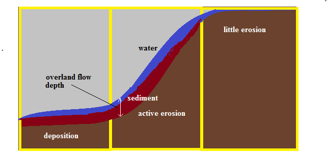
The Hortonian model of Overland flow
This occurs on slopes when rainwater fails to infiltrate the soil; thus, in doing so flows along the surface as a thin layer of dirt. It is more pronounced in arid regions where soils are thin and without vegetation, and the underlying rocks are usually impermeable. The erosive power of water must overcome the shear resistance of soil, and once it is overcome, the soil is moved.
On the convex upper slope (gentle), overland flow is less pronounced and, therefore less erosion as soil resistance is more excellent than the flowing water. Also, water is given time to infiltrate as the surface is relatively flat.
The middle part of the slopes is where active erosion is present due to the built strength of water from the upslope. Water flow is fast and is concentrated into tiny channels called rills a few millimeters deep.
The concave gentler unit is primarily deposition of all material.
 Hortaninan Overland flow
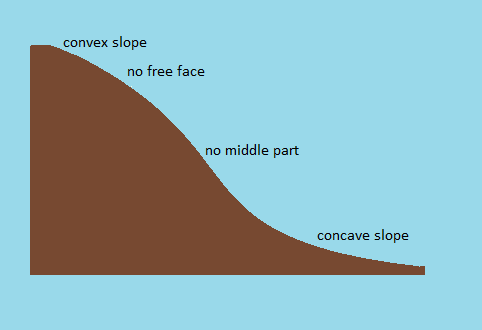
Slope forms
The various slope-forming processes studied above produce various slope forms in different areas of the world. There are several factors which would eventually determine which slope element dominate in an area, but the basic slope forms of a hillside should consist of the following: -
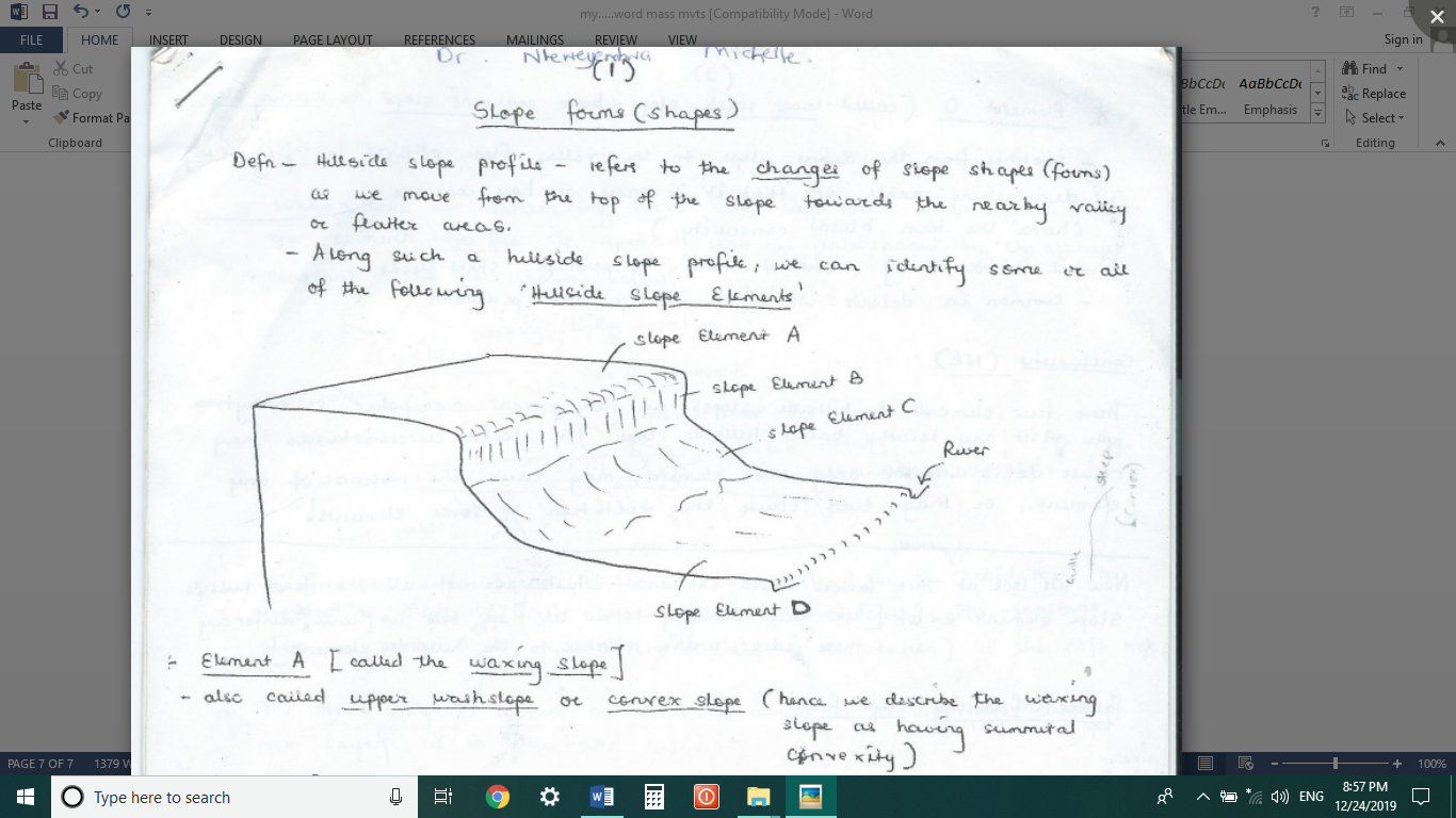
Element A
It is called the waxing slope, the upper wash slope or the convex slope; hence the upper slope is described as having summital convexity.
The waxing slope tends to be convex in profile due to the control of curvilinear joints in granite or the erosion of material from the summit by overland flow.
Element B
It is called the free face, cliff, derivation slope or gravity slope. The slope is vertical to near vertical. It is usually a bare rock from which weathered material is derived, hence the derivation slope. Any of the following denudation processes produces it:-
Wave erosional action on hard rocks
River erosion undercuts a slope on the outer bank of a meander,
Hard rocks outcrop on valley sides where they resist erosion compared to the softer rocks, as shown below:
Element C
It is also called constant slope, debris slope, rectilinear slope or scree slope. It is a slope made of material weathered and mass wasted from the cliff face that builds at the base of the slope. The angle of the debris slope is determined by the angle of repose of the materials building it up; the coarser the particles, the higher the angle and the finer the particles, the lower the angle because the latter are further moved by gravity compared to the former.
Element D
It is also called the waning slope, the pediment slope or the lower wash slope. It stretches from the debris slope to the valley, with its angle progressively decreasing, becoming more concave in outline, hence the term basal concavity. It is formed by active overland flow erosion at the base of the slope as predicted by Horton (1945).
Conclusion: these slope forms are only sometimes present whenever someone visits any hillside slope. The local circumstances may cause the dominance of one element, and may even cause the repetition of one element.
Factors influencing slope form and stability
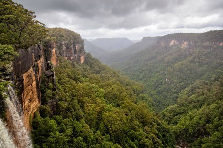
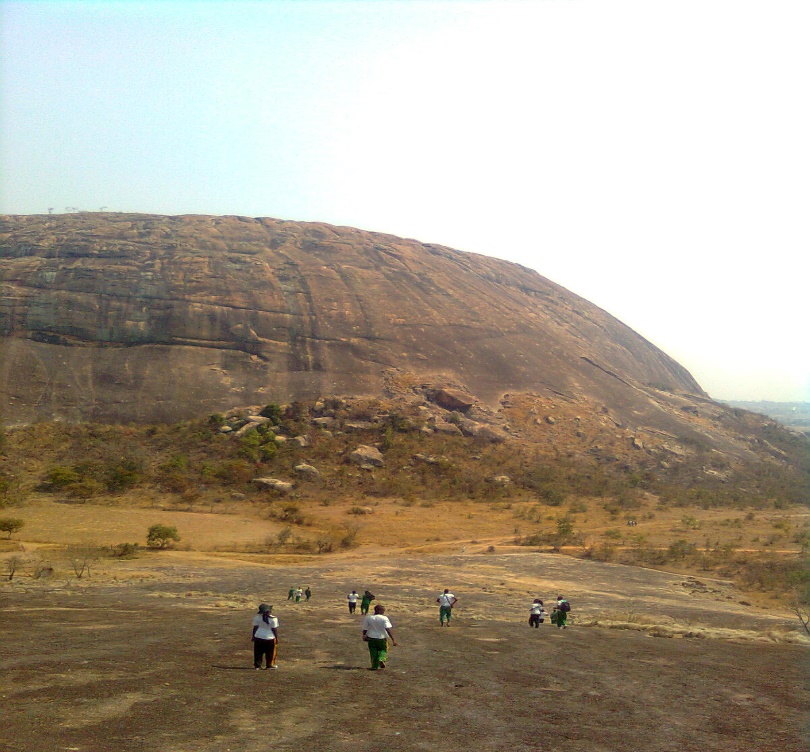
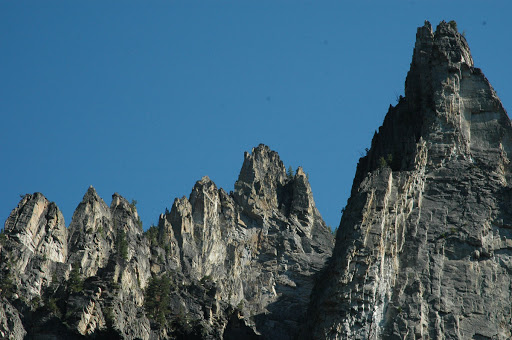
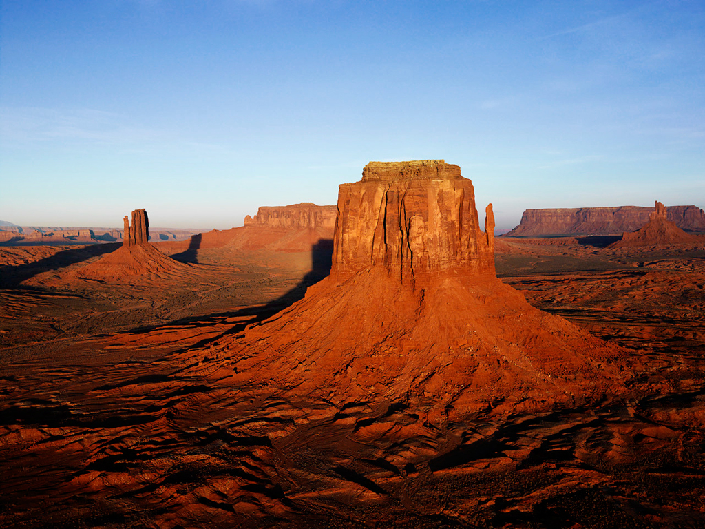
Rock type
Hard and coherent rock such as granite can resist all the slope-forming processes of weathering, erosion or mass wasting.
Such rocks are therefore able to form the convex slope, the free face, the debris slope and the pediment slope as shown in the photography below:
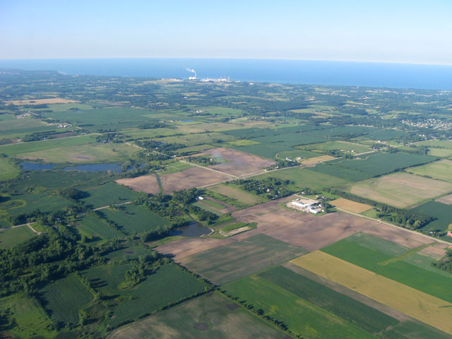
However, unconsolidated material such as sandstones or ordinary soils are more vulnerable to erosional and mass wasting processes (soil creep & mudflows) and so produce gentle slope profiles that are dominated by submittal convexity and basal concavity, forming the famous undulating terrains of Zimbabwean plateaux.
Rock structure
Where there are alternating bands of hard and soft rocks along a slope profile, the free face element is repeated along the hillside profile, inter-spaced by the debris slope.
The free face exists because of its general resistance to denudation processes of weathering, erosion and mass wasting. However, the debris slope is formed due to the rapid retreat of the softer rocker interspacing the hard rock.
The other way to look at the influence of rock structure is to imagine a situation where rock strata dip in different directions to the slope, as shown below.
![]()
![]()
![]()
![]()
![]()


![]()
![]()
![]()
![]()


![]()
![]()
![]()
In the first scenario, the rock strata dip away from the hillside slope and is, therefore, more resistant to denudation processes. The hillside slope is, therefore, most likely to develop a free face with the waxing slope at the summit.
In the other scenario, the rock strata dip parallel to the hillside slope. Such strata is more vulnerable to denudation, and so the hillside slope is quickly reduced to a debris slope and eventually to a pediment slope. If it still exists, the free face occurs at a low angle.
![]()
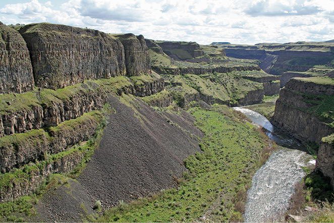
Geological history of the terrain
Recent earth movements such as the folding processes that have produced the ‘young fold mountains’ of the Alpine-Himalayan series and the Andes, have produced a youthful landscape.
Such a landscape consists of deeply incised valleys with steep free faces. The individual free faces are separated by waxing slopes. This means in a youthful terrain; the pediment and the debris slope are basically absent.
Old landscapes such as the old fold mountains of Scottish Highlands, the Appalachian Mountains have had a longer geological time to allow the scarp retreat processes (weathering, erosion & mass wasting) to work on the free faces to produce the debris and the pediment slopes.
The diagram shows that an old landscape consists of rolling Pedi-plains separated by limited waxing slopes.
Climate
The climate significanttant factor influencing slope form because it determines the type of weathering (be it physical or chemical), it determines the depth of regolith from deep weathering and also influences the type of mass movement.
Humid climates such as the equatorial and the savannah, produce well rounded landscapes with gentle slope profiles.
This is because of the dominance of chemical weathering processes which produce a thicker regolith that masks most of the parent rocks. Besides the thicker regolith layer, the dominant mass movement processes are the flow type which also tend to produce gentle slope profiles. As shown in the diagram, the free faces are basically absent in the humid tropics, there is the dominance of the summital convexity and basal concavity.
On the other hand, arid and semi-arid climates produce mostly all the four elements of the hillside slope model:
The waxing slope, free face, the debris slope and the extensive pediment are all present because of the dominance of mechanical weathering which produces a rough terrain. The free faces and the bare rocks are because of the limited chemical weathering and so there is very little regolith to mask the rocks.