Using hazard maps to identify Geological Hazard
Geological hazard maps are scientific tools developed and created by scientist that shows a potentially dangerous area or locality in terms of geological aspect.
There are two government agencies in charge of creating geological hazard maps specifically the Philippine Institute of Volcanology and Seismology (DOST-PHILVOCS) and Mines and Geoscience Bureau (DOST-MGB).
PHILVOCS is the government agency mandated to study the different kinds and types of volcanoes in the Philippines and earthquakes.
MGB is the lead agency tasked to study land area rich with natural minerals and the different types of land thereby they study land areas prone to landslide.
Geological hazard maps display areas at risk from earthquakes, volcanic eruptions, and landslides. They include information on the size of affected areas, the number of families and structures impacted, and total households, providing an estimate of affected families. These maps are color-coded for easy reading and understanding, and they help identify locations most likely to be impacted by these hazards.
EXAMPLES OF HAZARD MAPS:
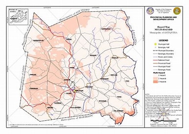
Summary of Geological Hazard Maps
Geological hazard maps are essential tools for mitigating the adverse effects of hazards such as ground shaking, ground rupture, and liquefaction. They help communities identify risk-prone areas and make informed decisions about construction and safety. If relocation is not possible, retrofitting structures to withstand hazards is recommended. However, the best approach is to avoid building in high-risk areas. These maps are considered "living documents" as they are regularly updated to reflect changes in the community.
Key Points
Purpose: Minimize risks and damage caused by geological hazards.
Types of Hazards: Ground shaking, rupture, liquefaction, etc.
Usefulness:
Guide safer construction practices or relocation.
Highlight areas unsuitable for building structures.
Liquefaction: Occurs when soil turns weak and water-like due to shaking.
Dynamic Nature: Maps are regularly revised and updated for accuracy.