Geography 3.1 - Tongariro Volcanic Geographic Environment
Demonstrate comprehensive understanding of how interacting processes shape a New Zealand geographic environment
This achievement standard will focus on the Tongariro volcanic geographic environment (TVGE).
What is a Geographic Environment?
A geographic environment is a location on the Earth where a number of natural processes operate to shape and change its features. In the Tongariro volcanic region, these include:
Internal Processes → these originate beneath the Earth’s crust and are driven by convection currents in the mantle. These cause folding, faulting, volcanism and the associated earthquakes.
Volcanism
External Processes → these act upon the surface of the Earth and are largely driven by climate.
Climatic processes
Soil development
Vegetation succession
Denudation
Features of the Tongariro volcanic region shaped by these processes include:
Mountains (Ruapehu, Ngauruhoe, Tongariro, Pihanga, Pukeonake)
Lakes (Blue, Emerald, Tama, Rotoaira)
Ruapehu’s Crater Lake
Craters (North, Red, Central)
Ketetahi Springs
Harsh alpine climate
Poor pumice soils
Hardy shrubs and tussock
An example of how the above processes have shaped the features of the environment can be seen at Mt. Ruapehu. Volcanism builds up a mountain with highly erodible slopes in a moist, temperate climate. Running water provided by rainfall carves deep, radial grooves on the mountain slopes. Erosion and mass movement remove materials from the cone and deposit them on the ring plain. Vegetation succession and soil development processes on the cone are periodically halted by volcanism and denudation. Vegetation may help to protect the land against denudation.
Internal Processes (Plate Tectonics and Volcanism)
The peaks of Tongariro, Ngauruhoe and Ruapehu the dominant features of the Tongariro volcanic region. In order to understand the reason for their location and growth, we need to understand the processes of volcanism and plate tectonics.
Plate Tectonics
Across the globe volcanoes and mountains form a distinct pattern on the Earth’s surface:
All patterns result from some process. The plate tectonic process explains large-scale movements of the Earth’s outer rigid crust. The crust is broken into various slabs (plates) of differing sizes. Tectonic plates are up to 60km thick and slowly move. They can move apart (diverge), collide (converge) or slide past each other (transform). The reasons for this activity lie below the surface where heat energy is being released by our cooling planet:
At the centre of the Earth is a solid inner core of iron and nickel where the temperature can reach 5000 degrees Celsius. Surrounding this is a cooler zone, the mantle, where temperature are 1300-1600 degrees Celsius. The outer part of the mantle (the asthenosphere) contains mineral so hot they can flow - however the weight of the crust above them prevents this. Instead, they ooze slowly by the movement of convection currents. These occur due to heat energy rising from the core to the crust, where cooling will occur. The minerals will then sink, dragging the tectonic plate above with it.
There are two different types of crust:
Oceanic crust is 5-10km thick and made of heavy, dark, volcanic rock called basalt. Basalt is rich in iron and magnesium, with around 45% silica. It is a young rock formed when molten mantle squeezes out from between crustal plates.
Continental crust is up to 35km thick and made up of buoyant, light-coloured rock and contains a lot of silica and aluminium. Granite is the most common rock in continental crust. Continental rocks are very old as they have formed from sediments that are added to their edges. The continental crust floats on the mantle.
Due to the difference in density, it is not possible for a piece of continental crust to sink deeply beneath the sea. However, heavy oceanic plates can sink beneath continental plates. This is called subduction.
There are three types of crustal plate movement, which result in three types of plate margins:
Convergent (or destructive, collision) margins occur where plates crash into each other
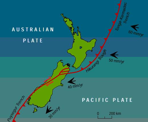
When continental and oceanic plates collide, the heavier oceanic plate is subducted under the buoyant continental plate, leaving an ocean trench on the surface (e.g. the Kermadec Trench). As the oceanic plate descends, it encounters increasing heat, pressure and friction and begins to melt and be re-absorbed into the mantle. Pockets of magma develop along the descending plate margin where the friction is also causing earthquakes. The volcanoes in the Tongariro volcanic region are a result of subduction.
Sometimes two continental plates will collide. The edges will crumple up to form mountain ranges (e.g. the Himalayas).
Divergent (or constructive) margins occur when plates move away from each other
As plates separate they leave a gap on the surface. Magma from the mantle oozes to the surface and forms a line of volcanoes along mid-ocean ridges (e.g. the mid-Atlantic Ridge). As the mantle rocks solidify, they stick to the edges of the divergent plates, becoming new basaltic crust. This process is called seafloor spreading.
Transform margins occur where plates are sliding past each other
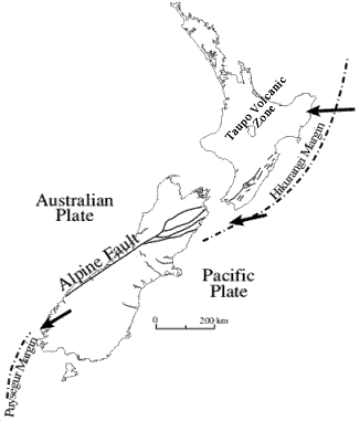
At these margins, crust is neither created nor destroyed. Whener plates crack or move suddenly, the energy is released as an earthquake (e.g. the Alpine Fault).
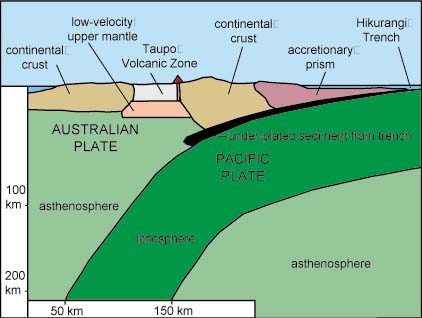
New Zealand sits on the margin of the Pacific and Australian plates, where the heavier Pacific plate has been subducting beneath the lighter Australian plate for the last 15-20 million years. The continental crust of the Australian plate has been squeezed and compressed along the plate margin, resulting in many of the the iconic geographic features, such as volcanoes, folded and folded mountain chains, and earthquakes. As the Pacific plate descends, friction has made the continental rock crack and buckle and in places magma has risen to form volcanoes. The Tongariro volcanic region is part of the large Taupo volcanic centre, which stretches from Mt. Ruapehu to the Bay of Plenty. This is an active rift (the Taupo Graben) which has developed as a result of blocks of land dropping between parallel faults. As a result of this faulting, the crust in this area has thinned and continued to stretch and allow magma to come to the surface, forming volcanoes.
Maps and diagrams
Volcanism
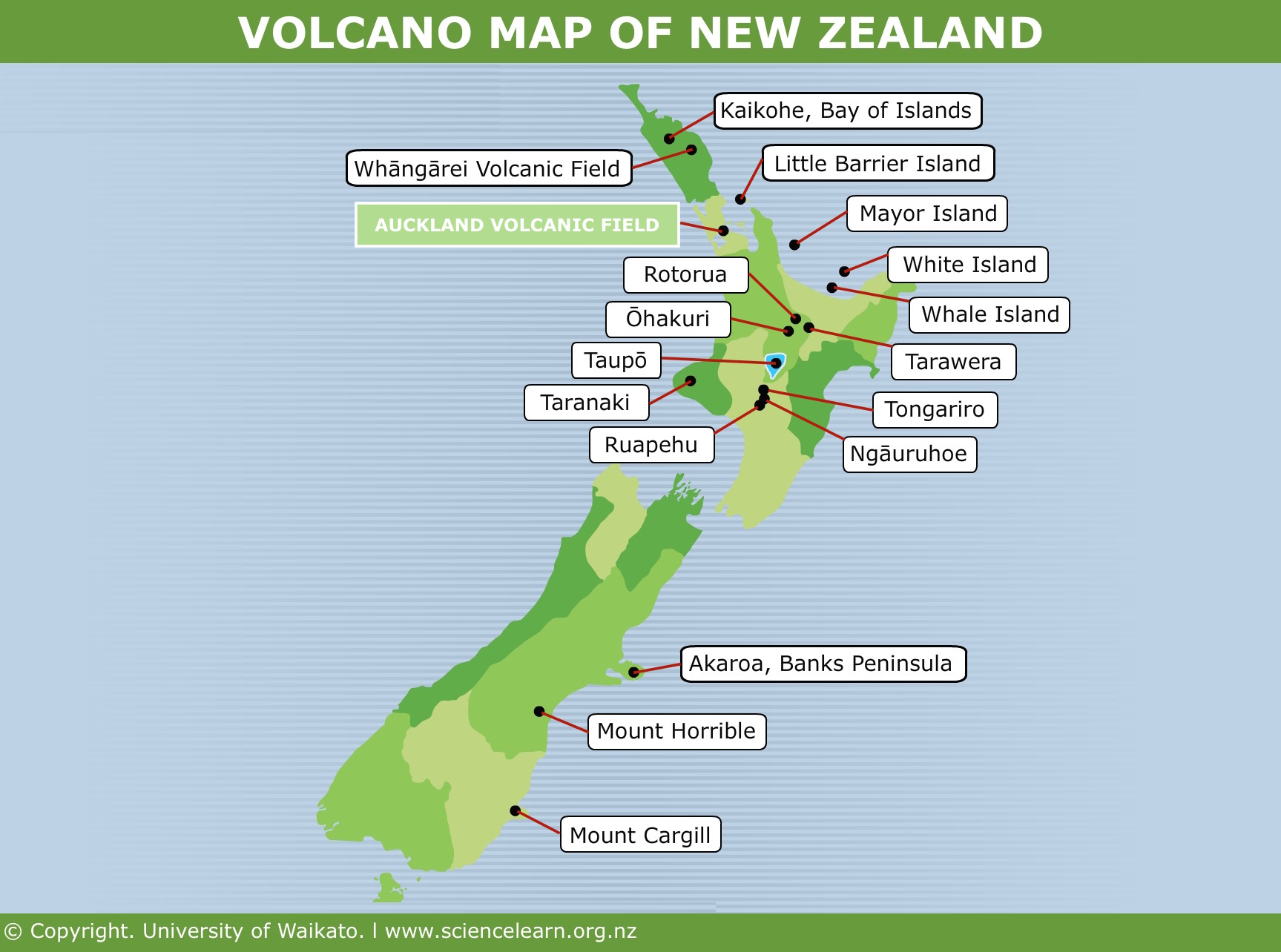
Most New Zealanders realise that earthquakes are a major hazard to the nation. Far fewer realise our volcanoes are amongst the world’s most destructive. The North Island has seven volcanically active zones, a number of which are capable of eruptions of devastating proportions. The majority of the North Island’s volcanoes lie is a curved arc stretching from Mt. Ruapehu to Raoul Island. These volcanoes are a result of subduction and rifting. Meanwhile, the volcanoes of Auckland and Northland are the result of a hot spot.
New Zealand’s active volcanoes are all located in the North Island, and relate to the subduction of the Pacific plate below. Those in the central North Island originate in shallow magma chambers, while those in Auckland and Northland originate deep below the surface. The Taupo volcanic zone lies in NE-SW direction and is about 240km long, parallel to the subduction zone. Within this zone have been some of the most violent eruptions in the world.
Volcanoes are the result of a unique phenomenon that produces a huge volume and variety of material and that takes on a range of shapes. Raw material and shape depends on the depth of the magma at the source and the presence of elements such as water when the volcano erupts.
Magma is the raw material of volcanoes. It is made of varying proportions of hot molten gases, rocks and solids. Some magma is viscous (thick and sticky) and the eruptions are violent. Some magma is non-viscous (thin and runny) and erupts quietly. The amount of silica influences the viscosity. There are three types of magma:
Basic magma forms at great depths, making it hot, non-viscous, rich in iron and low in silica (<53%). It does not trap many gases. When it erupts, the lava flows easily and travels a long way before solidifying. These lava flows build low, wide volcanoes (e.g. Rangitoto Island). These eruptions are typically quiet and affect small areas. Basalt rock is formed when the lava solidifies, so these may be referred to as basaltic eruptions.
Acidic magma forms in shallow magma chambers, close to the surface. This means it is relatively cool, viscous and has a high silica content (>67%). It has a high gas content. When it erupts, the lava solidifies quickly and cannot travel far. Sometimes acidic magma is extruded quietly to build small, humpy lava domes (e.g. Mayor Island). Occasionally it erupts explosively as trapped gases are suddenly released (e.g. the Taupo volcano). These explosive eruptions blast out large calderas and spread pyroclastic debris over vast areas. When the lava solidifies, rhyolite rock is formed, so these may be referred to as rhyolite eruptions.
Intermediate magma is between acidic and basic magma. These have 53-67% silica and form andesite rock. These eruptions form composite cones (e.g. Mt. Ruapehu).
Volcanic Eruptions occur when magma rises to the surface of the Earth. As magma is buoyant and contains gases that are compressed by the weight of the crust above, the pressure will build up and the magma will seek a path to the surface. If the continental crust is fractured, magma can rise to the surface. Eruptions can occur in a number of ways
Lava is the molten rock formed when magma flows onto the surface, It has the same minerals as the magma that created it, but lacks gas and water as these are released during an eruption. As it cools, lava loses its ability to flow and solidifies to form volcanic (igneous) rocks.
Poisonous Gases and Steam are released during a volcanic eruption. During the 1995-96 Ruapehu erptu=ion a large cloud of gas extended form the volcano as far away as Christchurch. Residents near the volcano were warned they may need to evacuate if the gases became too dangerous. In the end, this was not necessary. The violence of an eruption is related to the viscosity of the magma; the harder it is for gases to escape, the more violent the eruption will be when the gas is eventually released.
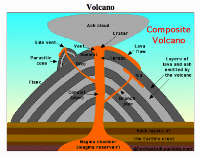
Subterranean Deposits occur when magma wells up but does not reach the surface. The magma can solidify is large underground chambers call batholiths and laccoliths. Granite is formed this way. As the magma builds up underground, surface rocks may dome. Dykes are formed when magma solidifies in a vertical crack in the wall of a volcano. Sills are formed when magma solidifies between horizontal rock layers. Magma also solidifies in a volcano’s pipe, where it will remain until the next eruption. When magma solidifies below the surface, it forms a dense, hard rock which can act as a cork to prevent further magma from rising. As surface materials are eroded away, these harder subterranean rocks may be exposed on the surface.
Pyroclastic Materials (fire-broken) are fragments of solid lava ejected from volcanoes so violently that they become airborne. Fragments can range in size from ash (<2mm) to boulders the size of houses. Ash eruptions are the most common type in the Tongariro volcanic region. As gas bubbles rise to the surface during an eruption, they may be covered with skins of molten magma. Upon reaching the surface, the gas expands and explodes, ripping the skins to shreds and tossing them into the air as clouds of ash. This coats the land around and downwind the vent with tephra (volcanic debris that falls to the ground as ash showers). Simultaneously heavier pyroclastic materials and gases may spill out of the crater and boil rapidly don the slopes in swirling nuée ardente (ash avalanches). These deposit debris in wide sheets up to two kilometres away from the vent, quickly and silently.
Volcanism in the Central North Island
As it descends into the asthenosphere, the Pacific plate drags down surface materials from the ocean floor - rocks, shells, gases and water. Heat and friction melts this buoyant material, which is now trapped in magma chambers close to the surface. The crust is very thin above these magma chambers. The Pacific plate is descending at a rate of about 5cm/yr. It buckles and cracks the leading edge of the overlying Australian plate, creating ranges of hills parallel to the plate margin.
The Taupo Volcanic Zone is long and narrow and the reason for this is a long trench call the Taupo Graben under the surface. This is a rift valley. In the Taupo volcanic zone, the continental crust is arched upwards in a long NE-SW upfold. The upthrust land stretched and splintered along faultlines in the fold. Then, land either side of the upfold moved further apart and the land in the centre dropped down to form the Taupo Graben. Magma welled up through the thin, fractured crust to create chain of volcanoes in the rift valley. Over time, the volcanoes have filled the graben with erupted materials and turned the trench into a volcanic plateau. Volcanic debris under the surface is now up to 3.5km thick. The weight of these volcanic deposits depresses the valley floor further. After the Kawerau earthquake of 1987, some northern parts of the valley dropped by a metre.
The Pacific plate is sinking below the Australian plate here, but not at a constant depth. The continental crust is thinnest in the northern part of the graben and thickest in the south. This affects:
The type of magma produced (acidic, basic, intermediate);
The way volcanoes in this zone erupt.
All three types of magma chamber are found here:
The Tongariro volcanic region lies over a chamber of intermediate magma which has erupted onto the surface over at least 2 million years to create today’s landscape. Most features are related to the current NE-SW plate boundary. However, three small hills (Pīhanga, Tīhia, Kākakaramea) lie in an E-W direction in the north of the Tongariro volcanic region. These hills are extinct andesite cones that formed when a plate boundary lay here. When the plate boundary shifted, another chain of volcanoes developed due to fault lines in the southern part of the Taupo Graben. These are also due to andesitic volcanoes.
Tongariro is a region of strong contrasts. Bubbling hot springs, active craters and glaciated volcanic cones are key features.
Composite Cones → Ruapehu, Tongariro and Ngauruhoe are large andesitic volcanoes >1900m above sea level. Andesite eruptions build layered, composite volcanic cones. Dominant features such as the composite cones form in locations where cracks or faults allow magma to reach the surface.
During explosive eruptions, heavier pyroclastic materials heap up around vents. During quieter period, lava wells out of vents and flows away, solidifying in long tongues down the slope. Lava seldom flows more than one or two kilometres from the vent so it provides th skeleton of the mountain.
Andesite eruptions tend to be powerful and continue over a long period of tie. Pyroclastic materials are rapidly eroded but lava remains as it is more resistant to the elements. For example, the Pinnacle Range on Ruapehu began as a valley lava flow but turned into a ridge as softer tephra deposits on the valley walls eroded away.
Less violent eruptions over a shorter period have built smaller cones like Pukeōnake (140m tall). This scoria cone was built by fire-fountaining. This occurs when frothy, gas-rich lava cools in flight from the volcano, and forms scoria rock. This rock builds up as a cone around the vent. Pukeōnake formed 20-25,000 years ago over a fault line west of Tongariro.
Sills and Dykes → Magma often rises but is unable to reach the surface. It will instead cool and harden in cracks below the surface. Over times, erosion can reveal these features. This can be seen at Red Crater, where magma welled up through a crack and sank again without reaching the surface.
Thermal Features → Magma can cool beneath the surface for hundred or thousands of years, Escaping gases heat the nearby rock which in turn heats ground water and generates steam. As hot water is less dense than cold water, it rises to the surface along fault lines, forming thermal features
Hot Springs contain superheated water which is rich in minerals;
Geysers occur when hot water and steam bubble up through soil;
Fumaroles are vents emitting hot volcanic gases.
The most notable thermal feature in the Tongariro volcanic region is the Ketetahi Springs, located about 1400m above sea level in the northern slopes of North Crater. Activity is concentrated along the branches of the Mangatipua Stream. There are more than 40 fumaroles, as well and numerous boiling springs and bubbling mud pools. Hot, acidic springwater here creates an array of colours from brown, orange and red to purple, white and green.
Cold Springs → There are numerous cold springs on the slopes of Ruapehu and Tongariro. The source of these springs is rainwater, but their chemical composition reflects the surrounding andesite rock. These springs are similar to the hot springs in their acidity and silicate content. The main difference is the lack of a nearby heat source.
Soda Springs seep to the surface at the head of the Mangatepopo Stream. Thes area is coloured golden by the breakdown of volcanic ash and the water appears to bubble and sparkle due to dissolved gas.
Silica Springs and Rapids from the base of an andesite lava flow create a creamy-white deposit on the land and rockas of the Waikane Stream, These deposits are up to 3cm thick in places.
Fault Lines → Volcanoes and faults are closely linked. A long fault line runs along the western flank of Tongariro, and a further small fault crosses the floor of North Crater. MOvement on these faults is known to have taken place after the Taupo eruption of 232AD, after the ash accumulation.
Explosion Craters → These form when superheating magma comes into contact with groundwater and converts it to steam, blasting away the ground above. The 7 Tama Lakes are explosion craters that formed 10,000 years ago on the saddle between Ngauruhoe and Ruapehu. The Emerald Lakes on Tongariro are another example.
Mount Tongariro
Mount Tongariro’s complex set of craters and cones look like a sprawling range of hills from the Desert Road but are actually a very large volcanic system. The barren, moon-like landscape, steaming fumaroles and vibrant Emerald Lakes draw thousand every year to complete the famous Tongariro Crossing. The multiple cones contain 60 cubic kilometres of erupted material and have been built over just 275,000 years. Volcanic activity continues to this day.
Profile of Tongariro
Summit is 1964m above sea level
Over 13km long and 18km wide
Extends from the shores of Lake Rotoaira to Tama Saddles on the south side of Ngauruhoe.
Multiple cones and overlapping craters
Glaciation has changed early volcanic landscape
Craters and lava flows in NE-SW alignment.
The oldest dated rocks of the Tongariro complex were ejected around 270,000 years ago. By 65,000 years ago, six cones and vents had developed:
Tongariro summit
North Crater
Blue Lake
Pukekaikiore
Vents linked to lava flows down Oturere Valley
Eleven further cones and vents have developed over the last 15,000 years including Red Crater (thought to have been active as recently as the 1800s).
Ngauruhoe is the youngest vent of Tongariro, and begin forming just 2,500 years ago. As it is so young, Ngauruhoe shows few signs of erosion and has a near-perfect cone. Although often considered a mountain in its own right, Ngauruhoe is a vent of Tongariro. In the 20th century, Ngauruhoe was considered the most active volcano in New Zealand, due to frequent eruptions no more than 9 years apart. It erupted over 60 times between 1839 and 1975, including four lava flows. It has been dormant since 1975.
Mount Ruapehu
Ruapehu is the largest of the andesite volcanoes in the Tongariro volcanic region. Vegetated flanks, rugged peaks, and show fields are what we notice about Ruapehu today. These recent features are the results of climate processes and erosion. Beneath lies a much older history of successive eruptions, massive lahars, lava, and pyroclastic flows.
Profile of Ruapehu
Summit is 2979m above sea level (highest point in the North Island)
Crater Lake
8 glaciers
At least 6 craters
Extends from Tama Saddle to Ohakune
One of the most active composite volcanoes in the world
Ruapehu has a composite cone built up by repeated eruptions over time. There have probably been volcanoes on the site of Ruapehu for 2 million years, but what i visible today developed much more recently. Around 250,000 years ago Ruapehu was building up around a single vent. It looked similar to Ngauruhoe today. It is now smaller and more sprawling than it was in the past. Over the past 250,000 years, Ruapehu has had periods of:
Active cone building separated by quiet periods when the cone has almost eroded away;
Magma eruption from one vent or others at different times;
Lava flows extending in thick tongues down the slope;
Pyroclastic eruptions which heaped up loose debris on steep slopes;
Lahars and debris avalanches which removed loose debris;
Glaciation during the last Ice Age (around 18,000 years ago).
All of these processes have varied in magnitude and frequency over time. Ruapehu is currently in an active phase, with the active vent beneath Crater Lake.
Although Ruapehu is a composite cone like Tongariro and Ngauruhoe, two important differences make it more dangerous: the Crater Lake and glaciers/snowfields. Surface water changes the way a volcano erupts as the hot magma will quickly cool. Gases in the magma will explode more violently, steam clouds will swirl and boiling mud and ash will shower the summit area. When the mix of hot water, ash and debris hit the snow and ice fields, rapid melting occurs and may lead to mudflows called lahars.
Lahars are often set off by volcanic eruptions. A lahar is a river of mud (fine ash and rock fragments mixed with water). A lahar can be created when water from a crater lake sweeps down the mountainside. Lahars can also be created when torrential rains saturate recent, unconsolidated ash deposits on slopes, causing them to collapse and flow. Lahars move down existing stream channels, collecting solid material on the way down and destroying everything in their path. They are dangerous because they are large and move quickly.
When a volcano erupts, there is usually a series of events - not just one big explosion. Magma is ejected onto the surface in a variety of ways.
Ruapehu Eruption 1995-96
In September and October of 1995, Ruapehu began a series of spectacular eruptions. These were not unexpected - there had been earthquakes and heating and steam explosions in Crater Lake since January 1995.
First, a lahar from Crater Lake sped down the Whangaehu River, wiping out the walking track bridge. A day later, another lahar flowed down the Mangaturuturu River. The next day, volcanic bombs (airbourne boulders) and ash were ejected 10km high from Crater Lake and spread over the upper slopes. At this point, the ski fields were closed and people were asked to leave the mountain. The Desert Road, as well as Napier and Gisborne Airports were closed due to ash fallout. A gas cloud extended over the southern and eastern North Island and well out to sea. Residents were warned that they may have to be evacuated if the fumes from volcanic gas became too toxic., and were also asked to avoid drinking water that may have been contaminated by ash. Eruptions continues throughout the first half of 1996, although these were less violent as Crater Lake was now empty. The last notable event of this eruption was on July 20th, 1996.
Tangiwai Train Disaster
On December 24th, 1953 at 10:21pm, the Wellington-Auckland night express plunged into the flooded Whangaehu River at Tangiwai, 10 km west of Waiōuru. Of the 285 passengers and crew on board, 151 died. This was the worst rail accident in New Zealand history.
Mt Ruapehu erupted in 1945, but by the end of the year the excitement was over. The crater, about 300 metres deep, slowly refilled with water. The mountain did not seem dangerous, and it was no longer being monitored. By 1953, however, Crater Lake was 8 metres higher than its level before 1945. Few realised that the water was now held in by an unstable mass of ice and volcanic rubble and ash.
3pm, 24 Dec – Train leaves Wellington for Auckland
8:02pm – Rim of Ruapehu’s crater lake gives way, releasing the lahar. 340,000 cubic metres of water were released and picked up material as the lahar flowed down the river.
10:09pm – Train leaves Waiōuru railway station
10:10-10:15pm – Lahar reaches bridge and washes away pier 4
10:20pm – Train passes through Tangiwai railway station
10:21pm – Train crosses bridge, which collapses
10:30pm – Car Z falls into river and is swept downstream
10:35pm – Lahar flow has substantially subsided
Midnight – Survivors start arriving at Waiouru Camp Hospital
4am, 25 Dec – Recovered bodies start to arrive at hospital
Morning of 25 Dec – PM Holland rushes to Waiōuru and announces tragedy via radio
9pm, 25 Dec – Queen gives Christmas broadcast finishing with message of sympathy
31 Dec – Prince Philip attends state funeral for 21 unidentified victims
As a result of this tragedy, an early-warning system was installed upstream on the Whangaehu River. In March 2007, a lahar caused little damage and no injuries, thanks to the warning system.
Taupo Eruption
Lake Taupo is the volcano that has had the greatest impact on the central North Island. Its effects dwarf those or Tongariro or Ruapehu. The large scale of its eruptions have has a massive impact on soil development, drainage, and plant growth in the Tongariro volcanic region.
All the volcanic activity in the Tongariro volcanic region has its origin in the andesite (intermediate) magma chambers above the subducting Pacific plate. Taupo is different. It is a rhyolite volcano with magma just 5-15km below the surface. This is much shallower than the Tongariro volcanoes. Acidic rhyolite magma is very viscous and rich in gases. Sometimes it wells up to the surface as a quiet rate, releasing gas slowly. On the surface, thick lava oozes out slowly to build steep-sided lava domes such as Tauhara Mountain near Taupo. At other times, rhyolite eruptions are sudden and violent. This happens when there are very long periods between eruptions, allowing gas pressure to build up. If the magma rises up to the surface through water (as has happened at Rotorua and Taupo), the eruptions can be cataclysmic.
Taupo Eruption (232 A.D.)
The Taupo Eruption profoundly affected the Tongariro volcanic region and Lake Taupo. This is what we believe happened:
For over 20,000 years, pressure built up in the magma chambers beneath Lake Taupo. Finally, magma was able to force its way to the surface along a weak part of the overlying crust.
The first eruption was above lake level. This collapsed into the lake, leading to violent explosions as the water turned into steam and gas exploded. This threw up to 20 cubic kilometres of pumice, ash and rock. The eruption cloud reached a height of around 50km and showered the land in mud. Over the next few hours, 30,000 square kilometres of central and eastern New Zealand and the Pacific Ocean were buried to a depth of over 10cm.
In a matter of hours, another 30 cubic kilometres of volcanic material was launched skyward, which formed a cloud so heavy it collapsed under its own weight.
A shockwave expanded outward at the speed of sound, flattening forests and killing wildlife. In its wake came a boiling pyroclastic flow. Forced on by the collapsing cloud behind it, and rendered almost friction-free by the amount of gas in it, the flow poured over the ground at almost the speed of sound. It covered hills, valleys and mountains up to 80km away from the blast site. The flow covered Tongariro and the smaller mountains to the north and surged southwards around Ruapehu. Pumice and ash were blown as far south as Bulls and as far north as the Bombay Hills. Most was blown east by the prevailing westerly wind.
One last stupendous explosion ended the eruption 2-3 weeks after it begun. More than 110 cubic kilometres of material had been ejected. The roof of the magma chamber collapsed, leaving a depression called a caldera. This refilled with water to form Lake Taupo. This caldera was large enough to swallow a city like Auckland or Singapore. While fina ash from the eruption spread around the Southern Hemisphere, causing spectacular sunsets, the volcanic plateau was left to recover.
Effects on the Tongariro volcanic region:
Layers of sugary, golden ash with fragments of white pumice can be seen in banks and cuttings.
Erosion has revealed the charred stumps of flattened and burned forests that were destroyed by the shockwave and pyroclastic flows. Only forests on the south side of Ruapehu escaped the damage.
Old volcanoes such as Pihanga had their outlines softened by thick blankets of debris. This ring plains of larger volcanoes were also coated this way.
Many streams west of the mountains had their channels filled as ignimbrite cooled. Water ‘ponded’ up, causing lakes which later became swamps. These can be found on the Waimarino Plains.
Today, this violent volcano looks deceptively peaceful. Deep under the lake, pressure is building up and one day in the future, Taupo will come to life again. This eruption was to most violent recorded in the last 5,000 years, but was small compared to the eruption 26,000 years ago that created Lake Taupo. Rhyolite volcanoes that erupt in this violent manner do so infrequently.
External Processes (Climate, Soil, and Vegetation Processes)
Climate
The climate of any particular area relates to its location in the world. The Tongariro region is located about 39 degrees south of the equator, so it has a climate with moderate temperatures and seasonal variations. The prevailing westerly wind from the Tasman Sea brings moisture and alternating cyclones and anticyclones bring changeable weather. If this region were flat, it would have a wet, mild climate. However, the mountains have modified his. Volcanism has raised the surface of the land 1000-3000m asl, causing the climate to change in this area.
Altitude and Climate
Altitude is the height of the land above sea level. It affects the temperature, winds and precipitation, which causes changes up the slopes of mountains, such as Ruapehu:
Increasing altitude causes a decrease in temperature. This is called the Adiabatic Lapse and in this region there is a decrease of 1 degree for every 100m increase in altitude. At the top of Ruapehu, the average temperature is just 5 degrees. The average lowland temperature is 13 degrees.
The snowline (the point above which there is permanent ice and snow) is 2000m asl on Ruapehu. The treeline (the point above which it is too cold for trees to grow) is 1600m asl.
Increasing altitude also increases wind strength and precipitation. Winds are stronger and there is more precipitation at higher altitudes. However, as the winds are stronger the evaporation rates also increase.
Due to the shape of the volcanic cones, wind is pushed up over them, releasing moisture as precipitation on one side (in this case, the west side). This leaves a rain shadow area on the other side (in this case, the east side - the Rangipo Desert). This process is called Orographic Rainfall.
Wind accelerates through alpine saddles such as the Tama Saddle, which causes more drying effects on the eastern side.
The aspect of a slope also changes its climate. On Ruapehu, the northern slopes are warmer and sunnier than the southern slopes, which are colder and wetter.
Volcanism can also have a direct affect on climate. During volcanic eruptions, ash clouds can form which shield the land from the sun’s heat. During the day, temperatures are lower and at night temperatures are higher as heat loss is prevented. This is an example of a one-way interaction.
Denudation
The landscape seen at Tongariro today was not created purely by volcanic processes. Ice, wind, and water have worn down the surface of the mountains, modified the shape and height of the land, and transported volcanic material and deposited it elsewhere. This land-modifying activity is called denudation. There are three parts to the denudation process:
Erosion → Rocks, soil, debris and vegetation are stripped away from the land
Transportation → Eroded materials are moved by rivers, wind, glaciers, or gravity
Deposition → The transported materials are laid down somewhere else
The agents of denudation are all climatic - sun, wind, water, ice.
Weathering is the decay of rocks as a result of exposure to the climate and atmosphere. It can be classified as mechanical or chemical:
Mechanical weathering occurs when rocks physically break up. This can be from repeated wetting and drying, heating and cooling, or freezing and thawing (also called frost-shattering or freeze-thaw). Sometimes, plant roots can expand in rock crevices and cause them to break apart.
Chemical weathering occurs when water causes chemical changes in rock minerals, which then decay. Examples include turning rock into clay, or dissolving of limestone.
Mass Movement is the down-slope movement of eroded or loose materials due to gravity. It can happen slowly and steadily (e.g. soil creep) or quickly (e.g. landslides, rockfalls). Debris avalanches and landslides often build fans of deposited waste at the base of slopes. Mass movement is accelerated when slopes are waterlogged, and can be triggered by earthquakes.
There are two main types of Ice Denudation, which occur on all exposed surfaces in winter, and year-round at high altitudes:
Frost Shattering (also called freeze-thaw) occurs when water seeps into a crack in a rock. When it freezes, the water expands and widens the crack. When temperatures rise, the ice melts and the cycle repeats. Over time, this will cause angular fragments of rock to break off. This can be seen on lava flows in the Mangatepopo Valley.
Frost Heave occurs overnight when temperatures drop. Water in the soil freezes, expands, and pushed upwards in long ice needles. These ice needles carry pieces of soil, ash, pebbles and other debris. When temperatures rise during the day, the ice melts and the debris is dropped. When this occurs on a slope, the debris will move downhill over time. This is known as soil creep.
Glaciation
Volcanism and Denudation
Volcanism may have created the mountains in the Tongariro region, but it has also left them vulnerable to the effects of denudation. Due to the climatic factors in denudation, these processes are far more effective:
In high-altitude areas, as climatic features are more active here
On steep slopes, as gravity has a strong influence
On ash/tephra deposits, as these are easier to erode than hard rock
In the Tongariro region, eruptions can blanket the slopes with debris and ash and make it difficult for plants to grow. These soft, unprotected surfaces are attacked by running water, wind, and ice.
The interactions between denudation and volcanism are constantly subject to change. As the land wears down, easily eroded material is removed, and the land becomes lower in altitude, the effects of denudation become less severe.