GENERAL GEOLOGY
GEOLOGY FOR CIVIL ENGINEERS
CE 222
General Geology
Introduction
Geology in Civil Engineering
All civil engineers, dealing with the foundations of a structure and the works related to dams, tunnels stability of earth slopes, etc., should have a fair knowledge of geography, climate, type of soiland geology (rock formation), etc., of the regions they are working in.
Geology is derived from the Greek word geo, meaning earth, and logos meaning discourse.Geology is an earth science comprising the study of solid, the rocks from which it is composed, and the processes by which they change.
It deals with:
Origin, age, and structure of Earth.
Evolution, modification, and extinction of various surface and sub-surface physical features like mountains, plateaus, plains, valleys, basins, caves, etc.
Materials making up the earth The study of all water bodies existing on the surface or underground.
Physical, dynamic, and physicochemical processes operating on and within the earth Agents and forces involved and evolved in such processes
1.1 BRANCHES OF GEOLOGY
PHYSICAL GEOLOGY
The study of the surface and the naturally occurring landscape of the Earth. The study of rocks from above the surface to Earth’s core.
GEO TECTONICS
A study that focuses on plate tectonics and its process. The movement of Earth’s surface and the formation it created at a certain time
STRUCTURAL GEOLOGY
N4 Focuses more on the structure of rocks and minerals to determine its usage.
GEOMORPHOLOGY
It is the study of history or the origin of rocks that formed lands on Earth. It focuses on the evolution of landforms and its surface.
CRYSTALLOGRAPHY
It is the study of internal structure and arrangement of atoms inside of crystalline materials. It furthers explain the shape, bonds, and molecular structure
MINERALOGY
It deals with the composition of rocks and materials along with the study of its properties which is utilized by humans as their mineral resources.
PETROLOGY
It is also a study of composition of rocks but focuses more on physio-chemical conditions and geological origin. It studies the 3 major types of rocks such as, igneous, metamorphic and sedimentary.
STRATIGRAPHY
It studies and classify different types of rocks based on its variation and correlation.
PALEONTOLOGY
It studies fossils inside rocks to determine and prove ancient life that exist in the past. It aims to preserve the gathered artifact to provide knowledge about extinct life on Earth.
ECONOMIC GEOLOGY
The study of earth materials that is determined if it can be used industrial and economic purposes. It is classified as metals, non-metallic and metalloid materials.
ENGINEERING GEOLOGY
It is where the geological knowledge is applied by engineers to construct or design structures. Engineers consider and analyze the geological factors.
HYDROLOGY
The study of rocks on ground water and their relation. It deals with the properties of rocks and its condition underwater.
GEOPHYSICS
It explains and studies the physics behind the Earth’s structure. It includes the rocks, natural occurring movements on Earth and the space surrounding the planet.
GEOCHEMISTRY
It explains the geological systems and the mechanism of Earth’s surface. It uses or applies the principles of chemistry and its tools
1.2 Earth Structure and Composition
Earth’s Layers:
The Earth has a radius of 6470 km
The Earth can be divided into one of two ways:
Chemically, which is the more popular of the two, it can be divided into the crust, the mantle (which can be subdivided into the upper and lower mantle), and the core – which can also be subdivided into the outer core, and inner core.
Mechanically, it can be divided into the lithosphere, asthenosphere, mesospheric mantle, outer core, and inner core.
Compositional (Chemical) Layers of Earth:
Layers are defined based on its chemical or elemental composition
Crust
This layer makes up only 1% of the entire volume of the Earth
3-5 miles thick under the ocean and approximately 25 miles thick under the continents
Consists of several elements such as iron magnesium silicate igneous rocks (like basalt),
Two Types of Crust:
Oceanic Crust (Basaltic) 71%o
Composed of magma that erupts on the seafloor to create basalt lava flow; or cools deeper down to create deeper down to create igneous rock gabbro
Sediments coat the seafloor, thickest near the shore
Continental Crust (Granitic) 29%
less dense and composed of sodium potassium aluminum silicate rocks, like granite
Thicker than the oceanic and varies between 6 to 47 miles in thickness depending on where it is found.
Mantle
Comprises 82% of Earth's volume
About 1800 miles deep
Consists mostly of silicate rocks rich in magnesium and iron
Heat causes rock to rise
Core
Center of the Earth made of 85% iron metal and 15% nickel
Two Parts of Core:
Inner Core
has a radius of ~1,220 km or 760 miles
estimated about 5,400 °C
solid part of the core
Outer Core
composed of 80% iron, along with nickel
temperature of about 4500 °C
liquid part of the core
Mechanical (Physical) Layers of the Earth:
Layers of Earth defined and divided based on their behaviors; corresponds to the mechanical properties of layers.
Lithosphere
The solid, outer part of the Earth; includes the brittle upper portion of the mantle and the crust, the outermost layers of Earth structure
Bounded by the atmosphere above
Sometimes called the geosphere itself
Asthenosphere
The soft upper layer of the Earth’s mantle below the lithosphere
Relatively low resistance to plastic flow and convection is tough to occur
Mesosphere
Essentially the lower mantle
Despite the high temperatures, the intense pressure in this region restricts the movement of the silicate molecules, making it extremely rigid.
Outer Core
Extreme temperature allows metals to remain in their liquid phases
The only layer of the Earth that is a true liquid
Strong magnetic field is caused by convection
Inner Core
Solidity is due to the intense pressure from the upper layers
Spins at a different speed than the rest of the planet, which is thought to cause the Earth’s magnetic field
1.3 Elementary Knowledge on Continental Drift
The Continental Drift Theory was developed in the early 20th century. It was proposed by Alfred Wegener. Wegener is a German meteorologist and geophysicist that formulated the first complete statement about the continental drift theory.
The continents were once a single supercontinent called Pangaea, which is Greek for all earth. Then it broke apart into two supercontinents called Laurasia and Gondwanaland. He proposed that the continents are where they are now after Pangaea broke millions of years ago. He called this the Continental Drift.
The evidence for continental drift included:
The puzzle-like features of the outlines of the continents that can fit together,
The distribution of ancient fossils, rocks, and mountain ranges;
The locations of ancient climatic zones
The distribution of fossils, rocks, and mountain ranges.
The Continental Drift
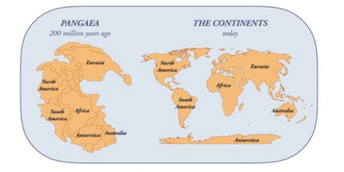
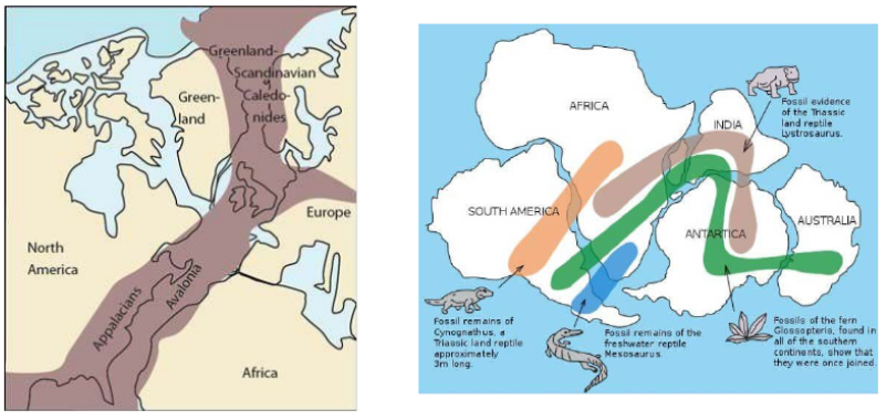
Plate Tectonic
What is Plate Tectonics?
Plate tectonics is a scientific theory that explains how major landforms are created as a result of Earth’s subterranean movements.
Crust - In geology, the outermost layer of the Earth.
Two Kinds of Crust
Continental Crust - the part of the crust that makes up the earth’s surface. About 40% of the surface of the earth is made up of this layer.
Oceanic Crust - the component of the earth’s crust that makes up the ocean basins.
The entire lithosphere of the Earth is broken into numerous segments called plates.
Earth has seven major tectonic plates:
Pacific Plate
North American Plate
Eurasian Plate
African Plate
Antarctic Plate
Indo-Australia Plate
South American Plate
Mantle Convection and Plate Motions
What force is great enough to move the continent?
Plates Motion Over Time
Scientists used satellites to measure plate motion precisely. The plates move very slowly – from about 1 to 12 centimeters per year. The North American and Eurasian plates move apart at a rate of 2.5 cm per year.
Type of Plate Boundaries
Divergent Plate Boundaries
The two plates move away from each other.
Can a crack in Earth’s crust be so wide that people can walk through it? In Iceland, it can!
Convergent Plate Boundaries
The two plates move toward each other.
The Andes mountains run for 8,900 km along the west coast of South America.
Transform Plate Boundaries
The two plates slide or grind past each other without diverging or converging.
The best example of this plate is the San Andreas fault which is bounded by the North American plate and the Pacific plate.
II. Earth Processes
Earth Processes are dynamic actions that take place within the earth or on its surface. Processes can be slow or fast.
The Earth's natural forces can be divided into two groups:
Constructive Earth Processes – any process that builds earth forms.
Destructive – any process that destroys earth forms.
2.1 Weathering
Weathering is the disintegration and decomposition of rocks, minerals, and artificial materials due to prolonged exposure to the environment. When a particle is loosened by a chemical or physical process but does not move, it is called weathering. But when moved away by gravity, water, ice, wind, etc. is then known as erosion.
Types of Weathering
Depending upon the mechanism and causes, weathering can be divided into two categories:
Physical weathering
Physical weathering, also called mechanical weathering, is a process that causes the disintegration of rocks, minerals, and soils without chemical change. The primary process in physical weathering is abrasion.
Physical Weathering may occur due to the following reasons:
Thermal Stress
Freezing and Thawing
Organisms
Chemical Weathering
It is the type of weathering in which the rock minerals are attacked by water, oxygen, or by alkaline or acidic materials dissolved in the water. The chemical structure of the rock minerals is altered.
Chemical Weathering may occur due to the following processes and reactions:
Carbonation
Hydrolysis
Oxidation
2.2 Work of Rivers, Wind, and Sea and their Engineering Importance
Geological Work by Rivers
During life while flowing from head to mouth, the rivers are capable of exerting greatly modifying influence over the topography of the region through which they follow.
The geological work by the river may be broadly divided into three well-defined phrases: erosion, transport, and deposition.
Method of River Erosion
By erosion, meant the disintegration and decomposition of the rocks and soil material by a natural agent through mechanical, chemical, and other physicochemical processes accompanied by the removal of the disintegrated or decomposed product to far-off places by the same agent.
Streams and rivers are the most powerful subaerial agents of erosion. Others are wind and ice.
River Valleys
A valley may be defined as low land surrounded on sides by inclined hill slopes and mountains. Every major river is associated with a valley of its own. In fact, rivers are responsible for the origin, development, and modification of their valleys through the well-understood process of river erosion.
Waterfalls
These are defined as magnificent jumps made by the stream or river water at certain specific parts of their course where there is a sudden and considered drop in the gradient of the channel.
Many falls are easily attributed to unequal erosion of the channel rocks within a short distance due to the inherent nature of rocks.
Deposition by Rivers
An entire load of the stream or a river will normally remain in transport unless there is a change in one or other factor responsible for its transport. The process of dropping down of its loads by any moving natural agent is technically called deposition. Wind rivers, glaciers, and marine water are the important natural agent that makes typical deposits.
Geological Works by Wind
Air in motion is called wind. The wind is one of three major agents of change in the surface of the earth, the other two being rivers and glaciers.
Wind acts as an agent of erosion, as a carrier for transporting particles and grains so eroded from one place, and also for depositing huge quantities of such windblown material at different places. There are three modes of activities i.e. erosion, transportation, and deposition by the wind.
Wind Erosion
Wind performs the work of erosion by at least three different methods: deflation, abrasion, and attrition.
Sedimentation Transport by Wind
Wind transport is carried out mainly by two distinctly different processes: suspension and situation.
Depositions by Wind
Sediments and particles once picked up by the wind from any source on the surface arrived forward for varying distances depending on the carrying capacity of the wind.
Geological Works of Sea
Marine water is spread over more than two third of the earth’s surface and is classed among the most powerful geological agents operating on the earth, Marine geology is fast acquiring the status of a separate branch of geology where the study of oceans, as said above has become the domain of specific branch of science.
Marine Erosion
Marine water erodes the rocks at the shore and elsewhere with which is comes in contact in a manner broadly similar to that of stream water. The work of erosion is accomplished in three ways. Hydraulic action, abrasion, and corrosion.
2.3 Origin, occurrence of earthquake
Origins Of Earthquakes
What is an earthquake?
An earthquake is the shaking of the ground caused by sudden motions along faults, or fractures in the earth. The earthquakes originate in the tectonic plate boundary. The focus is the point inside the earth where the earthquake started, sometimes called the hypocenter, and the point on the surface of the earth directly above the focus is called the epicenter. Earthquakes also originate from a volcanic eruption, bomb blasts, landslides, or anything else that suddenly releases energy on or in the Earth.
Two ways to measure the strength of an earthquake:
Magnitude is proportional to the energy released by an earthquake at the focus. It is calculated from earthquakes recorded by an instrument called seismograph. It is represented by Arabic Numbers (e.g. 4.8, 9.0).
Intensity is the strength of an earthquake as perceived and felt by people in a certain locality. It is a numerical rating based on the relative effects to people, objects, environment, and structures in the surrounding. The intensity is generally higher near the epicenter. It is represented by Roman Numerals (e.g. II, IV, IX).
Occurrence of Earthquakes
Earthquakes are usually caused when underground rock suddenly breaks and there is rapid motion along a fault. This sudden release of energy causes the seismic waves that make the ground shake. During and after the earthquake, the plates or blocks of rock start moving—and they continue to move until they get stuck again. The spot underground where the rock first breaks is called the focus, or hypocenter of the earthquake. The place right above the focus (at the ground surface) is called the epicenter of the earthquake.
There are two types of earthquakes:
Tectonic earthquakes – are produced by sudden movement along faults and plate boundaries.
Volcanic earthquakes - earthquakes induced by rising lava or magma beneath active volcanoes.
2.4 Mode of Occurrence and Prospecting
The modes of occurrence of elements in coal are an important basic concept in coal geochemistry and coal geology and have been applied to a broad range of studies.
Also, modes of occurrence of an element provide valuable clues as to the origin of the element;
the geochemical processes that the precursor peat and coal have undergone; and
how the element will behave upon coal cleaning, utilization, leaching, disposal.
Mode of Occurrence of minerals
Minerals are usually found in ores. The term ore is used to describe an accumulation of any minerals mixed with other elements.
The ores determine the cost of extraction and it is important to understand the main types of formation in which minerals occur.
Minerals generally occur in these following forms:
In igneous and metamorphic rocks minerals may occur in the cracks, faults or joint. The smaller occurrences are called veins and the larger are called lodes. Major metallic minerals like tin, copper, zinc and lead etc. are obtained from veins and lodes.
In sedimentary rocks a number of minerals occur in beds or layers. They have been formed as a result of deposition, accumulation and concentration in horizontal strata.
Another mode of formation involves the decomposition of surface rocks, and the removal of soluble constituents, leaving a residual mass of weathered material containing ores.
Certain minerals may occur as alluvial deposits in the sound of valley floors and the base of hills.
The ocean water contains vast quantities of minerals to be economically significant. Commonsalt, magnesium and water. The ocean beds too are rich manganese nodules.
Prospecting
Prospecting means exploring for minerals to a depth of fewer than 2 meters below the surface of the earth of any pre-existing excavation by means of a hand-held instrument. It is the stage of geological analysis. It is the exploration of territory and the search for minerals, fossils, precious metals, or mineral specimens.
Types of prospecting
Traditional Prospecting – its prospectors were looking for a simple, easy-to-find mineralization-native gold in stream gravels or in veins out copping on the rocky sides of the mountains.
Modern Prospecting – the modern prospector is a member of a team of highly trained specialists who use sophisticated equipment in a planned, systematic search. The team generally includes experts in geology, geophysics, geochemistry, computer techniques, drilling, mineral economics, metallurgy, and related fields.
Prospecting method
Direct method
Geochemical Method
Biochemical Method
Geobotanical Method
Remote Sensing
2.5 Groundwater
What Is Groundwater?
Groundwater is the water found underground in the cracks and spaces in soil, sand, and rock. It is stored in and moves slowly through geologic formations of soil, sand, and rocks called aquifers.
Groundwater - water that occurs in saturated zones beneath the soil surface.
The source of groundwater is rain and snow that falls to the ground, a portion of which percolates down into the ground to become groundwater.
Sources of Groundwater
Meteoric Water - It is water derived from precipitation.
Connate water - this is the water present in the rock right from the time of its deposition in an aqueous environment. It is commonly saline in nature.
Juvenile water - is also called magnetic water, it is the water formed in crevices or cracks or pores of cracks by condensation of the steam emanating from the molten masses. It is of only theoretical importance.
The Water Table
Saturated zone - the subsurface zone in which all rock openings are filled with water.
Water table - the upper surface of the zone of saturation.
Vadose zone - a subsurface zone in which rock openings are generally unsaturated and filled partly with air and partly with water, above the saturated zone.
Capillary fringe - a transition zone with higher moisture content at the base of the vadose zone just above the water table.
Perch water table - the top of a body of groundwater separated from the main water table beneath it by a zone that is not saturated.
The Movement of Groundwater
Most groundwater moves relatively slowly through the rock underground
Because it moves in response to differences in water pressure and elevation, water within the upper part of the saturated zone tends to move downward following the slope of the water table.
Water Bearing Qualities of Rocks
Aquifer
water-bearing porous soil or rock strata that yield significant water to wells or through which water can move easily.
good aquifers include sandstone, conglomerate, well-jointed limestone, bodies of sand and gravel, and some fragmental or fractured volcanic rocks such as columnar basalt.
Aquiclude
any water-bearing soil or rock that may be porous enough to hold a good quantity of water but is effectively impermeable they do not allow an easy or quick flow through it. Example: shale, slate, clays
Aquifuge
is an impermeable formation through which there is no possibility of storage or movement of water. Water-bearing soil or rock that retards the flow of groundwater. Example: compact interlocking granites, quartzites, slits, mudstones
Aquitard
It is a less common term used for an aquifuge or aquiclude that has become locally leaky due to the development of joints or cracks.
Types of Aquifers
Unconfined aquifer
partially filled aquifer exposed to the land surface and marked by a rising and falling water table. Water is in direct contact with the atmosphere through the porous material.
allows transferring of gases and water
Confined Aquifer (Artesian Aquifer)
an aquifer filled with pressurized water and separated from the land surface by a relatively impermeable bed, such as shale.
Also called artesian; these are under pressure
Hot Water Underground
Hot Springs - also known as a geothermal spring is a naturally occurring spring of water that emerges due to heated groundwater.
Water can gain heat in two ways while underground:
groundwater may circulate near a magma chamber or a body of cooling igneous rock
groundwater may circulate unusually deep in the earth
III. Importance of Geology in Civil Engineering
Geology provides a systematic study of the structure and properties of construction materials and their occurrence.
The selection of a site is important from the viewpoint of the stability of the foundation and the availability of construction materials.
Geology helps to identify areas susceptible to failures due to geological hazards such as earthquakes, landslides, weathering effects, etc.
knowledge about the nature of the rocks is very necessary for tunneling, constructing roads, and determining the stability of cuts and slopes.
The foundation problems of dams, bridges, and buildings are directly related to the geology of the area where they are to be built.
The knowledge of groundwater is necessary for connection with excavation works, water supply, mirrigation, and many other purposes. Hydrological maps provide information about the distribution of surface water channels and groundwater depth.
Geological maps help in planning civil engineering projects. It provides information about the structural deposition of rock types in the proposed area.
Geology helps in determining earthquake-prone areas. If any geological features like faults, folds, etc. are found, they have to be suitably treated to increase the stab