Unit 4 Notes (apes)
Plate Boundaries
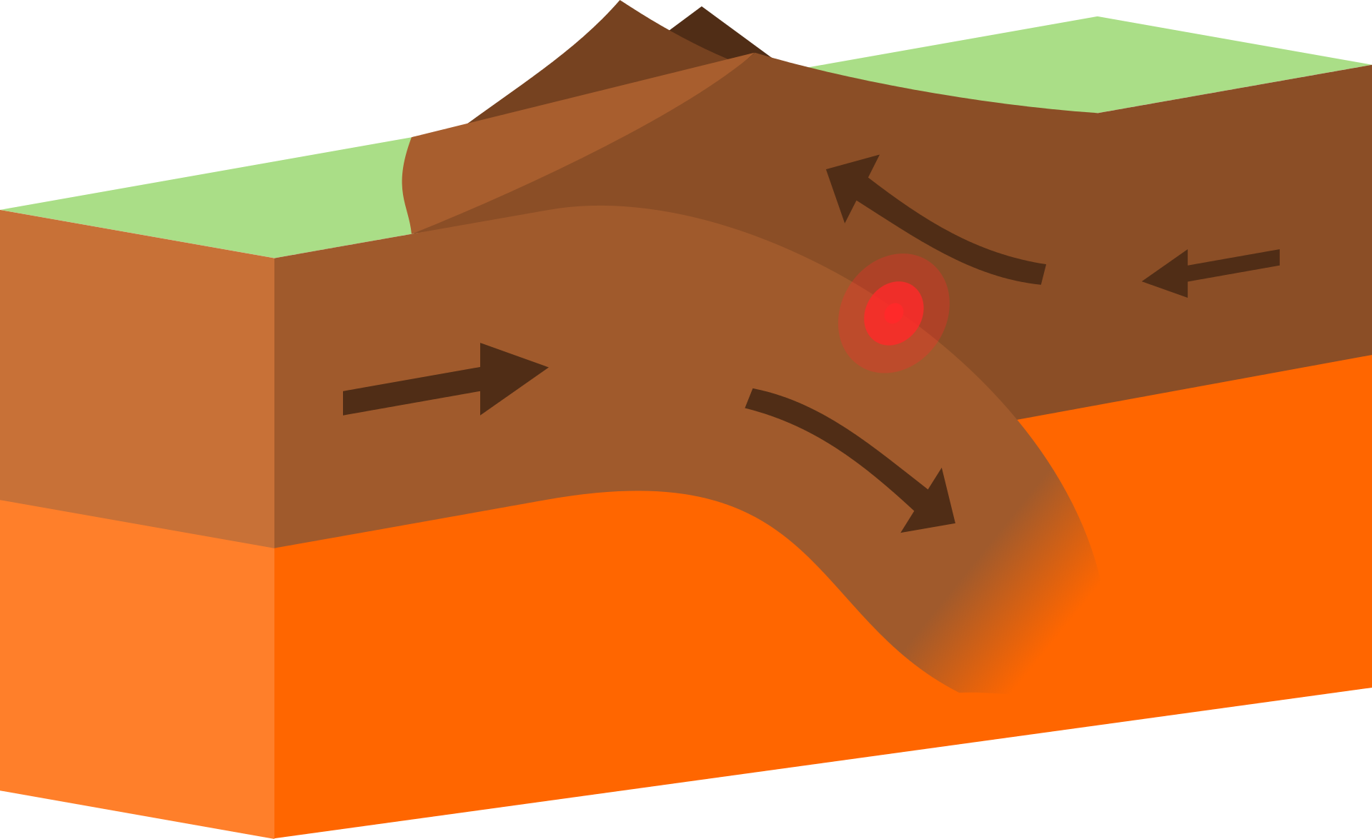
Convergent plates are tectonic plates that move towards each other. When they collide, they can create mountains, volcanoes, and earthquakes.
Subduction: the sideways and downward movement of the edge of a plate of the earth's crust into the mantle
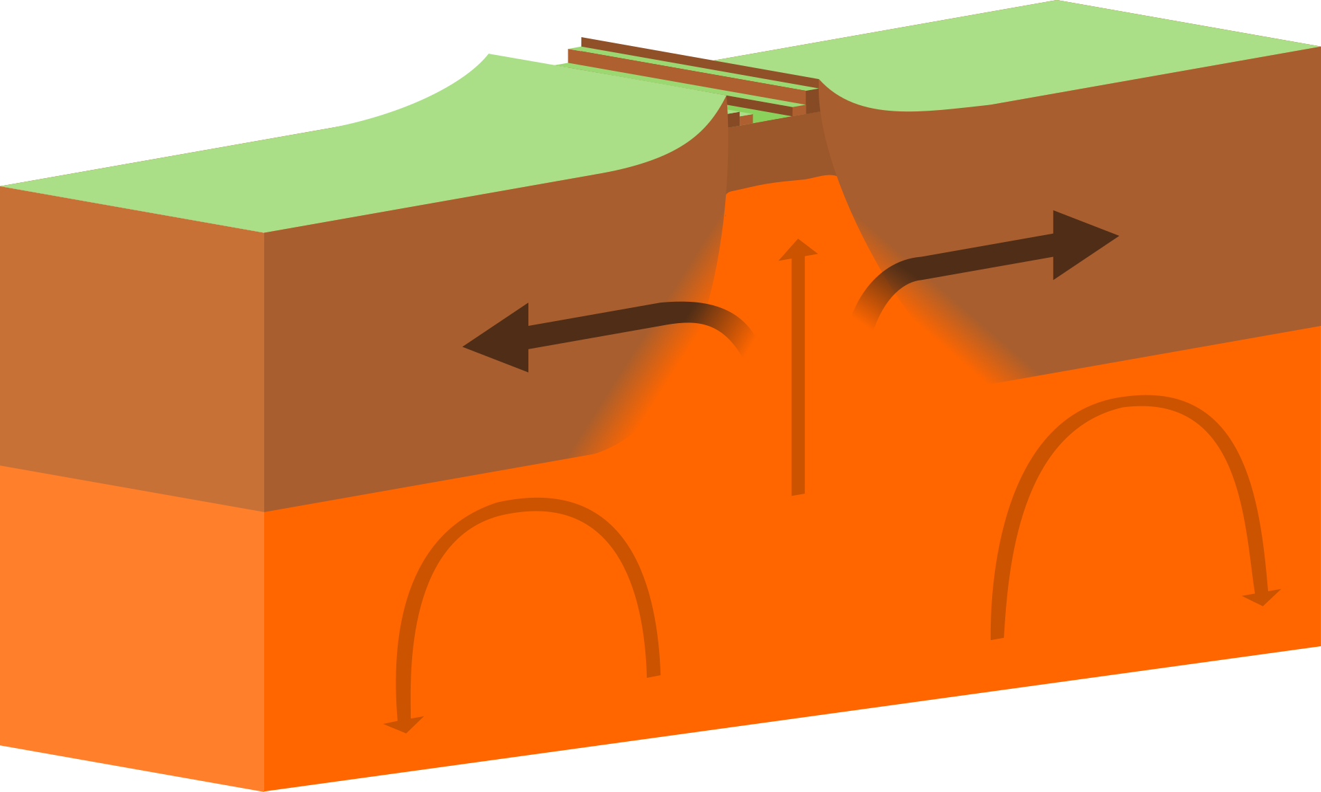
 Divergent plates move apart due to magma upwelling, creating a rift. Molten rock fills the gap, solidifies, and forms new crust. This seafloor spreading process forms mid-ocean ridges and new oceanic crust.
Rifts
Middle Ocean Ridges
Created by seafloor spreading
→ Magma moving through the boundary forming new crust
This crust is formed by the magma rising up through the crack the plates leave, think of a pimple
 Transform plates, or transform boundaries, are where tectonic plates slide horizontally past each other. These boundaries cause earthquakes. (Side note, they cause earthquakes mainly due to the bits of rock/earth snagging onto each other as they pass)
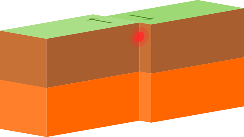 Earthquakes
Earthquakes can cause tsunamis when they occur under the ocean floor, displacing large amounts of water and creating powerful waves that can travel across the ocean.
One example, Fukushima Japan
Caused a nuclear power plant to malfunction, releasing radiation
Volcanos and Mountains
Convergent Belts (Volcanos)
Ring of Fire
Mediterranian Belt
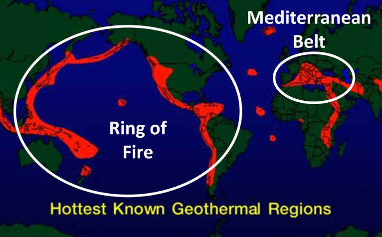 (the quality of that picture is horrible jesus christ)
Formation and Erosion
Parent material in soil refers to the underlying material from which soil forms. It can be rocks, minerals, organic matter, or sediments.
Formation Affected by:
Parent material (Rock)
Over time, deeper layers form
Climate (Warm, wet climate is best)
Topography (The shape of land) (Slope can affect)
Organisms (Burrow animals)
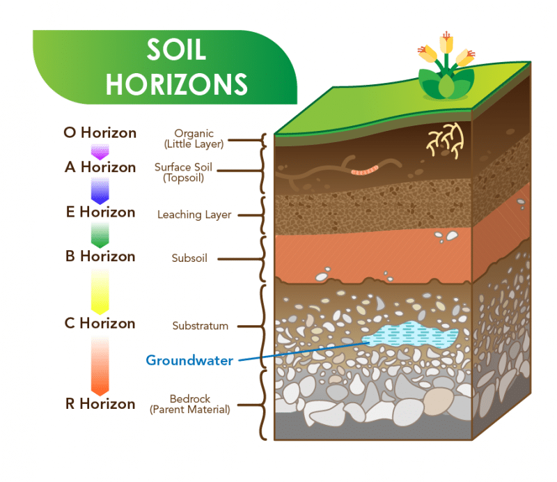
Horizons
O Horizon
Contains mostly organic things
Usually the smallest layer
Carbon to Carbon bonds (leaves)
A Horizon
Surface soil (topsoil/humus)
Most moist, usually dark brown in color
Where most plant roots are located
E Horizon
Leaching layer, removing minerals and nutrients
It is typically lighter in color and has a higher concentration of sand and silt particles compared to the layers above and below it.
B Horizon
Characterized by the accumulation of everything
Collects minerals and nutrients. It looks and feels different from the A horizon. It helps with water, nutrients, and root movement in the soil.
C Horizon
The C horizon in soil is the deepest layer of soil, also known as the parent material. It consists of partially weathered or unweathered rock and has little to no organic matter. Its main function is to provide a source of minerals for the upper soil layers.
R Horizon
The R horizon in soil refers to the bedrock layer, which is the deepest layer of soil. It consists of unweathered parent material and is typically found beneath the other soil horizons.
 Soil
Soil
Made out of
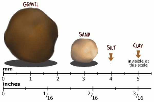
45% Soil particles, specifically sand, silt, and clay
25% Air
5% Organic matter
Causes of Erosion
Natural: Water, wind, and gravity can cause erosion
Anthropogenic: Human-caused erosion
Deforestation
(through the roots as they hold soil in place)
Agriculture
(Tilling, messing up the soil by disrupting soil structure)
Pesticides and Fertilizer
(Changes the chemistry of the soil)
Overgrazing
(Short grass = short roots)
Composition and Properties
What is it?
A renewable resource that can be replenished but can also be depleted (this is a cycle)
Porosity
The space between particles
Sand has a high porosity
Silt has a medium porosity
Clay has a low porosity
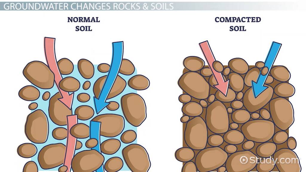 Permeability
Porosity affects permeability
Permeability is the ability for water to move through different materials
Clay has a low permeability
Silt has a medium permeability
Sand has a high permeability
This is because each of these materials is compacted in different intensities
Water Holding Capacity
Permeability affects water-holding capacity
How well soil can hold water
Clay has a high water-holding capacity
Silt has a medium holding capacity
Sand has a low holding capacity
The water-holding capacity of different materials varies based on their physical and chemical properties, such as porosity, surface area, and chemical composition. Materials with high porosity and larger surface area, like soil, can hold more water compared to materials with low porosity and smaller surface area, such as rocks or metals.
Chemical Properties
Plants need nutrients to grow
These nutrients are found in soil
Nitrogen (N)
Phosphorus (P)
Potassium (K)
pH
These factors can affect the growth of plants. Adjusting these elements to what fits best will lead to better plant growth.
Biological Properties
Organisms put nutrients in the soil due to decomposition
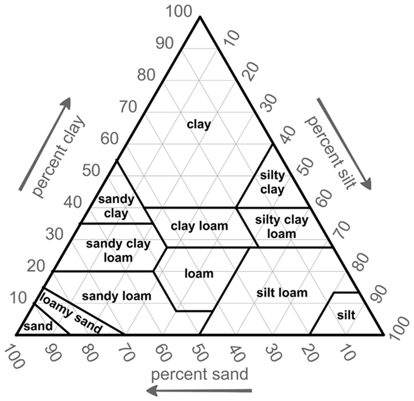
Soil Texture Triangle
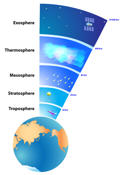
Layers of the Atmosphere
Atmosphere Composition
The Earth's atmosphere is primarily composed of nitrogen (78%), oxygen (21%), and traces of other gases such as argon, carbon dioxide, and water vapor.
Layers
Troposphere
The troposphere is the lowest layer of Earth's atmosphere, extending up to about 10-15 kilometers (6-9 miles) in altitude. It is where weather occurs and contains most of Earth's air mass. The troposphere has a decreasing temperature with increasing altitude. The troposphere is important for regulating Earth's climate and supporting life.
Stratosphere
The stratosphere is the second layer of Earth's atmosphere, situated between the troposphere and mesosphere. It spans from 10 to 50 kilometers above the surface and houses the ozone layer. The stratosphere's temperature rises as altitude increases due to ozone absorption of UV radiation. Commercial airliners prefer the lower stratosphere for its stability and reduced turbulence.
Mesosphere
The mesosphere is the third layer of the Earth's atmosphere, found between the stratosphere and thermosphere. It spans 50 to 85 kilometers (31 to 53 miles) above the surface. Temperatures decrease as altitude increases, reaching a low of -90 degrees Celsius (-130 degrees Fahrenheit). Mesospheric clouds, or noctilucent clouds, are present here, and meteors burn up upon entry.
Thermosphere
The thermosphere is a layer above the mesosphere and below the exosphere in the Earth's atmosphere. It spans from 80 to 600 kilometers above the surface. Temperatures can reach 2,500 degrees Celsius due to solar radiation absorption, but it feels cold due to low particle density. The International Space Station orbits in this layer.
Exosphere
The exosphere is Earth's outermost atmospheric layer, extending from 500 kilometers above the surface to space. It consists of low-density gases like hydrogen and helium, with traces of other gases. Unlike other layers, it has no clear boundary and thins out with increasing altitude. Its low density makes gas retention difficult. It is crucial for satellite and spacecraft operations and contributes to the creation of auroras and airglow through interactions with charged particles from the Sun.
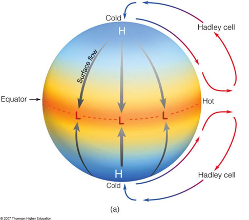
Global Wind Patterns
Warm air rises near the equator, forming low-pressure zones
This leads to abundant rainfall in tropical regions
The cooled air then moves towards the poles, creating subtropical jet streams
It falls in the subtropics (the 30-degree line both in the northern hemisphere and the southern hemisphere) creating high-pressure zones and dry conditions
This influences weather patterns, trade winds, and global precipitation distribution
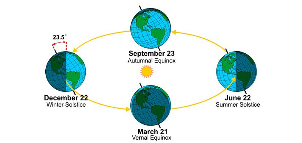
Seasons
The rotation of the earth affects the seasons through the tilt of its axis
Different parts of the planet receive varying amounts of sunlight throughout the year
during the summer, the hemisphere is tilted towards the sun, experiencing longer days with more direct sunlight
In contrast, during winter, the hemisphere tilted away from the sun receives less sunlight and shorter days, leading to cooler temperatures.
The equinoxes, occurring in spring and autumn, mark the times when the tilt of the Earth's axis is neither towards nor away from the Sun, resulting in more equal day and night lengths
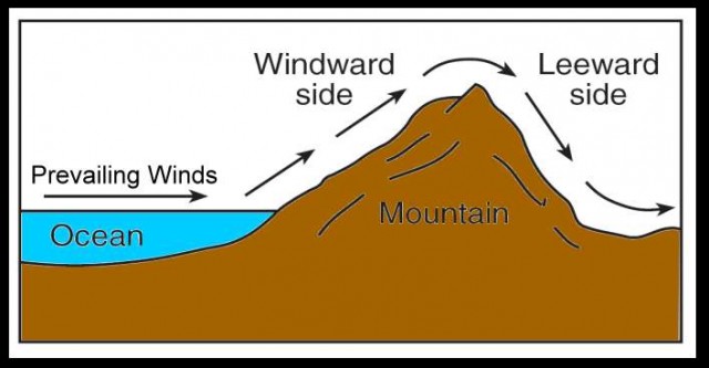
Earth's Geography and Climate
The shape and elevation of the Earth's land can block the movement of air masses
This causes differences in temperature and precipitation on either side of the mountain range
The Rain shadow effect results in one side of a mountain receiving more precipitation than the other side
On the windward side, warm, moist air rises up the mountain, cools, and falls as precipitation
The leeward side doesn't receive much precipitation because the air doesn't have much moisture left
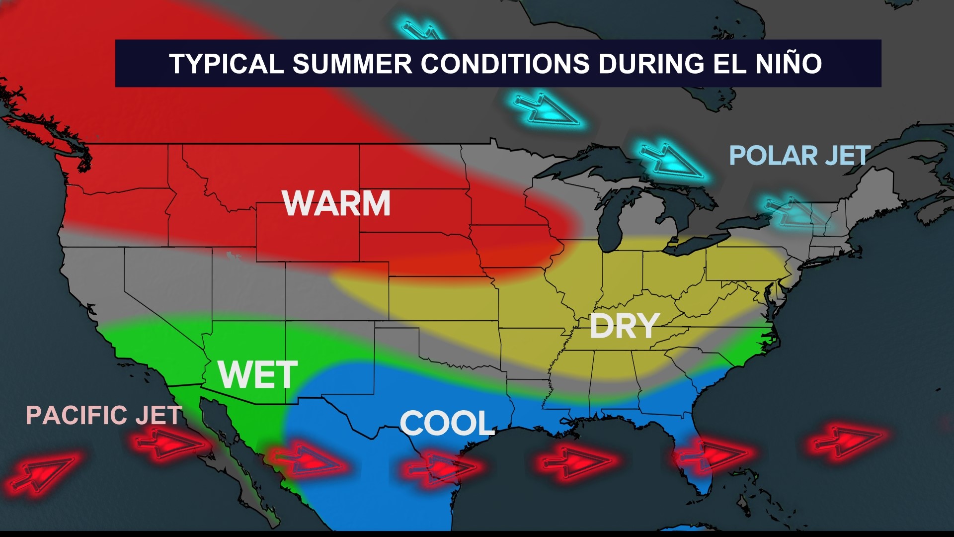
El Nino and La Nina
El Nino
During El Nino, trade winds weaken, reducing cold weather upwelling along the western coast of South America.
This affects weather patterns, causing changes in rainfall, temperature, and storm activity worldwide
El Nino results in droughts in Southeast Asia and disrupts fisheries, agriculture, and water resources
This leads to economic and social consequences
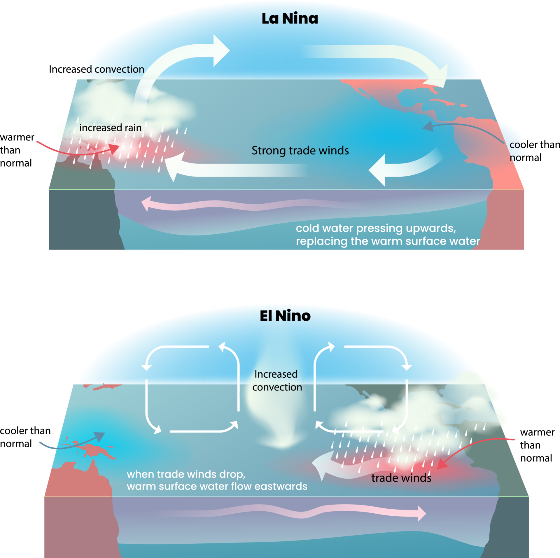
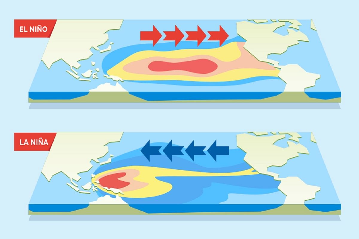
Normal Weather Pattern
Takes place in the Tropical Pacific
Equatorial water flows from west to east
Cold, nutrient-rich water flows from the East Pacific to the West
La Nina
Strengthens normal conditions
Can Intensify hurricane conditions (Formation in Atlantic Ocean)
Effects of El Nino
Suppressed upwelling and less productive fisheries in South America
Warmer winter in much of North America
Increased precipitation nd flooding in America (west coast specifically)
Drought in South east Asian and austrialia (colder)
Decreased hurricane activity in the Atlantic Ocean
Weakened monsoon activity in India and southeast Asia
Effects of La Nina
Stronger upwelling and better fisheries in South America than normal
Worse tornado activity in US and Hurricane in the Atlantic
Cooler, drier weather in the Americas
Rainier, warmer, increased monsoons in South East Asia