
Mass movements - landslides
LANDSLIDES
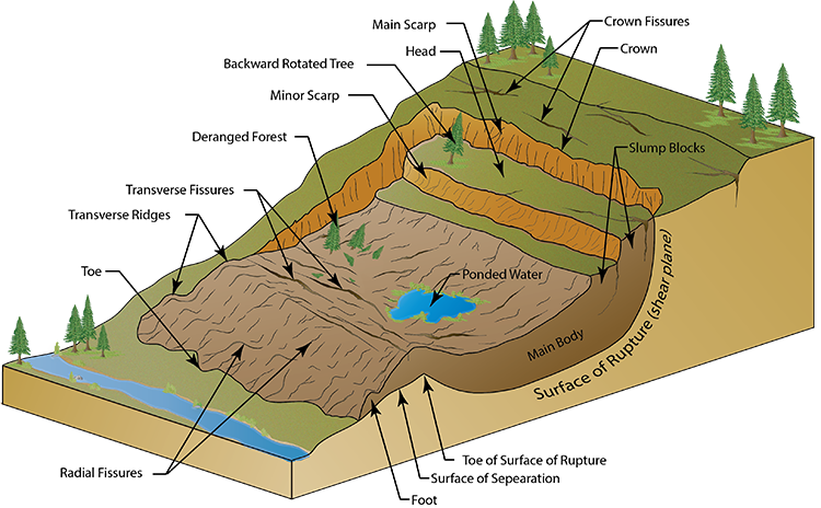
Also known as slump, these are rapid sliding of masses of earth, rock material or regolith. Landslides move ‘en masse’ i.e., the mass of earth that slides do not suffer internal derangement of particles whereas in the earth flow or the mud flows, there is internal derangement of the particles.
Causes of landslides.
Physical causes of landslides
They occur in climates that are characterized by their intense heavy rainfall. When prolonged rain falls, water infiltrates into the topsoil which makes the soil become heavier and therefore more vulnerable to the pull of gravity. When soil absorbs all the water that it can hold, it is said to be saturated. Soil is therefore heaviest and most susceptible to the effects of gravity, when saturated. When large areas of soil become saturated on steep slopes, the pull of gravity causes the top layers of the soil to slide downhill, therefore resulting in a landslide.
Steep slopes are more vulnerable to frequent landslide occurrence because these slopes are close to failure, so their stability is likely to be affected by a small triggering such as an earthquake. Such earth movements are unpredictable and therefore are a deadly type of natural disaster that are the leading reason for landslides or rock falls occurring worldwide. Loose soil, rocks and boulders can easily be dislodged from hilly areas and allowed to move downhill when the violent shaking of the ground transpires. Landslides are more likely to take place when the earthquake is of a high magnitude.
Human Induced Activities that produce landslides:
Most of the landslides are related to human activities like road construction which disturb the natural slope characteristics and increase their probability of failure.
The main cause of damage in Caribbean Islands due to landslides can be attributed to the building on unstable slopes.
A damaged water main may provide lubrication that is enough to move material on soil mantled slopes.
Deforestation is the removal or cutting down of trees and other types of vegetation from the land. The firm roots of the trees help to keep the soil in place, even when it absorbs water, thus diminishing the effects that gravity has on the soil. It is when these trees are removed that the bare and exposed soil is left defenseless against the pulling force of gravity when water saturated, resulting in deadly landslides.
Quarrying or rock mining refers to the cutting away or excavation of hilly or mountainous areas so that rocks and minerals can be extracted from the land. Quarrying that is rampant in the Northern Range of the Caribbean Islands results in the steepening of the slope and land being left devoid of trees and vegetation. Without trees to hold the soil in place, soil movement occurs easily and rapidly.
1. SLOPE ANGLE
The area and path of the landslide was located on a mountain with an angle of 20-40degrees. This allowed a lot of speed to be built and made excavation difficult as it kept the debris unstable.
2. WEATHER
The Thredbo area has been experiencing considerable rain during the season. This heightened instability as the water melted the snow, but didn't freeze as it was running.
3. WATER CONTENT
The site of the slide was covered in snow resulting in a large water content. This causes the land beneath to become slushy and unstable. A burst water main underneath the slide area also contributed to the water content, as it was buried beneath the soil and made the support beneath the snow less solid.
4. HUMAN FACTORS
The slide at the top was being formed by a leaking water main that had not been maintained properly near Alpine Way road, which was above very unstable soil as it had been made as a construction pathway and was not originally intended to be used as a long term main road. This slide then hit four storey Carinya lodge, shearing it in half and destabilising the ground beneath, largening the the amount of debris. All of the debris and earth then hit the Bimbadeen ski lodge and staff lodge at a very high speed, where the slide slowed down and stopped.
The Thredbo Landslide was a flow landslide, meaning that the land slipped of and fell down in a semi liquid state.
Measures against landslides
The simplest way to reduce the consequences of a hazard is to avoid developing in hazard prone areas. However, this is not always possible, so risk reduction and mitigation measures may be required to lessen the severity of a disaster.
Landslide mitigation focuses on the process of identification of cost-effective structural and non-structural landslide mitigation options that can be implemented during the planning and design of the building, or for retrofitting if the building has already been constructed.
Hazard mapping- The first step involves collecting information related to triggering mechanism and extent of landslide for example volume (m3), Run-out distance (m), and Slope angle. This information can be obtained from land slide inventory maps, GIS maps and past data. The risk maps at a larger scale, such as greater than 1:500 can be used for the overall planning and locating the buildings, where smaller scale site maps and investigations will be needed for planning of the mitigation measures for individual buildings.
Hard engineering measures to protect slopes
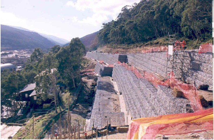
Following a landslide in the mountainous Thredbo area, Thredbo Landslide (30 July 1997) reconstruction of the Alpine Way involved major engineering works including the installation of reinforced gabion retaining walls.
Fill Slopes and Soil Nailing
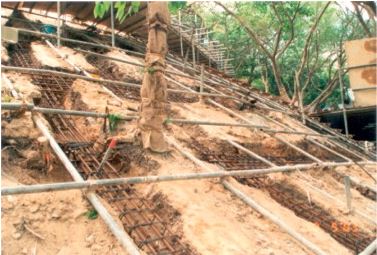
It involves the installation of soil nails into the soil with the provision of a surface grillage connecting the soil nails head. The existing trees can be preserved during the construction process. The soil nails are embedded in competent subsurface stratum to ensure enough anchorage against pull-out. Because of the construction advantages offered using soil nailing, the method is now commonly used for upgrading fill slope.
Deep Shafts (Dowels)
Large and deep-seated landslides ask for heavy constructions that stabilize such unstable slopes. Usually, this kind of structures cannot be built-in fast-moving landslide masses. One option is to build them during dormant phases of a landslide (dry periods without rain or cold wintertime). The other is to slow down the landslide movement to be able to build large supporting structures, such as supporting walls or similar concrete structures. To slow down a fast-moving landslide (> 10 cm/day) it is often necessary first to drain surficial waters by a drainage system and then to lower groundwater level.
Ground Anchor Wall
The Richardson Highway project is located on Alaska Highway 2 at Mile point 296.3, which is about 60 miles east of Fairbanks along a stretch of steep side-hill cut/fill above the Tanana River. A landslide affected approximately 140 feet of the highway. Significant movement in the pavement was first identified in 1996. During the summers of 1999 and 2000, the rate of landslide movement accelerated over previous years. Maintenance was required to grade the roadway to keep it safe for travel and this was done by constructing a ground anchor wall.
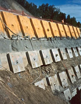 Ground Anchor Wall during Construction
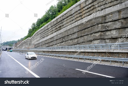
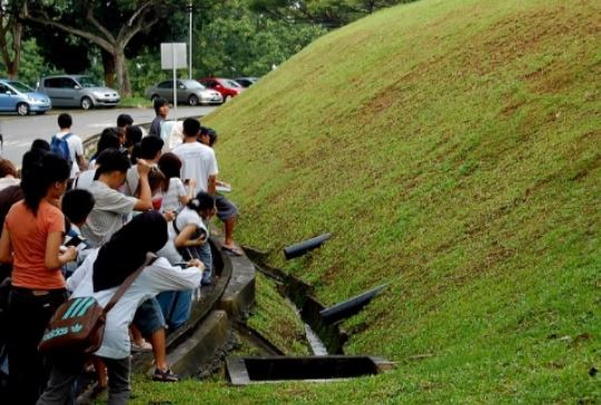
Horizontal Drain to Dewater the Land Slide
The Hillis Hill Landslide area is located on a west-facing slope above the Lewis River, approximately 1 mile south of Woodland on the Pacific Highway (Clark County Road 1) USA. The slide area is a locally active portion of a much larger ancient landslide that extends approximately 1,200 feet along the highway, and 2,000 feet upslope from the Lewis River. Landslide Technology (LT) assisted Clark County with the stabilization of two active segments of the slide, which were termed the “Hillis Hill” and “Hillis Hill No. 2” Slides. The investigation and repair of the original Hillis Hill Slide occurred between 1997 and 2001. Following phases of investigation, monitoring, and design, the original slide was mitigated with a horizontal drain system installed in October 2001 and has remained stable since then.
The Vetiver Grass System can effectively protect slopes or significantly reduce the risk of landslides.
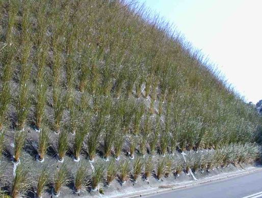
This is because vetiver grass roots have a high tensile strength of 75 MPa that can increase shear strength of soil by a factor of 40. Also, when planted on slopes vetiver grass will reduce hydraulic pressures through the removal of water from the regolith hence reduce the chances of landslides.
Use of terraces and benches.
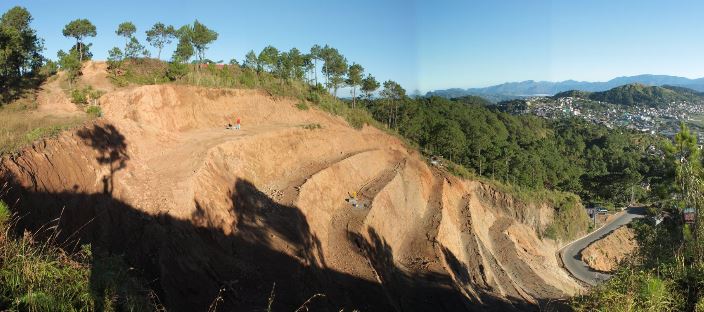
Creating benches or terraces on a steep hillside slope has the effective effect of stabilizing the slopes and prevent landslides from being common. This benching has been observed to be effective at Brgy. Puguis, La Trinidad, Benguet
Educational campaigns-
Landslide Warning Signs
Springs, seeps, or saturated ground in areas that have not typically been wet before.
New cracks or unusual bulges in the ground, street pavements or sidewalks.
Soil moving away from foundations.
Ancillary structures such as decks and patios tilting and/or moving relative to the main house.
Tilting or cracking of concrete floors and foundations.
Broken water lines and other underground utilities.
Leaning telephone poles, trees, retaining walls or fences.
Offset fence lines.
Sunken or down dropped roadbeds.
Rapid increase in creek water levels, possibly accompanied by increased turbidity (soil content).
Sudden decrease in creek water levels though rain is still falling or just recently stopped.
Sticking doors and windows, and visible open spaces indicating jambs and frames out of plumb.
A faint rumbling sound that increases in volume is noticeable as the landslide nears.
Unusual sounds, such as trees cracking or boulders knocking together, might indicate moving debris.
What makes a people vulnerable to landslides?
Physical Vulnerability:
Building on hilly areas or on slopes: These areas are considered to be most prone to landslides and building on hilly areas or on slopes increases one’s chances of being negatively affected by landslides.
Not building homes on the right foundation. A house may need to have a shallow or deep foundation depending on the type of soil and therefore the extent of soil movement of the area. Building on the right type of foundation would decrease the impact of soil movement on the structure.
Building homes in areas that are traditionally known to be prone to landslides. Landslides usually occur in the same areas and constructing in an area that is known to be affected by landslides would increase one’s vulnerability.
Not using proper building codes, buildings that lack structural integrity are more susceptible to be damaged by a landslide than a sturdier building.
Buried pipelines, brittle pipes, burst water mains: Buried pipelines must be made from a flexible material so that they would shift with the soil movements and not be more prone to breaking when there’s soil movement.
Social Vulnerability:
Family structure- Female headed households and households with many dependencies are more vulnerable to the negative impacts of disasters.
Illiteracy- Lack of education on the causes and mitigation measures that one can use to reduce the effects of flooding.
Lack of personal safety- Some individuals have higher personal levels of acceptable risk and would therefore risk living in areas that are very prone to flooding.
Special needs individuals such as the elderly and the mentally challenged would be more vulnerable to disasters.
Economic Vulnerability:
Poverty
Unemployment
Debt
Environmental Vulnerability:
Quarrying, this leaves the land barren and susceptible to soil movements.
Deforestation
Soil type found in the area: certain soil types are more prone to ground movement than others, therefore it’s always important to determine the soil type, it would give an indication of what type of foundation you would need to have to decrease the impact of soil movement.
How to reduce vulnerability:
Conducting a soil analysis before constructing so that a suitable foundation can be made.
Public education- public education initiatives would increase the populace awareness of the hazard and what they can do to mitigate against it. Such initiatives would make people better aware of the risks that they face, especially those that live in high-risk areas.
Build retaining walls in areas that are prone to landslides.
Policies regarding the use of proper building codes when constructing structures should be enforced.
Provide incentives and monetary help to special needs individuals so that they would have the finances to build more resilient homes.
Al Jazeera English
19 June 21, 2020
At least 13 people have died and several others are missing in a landslide near Ivory Coast's main city Abidjan after a drainage channel burst following torrential rains.
"The provisional death toll is 13 and searches are continuing," Abidjan's Prefect Vincent Toh Bi said on Thursday, adding that "20 houses were swept away" in the teeming suburb of Anyama, north of the coastal city.
About 10 people were hospitalised, locals said.
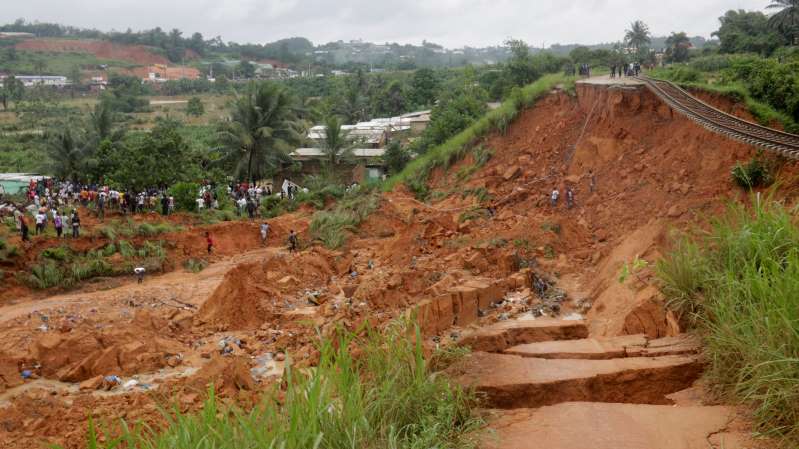 © Thomson Reuters A general view of the area affected by landslide after unusually heavy rains in Anyama near Abidjan, Ivory Coast June 18, 2020. REUTERS/ Thierry Gouegnon "I have lost my three-year-old son and I am looking for his body," Aboubacar Dagnon told AFP news agency, after his wife's home was flattened.
Another resident said a part of a hillock broke away and cascaded on homes at about 8am local time after a drainage channel collapsed.
The landslide occurred in an area which saw more than three times as much rain between June 12-15 than is usual, Defence Minister Hamed Bakayoko told journalists.
Amidou Sylla, the mayor of Anyama, said the death toll was expected to rise as the search for survivors was still going on.
"The toll could get higher with ongoing search. We could have at least 20 dead as a result of the landslides because there are still a lot of houses to explore," Sylla told Reuters News Agency.
A dead cat is seen in Anyama, Ivory Coast after a landslide killed at least 13 people overnight [Thierry Gouegnon/Reuters]
Abidjan is home to some five million people, many of whom live in precarious shantytowns in flood-prone or dangerous zones.
Landslides and deadly floods are common in the city during the rainy season which runs from April until the end of October, routinely costing lives in informal settlements built into eroding hillsides.
There were heavy downpours in other parts of the country this week, raising concerns they could damage crops in the world's top cocoa producer.
Farmers in the western region of Soubre, at the heart of the Ivorian cocoa belt, said the rains were so heavy they fear the torrents could pluck off young pods and flowers from trees. This could reduce crop output in August and September.
They added that harvested beans could become mouldy in the coming week as the weather remained cloudy, making it difficult to dry their beans properly because of lack of sunshine.
"The rains are a bit heavy," said Salame Kone, who farms near Soubre, adding that if the downpours continued, farms could become flooded.
Data collected by Reuters showed rainfall in Soubre was 229.3mm (9 inches) in the week to Wednesday, 175.2mm (6.89 inches) above the five-year average.
LANDSLIDES
Also known as slump, these are rapid sliding of masses of earth, rock material or regolith. Landslides move ‘en masse’ i.e., the mass of earth that slides do not suffer internal derangement of particles whereas in the earth flow or the mud flows, there is internal derangement of the particles.
Causes of landslides.
Physical causes of landslides
They occur in climates that are characterized by their intense heavy rainfall. When prolonged rain falls, water infiltrates into the topsoil which makes the soil become heavier and therefore more vulnerable to the pull of gravity. When soil absorbs all the water that it can hold, it is said to be saturated. Soil is therefore heaviest and most susceptible to the effects of gravity, when saturated. When large areas of soil become saturated on steep slopes, the pull of gravity causes the top layers of the soil to slide downhill, therefore resulting in a landslide.
Steep slopes are more vulnerable to frequent landslide occurrence because these slopes are close to failure, so their stability is likely to be affected by a small triggering such as an earthquake. Such earth movements are unpredictable and therefore are a deadly type of natural disaster that are the leading reason for landslides or rock falls occurring worldwide. Loose soil, rocks and boulders can easily be dislodged from hilly areas and allowed to move downhill when the violent shaking of the ground transpires. Landslides are more likely to take place when the earthquake is of a high magnitude.
Human Induced Activities that produce landslides:
Most of the landslides are related to human activities like road construction which disturb the natural slope characteristics and increase their probability of failure.
The main cause of damage in Caribbean Islands due to landslides can be attributed to the building on unstable slopes.
A damaged water main may provide lubrication that is enough to move material on soil mantled slopes.
Deforestation is the removal or cutting down of trees and other types of vegetation from the land. The firm roots of the trees help to keep the soil in place, even when it absorbs water, thus diminishing the effects that gravity has on the soil. It is when these trees are removed that the bare and exposed soil is left defenseless against the pulling force of gravity when water saturated, resulting in deadly landslides.
Quarrying or rock mining refers to the cutting away or excavation of hilly or mountainous areas so that rocks and minerals can be extracted from the land. Quarrying that is rampant in the Northern Range of the Caribbean Islands results in the steepening of the slope and land being left devoid of trees and vegetation. Without trees to hold the soil in place, soil movement occurs easily and rapidly.
1. SLOPE ANGLE
The area and path of the landslide was located on a mountain with an angle of 20-40degrees. This allowed a lot of speed to be built and made excavation difficult as it kept the debris unstable.
2. WEATHER
The Thredbo area has been experiencing considerable rain during the season. This heightened instability as the water melted the snow, but didn't freeze as it was running.
3. WATER CONTENT
The site of the slide was covered in snow resulting in a large water content. This causes the land beneath to become slushy and unstable. A burst water main underneath the slide area also contributed to the water content, as it was buried beneath the soil and made the support beneath the snow less solid.
4. HUMAN FACTORS
The slide at the top was being formed by a leaking water main that had not been maintained properly near Alpine Way road, which was above very unstable soil as it had been made as a construction pathway and was not originally intended to be used as a long term main road. This slide then hit four storey Carinya lodge, shearing it in half and destabilising the ground beneath, largening the the amount of debris. All of the debris and earth then hit the Bimbadeen ski lodge and staff lodge at a very high speed, where the slide slowed down and stopped.
The Thredbo Landslide was a flow landslide, meaning that the land slipped of and fell down in a semi liquid state.
Measures against landslides
The simplest way to reduce the consequences of a hazard is to avoid developing in hazard prone areas. However, this is not always possible, so risk reduction and mitigation measures may be required to lessen the severity of a disaster.
Landslide mitigation focuses on the process of identification of cost-effective structural and non-structural landslide mitigation options that can be implemented during the planning and design of the building, or for retrofitting if the building has already been constructed.
Hazard mapping- The first step involves collecting information related to triggering mechanism and extent of landslide for example volume (m3), Run-out distance (m), and Slope angle. This information can be obtained from land slide inventory maps, GIS maps and past data. The risk maps at a larger scale, such as greater than 1:500 can be used for the overall planning and locating the buildings, where smaller scale site maps and investigations will be needed for planning of the mitigation measures for individual buildings.
Hard engineering measures to protect slopes
Following a landslide in the mountainous Thredbo area, Thredbo Landslide (30 July 1997) reconstruction of the Alpine Way involved major engineering works including the installation of reinforced gabion retaining walls.
Fill Slopes and Soil Nailing
It involves the installation of soil nails into the soil with the provision of a surface grillage connecting the soil nails head. The existing trees can be preserved during the construction process. The soil nails are embedded in competent subsurface stratum to ensure enough anchorage against pull-out. Because of the construction advantages offered using soil nailing, the method is now commonly used for upgrading fill slope.
Deep Shafts (Dowels)
Large and deep-seated landslides ask for heavy constructions that stabilize such unstable slopes. Usually, this kind of structures cannot be built-in fast-moving landslide masses. One option is to build them during dormant phases of a landslide (dry periods without rain or cold wintertime). The other is to slow down the landslide movement to be able to build large supporting structures, such as supporting walls or similar concrete structures. To slow down a fast-moving landslide (> 10 cm/day) it is often necessary first to drain surficial waters by a drainage system and then to lower groundwater level.
Ground Anchor Wall
The Richardson Highway project is located on Alaska Highway 2 at Mile point 296.3, which is about 60 miles east of Fairbanks along a stretch of steep side-hill cut/fill above the Tanana River. A landslide affected approximately 140 feet of the highway. Significant movement in the pavement was first identified in 1996. During the summers of 1999 and 2000, the rate of landslide movement accelerated over previous years. Maintenance was required to grade the roadway to keep it safe for travel and this was done by constructing a ground anchor wall.
Ground Anchor Wall during Construction
Horizontal Drain to Dewater the Land Slide
The Hillis Hill Landslide area is located on a west-facing slope above the Lewis River, approximately 1 mile south of Woodland on the Pacific Highway (Clark County Road 1) USA. The slide area is a locally active portion of a much larger ancient landslide that extends approximately 1,200 feet along the highway, and 2,000 feet upslope from the Lewis River. Landslide Technology (LT) assisted Clark County with the stabilization of two active segments of the slide, which were termed the “Hillis Hill” and “Hillis Hill No. 2” Slides. The investigation and repair of the original Hillis Hill Slide occurred between 1997 and 2001. Following phases of investigation, monitoring, and design, the original slide was mitigated with a horizontal drain system installed in October 2001 and has remained stable since then.
The Vetiver Grass System can effectively protect slopes or significantly reduce the risk of landslides.
This is because vetiver grass roots have a high tensile strength of 75 MPa that can increase shear strength of soil by a factor of 40. Also, when planted on slopes vetiver grass will reduce hydraulic pressures through the removal of water from the regolith hence reduce the chances of landslides.
Use of terraces and benches.
Creating benches or terraces on a steep hillside slope has the effective effect of stabilizing the slopes and prevent landslides from being common. This benching has been observed to be effective at Brgy. Puguis, La Trinidad, Benguet
Educational campaigns-
Landslide Warning Signs
Springs, seeps, or saturated ground in areas that have not typically been wet before.
New cracks or unusual bulges in the ground, street pavements or sidewalks.
Soil moving away from foundations.
Ancillary structures such as decks and patios tilting and/or moving relative to the main house.
Tilting or cracking of concrete floors and foundations.
Broken water lines and other underground utilities.
Leaning telephone poles, trees, retaining walls or fences.
Offset fence lines.
Sunken or down dropped roadbeds.
Rapid increase in creek water levels, possibly accompanied by increased turbidity (soil content).
Sudden decrease in creek water levels though rain is still falling or just recently stopped.
Sticking doors and windows, and visible open spaces indicating jambs and frames out of plumb.
A faint rumbling sound that increases in volume is noticeable as the landslide nears.
Unusual sounds, such as trees cracking or boulders knocking together, might indicate moving debris.
What makes a people vulnerable to landslides?
Physical Vulnerability:
Building on hilly areas or on slopes: These areas are considered to be most prone to landslides and building on hilly areas or on slopes increases one’s chances of being negatively affected by landslides.
Not building homes on the right foundation. A house may need to have a shallow or deep foundation depending on the type of soil and therefore the extent of soil movement of the area. Building on the right type of foundation would decrease the impact of soil movement on the structure.
Building homes in areas that are traditionally known to be prone to landslides. Landslides usually occur in the same areas and constructing in an area that is known to be affected by landslides would increase one’s vulnerability.
Not using proper building codes, buildings that lack structural integrity are more susceptible to be damaged by a landslide than a sturdier building.
Buried pipelines, brittle pipes, burst water mains: Buried pipelines must be made from a flexible material so that they would shift with the soil movements and not be more prone to breaking when there’s soil movement.
Social Vulnerability:
Family structure- Female headed households and households with many dependencies are more vulnerable to the negative impacts of disasters.
Illiteracy- Lack of education on the causes and mitigation measures that one can use to reduce the effects of flooding.
Lack of personal safety- Some individuals have higher personal levels of acceptable risk and would therefore risk living in areas that are very prone to flooding.
Special needs individuals such as the elderly and the mentally challenged would be more vulnerable to disasters.
Economic Vulnerability:
Poverty
Unemployment
Debt
Environmental Vulnerability:
Quarrying, this leaves the land barren and susceptible to soil movements.
Deforestation
Soil type found in the area: certain soil types are more prone to ground movement than others, therefore it’s always important to determine the soil type, it would give an indication of what type of foundation you would need to have to decrease the impact of soil movement.
How to reduce vulnerability:
Conducting a soil analysis before constructing so that a suitable foundation can be made.
Public education- public education initiatives would increase the populace awareness of the hazard and what they can do to mitigate against it. Such initiatives would make people better aware of the risks that they face, especially those that live in high-risk areas.
Build retaining walls in areas that are prone to landslides.
Policies regarding the use of proper building codes when constructing structures should be enforced.
Provide incentives and monetary help to special needs individuals so that they would have the finances to build more resilient homes.
Al Jazeera English
19 June 21, 2020
At least 13 people have died and several others are missing in a landslide near Ivory Coast's main city Abidjan after a drainage channel burst following torrential rains.
"The provisional death toll is 13 and searches are continuing," Abidjan's Prefect Vincent Toh Bi said on Thursday, adding that "20 houses were swept away" in the teeming suburb of Anyama, north of the coastal city.
About 10 people were hospitalised, locals said.
© Thomson Reuters A general view of the area affected by landslide after unusually heavy rains in Anyama near Abidjan, Ivory Coast June 18, 2020. REUTERS/ Thierry Gouegnon "I have lost my three-year-old son and I am looking for his body," Aboubacar Dagnon told AFP news agency, after his wife's home was flattened.
Another resident said a part of a hillock broke away and cascaded on homes at about 8am local time after a drainage channel collapsed.
The landslide occurred in an area which saw more than three times as much rain between June 12-15 than is usual, Defence Minister Hamed Bakayoko told journalists.
Amidou Sylla, the mayor of Anyama, said the death toll was expected to rise as the search for survivors was still going on.
"The toll could get higher with ongoing search. We could have at least 20 dead as a result of the landslides because there are still a lot of houses to explore," Sylla told Reuters News Agency.
A dead cat is seen in Anyama, Ivory Coast after a landslide killed at least 13 people overnight [Thierry Gouegnon/Reuters]
Abidjan is home to some five million people, many of whom live in precarious shantytowns in flood-prone or dangerous zones.
Landslides and deadly floods are common in the city during the rainy season which runs from April until the end of October, routinely costing lives in informal settlements built into eroding hillsides.
There were heavy downpours in other parts of the country this week, raising concerns they could damage crops in the world's top cocoa producer.
Farmers in the western region of Soubre, at the heart of the Ivorian cocoa belt, said the rains were so heavy they fear the torrents could pluck off young pods and flowers from trees. This could reduce crop output in August and September.
They added that harvested beans could become mouldy in the coming week as the weather remained cloudy, making it difficult to dry their beans properly because of lack of sunshine.
"The rains are a bit heavy," said Salame Kone, who farms near Soubre, adding that if the downpours continued, farms could become flooded.
Data collected by Reuters showed rainfall in Soubre was 229.3mm (9 inches) in the week to Wednesday, 175.2mm (6.89 inches) above the five-year average.