Part Two of Study Guide for Final Exam
Study Guide for Final
ESCI 1101
Chapter 7: Air Masses and Weather Systems
What are the primary lifting mechanisms in the atmosphere?
Convective Lifting: air near the ground becomes warmer than the surrounding air, reducing its density and causing it to rise.
Orographic Lifting: large air masses are forced to rise by a topographic barrier. The windward slope is wet, while the leeward side is dry by causing the rain shadow effect.
Frontal Lifting: cold air forces warmer, lighter air to rise.
What are airmasses and how are they classified?
Airmasses are large bodies of air that are relatively homogenous in temperature and humidity that have a significant impact on the weather. They are classified by their location (maritime or continental) and by the climate of the place where they form.
They form over a source region: a nearly homogeneous surface of land or ocean over which an air mass acquires its temperature and humidity characteristics.
What are the primary differences between cold and warm fronts (precip., steepness, vertical structure, cloud types)
Primary Differences between cold and warm fronts:
Cold Fronts:
Precipitation: intense precipitation (heavy showers of rain or snow)
Steepness: cold fronts are steeper than warm fronts which forces the warm air up
Vertical structure: There is strong vertical development of clouds which can manifest as a line of showers and thunderstorms.
Cloud types: cumulus, nimbostratus, cumulonimbus, stratocumulus (cauliflower clouds)
Warm Fronts:
Precipitation: There is mostly just some drizzle, but nowhere near as heavy showers as cold fronts
Steepness: these have a much gentler slope than cold fronts
Vertical Structure: the vertical uplift is not as strong along warm fronts
Cloud types: stratus, altostratus, cirrostratus, cirrus (very stringy)
What is lightning?
Lightning is the occurrence of a natural electrical discharge, the separation of electric charge, and the generation of an electric field within a thunderstorm. The top of the cloud has a positive charge, and the bottom of the cloud is negatively charged.
Positive lightning: the stronger form of lightning and the flash duration is larger and stems from the top layer of the cloud.
Negative lightning: the weaker form of lightning that doesn’t travel as far and comes from the bottom layer of the cloud.
What causes thunder?
Thunder is the sound that comes from lighting quickly heating up the air around lightning and the air then cools around it and causes a shockwave (thunder).
Which regions of the U.S. see the most thunderstorm days per year and why?
The Florida peninsula (80-100 days), the Gulf Coast (60-90 days), and the mountains of New Mexico (50-80 days) see the most thunderstorms per day. Florida gets the most thunderstorm days year since it surrounded by water, which provides moisture and water vapor to feed thunderstorms.
Understand the 3 basic stages to thunderstorm development and why each occurs
1st stage: In the development stage there is a cumulus cloud that is pushed upward by an updraft or moisture and unstable air.
2nd stage: In this mature stage the storm is fully formed, and it produces rain, lightning, and sometimes hail or tornadoes. It enters this stage when the updraft continues to feed the storm, but then precipitation falls out of the storm and creates a downdraft.
3rd stage: The dissipating stage is when the storm weakens and breaks a part due to a lack of updraft and a dominance of downdraft.
Understand the basics of tornado development.
Tornados are rapidly rotating columns of air that extend from a storm (usually a supercell) to the surface. The development of these tornados is related to the temperature differences across the edge of downdraft air wrapping around the mesocyclone.
When is the peak in tornado formation in the US?
The peak time for tornados in the US is in the spring and the summer between the months of April and June with May having the most recorded tornados.
What is the EF scale?
The EF scale stands for the Enhanced Fujita Scale which measures the damage and estimated wind speeds and assigns ratings to them, but it does not measure their size.
What conditions need to be met for hurricanes to develop?
There needs to be warm water that the hurricane can feed off. These hurricanes start with warm water that is found near the equator that evaporates and forms warm air. The wind blowing over this warm water exacerbates the evaporation, the warm air rises forming cumulonimbus clouds, the winds gather the clouds and gain speeds up to 74 mph and is then classified as a hurricane.
What is the eye of the storm?
The eye of the storm is at the center of the hurricane, and it is an area of calm, clear, and usually warm but rainless air and there are also strong winds surrounding it.
What is the eyewall?
The eyewall is the area of strongest winds, intense thunderstorms, and heavy rain that surrounds the eye of a hurricane.
What are the rainbands?
Rainbands are spiral bands of clouds that include rain showers and thunderstorms that extend out from a hurricane’s eye wall.
When does a tropical system receive a name?
A tropical system receives its name when the storm has sustained winds of 39-74 mph.
What is storm surge? Which types of areas are more vulnerable to it?
Storm surge is when the sea level rises, and the hurricane brings the ocean water onshore from its intense winds and causes major flooding. Cities that are near bodies of water like coastal cities and have coastlines that curve inward.
Which months of the year see the most hurricanes in the Atlantic and why?
The Atlantic hurricane season is from June 1-November 30 and is when you see the most hurricanes because in these seasons the ocean water is the warmest and there are weak vertical winds shear.
Chapter 8: Global Climates and Climate Change
What is climate?
Climate is the conditions of the atmosphere at a particular location over a long period of time and it is a long-term summation of the atmospheric elements including solar radiation, temperature, humidity, precipitation, atmospheric pressure, and wind.
What is a climate region?
A region defined by the similarity of climatic conditions in the area within its boundaries.
What are the primary components that dictate the climate of a region?
The temperature and the precipitation levels of the region are the primary components that dictate the climate of a region. The atmosphere, the biosphere, the cryosphere, the hydrosphere, and some human influences dictate the climate.
What is the Koppen Climate Classification system?
The Koppen Climate Classification system was created by a German scientist that noticed that the type of vegetation in a region depended largely on climate. This system classifies climates in six major groups that are dependent on vegetation, temperature, and precipitation data of the area.
Know the 6 primary climate regions and their differences
A- Tropical Climates
These climates extend north and south from the equator to about 15-25 degrees latitude.
All months here have average temperatures greater than 64 degrees Fahrenheit
Annual precipitation: 59 inches
B- Dry Climates
The potential evaporation and transpiration exceed the level of precipitation (they are very dry)
20-35 degrees north and south of the equator
Often surrounded by mountains (mid-latitudes)
C- Moist Subtropical Mid-Latitude Climates
Warm and humid summers with mild winters
Extends from 30-50 degrees latitude (eastern and western borders)
Typically have mid-latitude cyclones (convective thunderstorms) dominate the summer months
D- Moist Continental Mid-Latitude Climates
Warm to cool summers and cold winters
The average temperature of the warmest month is greater than 50 degrees Fahrenheit
While the coldest month temperatures are less than 27 degrees Fahrenheit
Severe winters
E- Polar Climates
Year-round cold temperatures (the warmest month is less than 50 degrees Fahrenheit)
Found on northern coastal areas
H – Highlands
Climates that are a result of elevation
Occur in mountainous terrain with rapid elevation changes
What region do we live in and why?
North Carolina in a Humid Subtropical Climate (CfA) as the mountains act as a shield to block low temperatures and there are storms from the Midwest.
Know the different tropical climate systems (rainforest/monsoon/savanna)
Rainforest: located on or close to the Equator, the climate is typically warm and wet. The high rainfall and year-round high temperatures are ideal conditions for vegetation growth.
Monsoon: a seasonal reversing wind accompanied by corresponding changes in precipitation but is now used to describe seasonal changes in atmospheric circulation and precipitation
Savanna: a tropical climate with a distinct dry season in the winter and a wet season in summer, but the temperature is warm or hot in all seasons.
What is the difference between tundra, icecap, and ice sheet climates?
Tundra: a major zone of treeless level or rolling ground found in a polar climate that occurs in high latitudes and high mountains
Icecap: a polar climate where no mean monthly temperatures exceed the freezing temp for water
Ice sheet: a mass of glacial ice
Chapter 16: Subsurface Water and Karst
What is infiltration?
Infiltration: the process of water seeping downward into the soil or other surface materials
What is percolation?
Percolation: subsurface water moving downward to lower zones by the pull of gravity
What is the zone of aeration?
Zone of aeration: the uppermost layer of subsurface water where pore spaces typically contain both air and water
What is the zone of saturation?
Zone of saturation: subsurface water zone in which all voids in rock and soil are filled with water; the top of this zone is the water table
What is a permeable layer?
Permeable layer: a layer of the soil that has a greater number of large, well-connected pore spaces
What is an impermeable layer?
Impermeable layer: this layer has fewer, smaller pores that are poorly connected
What is an aquifer?
Aquifer: a rock layer that is a container and transmitter of groundwater; it is both porous and permeable
What is an aquiclude?
Aquiclude: rock layer that restricts the flow and storage of groundwater; it is impermeable and nonporous
What is the water table?
The water table is the upper limit of the zone of saturation below which all pore spaces are filled with water.
How does well water work?
A well is an artificial opening that reaches the zone of saturation to extract groundwater. A well works by collecting groundwater from a source, like an aquifer, and moving it through your home’s plumbing.
What is Karst Topography? What forms it? What are the main characteristics?
Karst Topography is unique landforms and landscapes derived from the solution of soluble rocks, particularly limestone. The main characteristics are humid climates, heavy motion of subsurface water, sinkholes, caves, and springs.
Chapter 17: Fluvial Processes and Landforms
What is hydrology, what is a fluvial process?
Hydrology is the branch of science concerned with the properties of the earth’s water, and especially its movement about land.
Fluvial processes are the physical interaction of flowing water and the natural channels of rivers and streams.
What is a watershed?
Watershed: an area of land that drains or “sheds” water into a specific waterbody.
What is a drainage divide?
Drainage Divide: the outer boundary of a drainage basin. It represents the outside perimeter of a drainage basin and thus also the boundary between it and adjacent basins.
What is a drainage basin?
Drainage Basin: the region that provides runoff to a stream. These are open systems that involve inputs and outputs of water, sediment, and energy.
What is internal drainage?
Internal drainage: a process that helps to remove excess water from the ground, either naturally or using artificial systems. This drainage does not reach the ocean by surface streams; It is common in arid and semiarid regions.
What is stream ordering? Understand how to do it.
Stream ordering: a numerical index that expresses the position of a stream channel within a hierarchy of the stream system. This ordering only changes (increases) when two streams of the same order conjoin.
When two streams of a similar numerical order meet, then the larger stream that they make is given a number that is increased by one. But if two streams meet with different orders then the number doesn’t decrease.
What is base flow?
Base flow is the portion of the streamflow that is sustained between precipitation events. It is the normal discharge of the river, and the lag time can be short or long depending on different factors.
Perennial vs Ephemeral streams?
Perennial Streams: the water in these streams flow at least 90 percent of the time and have a well-defined channel
Ephemeral Streams: streams that flow for a short time after an extreme storm and don’t stem from a well-defined channel
What are the sources of stream water?
Streams typically derive most of their water from runoff from the form of rain and snow
Groundwater discharge from the aquifers
Solution/suspended/saltation, what are they?
Solution: some minerals are dissolved in the water and thus carried
Suspended: process that moves small solids, often considerable distances, while buoyed up by turbulence in the moving air or water
Saltation: the transportation by running water or wind of particles too large to be carried in suspension
These are all forms of stream transportation (the movement of rock material by rivers)
Braided, straight, meandering rivers, what are they?
Braided rivers: stream channel composed of multiple subchannels of simultaneous flow that split and rejoin and frequently shift position.
Straight rivers: stream channels that flow in a relatively straight line but they only really exist for short distance along fault zones, joints, steep gradients
Meandering rivers: rivers with broadly sinuous banks that curve back and forth in sweeping bends
Understand how a stream/river changes from its origin to its delta
At the headwaters in the upper course of a river the stream flows in contact with bedrock.
In the middle section of the river the stream flows over a moderate gradient and on a moderately smooth channel bed. The stream valley includes a floodplain, and it lies closer to the base level.
In the lower stream course, there is a minimal gradient and proximity to base level
Understand the basics of river deltas and floodplains
A river delta is a depositional landform constructed where a stream flows into a standing body of water (a lake or the ocean).
Floodplains are areas of low-lying ground adjacent to a river, formed mainly of river sediments and subject to flooding.
Chapter 13: Earth Materials and Plate Tectonics
Structure of the earth’s layers – how do we know what they look like?
We know what the earth’s layers look like through the uses of seismic waves that scientists generate to travel through the planet. There are two types of seismic waves that are primary waves and secondary waves. The primary waves can pass through all types of matter (liquids, solids, and gases) while secondary waves only go through solids so when they are either refracted or reflected then scientists use this reaction to know the state of the layers of the earth.
Layers from inside to outside layer:
Inner core (primarily composed of iron and nickel, extremely hot, densest layer, solid)
Outer core (composed of molten iron that is liquified by the Earth’s heat)
Mantle: (uppermost portion of the core, molten iron, composed of silicate rocks, iron, and magnesium)
Aesthenosphere: (thick plastic solid layer, instigates tectonic plate movement in response to convection.
Lithosphere: (the rigid, brittle layer of earth that makes up the crust and the uppermost mantle)
Crust: (relatively thin, low-density surface layer of the Earth; It only represents 1% of the Earth’s density)
Continental Crust: (the less dense, but thicker portion of the Earth’s crust)
Oceanic Crust: (the denser, but thinner basaltic portion of the Earth’s crust)
What are the properties of earth’s core?
The earth’s core is extremely hot, it is the innermost portion of the earth’s interior, and it is primarily composed of iron and nickel.
Know the density difference between the types of crusts
The oceanic crust is denser than the continental crust, but it is also thinner than it. While the continental crust is less dense than the oceanic crust, it’s also thicker than it is.
What is subduction? Why does it occur?
Subduction is the process associated with plate tectonic theory whereby an oceanic crustal plate is forced downward into the mantle beneath a lighter continental plate when the two converge on each other. This happens because the subducting plate is denser and cooler than the overriding plate, so it slides downward.
What are the three rock types and how do they form?
Igneous: These rocks form when molten rock matter is cooled and solidified
Sedimentary: these rocks are formed by compaction and cementation of rock fragments, organic remains, or chemical precipitates
Metamorphic: these rocks are formed by heat and pressure changing a pre-existing rock and they are typically harder and more compact
What is a tectonic plate?
A tectonic plate is a large slab of solid rock that makes up part of Earth’s lithosphere and they move over the mantle and interact with each other along plate boundaries.
What is the difference between divergent, convergent, and transform boundaries between plates?
Divergent boundaries: zones where tectonic plates are moving away from each other. They are found on both land and under the ocean. As the plates move a part magma rises and forms new crust between them that can result in ridges.
Convergent boundaries: this is the area where two tectonic plates collide/converge, and they are frequently zones of subduction where deep trenches are formed.
Oceanic-oceanic
Oceanic-continental
Continental-continental
Transform boundaries: zones where two tectonic plates slide past each other and can get caught on their rock ridges and the tension causes earthquakes and ridges.
What is a hot spot?
A hot spot is a mass of hot molten rock material at a fixed location beneath a lithospheric plate
Understand the rock cycle and the processes occurring.
Chapter 15: Weathering and Mass Wasting
What is geomorphology?
Geomorphology is the study of the physical features of the surface of the earth and their relation to its geological structures.
What is the difference between weathering, erosion, and mass wasting?
Weathering: the breakdown of rock material at and near the Earth’s surface
Erosion: the process through which earthen materials are worn away and transported by natural forces such as wind or water
Mass Wasting: the gravity-induced downslope movement of rock material that happens without the assistance of a geomorphic agent
Physical, Chemical, Biological Weather – differences?
Physical weathering: the mechanical disintegration of rocks that breaks larger blocks or outcrops of rock into smaller clasts
Chemical weathering: decomposes rock through chemical reactions that remove ions from the original rock, forming minerals.
Biological weathering: the disintegration and decomposition of rock matter accomplished in ways that are influenced by organisms, even though the processes are fundamentally physical or chemical.
Know the four primary classes of mass movement – fall, slide, flow, creep
Fall: this is a fast type of mass movement for rocks that consists of rocks plummeting downward freely through the air. Rockfalls are the most common.
Slide: This is a fast type of mass movement in which rock/debris moves downslope in continuous contact with a discrete surface below and is most common in wet years.
Mudslides, landslides, rockslides
Flow: this is a fast type of mass movement that’s the rapid downslope movement of wet unconsolidated Earth material that experiences considerable mixing, they also consist of more churning and mixing of materials than slides.
Creep: this is a slow type of mass movement that is a downslope movement of soil involving the lifting and falling action of sediment particles and it is slow, but persistent.
Chapter 20: Coastal Processes and Landforms
What is the coastal zone and label its principal subdivisions?
The coastal zone consists of the general region of interaction between the land and the ocean or lake.
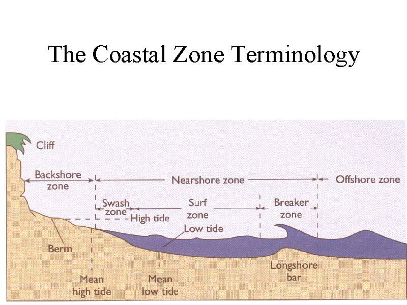
The nearshore zone: this zone extends from the seaward or lakeward edge of breakers to the landward limit reached by the broken wave water.
The breaker zone: the zone where waves break
The surf zone: through which a bore of broken water moves and most landward
The swash zone: the zone over which a thin sheet of water rushes up the inland limit of water and then back toward the surf zone
The offshore zone: this zone accounts for the remainder of the standing body of water
The order of the principal division of the coastal zone.
From closest to farthest of the beach
Nearshore Zone:
Swash zone:
Surf zone:
Breaker zone:
Offshore Zone
Explain how waves are formed and characterized (3 ways)
Wind-driven waves: these waves form as the wind passes over the surface of the water. These are created through fiction and pressure and this energy goes through the water.
Tidal waves: these waves form from the gravitational forces of the earth, sun, and moon. As the Earth rotates, ideas around the world go in and out.
Tsunami waves: these waves form from geological disturbances like earthquakes, landslides, and volcanic eruptions
Identify coastal erosion processes and the primary landforms found on erosion-dominated coastlines.
Corrosion can occur that results in the removal of ions that have been separated from rock-forming minerals by solution
The power of hydraulic action also results in this erosion.
Longshore drift: This is the angled carrying of beach sediment sideways down the coast until it’s deposited.
What are some erosional landforms?
Stack: an isolated column of rock left after the collapse of an arch
What are some depositional landforms?
Sandbar: this landform occurs when a sand spit like formation extends completely across a bay due to continued longshore drift
Lagoon: a saltwater lake that will form as a sandspit extends
Tombolo: a landform that connects an island to a mainland and dunes with grass can give this structure stability
Spit: a feature of the land that extends out from the coastline and that is formed from carried beach sediment (it is sticks straight out like a road)
Spit: