Earth Science - Plate Tectonics, Layers of the Earth, Volcanoes, and Plate Boundaries
==LAYERS OF EARTH==
- @@Crust@@: the outermost layer made up of solid materials and minerals.
- Volcanoes, valleys, mountain ranges forms here
- Mohorovicic discontinuity: boundary between the crust and mantle.
- @@Mantle@@: consists of semiliquid rock
- Makes up the lithosphere, the rigid outer part of the planet.
- @@Core@@: extremely hot and dense due to high pressure and temperature.
- Inner core: solid
- Outer core: liquid
==VOLCANOES==
- Most active volcanoes are located in two volcanic belts: Alpine-Himalayan Belt and Circum-Pacific Belt (Ring of Fire)
- @@Ring of Fire:@@ outlines the major trenches in the Pacific Ocean, is an active volcanic and seismic zone.
- @@Alpine-Himalayan Belt:@@ reveals the collision of the African Plate and Indo-Australian plate with the southern margin of the Eurasian Plate.
- The locations of volcanoes are associated with tectonic activity.
- @@Active volcano:@@ usually associated with seismic activity, presence of hot water spring, and changes of elevation of earth’s crater.
- @@Dormant Volcano:@@ has not erupted but may erupt based on seismic indications.
- @@Extinct Volcano:@@ not active or has not erupted for a longtime.
==EARTHQUAKE EPICENTERS==
- @@Earthquake:@@ series of a series of seismic wave traveling through earth and is a result of sudden release of energy.
- @@Seismic waves@@: body waves that radiate outward in all directions from the center to the earth’s interior.
- Earthquakes usually accompany volcanic eruptions because both are found along the edge of tectonic plates.
- @@Focus@@: the point within Earth where an earthquake rupture starts.
- @@Epicenter@@@@:@@ the geographic point at the surface directly above the focus.

- 8 seconds is the interval between the time of arrival of the P-wave and S-wave at 100 km.
==MOUNTAIN RANGES==
- @@Mountain@@: a landform that rises at least 300m (1000ft)
- Forms in area where Earth’s plates move toward one another –convergent.
- @@Mount Everest@@ highest mountain with an elevation of 8848m (29035 ft.)–sea level and 3600m (12000 ft.) –base to peak. In between Tibet and Nepal
- @@Mountain Range@@: chain of mountains.
- @@Himalayas:@@ highest mountain range. Formed due to the collision of Indian Plate and Eurasian Plate.
- @@Mountain Belts@@: long chain of mountain ranges.
- @@Andes Mountains:@@ Seven South American countries. Collision of Pacific Plate and South American Plate.
==PLATE TECTONICS==
- @@Continental Plates:@@ plates that contain mostly continental landmasses.
- @@Oceanic Plates@@@@:@@ those that form a portion of the ocean bottom.
- @@Plate Tectonic Theory@@: the movement of the lithosphere produced the landforms on Earth’s surface.
- @@Continental Drift Theory@@: Alfred Wegener, a German scientist, hypothesized that the continents were once a single landmass called Pangaea “all land”
- The southern hemisphere manifested similar patterns of rocks and fossils called @@Gondwana Sequence.@@
- In 1940’s and 1950’s the ideas of paleomagnetism, convection currents, and seafloor spreading confirmed Wegener’s Theory.
- @@Convection Current:@@ the movement of materials caused by the difference in their temperatures.
- @@Seafloor Spreading@@: a process that occurs at mid-ocean ridges, where new oceanic crust is formed through volcanic activity and then gradually moves away from the ridge.
- @@Magnetic Stripes:@@
- Magnetic polarity alternates between normal and reversed, magnetic north and south change places.
- Magnetic stripes on one side matches the pattern on the other side.
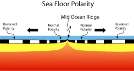
- @@Mid-ocean ridge@@: a large system of underwater mountains that has a rift valley or a deep crack.
- @@Subduction:@@ occurs when the old seafloor plunges back into the interior of earth.
- @@Trenches:@@ deep, v-shaped valleys that lie along the bottom of the oceans.
==PLATE BOUNDARIES==
- The movements of Earth’s tectonic plates caused them to interact in a number of ways, forming different plate boundaries.
- Asthenosphere: plates that lie atop a layer of partially molten rocks.
- Plate Boundaries: Border between two tectonic plates. Deformation of the lithosphere
- ^^Divergent Boundary^^: plates that move apart.
- Also called “Constructive Boundaries” because new material is added to the plates.
- Mid-ocean Ridges, Rift Valleys, Fissure Volcanoes
- ^^Convergent Boundary:^^ occurs due to subduction. Plates move towards each other or pushed under another.
- Also called “Destructive Boundaries” because plate materials is subducted.
- Mountains and volcanoes
- %%Three types of Convergent Boundary:%%
- Oceanic–continental: subduction zone, deep ocean trenches. Stratovolcanoes and Volcanic Mts. on Land.
- Oceanic –oceanic: Subduction zone. Deep Ocean Trenches, Island Arcs, Undersea Volcanism
- Continental-continental: mountain ranges
- ^^Transform Boundary:^^ plates slide past each other.
- Creates fault valley or undersea canyon
- Most earthquake occurs in this boundary.
==EVIDENCE OF PLATE MOVEMENT==
- Evidence from fossils:
- Fossils: remains or traces of plant life and animal life preserved in rocks or sediments.
- Fossils of same species are found in several continents.
- Fossils of Glossopteris: seed fern from Permian period. South Africa, Australia and India.
- Fossils of Mesosaurus: prehistoric reptile. South America, Africa.
- Evidence from Rocks: same age and type.
- Evidence from Glacial Deposits: South America, Africa, India, Australia and Antarctica.
- Evidence from Climatic Change
- Evidence from Paleomagnetism